

Geology of the Lassen volcanic area
Encyclopedia
The geology of the Lassen volcanic area presents a record of sedimentation and volcanic activity in the area in and around Lassen Volcanic National Park
in Northern California
, U.S. The park is located in the southernmost part of the Cascade Mountain Range in the Pacific Northwest
region of the United States. Pacific Oceanic tectonic plates
have plunged below the North American Plate
in this part of North America for hundreds of millions of years. Heat from these subducting
plates have fed scores of volcano
es in California
, Oregon
, Washington and British Columbia
over at least the past 30 million years (see Geology of the Pacific Northwest
) and is also responsible for activities in the Lassen volcanic area.
s streamed down several major mountains that included nearby but now extinct Mount Yana and Mount Maidu to become the Tuscan Formation. Basalt
ic and later andesitic
to dacitic
flows of lava
covered increasingly larger areas of this formation to eventually form the lava plateau
that the park sits on. About 600,000 years ago, Mount Tehama
started to rise as a stratovolcano
in the southwestern corner of the park, eventually reaching an estimated 11000 feet (3,352.8 m) in height. Following a series of eruptions approximately 350,000 years ago, its cone collapsed into itself to form a two-mile (3 km) wide caldera
.
Roughly 27,000 years ago, a dacite lava dome
quickly pushed its way through Tehama's destroyed north-eastern flank, becoming the approximately 1000 feet (304.8 m) shorter Lassen Peak
. Lassen's shape was significantly altered by glacial erosion from 25,000 to 18,000 years ago during the Wisconsin glaciation
. Since then, smaller dacite domes such as the 1,100 year-old Chaos Crags
have formed around Lassen. Phreatic
(steam explosion) eruptions, dacite and andesite lava flows along with cinder cone
formation have persisted into modern times. Most notable of these is the 18th century formation of Cinder Cone
and the 1914 to 1921 eruption of Lassen Peak. The only activity since then has been the constant bubbling of mud pots and steaming of fumarole
s from the various geothermal areas in Lassen Volcanic National Park
. However, a potential exists for renewed vigorous volcanic activity that could threaten life and property in the area.
, which extends northward some 500 miles (804.7 km) from Lassen Peak
within the park through Oregon
and Washington and into British Columbia
. Lassen Peak and the 16 other major Cascade Volcanoes
form a segment of a ring of volcanoes that circle the Pacific Ocean
known collectively as the 'Pacific Ring of Fire
.' The Cascade Volcanoes are fed by heat generated as the Gorda
and Juan de Fuca
tectonic plates are being subducted
below the much larger but lighter North American Plate
. Lying some 300 miles (482.8 km) offshore, the spreading center of the Gorda Plate pushes out about an inch (2.5 cm) of new crust toward the coast of Northernmost California and southern Oregon
every year.
The composition of the molten rock (magma) that feeds volcanism in the Lassen volcanic area ranges widely in its content of silica (Si
O
2); the higher the silica content, the greater the ability of the magma to trap and hold onto gas and water vapor. When high-silica (dacitic
) magma rises to the Earth's surface, the trapped gases and vapors can erupt explosively to produce ash clouds and pyroclastic flow
s that consist of superheated gas, ash and volcanic fragments. Dacite magma that is extruded nonexplosively as lava forms lava dome
s because it is too viscous (sticky) to flow far away from its source. Low-silica (basalt
ic) magma is more fluid and usually erupts as lava in less explosive eruptions than dacite because gas and water vapor escape easily from it. Eruptions of basalt magma typically produce elongate lava flows, as well as build cinder cone
s (piles of small frothy lava fragments or 'cinders') around volcanic vents.
Basaltic volcanism in the Lassen volcanic area occurs mainly along chains of vents aligned in a north or northwest direction, parallel to regional faults. Examples include Poison Buttes, Subglacial Buttes, Tumble Buttes, the Prospect Peak-Red Cinder area, the east side of the Hat Creek Valley and Potato Buttes-Sugarloaf area, and the Red Lake Mountain area. Prolonged basaltic volcanism at a single site can produce a sizeable edifice, like the broad, relatively flat shield volcano
es of Prospect Peak and
Sifford Mountain.
Northwest of the park lies the Klamath Mountains
(a collective term for the Siskiyou, Trinity, Salmon and Marble Mountains). To the west lies the Sacramento Valley
. Just south of the park begins the Sierra Nevada Mountains and to the east lie the Modoc Plateau
and then the Great Basin
.
 All rock now exposed in the area of the park is volcanic
, but this has not always been the case. For hundreds of millions of years, the Lassen region underwent repeated uplifting to form mountain
s, only to have them worn down and submerged under encroaching seas. During the periods of submersion, sand
, mud
and limestone
were deposited. Occasionally volcanic activity was associated with the mountain building.
About 70 million years ago, the area where the Cascade Range is now situated was under the most recent encroachment by the Pacific Ocean. The rocks that make up the modern Sierra Nevada and the Klamath Mountains
were already in existence but deeply buried. Some 70 million years before (140 million years before present), the rocks that now make up the Klamaths broke away from the rocks that now make up the Sierras and moved 60 miles (96.6 km) west, leaving the flooded 'Lassen Strait.' This broad depression was a seaway
that connected the marine basin in California
with that in east central Oregon.
The entire western portion of North America was being deformed from the Laramide orogeny
starting around 70 million years ago. Gradually during millions of years, crustal rocks were folded and fractured and the seas driven away. This same bending and breaking of rocks relieved pressure on the hot material beneath the Earth's crust and permitted magma
to rise toward the surface. Volcanoes burst into activity starting 30 million years ago from Washington southward along the Cascades and in the area now occupied by the Sierra Nevada mountain range. This activity continued until approximately 11 or 12 million years ago. Lava and ash reached a thickness of up to 10000 feet (3,048 m) in some areas, forming what is now known as the western Cascades. These have been eroded until they are now rolling hills.
Meanwhile, toward the end of this activity, eruptions of a different kind took place on an unprecedented scale in eastern Oregon and Washington. From innumerable cracks, floods of highly fluid basaltic lava spread to cover an area of over 200,000 square miles (500,000 km2). Now known as the Columbia Plateau
, this great lava bed of flood basalt
covers much of Oregon, Washington and even parts of Idaho
. Northern California's Modoc Plateau
is a thinner basaltic flow which some geologists associate with the Columbia Plateau, but there are technical objections to this. The High Cascades took shape as a distinct mountain belt as a result of this upheaval and the bending of the thick blanket of volcanic rocks. During the next 10 million years, a series of new basaltic volcanic cones similar to the shield volcano
es now found in Hawaii
were built.
, the Sierra Nevada was uplifted and tilted westward. A series of volcanic mudflows (lahar
s) from three major source areas contributed debris that covered almost 2000 square miles (5,180 km²) to form the oldest distinctive geologic formation
in the High Cascades. The resulting Tuscan Formation is not exposed anywhere in the national park but it is just below the surface in many places within it. The oldest pyroclastic material in the formation is 3 or 4 million years old. The youngest part of the formation consists of interbedded conglomerates
and volcanic breccia
s that are 2 million years old.
One major source of the formation was Mount Yana; centered a few miles (5 km) southwest of Butt Mountain and south of the park. Mount Yana had probably reached its full size of 10000 feet (3,048 m) in elevation and 15 miles (24.1 km) in diameter before Mount Maidu, the second source, had acquired half its growth. Mount Maidu, which eventually surpassed Mount Yana in size, was centered over what is now the town of Mineral, California
but has been extinct for hundreds of thousands of years (the grassy plain around the town is Maidu's caldera
). A third source situated north of Latour Butte made a lesser contribution to the formation. Minor sources included an area near Hatchet Mountain Pass (northwest of Burney Mountain), dikes
south and southwest of Inskip Hill and possibly Campbell Mound (north of Chico, California
).
Meanwhile, within the park boundary other volcanic events were taking place. Basaltic lavas poured forth in the vicinity of Willow Lake in the southwestern portion of the park. These were followed by a very thick sequence of very fluid andesitic
lavas which erupted near Juniper Lake and flowed westward about four miles (6 km). At about the same time, other andesitic lavas poured from several vents on the central plateau
to cover an area of at least 30 square miles (77.7 km²). Included among these flows were the Twin Lake lavas of black porphyritic andesite, which are notable in that they contain xenocrysts of quartz
. The Flatiron andesites spread over the southwestern part of the park area around this time. Apparently, the vents of these lavas renewed activity at a much later date to form three cinder cone
s: Hat Mountain, Crater Butte and Fairfield Peak.
Somewhat later, andesitic lavas poured out from what is now Reading Peak and mainly flowed to the south and east, reaching the head of Warner Valley. By this time, the park's eastern portion had been transformed into a relatively flat plain. The activity was followed by an eruption of the Eastern basalts from volcanoes east of the park. These thick flows have subsequently eroded to produce rugged hills that limit the park on the east. Taken together, these various flows built the lava plateau that the Lassen volcanic area is located on.
called Mount Tehama
(also called Brokeoff Volcano) in what is now the southwest corner of the park. It was made of roughly alternating layers of andesitic lavas and tephra
(volcanic ash
, breccia
, and pumice
) with increasing amounts of tephra
with elevation.
Tehama eventually reached an elevation of about 11000 feet (3,352.8 m), was 11 to 15 mi (17.7 to 24.1 km) wide at its base, and contained 80 km³ of material. Its principal vent lay in the neighborhood of what is now Sulphur Works, but a second vent from which no lavas issued lay on the eastern flank of Little Hot Springs Valley. Contrary to popular belief, Bumpass Hell is not one of Tehama's main vents since it is located outside of the caldera
.
It is possible that Tehama collapsed along a series of fault lines which criss-crossed it. The trigger for this possible collapse may have been the release of the extensive amounts of lava that formed the dacite domes on its flank. More likely, the volcano weathered away; hot volcanic gases and steam turned hard rock into soft clay that were easily eroded by glacial action. Either way, the largest remnants of Tehama include Brokeoff Mountain, Mount Conard, Mount Diller, and Pilot Pinnacle. Andesites erupted again in the area starting approximately 300,000 years ago and dacite erupted in the area between 250,000 to 200,000 years ago and 100,000 years ago through the present.
Four shield volcano
es (Raker and Prospect Peaks, Sifford Mountain and Mount Harkness) grew to elevations of between 7,000 to 8,400 feet (2,130 to 2,560 m) at the corners of the central plateau. Raker Peak erupted andesite lavas while basalt flowed from the others. Each of these volcanoes developed a cinder cone on its summit during their last stages of eruption. Later, a mass of rhyolite
was forced through the north flank of Sifford Mountain and a plug of dacite
was pushed up through the west flank of Raker Peak.
In the past 50,000 years, at least seven major episodes of dacitic volcanism produced lava dome
s and pyroclastic deposits in the Lassen volcanic area, and another five episodes produced basaltic and andesitic
(silica content between basalt and dacite) lava flows. Eruptions have occurred at sites including Lassen Peak, Chaos Crags, and Sunflower Flat (explosive dacite eruptions followed by dome growth) and Tumble Buttes, Hat Mountain, and Prospect Peak (basalt eruptions). In addition, about 30 smaller volcanoes erupted basaltic lavas in the larger region surrounding the Lassen volcanic center.
 Radiometric dating
indicates that around 31,000 years ago a new vent opened up on the northeastern slope of Tehama, probably close to where Lassen Peak
now stands. Streams of fluid dacite flowed chiefly toward the north, reaching a thickness of 1500 feet (457.2 m) and covering perhaps 20 square miles (51.8 km²). Known as the Loomis Sequence, these pre-Lassen dacites are the black, glassy, columnar lavas that now encircle Lassen Peak.
Sometime between 25,000 and 31,000 years ago, Lassen Peak, a Pelean lava dome volcano, was pushed up through the pre-Lassen dacites. Lassen grew past the normal maximum size of plug dome volcanoes, 1000 feet (304.8 m), and reached a height of 1800 feet (548.6 m) above the surrounding plateau in as little as a few years. The surface of the growing pile of about a cubic mile (4 km³) of lava crumbled continually, forming enormous banks of talus
. When Lassen Peak formed it looked much like the nearby Chaos Crags
domes do today, with steep sides covered by angular rock talus. Lassen Peak’s shape was significantly altered by glacial erosion from 25,000 to 18,000 years ago during the Wisconsin glaciation
. At least one of Lassen's glaciers extended as far as 7 miles (11.3 km) from the volcano itself.
Later, but not precisely dated, eruptions from the Lassen volcanic area have formed over 30 smaller steep-sided, mound-shaped accumulations of volcanic rock, called lava domes. Crescent Crater, which at first glance appears as a parasite on Lassen's northeast flank, has been more heavily glaciated and thus is older. Other dacite domes which rose on Tehama's flanks are Bumpass Mountain, Helen Ridge, Eagle Peak, Vulcan's Castle and Reading Peak. An upper limit of 10,000 years has been set for the domes next to Lost Creek (north domes). All of these domes must have risen with great rapidity.
 Glaciation has played an important but incompletely understood role in the park. Glacier
s existed throughout the park area during most of the Pleistocene
with smaller ones persisting at higher elevations until comparatively recent times. Lassen Peak is situated at a center from which many of these glaciers originated. Glacial ice that filled Mill Creek (whose canyon is mostly post-glacial), Blue Lake Canyon, Kings Creek Meadows, Flatiron Ridge, Warner Valley and the valley of Manzanita, Hat and Lost Creeks originated from there. Indeed, Lassen Peak appears to be sitting in the depression carved by the Lost Creek Glacier.
Reading Peak formed a second center from which ice moved north into Hat Creek and Summit Creek. Ice moving southward united with some of the above glaciers and emptied into Warner Valley. On the central plateau, the ridge connecting Hat Mountain with Crater Butte served as a divide between ice flowing northward to Badger Flat and Hat Creek and that moving southward to Corral Meadows, Kings Creek and Warner Valley. Ice from Mt. Harkness and Sifford Mountain also wound up in Warner Valley.
The crest of Saddle Mountain served as a divide with ice north of it moving into the depression containing Snag and Butte Lakes, while those to the south entered Warner Valley. The ice varied from a thickness of 1600 feet (487.7 m) in Warner Valley to much thinner sheets in the higher mountains.
cones developed in a rift extending northwest from the base of Lassen Peak. Then about 1,100 years ago several dacitic domes, the Chaos Crags
, protruded through these cones and obliterated all but half of the southernmost cone. At least 300 years ago a series of large avalanches, possibly triggered by steam explosions
, occurred on the north side of the Crags. These avalanches created their own 'air cushions' that helped accelerate them to speeds exceeding 100 miles per hour (160.9 km/h) and push them partway up Table Mountain. The resulting wilderness of debris, the Chaos Jumbles, covers an area of 2.5 square miles (6.5 km²). Manzanita Lake was formed as a result of Manzanita Creek being dammed by the debris. Steam rose from the domes of Chaos Crags until 1857.
 Around the mid-18th century a series of eruptions produced Cinder Cone
in the northeast corner of the park, mantling an area of 30 square miles (80 km2) with ejecta in the process. Ash falling on the streams of lava pouring from the cone's east flank formed the Painted Dunes. A flow of quartz
-studded basalt lava (the Fantastic Lava Beds) poured from the Cinder Cone and dammed the streams that fed nearby Butte Lake to the north, forming Snag Lake to the south. In the late 18th century Cinder Cone had its most recent eruption and lava flow.
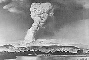 Explosions recurred at irregular intervals on Lassen Peak for most of 1914. Later, on May 19, 1915, a mass of lava rose in the summit crater and spilled 1000 feet (304.8 m) down the western side of the volcano. Extensive lahars (mudflows) were created on the northeastern side as snowbanks were melted. The resulting debris swept down the slope. Divided by Raker Peak, part of this mudflow raced down Lost Creek; the remaining flow passed over the 100-foot (30 m) rise east of the park road and rushed down Hat Creek. A wide barren swath was torn through the forest.
A great explosion blasted out a new crater three days later on May 22, 1915. A volcanic cloud rose 40000 feet (12,192 m), but a portion of the explosive force was deflected downward. The resulting pyroclastic flow
of super-heated gas, rocks and ash roared down the same path taken by the mudflow, resulting in further damage along the headwaters of Hat and Lost Creeks. Ash from the eruption blew eastward with some fine ash falling at least as far as 200 miles (321.9 km) from the volcano. Thereafter, activity declined, finally ending in 1921.
Since then, the volcano has been dormant, although some steam still rises from small vents in its summit and on its flanks. Pumice ejected during the 1915 eruption of Lassen Peak is conspicuously banded with light streaks of dacite and dark andesite, which appears to represent two distinct magmas imperfectly mixed during the eruption. The 1915 eruption of Lassen Peak was the second most recent volcanic outburst in the contiguous 48 U.S. states (after the 1980 eruption of Mount St. Helens
in Washington).
fatalities.
Dacite eruptions in the Lassen area typically begin with steam explosions caused by the interaction of rising magma with ground water. When dacite magma charged with volcanic gases reaches the surface, it erupts explosively, usually as a vertical column of gas and ash that can rise several miles into the atmosphere
. Heavy fallback of hot ash and rock fragments from eruption columns may generate highly mobile pyroclastic flow
s that can rush several miles down a volcano's slopes and adjacent valleys. Fallout from the eruption column can blanket areas within a few miles (~8 km) of the vent with a thick layer of pumice
, and high-altitude winds may carry finer ash tens to hundreds of miles from the volcano, posing a hazard to flying aircraft
, particularly those with jet engine
s.
The areas of highest hazard are those that could be affected by pyroclastic flow
s and lahar
s (see map). These areas, including Hat Creek Valley, are those in the immediate vicinity and downhill from likely eruption sites. Fallout of ash will affect areas downwind at the time of an eruption. Within the hazard zones, relative hazard is gradational, decreasing away from the location of potential vents.
After an initial explosive eruption, extrusion of gas
-depleted dacite
magma commonly forms lava dome
s. Growing lava domes are inherently unstable, and collapse of their steep sides often generates pyroclastic flows of lava blocks and ash that can travel several miles. Such a sequence of events is recorded by the deposits related to the emplacement of Chaos Crags domes between 1,100 and 1,000 years ago.
Interaction of hot pyroclastic flows with snow
and ice
can generate highly mobile flows of mud and debris (called lahar
s) that may rush down valleys leading away from a volcano. Because of this, active volcanoes that have a significant snow and ice cover can be particularly dangerous. The lahars that threatened residents of the Lassen area in May 1915 were generated by relatively small eruptions of Lassen Peak. Nonetheless, they traveled down creek beds as far as 12 miles (19 km) and released floods that affected valleys for 30 mi (48 km) downstream.
s and landslide
s not directly related to eruptions. Recently erupted volcanic domes are unstable and can collapse, generating small to large rockfalls. Approximately 350 years ago, collapse of one of the Chaos Crags domes generated huge rockfalls, creating an area now called the Chaos Jumbles. The first and largest of these traveled 4 miles (6.4 km) downslope and was able to climb 400 feet (121.9 m) up the side of Table Mountain. The trigger for the rockfall is unknown, but it was most likely a large earthquake
. Normal weathering also weakens fractured volcanic rock and contributes to small rockfalls. In the summer of 1994, a rockfall of 13,000 cubic yards (10,000 m3) (the volume of about 500 minivans) occurred on the northeastern flank of Lassen Peak. During periods of extreme rain
fall or snow melt, mudflows are sometimes generated by mobilization of loose volcanic debris and soil on the slopes of volcanoes.
The only current visible activity in the Lassen volcanic area is from the various geothermal areas in Lassen Volcanic National Park
; boiling hot springs
, bubbling mud pots and fuming fumarole
s. Most of these features lie in or are closely adjacent to Mount Tehama
's caldera. In each thermal area, the highest temperature of water generally is close to the boiling temperature at the altitude of the particular spring or fumarole 198 °F (92.2 °C) at Bumpass Hell and 191 °F (88.3 °C) on the northwest flanks of Lassen Peak.
The hottest and most vigorous hydrothermal features in the Lassen volcanic area are at Bumpass Hell, which marks the principal area of upflow and steam discharge from the Lassen hydrothermal system. A prominent steam plume marks the site of Big Boiler, the largest fumarole (steam and volcanic-gas vent) in the park. The temperature of the high-velocity steam jetting from it has been measured as high as 322 °F (161.1 °C). A thin crust of material often covers these boiling hot features, making them a serious burn hazard to anyone walking off trail. The steam-heated waters of the features are typically acid
ic and, even if cool enough, are not safe for bathing.
Lassen Volcanic National Park
Lassen Volcanic National Park is a United States National Park in northeastern California. The dominant feature of the park is Lassen Peak; the largest plug dome volcano in the world and the southern-most volcano in the Cascade Range...
in Northern California
Northern California
Northern California is the northern portion of the U.S. state of California. The San Francisco Bay Area , and Sacramento as well as its metropolitan area are the main population centers...
, U.S. The park is located in the southernmost part of the Cascade Mountain Range in the Pacific Northwest
Pacific Northwest
The Pacific Northwest is a region in northwestern North America, bounded by the Pacific Ocean to the west and, loosely, by the Rocky Mountains on the east. Definitions of the region vary and there is no commonly agreed upon boundary, even among Pacific Northwesterners. A common concept of the...
region of the United States. Pacific Oceanic tectonic plates
Plate tectonics
Plate tectonics is a scientific theory that describes the large scale motions of Earth's lithosphere...
have plunged below the North American Plate
North American Plate
The North American Plate is a tectonic plate covering most of North America, Greenland, Cuba, Bahamas, and parts of Siberia, Japan and Iceland. It extends eastward to the Mid-Atlantic Ridge and westward to the Chersky Range in eastern Siberia. The plate includes both continental and oceanic crust...
in this part of North America for hundreds of millions of years. Heat from these subducting
Subduction
In geology, subduction is the process that takes place at convergent boundaries by which one tectonic plate moves under another tectonic plate, sinking into the Earth's mantle, as the plates converge. These 3D regions of mantle downwellings are known as "Subduction Zones"...
plates have fed scores of volcano
Volcano
2. Bedrock3. Conduit 4. Base5. Sill6. Dike7. Layers of ash emitted by the volcano8. Flank| 9. Layers of lava emitted by the volcano10. Throat11. Parasitic cone12. Lava flow13. Vent14. Crater15...
es in California
California
California is a state located on the West Coast of the United States. It is by far the most populous U.S. state, and the third-largest by land area...
, Oregon
Oregon
Oregon is a state in the Pacific Northwest region of the United States. It is located on the Pacific coast, with Washington to the north, California to the south, Nevada on the southeast and Idaho to the east. The Columbia and Snake rivers delineate much of Oregon's northern and eastern...
, Washington and British Columbia
British Columbia
British Columbia is the westernmost of Canada's provinces and is known for its natural beauty, as reflected in its Latin motto, Splendor sine occasu . Its name was chosen by Queen Victoria in 1858...
over at least the past 30 million years (see Geology of the Pacific Northwest
Geology of the Pacific Northwest
The geology of the Pacific Northwest refers to the study of the composition , structure, physical properties and the processes that shape the Pacific Northwest region of the United States and Canada...
) and is also responsible for activities in the Lassen volcanic area.
Geologic history
Between 3 and 4 million years ago, volcanic-derived mud flows called laharLahar
A lahar is a type of mudflow or debris flow composed of a slurry of pyroclastic material, rocky debris, and water. The material flows down from a volcano, typically along a river valley. The term is a shortened version of "berlahar" which originated in the Javanese language of...
s streamed down several major mountains that included nearby but now extinct Mount Yana and Mount Maidu to become the Tuscan Formation. Basalt
Basalt
Basalt is a common extrusive volcanic rock. It is usually grey to black and fine-grained due to rapid cooling of lava at the surface of a planet. It may be porphyritic containing larger crystals in a fine matrix, or vesicular, or frothy scoria. Unweathered basalt is black or grey...
ic and later andesitic
Andesite
Andesite is an extrusive igneous, volcanic rock, of intermediate composition, with aphanitic to porphyritic texture. In a general sense, it is the intermediate type between basalt and dacite. The mineral assemblage is typically dominated by plagioclase plus pyroxene and/or hornblende. Magnetite,...
to dacitic
Dacite
Dacite is an igneous, volcanic rock. It has an aphanitic to porphyritic texture and is intermediate in composition between andesite and rhyolite. The relative proportions of feldspars and quartz in dacite, and in many other volcanic rocks, are illustrated in the QAPF diagram...
flows of lava
Lava
Lava refers both to molten rock expelled by a volcano during an eruption and the resulting rock after solidification and cooling. This molten rock is formed in the interior of some planets, including Earth, and some of their satellites. When first erupted from a volcanic vent, lava is a liquid at...
covered increasingly larger areas of this formation to eventually form the lava plateau
Volcanic plateau
A volcanic plateau is a plateau produced by volcanic activity. There are two main types: lava plateaus and pyroclastic plateaus.-Lava plateau:...
that the park sits on. About 600,000 years ago, Mount Tehama
Mount Tehama
Mount Tehama is an eroded andesitic stratovolcano in the Cascade Volcanic Arc and the Cascade Range in Northern California. Part of the Lassen volcanic center, its highest remaining remnant, Brokeoff Mountain, is itself the second highest peak in Lassen Volcanic National Park and connects to the...
started to rise as a stratovolcano
Stratovolcano
A stratovolcano, also known as a composite volcano, is a tall, conical volcano built up by many layers of hardened lava, tephra, pumice, and volcanic ash. Unlike shield volcanoes, stratovolcanoes are characterized by a steep profile and periodic, explosive eruptions...
in the southwestern corner of the park, eventually reaching an estimated 11000 feet (3,352.8 m) in height. Following a series of eruptions approximately 350,000 years ago, its cone collapsed into itself to form a two-mile (3 km) wide caldera
Caldera
A caldera is a cauldron-like volcanic feature usually formed by the collapse of land following a volcanic eruption, such as the one at Yellowstone National Park in the US. They are sometimes confused with volcanic craters...
.
Roughly 27,000 years ago, a dacite lava dome
Lava dome
|250px|thumb|right|Image of the [[rhyolitic]] lava dome of [[Chaitén Volcano]] during its 2008–2009 eruption.In volcanology, a lava dome is a roughly circular mound-shaped protrusion resulting from the slow extrusion of viscous lava from a volcano...
quickly pushed its way through Tehama's destroyed north-eastern flank, becoming the approximately 1000 feet (304.8 m) shorter Lassen Peak
Lassen Peak
Lassen Peak is the southernmost active volcano in the Cascade Range. It is part of the Cascade Volcanic Arc which is an arc that stretches from northern California to southwestern British Columbia...
. Lassen's shape was significantly altered by glacial erosion from 25,000 to 18,000 years ago during the Wisconsin glaciation
Wisconsin glaciation
The last glacial period was the most recent glacial period within the current ice age occurring during the last years of the Pleistocene, from approximately 110,000 to 10,000 years ago....
. Since then, smaller dacite domes such as the 1,100 year-old Chaos Crags
Chaos Crags
Chaos Crags is the youngest group of lava domes in Lassen Volcanic National Park, California, having been formed as five dacite domes 1,100-1,000 years ago...
have formed around Lassen. Phreatic
Phreatic
The term phreatic is used in Earth sciences to refer to matters relating to ground water below the water table . The term 'phreatic surface' indicates the location where the pore water pressure is under atmospheric conditions...
(steam explosion) eruptions, dacite and andesite lava flows along with cinder cone
Cinder cone
According to the , Cinder Cone is the proper name of 1 cinder cone in Canada and 7 cinder cones in the United States:In Canada: Cinder Cone In the United States:...
formation have persisted into modern times. Most notable of these is the 18th century formation of Cinder Cone
Cinder Cone and the Fantastic Lava Beds
Cinder Cone is a cinder cone volcano in Lassen Volcanic National Park . Within the park it is located about northeast of Lassen Peak and provides an excellent view of Brokeoff Mountain, Lassen Peak, and Chaos Crags.The cone was built to a height of above the surrounding area and spread ash over...
and the 1914 to 1921 eruption of Lassen Peak. The only activity since then has been the constant bubbling of mud pots and steaming of fumarole
Fumarole
A fumarole is an opening in a planet's crust, often in the neighborhood of volcanoes, which emits steam and gases such as carbon dioxide, sulfur dioxide, hydrochloric acid, and hydrogen sulfide. The steam is created when superheated water turns to steam as its pressure drops when it emerges from...
s from the various geothermal areas in Lassen Volcanic National Park
Geothermal areas in Lassen Volcanic National Park
Several groups of hot springs and fumaroles, remnants of former volcanic activity, exist in Lassen Volcanic National Park. Most of these lie in or are closely adjacent to Mount Tehama's caldera. Bumpass Hell is the most spectacular of these, but others of importance are Sulphur Works, Little Hot...
. However, a potential exists for renewed vigorous volcanic activity that could threaten life and property in the area.
Current setting
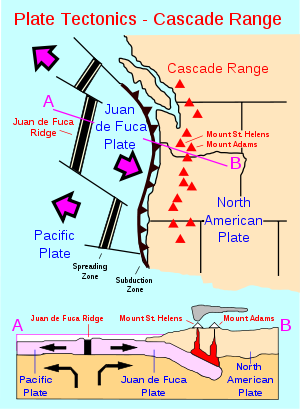
The Lassen volcanic area lies at the southern extremity of the Cascade RangeCascade Range
The Cascade Range is a major mountain range of western North America, extending from southern British Columbia through Washington and Oregon to Northern California. It includes both non-volcanic mountains, such as the North Cascades, and the notable volcanoes known as the High Cascades...
, which extends northward some 500 miles (804.7 km) from Lassen Peak
Lassen Peak
Lassen Peak is the southernmost active volcano in the Cascade Range. It is part of the Cascade Volcanic Arc which is an arc that stretches from northern California to southwestern British Columbia...
within the park through Oregon
Oregon
Oregon is a state in the Pacific Northwest region of the United States. It is located on the Pacific coast, with Washington to the north, California to the south, Nevada on the southeast and Idaho to the east. The Columbia and Snake rivers delineate much of Oregon's northern and eastern...
and Washington and into British Columbia
British Columbia
British Columbia is the westernmost of Canada's provinces and is known for its natural beauty, as reflected in its Latin motto, Splendor sine occasu . Its name was chosen by Queen Victoria in 1858...
. Lassen Peak and the 16 other major Cascade Volcanoes
Cascade Volcanoes
The Cascade Volcanoes are a number of volcanoes in a volcanic arc in western North America, extending from southwestern British Columbia through Washington and Oregon to Northern California, a distance of well over 700 mi ...
form a segment of a ring of volcanoes that circle the Pacific Ocean
Pacific Ocean
The Pacific Ocean is the largest of the Earth's oceanic divisions. It extends from the Arctic in the north to the Southern Ocean in the south, bounded by Asia and Australia in the west, and the Americas in the east.At 165.2 million square kilometres in area, this largest division of the World...
known collectively as the 'Pacific Ring of Fire
Pacific Ring of Fire
The Pacific Ring of Fire is an area where large numbers of earthquakes and volcanic eruptions occur in the basin of the Pacific Ocean. In a horseshoe shape, it is associated with a nearly continuous series of oceanic trenches, volcanic arcs, and volcanic belts and/or plate movements...
.' The Cascade Volcanoes are fed by heat generated as the Gorda
Gorda Plate
The Gorda Plate, located beneath the Pacific Ocean off the coast of northern California, is one of the northern remnants of the Farallon Plate. It is sometimes referred to as simply the southernmost portion of the neighboring Juan de Fuca Plate, another Farallon remnant.Unlike most tectonic...
and Juan de Fuca
Juan de Fuca Plate
The Juan de Fuca Plate, named after the explorer of the same name, is a tectonic plate, generated from the Juan de Fuca Ridge, and subducting under the northerly portion of the western side of the North American Plate at the Cascadia subduction zone...
tectonic plates are being subducted
Subduction
In geology, subduction is the process that takes place at convergent boundaries by which one tectonic plate moves under another tectonic plate, sinking into the Earth's mantle, as the plates converge. These 3D regions of mantle downwellings are known as "Subduction Zones"...
below the much larger but lighter North American Plate
North American Plate
The North American Plate is a tectonic plate covering most of North America, Greenland, Cuba, Bahamas, and parts of Siberia, Japan and Iceland. It extends eastward to the Mid-Atlantic Ridge and westward to the Chersky Range in eastern Siberia. The plate includes both continental and oceanic crust...
. Lying some 300 miles (482.8 km) offshore, the spreading center of the Gorda Plate pushes out about an inch (2.5 cm) of new crust toward the coast of Northernmost California and southern Oregon
Oregon
Oregon is a state in the Pacific Northwest region of the United States. It is located on the Pacific coast, with Washington to the north, California to the south, Nevada on the southeast and Idaho to the east. The Columbia and Snake rivers delineate much of Oregon's northern and eastern...
every year.
The composition of the molten rock (magma) that feeds volcanism in the Lassen volcanic area ranges widely in its content of silica (Si
Silicon
Silicon is a chemical element with the symbol Si and atomic number 14. A tetravalent metalloid, it is less reactive than its chemical analog carbon, the nonmetal directly above it in the periodic table, but more reactive than germanium, the metalloid directly below it in the table...
O
Oxygen
Oxygen is the element with atomic number 8 and represented by the symbol O. Its name derives from the Greek roots ὀξύς and -γενής , because at the time of naming, it was mistakenly thought that all acids required oxygen in their composition...
2); the higher the silica content, the greater the ability of the magma to trap and hold onto gas and water vapor. When high-silica (dacitic
Dacite
Dacite is an igneous, volcanic rock. It has an aphanitic to porphyritic texture and is intermediate in composition between andesite and rhyolite. The relative proportions of feldspars and quartz in dacite, and in many other volcanic rocks, are illustrated in the QAPF diagram...
) magma rises to the Earth's surface, the trapped gases and vapors can erupt explosively to produce ash clouds and pyroclastic flow
Pyroclastic flow
A pyroclastic flow is a fast-moving current of superheated gas and rock , which reaches speeds moving away from a volcano of up to 700 km/h . The flows normally hug the ground and travel downhill, or spread laterally under gravity...
s that consist of superheated gas, ash and volcanic fragments. Dacite magma that is extruded nonexplosively as lava forms lava dome
Lava dome
|250px|thumb|right|Image of the [[rhyolitic]] lava dome of [[Chaitén Volcano]] during its 2008–2009 eruption.In volcanology, a lava dome is a roughly circular mound-shaped protrusion resulting from the slow extrusion of viscous lava from a volcano...
s because it is too viscous (sticky) to flow far away from its source. Low-silica (basalt
Basalt
Basalt is a common extrusive volcanic rock. It is usually grey to black and fine-grained due to rapid cooling of lava at the surface of a planet. It may be porphyritic containing larger crystals in a fine matrix, or vesicular, or frothy scoria. Unweathered basalt is black or grey...
ic) magma is more fluid and usually erupts as lava in less explosive eruptions than dacite because gas and water vapor escape easily from it. Eruptions of basalt magma typically produce elongate lava flows, as well as build cinder cone
Cinder cone
According to the , Cinder Cone is the proper name of 1 cinder cone in Canada and 7 cinder cones in the United States:In Canada: Cinder Cone In the United States:...
s (piles of small frothy lava fragments or 'cinders') around volcanic vents.
Basaltic volcanism in the Lassen volcanic area occurs mainly along chains of vents aligned in a north or northwest direction, parallel to regional faults. Examples include Poison Buttes, Subglacial Buttes, Tumble Buttes, the Prospect Peak-Red Cinder area, the east side of the Hat Creek Valley and Potato Buttes-Sugarloaf area, and the Red Lake Mountain area. Prolonged basaltic volcanism at a single site can produce a sizeable edifice, like the broad, relatively flat shield volcano
Shield volcano
A shield volcano is a type of volcano usually built almost entirely of fluid lava flows. They are named for their large size and low profile, resembling a warrior's shield. This is caused by the highly fluid lava they erupt, which travels farther than lava erupted from more explosive volcanoes...
es of Prospect Peak and
Sifford Mountain.
Northwest of the park lies the Klamath Mountains
Klamath Mountains
The Klamath Mountains, which include the Siskiyou, Marble, Scott, Trinity, Trinity Alps, Salmon, and northern Yolla-Bolly Mountains, are a rugged lightly populated mountain range in northwest California and southwest Oregon in the United States...
(a collective term for the Siskiyou, Trinity, Salmon and Marble Mountains). To the west lies the Sacramento Valley
Sacramento Valley
The Sacramento Valley is the portion of the California Central Valley that lies to the north of the San Joaquin-Sacramento Delta in the U.S. state of California. It encompasses all or parts of ten counties.-Geography:...
. Just south of the park begins the Sierra Nevada Mountains and to the east lie the Modoc Plateau
Modoc Plateau
The Modoc Plateau lies in the northeast corner of California as well as parts of Oregon and Nevada. It is a mile-high expanse of lava flows with cinder cones, juniper flats, pine forests, and seasonal lakes. The plateau is thought to have been formed approximately 25 million years ago...
and then the Great Basin
Great Basin
The Great Basin is the largest area of contiguous endorheic watersheds in North America and is noted for its arid conditions and Basin and Range topography that varies from the North American low point at Badwater Basin to the highest point of the contiguous United States, less than away at the...
.
Geologic history of the region
Volcanic rock
Volcanic rock is a rock formed from magma erupted from a volcano. In other words, it is an igneous rock of volcanic origin...
, but this has not always been the case. For hundreds of millions of years, the Lassen region underwent repeated uplifting to form mountain
Mountain
Image:Himalaya_annotated.jpg|thumb|right|The Himalayan mountain range with Mount Everestrect 58 14 160 49 Chomo Lonzorect 200 28 335 52 Makalurect 378 24 566 45 Mount Everestrect 188 581 920 656 Tibetan Plateaurect 250 406 340 427 Rong River...
s, only to have them worn down and submerged under encroaching seas. During the periods of submersion, sand
Sand
Sand is a naturally occurring granular material composed of finely divided rock and mineral particles.The composition of sand is highly variable, depending on the local rock sources and conditions, but the most common constituent of sand in inland continental settings and non-tropical coastal...
, mud
Mud
Mud is a mixture of water and some combination of soil, silt, and clay. Ancient mud deposits harden over geological time to form sedimentary rock such as shale or mudstone . When geological deposits of mud are formed in estuaries the resultant layers are termed bay muds...
and limestone
Limestone
Limestone is a sedimentary rock composed largely of the minerals calcite and aragonite, which are different crystal forms of calcium carbonate . Many limestones are composed from skeletal fragments of marine organisms such as coral or foraminifera....
were deposited. Occasionally volcanic activity was associated with the mountain building.
About 70 million years ago, the area where the Cascade Range is now situated was under the most recent encroachment by the Pacific Ocean. The rocks that make up the modern Sierra Nevada and the Klamath Mountains
Klamath Mountains
The Klamath Mountains, which include the Siskiyou, Marble, Scott, Trinity, Trinity Alps, Salmon, and northern Yolla-Bolly Mountains, are a rugged lightly populated mountain range in northwest California and southwest Oregon in the United States...
were already in existence but deeply buried. Some 70 million years before (140 million years before present), the rocks that now make up the Klamaths broke away from the rocks that now make up the Sierras and moved 60 miles (96.6 km) west, leaving the flooded 'Lassen Strait.' This broad depression was a seaway
Seaway
Seaway is a Canadian drama series that aired on CBC from 1965 to 1966. The series was a Seaway Films production in collaboration with the UK's ATV, with production money provided by the CBC...
that connected the marine basin in California
California
California is a state located on the West Coast of the United States. It is by far the most populous U.S. state, and the third-largest by land area...
with that in east central Oregon.
The entire western portion of North America was being deformed from the Laramide orogeny
Laramide orogeny
The Laramide orogeny was a period of mountain building in western North America, which started in the Late Cretaceous, 70 to 80 million years ago, and ended 35 to 55 million years ago. The exact duration and ages of beginning and end of the orogeny are in dispute, as is the cause. The Laramide...
starting around 70 million years ago. Gradually during millions of years, crustal rocks were folded and fractured and the seas driven away. This same bending and breaking of rocks relieved pressure on the hot material beneath the Earth's crust and permitted magma
Magma
Magma is a mixture of molten rock, volatiles and solids that is found beneath the surface of the Earth, and is expected to exist on other terrestrial planets. Besides molten rock, magma may also contain suspended crystals and dissolved gas and sometimes also gas bubbles. Magma often collects in...
to rise toward the surface. Volcanoes burst into activity starting 30 million years ago from Washington southward along the Cascades and in the area now occupied by the Sierra Nevada mountain range. This activity continued until approximately 11 or 12 million years ago. Lava and ash reached a thickness of up to 10000 feet (3,048 m) in some areas, forming what is now known as the western Cascades. These have been eroded until they are now rolling hills.
Meanwhile, toward the end of this activity, eruptions of a different kind took place on an unprecedented scale in eastern Oregon and Washington. From innumerable cracks, floods of highly fluid basaltic lava spread to cover an area of over 200,000 square miles (500,000 km2). Now known as the Columbia Plateau
Columbia Plateau
The Columbia Plateau is a geologic and geographic region that lies across parts of the U.S. states of Washington, Oregon, and Idaho. It is a wide flood basalt plateau between the Cascade Range and the Rocky Mountains, cut through by the Columbia River...
, this great lava bed of flood basalt
Flood basalt
A flood basalt or trap basalt is the result of a giant volcanic eruption or series of eruptions that coats large stretches of land or the ocean floor with basalt lava. Flood basalts have occurred on continental scales in prehistory, creating great plateaus and mountain ranges...
covers much of Oregon, Washington and even parts of Idaho
Idaho
Idaho is a state in the Rocky Mountain area of the United States. The state's largest city and capital is Boise. Residents are called "Idahoans". Idaho was admitted to the Union on July 3, 1890, as the 43rd state....
. Northern California's Modoc Plateau
Modoc Plateau
The Modoc Plateau lies in the northeast corner of California as well as parts of Oregon and Nevada. It is a mile-high expanse of lava flows with cinder cones, juniper flats, pine forests, and seasonal lakes. The plateau is thought to have been formed approximately 25 million years ago...
is a thinner basaltic flow which some geologists associate with the Columbia Plateau, but there are technical objections to this. The High Cascades took shape as a distinct mountain belt as a result of this upheaval and the bending of the thick blanket of volcanic rocks. During the next 10 million years, a series of new basaltic volcanic cones similar to the shield volcano
Shield volcano
A shield volcano is a type of volcano usually built almost entirely of fluid lava flows. They are named for their large size and low profile, resembling a warrior's shield. This is caused by the highly fluid lava they erupt, which travels farther than lava erupted from more explosive volcanoes...
es now found in Hawaii
Hawaii
Hawaii is the newest of the 50 U.S. states , and is the only U.S. state made up entirely of islands. It is the northernmost island group in Polynesia, occupying most of an archipelago in the central Pacific Ocean, southwest of the continental United States, southeast of Japan, and northeast of...
were built.
Formation of basement rocks
Between two and three million years ago, during the PliocenePliocene
The Pliocene Epoch is the period in the geologic timescale that extends from 5.332 million to 2.588 million years before present. It is the second and youngest epoch of the Neogene Period in the Cenozoic Era. The Pliocene follows the Miocene Epoch and is followed by the Pleistocene Epoch...
, the Sierra Nevada was uplifted and tilted westward. A series of volcanic mudflows (lahar
Lahar
A lahar is a type of mudflow or debris flow composed of a slurry of pyroclastic material, rocky debris, and water. The material flows down from a volcano, typically along a river valley. The term is a shortened version of "berlahar" which originated in the Javanese language of...
s) from three major source areas contributed debris that covered almost 2000 square miles (5,180 km²) to form the oldest distinctive geologic formation
Geologic formation
A formation or geological formation is the fundamental unit of lithostratigraphy. A formation consists of a certain number of rock strata that have a comparable lithology, facies or other similar properties...
in the High Cascades. The resulting Tuscan Formation is not exposed anywhere in the national park but it is just below the surface in many places within it. The oldest pyroclastic material in the formation is 3 or 4 million years old. The youngest part of the formation consists of interbedded conglomerates
Conglomerate (geology)
A conglomerate is a rock consisting of individual clasts within a finer-grained matrix that have become cemented together. Conglomerates are sedimentary rocks consisting of rounded fragments and are thus differentiated from breccias, which consist of angular clasts...
and volcanic breccia
Breccia
Breccia is a rock composed of broken fragments of minerals or rock cemented together by a fine-grained matrix, that can be either similar to or different from the composition of the fragments....
s that are 2 million years old.
One major source of the formation was Mount Yana; centered a few miles (5 km) southwest of Butt Mountain and south of the park. Mount Yana had probably reached its full size of 10000 feet (3,048 m) in elevation and 15 miles (24.1 km) in diameter before Mount Maidu, the second source, had acquired half its growth. Mount Maidu, which eventually surpassed Mount Yana in size, was centered over what is now the town of Mineral, California
Mineral, California
Mineral is a census-designated place in Tehama County, California, United States. The population was 123 at the 2010 census, down from 143 at the 2000 census.-Geography:Mineral is located at ....
but has been extinct for hundreds of thousands of years (the grassy plain around the town is Maidu's caldera
Caldera
A caldera is a cauldron-like volcanic feature usually formed by the collapse of land following a volcanic eruption, such as the one at Yellowstone National Park in the US. They are sometimes confused with volcanic craters...
). A third source situated north of Latour Butte made a lesser contribution to the formation. Minor sources included an area near Hatchet Mountain Pass (northwest of Burney Mountain), dikes
Dike (geology)
A dike or dyke in geology is a type of sheet intrusion referring to any geologic body that cuts discordantly across* planar wall rock structures, such as bedding or foliation...
south and southwest of Inskip Hill and possibly Campbell Mound (north of Chico, California
Chico, California
Chico is the most populous city in Butte County, California, United States. The population was 86,187 at the 2010 census, up from 59,954 at the time of the 2000 census...
).
Meanwhile, within the park boundary other volcanic events were taking place. Basaltic lavas poured forth in the vicinity of Willow Lake in the southwestern portion of the park. These were followed by a very thick sequence of very fluid andesitic
Andesite
Andesite is an extrusive igneous, volcanic rock, of intermediate composition, with aphanitic to porphyritic texture. In a general sense, it is the intermediate type between basalt and dacite. The mineral assemblage is typically dominated by plagioclase plus pyroxene and/or hornblende. Magnetite,...
lavas which erupted near Juniper Lake and flowed westward about four miles (6 km). At about the same time, other andesitic lavas poured from several vents on the central plateau
Plateau
In geology and earth science, a plateau , also called a high plain or tableland, is an area of highland, usually consisting of relatively flat terrain. A highly eroded plateau is called a dissected plateau...
to cover an area of at least 30 square miles (77.7 km²). Included among these flows were the Twin Lake lavas of black porphyritic andesite, which are notable in that they contain xenocrysts of quartz
Quartz
Quartz is the second-most-abundant mineral in the Earth's continental crust, after feldspar. It is made up of a continuous framework of SiO4 silicon–oxygen tetrahedra, with each oxygen being shared between two tetrahedra, giving an overall formula SiO2. There are many different varieties of quartz,...
. The Flatiron andesites spread over the southwestern part of the park area around this time. Apparently, the vents of these lavas renewed activity at a much later date to form three cinder cone
Cinder cone
According to the , Cinder Cone is the proper name of 1 cinder cone in Canada and 7 cinder cones in the United States:In Canada: Cinder Cone In the United States:...
s: Hat Mountain, Crater Butte and Fairfield Peak.
Somewhat later, andesitic lavas poured out from what is now Reading Peak and mainly flowed to the south and east, reaching the head of Warner Valley. By this time, the park's eastern portion had been transformed into a relatively flat plain. The activity was followed by an eruption of the Eastern basalts from volcanoes east of the park. These thick flows have subsequently eroded to produce rugged hills that limit the park on the east. Taken together, these various flows built the lava plateau that the Lassen volcanic area is located on.
Mount Tehama and pre-Lassen volcanics
From 600,000 to 400,000 years ago, eruptions built a large conical stratovolcanoStratovolcano
A stratovolcano, also known as a composite volcano, is a tall, conical volcano built up by many layers of hardened lava, tephra, pumice, and volcanic ash. Unlike shield volcanoes, stratovolcanoes are characterized by a steep profile and periodic, explosive eruptions...
called Mount Tehama
Mount Tehama
Mount Tehama is an eroded andesitic stratovolcano in the Cascade Volcanic Arc and the Cascade Range in Northern California. Part of the Lassen volcanic center, its highest remaining remnant, Brokeoff Mountain, is itself the second highest peak in Lassen Volcanic National Park and connects to the...
(also called Brokeoff Volcano) in what is now the southwest corner of the park. It was made of roughly alternating layers of andesitic lavas and tephra
Tephra
200px|thumb|right|Tephra horizons in south-central [[Iceland]]. The thick and light coloured layer at center of the photo is [[rhyolitic]] tephra from [[Hekla]]....
(volcanic ash
Volcanic ash
Volcanic ash consists of small tephra, which are bits of pulverized rock and glass created by volcanic eruptions, less than in diameter. There are three mechanisms of volcanic ash formation: gas release under decompression causing magmatic eruptions; thermal contraction from chilling on contact...
, breccia
Breccia
Breccia is a rock composed of broken fragments of minerals or rock cemented together by a fine-grained matrix, that can be either similar to or different from the composition of the fragments....
, and pumice
Pumice
Pumice is a textural term for a volcanic rock that is a solidified frothy lava typically created when super-heated, highly pressurized rock is violently ejected from a volcano. It can be formed when lava and water are mixed. This unusual formation is due to the simultaneous actions of rapid...
) with increasing amounts of tephra
Tephra
200px|thumb|right|Tephra horizons in south-central [[Iceland]]. The thick and light coloured layer at center of the photo is [[rhyolitic]] tephra from [[Hekla]]....
with elevation.
Tehama eventually reached an elevation of about 11000 feet (3,352.8 m), was 11 to 15 mi (17.7 to 24.1 km) wide at its base, and contained 80 km³ of material. Its principal vent lay in the neighborhood of what is now Sulphur Works, but a second vent from which no lavas issued lay on the eastern flank of Little Hot Springs Valley. Contrary to popular belief, Bumpass Hell is not one of Tehama's main vents since it is located outside of the caldera
Caldera
A caldera is a cauldron-like volcanic feature usually formed by the collapse of land following a volcanic eruption, such as the one at Yellowstone National Park in the US. They are sometimes confused with volcanic craters...
.
It is possible that Tehama collapsed along a series of fault lines which criss-crossed it. The trigger for this possible collapse may have been the release of the extensive amounts of lava that formed the dacite domes on its flank. More likely, the volcano weathered away; hot volcanic gases and steam turned hard rock into soft clay that were easily eroded by glacial action. Either way, the largest remnants of Tehama include Brokeoff Mountain, Mount Conard, Mount Diller, and Pilot Pinnacle. Andesites erupted again in the area starting approximately 300,000 years ago and dacite erupted in the area between 250,000 to 200,000 years ago and 100,000 years ago through the present.
Four shield volcano
Shield volcano
A shield volcano is a type of volcano usually built almost entirely of fluid lava flows. They are named for their large size and low profile, resembling a warrior's shield. This is caused by the highly fluid lava they erupt, which travels farther than lava erupted from more explosive volcanoes...
es (Raker and Prospect Peaks, Sifford Mountain and Mount Harkness) grew to elevations of between 7,000 to 8,400 feet (2,130 to 2,560 m) at the corners of the central plateau. Raker Peak erupted andesite lavas while basalt flowed from the others. Each of these volcanoes developed a cinder cone on its summit during their last stages of eruption. Later, a mass of rhyolite
Rhyolite
This page is about a volcanic rock. For the ghost town see Rhyolite, Nevada, and for the satellite system, see Rhyolite/Aquacade.Rhyolite is an igneous, volcanic rock, of felsic composition . It may have any texture from glassy to aphanitic to porphyritic...
was forced through the north flank of Sifford Mountain and a plug of dacite
Dacite
Dacite is an igneous, volcanic rock. It has an aphanitic to porphyritic texture and is intermediate in composition between andesite and rhyolite. The relative proportions of feldspars and quartz in dacite, and in many other volcanic rocks, are illustrated in the QAPF diagram...
was pushed up through the west flank of Raker Peak.
In the past 50,000 years, at least seven major episodes of dacitic volcanism produced lava dome
Lava dome
|250px|thumb|right|Image of the [[rhyolitic]] lava dome of [[Chaitén Volcano]] during its 2008–2009 eruption.In volcanology, a lava dome is a roughly circular mound-shaped protrusion resulting from the slow extrusion of viscous lava from a volcano...
s and pyroclastic deposits in the Lassen volcanic area, and another five episodes produced basaltic and andesitic
Andesite
Andesite is an extrusive igneous, volcanic rock, of intermediate composition, with aphanitic to porphyritic texture. In a general sense, it is the intermediate type between basalt and dacite. The mineral assemblage is typically dominated by plagioclase plus pyroxene and/or hornblende. Magnetite,...
(silica content between basalt and dacite) lava flows. Eruptions have occurred at sites including Lassen Peak, Chaos Crags, and Sunflower Flat (explosive dacite eruptions followed by dome growth) and Tumble Buttes, Hat Mountain, and Prospect Peak (basalt eruptions). In addition, about 30 smaller volcanoes erupted basaltic lavas in the larger region surrounding the Lassen volcanic center.
Development of Lassen Peak
Radiometric dating
Radiometric dating is a technique used to date materials such as rocks, usually based on a comparison between the observed abundance of a naturally occurring radioactive isotope and its decay products, using known decay rates...
indicates that around 31,000 years ago a new vent opened up on the northeastern slope of Tehama, probably close to where Lassen Peak
Lassen Peak
Lassen Peak is the southernmost active volcano in the Cascade Range. It is part of the Cascade Volcanic Arc which is an arc that stretches from northern California to southwestern British Columbia...
now stands. Streams of fluid dacite flowed chiefly toward the north, reaching a thickness of 1500 feet (457.2 m) and covering perhaps 20 square miles (51.8 km²). Known as the Loomis Sequence, these pre-Lassen dacites are the black, glassy, columnar lavas that now encircle Lassen Peak.
Sometime between 25,000 and 31,000 years ago, Lassen Peak, a Pelean lava dome volcano, was pushed up through the pre-Lassen dacites. Lassen grew past the normal maximum size of plug dome volcanoes, 1000 feet (304.8 m), and reached a height of 1800 feet (548.6 m) above the surrounding plateau in as little as a few years. The surface of the growing pile of about a cubic mile (4 km³) of lava crumbled continually, forming enormous banks of talus
Scree
Scree, also called talus, is a term given to an accumulation of broken rock fragments at the base of crags, mountain cliffs, or valley shoulders. Landforms associated with these materials are sometimes called scree slopes or talus piles...
. When Lassen Peak formed it looked much like the nearby Chaos Crags
Chaos Crags
Chaos Crags is the youngest group of lava domes in Lassen Volcanic National Park, California, having been formed as five dacite domes 1,100-1,000 years ago...
domes do today, with steep sides covered by angular rock talus. Lassen Peak’s shape was significantly altered by glacial erosion from 25,000 to 18,000 years ago during the Wisconsin glaciation
Wisconsin glaciation
The last glacial period was the most recent glacial period within the current ice age occurring during the last years of the Pleistocene, from approximately 110,000 to 10,000 years ago....
. At least one of Lassen's glaciers extended as far as 7 miles (11.3 km) from the volcano itself.
Later, but not precisely dated, eruptions from the Lassen volcanic area have formed over 30 smaller steep-sided, mound-shaped accumulations of volcanic rock, called lava domes. Crescent Crater, which at first glance appears as a parasite on Lassen's northeast flank, has been more heavily glaciated and thus is older. Other dacite domes which rose on Tehama's flanks are Bumpass Mountain, Helen Ridge, Eagle Peak, Vulcan's Castle and Reading Peak. An upper limit of 10,000 years has been set for the domes next to Lost Creek (north domes). All of these domes must have risen with great rapidity.
Glacial action
Glacier
A glacier is a large persistent body of ice that forms where the accumulation of snow exceeds its ablation over many years, often centuries. At least 0.1 km² in area and 50 m thick, but often much larger, a glacier slowly deforms and flows due to stresses induced by its weight...
s existed throughout the park area during most of the Pleistocene
Pleistocene
The Pleistocene is the epoch from 2,588,000 to 11,700 years BP that spans the world's recent period of repeated glaciations. The name pleistocene is derived from the Greek and ....
with smaller ones persisting at higher elevations until comparatively recent times. Lassen Peak is situated at a center from which many of these glaciers originated. Glacial ice that filled Mill Creek (whose canyon is mostly post-glacial), Blue Lake Canyon, Kings Creek Meadows, Flatiron Ridge, Warner Valley and the valley of Manzanita, Hat and Lost Creeks originated from there. Indeed, Lassen Peak appears to be sitting in the depression carved by the Lost Creek Glacier.
Reading Peak formed a second center from which ice moved north into Hat Creek and Summit Creek. Ice moving southward united with some of the above glaciers and emptied into Warner Valley. On the central plateau, the ridge connecting Hat Mountain with Crater Butte served as a divide between ice flowing northward to Badger Flat and Hat Creek and that moving southward to Corral Meadows, Kings Creek and Warner Valley. Ice from Mt. Harkness and Sifford Mountain also wound up in Warner Valley.
The crest of Saddle Mountain served as a divide with ice north of it moving into the depression containing Snag and Butte Lakes, while those to the south entered Warner Valley. The ice varied from a thickness of 1600 feet (487.7 m) in Warner Valley to much thinner sheets in the higher mountains.
Post glacial to 19th century activity
Subsequent to the rise of Lassen Peak, several dacitic pumicePumice
Pumice is a textural term for a volcanic rock that is a solidified frothy lava typically created when super-heated, highly pressurized rock is violently ejected from a volcano. It can be formed when lava and water are mixed. This unusual formation is due to the simultaneous actions of rapid...
cones developed in a rift extending northwest from the base of Lassen Peak. Then about 1,100 years ago several dacitic domes, the Chaos Crags
Chaos Crags
Chaos Crags is the youngest group of lava domes in Lassen Volcanic National Park, California, having been formed as five dacite domes 1,100-1,000 years ago...
, protruded through these cones and obliterated all but half of the southernmost cone. At least 300 years ago a series of large avalanches, possibly triggered by steam explosions
Phreatic eruption
A phreatic eruption, also called a phreatic explosion or ultravulcanian eruption, occurs when rising magma makes contact with ground or surface water. The extreme temperature of the magma causes near-instantaneous evaporation to steam, resulting in an explosion of steam, water, ash, rock, and...
, occurred on the north side of the Crags. These avalanches created their own 'air cushions' that helped accelerate them to speeds exceeding 100 miles per hour (160.9 km/h) and push them partway up Table Mountain. The resulting wilderness of debris, the Chaos Jumbles, covers an area of 2.5 square miles (6.5 km²). Manzanita Lake was formed as a result of Manzanita Creek being dammed by the debris. Steam rose from the domes of Chaos Crags until 1857.
Cinder Cone and the Fantastic Lava Beds
Cinder Cone is a cinder cone volcano in Lassen Volcanic National Park . Within the park it is located about northeast of Lassen Peak and provides an excellent view of Brokeoff Mountain, Lassen Peak, and Chaos Crags.The cone was built to a height of above the surrounding area and spread ash over...
in the northeast corner of the park, mantling an area of 30 square miles (80 km2) with ejecta in the process. Ash falling on the streams of lava pouring from the cone's east flank formed the Painted Dunes. A flow of quartz
Quartz
Quartz is the second-most-abundant mineral in the Earth's continental crust, after feldspar. It is made up of a continuous framework of SiO4 silicon–oxygen tetrahedra, with each oxygen being shared between two tetrahedra, giving an overall formula SiO2. There are many different varieties of quartz,...
-studded basalt lava (the Fantastic Lava Beds) poured from the Cinder Cone and dammed the streams that fed nearby Butte Lake to the north, forming Snag Lake to the south. In the late 18th century Cinder Cone had its most recent eruption and lava flow.
1914 to 1921 activity at Lassen Peak
A great explosion blasted out a new crater three days later on May 22, 1915. A volcanic cloud rose 40000 feet (12,192 m), but a portion of the explosive force was deflected downward. The resulting pyroclastic flow
Pyroclastic flow
A pyroclastic flow is a fast-moving current of superheated gas and rock , which reaches speeds moving away from a volcano of up to 700 km/h . The flows normally hug the ground and travel downhill, or spread laterally under gravity...
of super-heated gas, rocks and ash roared down the same path taken by the mudflow, resulting in further damage along the headwaters of Hat and Lost Creeks. Ash from the eruption blew eastward with some fine ash falling at least as far as 200 miles (321.9 km) from the volcano. Thereafter, activity declined, finally ending in 1921.
Since then, the volcano has been dormant, although some steam still rises from small vents in its summit and on its flanks. Pumice ejected during the 1915 eruption of Lassen Peak is conspicuously banded with light streaks of dacite and dark andesite, which appears to represent two distinct magmas imperfectly mixed during the eruption. The 1915 eruption of Lassen Peak was the second most recent volcanic outburst in the contiguous 48 U.S. states (after the 1980 eruption of Mount St. Helens
1980 eruption of Mount St. Helens
The 1980 eruption of Mount St. Helens, a stratovolcano located in Washington state, in the United States, was a major volcanic eruption. The eruption was the only significant one to occur in the contiguous 48 U.S. states since the 1915 eruption of Lassen Peak in California...
in Washington).
Direct eruption hazards
The most common volcanic activity over the last 50,000 years in the Lassen volcanic area consists of small to moderate-sized eruptions that produce basaltic lava flows and localized ash falls. These eruptions typically last a few months to a year, but may continue for several years. They can cover more than a square mile (4 km2) with lava flows, build cinder cones as high as 1000 feet (304.8 m), and blanket many square miles or square kilometers with ash a few inches (several cm) to about three feet (one meter) deep. Because these eruptions are relatively nonviolent, they rarely cause humanHuman
Humans are the only living species in the Homo genus...
fatalities.
Dacite eruptions in the Lassen area typically begin with steam explosions caused by the interaction of rising magma with ground water. When dacite magma charged with volcanic gases reaches the surface, it erupts explosively, usually as a vertical column of gas and ash that can rise several miles into the atmosphere
Atmosphere
An atmosphere is a layer of gases that may surround a material body of sufficient mass, and that is held in place by the gravity of the body. An atmosphere may be retained for a longer duration, if the gravity is high and the atmosphere's temperature is low...
. Heavy fallback of hot ash and rock fragments from eruption columns may generate highly mobile pyroclastic flow
Pyroclastic flow
A pyroclastic flow is a fast-moving current of superheated gas and rock , which reaches speeds moving away from a volcano of up to 700 km/h . The flows normally hug the ground and travel downhill, or spread laterally under gravity...
s that can rush several miles down a volcano's slopes and adjacent valleys. Fallout from the eruption column can blanket areas within a few miles (~8 km) of the vent with a thick layer of pumice
Pumice
Pumice is a textural term for a volcanic rock that is a solidified frothy lava typically created when super-heated, highly pressurized rock is violently ejected from a volcano. It can be formed when lava and water are mixed. This unusual formation is due to the simultaneous actions of rapid...
, and high-altitude winds may carry finer ash tens to hundreds of miles from the volcano, posing a hazard to flying aircraft
Aircraft
An aircraft is a vehicle that is able to fly by gaining support from the air, or, in general, the atmosphere of a planet. An aircraft counters the force of gravity by using either static lift or by using the dynamic lift of an airfoil, or in a few cases the downward thrust from jet engines.Although...
, particularly those with jet engine
Jet engine
A jet engine is a reaction engine that discharges a fast moving jet to generate thrust by jet propulsion and in accordance with Newton's laws of motion. This broad definition of jet engines includes turbojets, turbofans, rockets, ramjets, pulse jets...
s.
The areas of highest hazard are those that could be affected by pyroclastic flow
Pyroclastic flow
A pyroclastic flow is a fast-moving current of superheated gas and rock , which reaches speeds moving away from a volcano of up to 700 km/h . The flows normally hug the ground and travel downhill, or spread laterally under gravity...
s and lahar
Lahar
A lahar is a type of mudflow or debris flow composed of a slurry of pyroclastic material, rocky debris, and water. The material flows down from a volcano, typically along a river valley. The term is a shortened version of "berlahar" which originated in the Javanese language of...
s (see map). These areas, including Hat Creek Valley, are those in the immediate vicinity and downhill from likely eruption sites. Fallout of ash will affect areas downwind at the time of an eruption. Within the hazard zones, relative hazard is gradational, decreasing away from the location of potential vents.
After an initial explosive eruption, extrusion of gas
Gas
Gas is one of the three classical states of matter . Near absolute zero, a substance exists as a solid. As heat is added to this substance it melts into a liquid at its melting point , boils into a gas at its boiling point, and if heated high enough would enter a plasma state in which the electrons...
-depleted dacite
Dacite
Dacite is an igneous, volcanic rock. It has an aphanitic to porphyritic texture and is intermediate in composition between andesite and rhyolite. The relative proportions of feldspars and quartz in dacite, and in many other volcanic rocks, are illustrated in the QAPF diagram...
magma commonly forms lava dome
Lava dome
|250px|thumb|right|Image of the [[rhyolitic]] lava dome of [[Chaitén Volcano]] during its 2008–2009 eruption.In volcanology, a lava dome is a roughly circular mound-shaped protrusion resulting from the slow extrusion of viscous lava from a volcano...
s. Growing lava domes are inherently unstable, and collapse of their steep sides often generates pyroclastic flows of lava blocks and ash that can travel several miles. Such a sequence of events is recorded by the deposits related to the emplacement of Chaos Crags domes between 1,100 and 1,000 years ago.
Interaction of hot pyroclastic flows with snow
Snow
Snow is a form of precipitation within the Earth's atmosphere in the form of crystalline water ice, consisting of a multitude of snowflakes that fall from clouds. Since snow is composed of small ice particles, it is a granular material. It has an open and therefore soft structure, unless packed by...
and ice
Ice
Ice is water frozen into the solid state. Usually ice is the phase known as ice Ih, which is the most abundant of the varying solid phases on the Earth's surface. It can appear transparent or opaque bluish-white color, depending on the presence of impurities or air inclusions...
can generate highly mobile flows of mud and debris (called lahar
Lahar
A lahar is a type of mudflow or debris flow composed of a slurry of pyroclastic material, rocky debris, and water. The material flows down from a volcano, typically along a river valley. The term is a shortened version of "berlahar" which originated in the Javanese language of...
s) that may rush down valleys leading away from a volcano. Because of this, active volcanoes that have a significant snow and ice cover can be particularly dangerous. The lahars that threatened residents of the Lassen area in May 1915 were generated by relatively small eruptions of Lassen Peak. Nonetheless, they traveled down creek beds as far as 12 miles (19 km) and released floods that affected valleys for 30 mi (48 km) downstream.
Non-eruption hazards
Additional volcano hazards at Lassen are rockfallRockfall
Rockfall or rock-fall refers to quantities of rock falling freely from a cliff face. A rockfall is a fragment of rock detached by sliding, toppling, or falling, that falls along a vertical or sub-vertical cliff, proceeds down slope by bouncing and flying along ballistic trajectories or by rolling...
s and landslide
Landslide
A landslide or landslip is a geological phenomenon which includes a wide range of ground movement, such as rockfalls, deep failure of slopes and shallow debris flows, which can occur in offshore, coastal and onshore environments...
s not directly related to eruptions. Recently erupted volcanic domes are unstable and can collapse, generating small to large rockfalls. Approximately 350 years ago, collapse of one of the Chaos Crags domes generated huge rockfalls, creating an area now called the Chaos Jumbles. The first and largest of these traveled 4 miles (6.4 km) downslope and was able to climb 400 feet (121.9 m) up the side of Table Mountain. The trigger for the rockfall is unknown, but it was most likely a large earthquake
Earthquake
An earthquake is the result of a sudden release of energy in the Earth's crust that creates seismic waves. The seismicity, seismism or seismic activity of an area refers to the frequency, type and size of earthquakes experienced over a period of time...
. Normal weathering also weakens fractured volcanic rock and contributes to small rockfalls. In the summer of 1994, a rockfall of 13,000 cubic yards (10,000 m3) (the volume of about 500 minivans) occurred on the northeastern flank of Lassen Peak. During periods of extreme rain
Rain
Rain is liquid precipitation, as opposed to non-liquid kinds of precipitation such as snow, hail and sleet. Rain requires the presence of a thick layer of the atmosphere to have temperatures above the melting point of water near and above the Earth's surface...
fall or snow melt, mudflows are sometimes generated by mobilization of loose volcanic debris and soil on the slopes of volcanoes.
The only current visible activity in the Lassen volcanic area is from the various geothermal areas in Lassen Volcanic National Park
Geothermal areas in Lassen Volcanic National Park
Several groups of hot springs and fumaroles, remnants of former volcanic activity, exist in Lassen Volcanic National Park. Most of these lie in or are closely adjacent to Mount Tehama's caldera. Bumpass Hell is the most spectacular of these, but others of importance are Sulphur Works, Little Hot...
; boiling hot springs
Hot Springs
Hot Springs may refer to:* Hot Springs, Arkansas** Hot Springs National Park, Arkansas*Hot Springs, California**Hot Springs, Lassen County, California**Hot Springs, Modoc County, California**Hot Springs, Placer County, California...
, bubbling mud pots and fuming fumarole
Fumarole
A fumarole is an opening in a planet's crust, often in the neighborhood of volcanoes, which emits steam and gases such as carbon dioxide, sulfur dioxide, hydrochloric acid, and hydrogen sulfide. The steam is created when superheated water turns to steam as its pressure drops when it emerges from...
s. Most of these features lie in or are closely adjacent to Mount Tehama
Mount Tehama
Mount Tehama is an eroded andesitic stratovolcano in the Cascade Volcanic Arc and the Cascade Range in Northern California. Part of the Lassen volcanic center, its highest remaining remnant, Brokeoff Mountain, is itself the second highest peak in Lassen Volcanic National Park and connects to the...
's caldera. In each thermal area, the highest temperature of water generally is close to the boiling temperature at the altitude of the particular spring or fumarole 198 °F (92.2 °C) at Bumpass Hell and 191 °F (88.3 °C) on the northwest flanks of Lassen Peak.
The hottest and most vigorous hydrothermal features in the Lassen volcanic area are at Bumpass Hell, which marks the principal area of upflow and steam discharge from the Lassen hydrothermal system. A prominent steam plume marks the site of Big Boiler, the largest fumarole (steam and volcanic-gas vent) in the park. The temperature of the high-velocity steam jetting from it has been measured as high as 322 °F (161.1 °C). A thin crust of material often covers these boiling hot features, making them a serious burn hazard to anyone walking off trail. The steam-heated waters of the features are typically acid
Acid
An acid is a substance which reacts with a base. Commonly, acids can be identified as tasting sour, reacting with metals such as calcium, and bases like sodium carbonate. Aqueous acids have a pH of less than 7, where an acid of lower pH is typically stronger, and turn blue litmus paper red...
ic and, even if cool enough, are not safe for bathing.