
Eastern California
Encyclopedia
Eastern California is a term that refers to the eastern region of California
, United States
. It can refer to either the strip to the east of the crest of the Sierra Nevada, or to the easternmost counties of California.
and northwestern Nevada
. Eastern California is very sparsely populated (except for the area around Lake Tahoe
), and tends to be politically conservative
, much like the rest of the rural Western United States
. However, the counties of San Bernardino
and Riverside
are part of the Greater Los Angeles
area and the counties of El Dorado
, Placer
and Nevada
are part of the Greater Sacramento area and are culturally influenced by their respective metropolitan areas.
Historically, Eastern California has had strong ties to Nevada, with the exact boundary between the two states in some dispute. Residents of portions of near Susanville, California
tried to break away from California in 1856, first by declaring themselves part of the Nataqua Territory
, and then through annexation to Nevada. The two states further squabbled over ownership of Susanville in 1863. The town of Aurora, Nevada
was temporarily the county seat of both Mono County, California
and Esmeralda County, Nevada
. Finally, the line between the two states was settled by a survey in 1872.
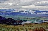
Because Eastern California is generally in the rain shadow of the Sierra Nevada or the Transverse Ranges
, the climate is extremely dry and can be considered a desert
. Indeed, the hottest and lowest area in North America
lies in Eastern California: Death Valley
.
Geologically, Eastern California is mostly part of the Basin and Range Province, marked by crustal extension, with horsts and graben
s. Volcanism is also very evident in this region.
California
California is a state located on the West Coast of the United States. It is by far the most populous U.S. state, and the third-largest by land area...
, United States
United States
The United States of America is a federal constitutional republic comprising fifty states and a federal district...
. It can refer to either the strip to the east of the crest of the Sierra Nevada, or to the easternmost counties of California.
Culture and history
Most of Eastern California does not fit the stereotypes of California, and is more related in culture to southeastern OregonOregon
Oregon is a state in the Pacific Northwest region of the United States. It is located on the Pacific coast, with Washington to the north, California to the south, Nevada on the southeast and Idaho to the east. The Columbia and Snake rivers delineate much of Oregon's northern and eastern...
and northwestern Nevada
Nevada
Nevada is a state in the western, mountain west, and southwestern regions of the United States. With an area of and a population of about 2.7 million, it is the 7th-largest and 35th-most populous state. Over two-thirds of Nevada's people live in the Las Vegas metropolitan area, which contains its...
. Eastern California is very sparsely populated (except for the area around Lake Tahoe
Lake Tahoe
Lake Tahoe is a large freshwater lake in the Sierra Nevada of the United States. At a surface elevation of , it is located along the border between California and Nevada, west of Carson City. Lake Tahoe is the largest alpine lake in North America. Its depth is , making it the USA's second-deepest...
), and tends to be politically conservative
Conservatism
Conservatism is a political and social philosophy that promotes the maintenance of traditional institutions and supports, at the most, minimal and gradual change in society. Some conservatives seek to preserve things as they are, emphasizing stability and continuity, while others oppose modernism...
, much like the rest of the rural Western United States
Western United States
.The Western United States, commonly referred to as the American West or simply "the West," traditionally refers to the region comprising the westernmost states of the United States. Because the U.S. expanded westward after its founding, the meaning of the West has evolved over time...
. However, the counties of San Bernardino
San Bernardino County, California
San Bernardino County is a county in the U.S. state of California. As of the 2010 census, the population was 2,035,210, up from 1,709,434 as of the 2000 census...
and Riverside
Riverside County, California
Riverside County is a county in the U.S. state of California. One of 58 California counties, it covers in the southern part of the state, and stretches from Orange County to the Colorado River, which forms the state border with Arizona. The county derives its name from the city of Riverside,...
are part of the Greater Los Angeles
Greater Los Angeles Area
The Greater Los Angeles Area, or the Southland, is a term used for the Combined Statistical Area sprawled over five counties in the southern part of California, namely Los Angeles County, Orange County, San Bernardino County, Riverside County and Ventura County...
area and the counties of El Dorado
El Dorado County, California
El Dorado County is a county located in the historic Gold Country in the Sierra Nevada Mountains and foothills of the U.S. state of California. The 2010 population was 181,058. The El Dorado county seat is in Placerville....
, Placer
Placer County, California
Placer County is a county located in both the Sacramento Valley and Sierra Nevada regions of the U.S. state of California, in what is known as the Gold Country. It stretches from the suburbs of Sacramento to Lake Tahoe and the Nevada border. Because of the expansion of the Greater Sacramento,...
and Nevada
Nevada County, California
Nevada County is a county located in the Sierra Nevada of California, in the Mother Lode country. As of 2010 its population was 98,764. The county seat is Nevada City.-History:Nevada County was created in 1851 from parts of Yuba County....
are part of the Greater Sacramento area and are culturally influenced by their respective metropolitan areas.
Historically, Eastern California has had strong ties to Nevada, with the exact boundary between the two states in some dispute. Residents of portions of near Susanville, California
Susanville, California
Susanville is the county seat of Lassen County, California, United States. Susanville is located on the Susan River in the south-central part of the county, at an elevation of 4186 feet . The population was 17,974 at the 2010 census, up from 13,541 at the 2000 census...
tried to break away from California in 1856, first by declaring themselves part of the Nataqua Territory
Nataqua Territory
The Nataqua Territory was a short lived and unofficial territory of the United States. It consisted of a portion of what is now northeastern California and northwestern Nevada, centered on Susanville, California. In 1856, the border between California and the Utah Territory was unsurveyed and...
, and then through annexation to Nevada. The two states further squabbled over ownership of Susanville in 1863. The town of Aurora, Nevada
Aurora, Nevada
Aurora is a ghost town in Mineral County in the western central part of the U.S. state of Nevada, approximately southwest of the town of Hawthorne and three miles from the California border....
was temporarily the county seat of both Mono County, California
Mono County, California
Mono County is a county located in the east central portion of the U.S. state of California, to the east of the Sierra Nevada between Yosemite National Park and Nevada. As of the 2010 census, the population was 14,202, up from 12,853 at the 2000 census...
and Esmeralda County, Nevada
Esmeralda County, Nevada
Esmeralda County is a county in the west of U.S. state of Nevada. Its county seat is Goldfield. Its 2000 census population was officially 971, making its population density 0.1045 inhabitants/km² , the second-lowest of any county-equivalent outside of Alaska. As of 2010, the population had...
. Finally, the line between the two states was settled by a survey in 1872.
Geography and geology
The easternmost counties of California are:- Modoc CountyModoc County, CaliforniaModoc County is a county located in the far northeast corner of the U.S. state of California, bounded by the state of Oregon to the north and the state of Nevada to the east. As of the 2010 census, its population was 9,686, up from 9,449 at the 2000 census. The current county seat is Alturas, the...
- Lassen CountyLassen County, CaliforniaLassen County is a county located in the northeastern portion of the U.S. state of California. As of the 2010 census, the population was 34,895, up from 33,828 at the 2000 census...
- Plumas CountyPlumas County, CaliforniaPlumas County is a county located in the Sierra Nevada of the U.S. state of California. The county gets its name from the Spanish words for the Feather River , which flows through the county. As of the 2010 census, the population 20,007, down from 20,824 at the 2000 census...
- Sierra CountySierra County, CaliforniaSierra County is a county located in the Sierra Nevada of the U.S. state of California, northeast of Sacramento on the border with Nevada. As of the 2010 census the population was 3,240, down from 3,555 at the 2000 census. The county seat is Downieville....
- Nevada CountyNevada County, CaliforniaNevada County is a county located in the Sierra Nevada of California, in the Mother Lode country. As of 2010 its population was 98,764. The county seat is Nevada City.-History:Nevada County was created in 1851 from parts of Yuba County....
- Placer CountyPlacer County, CaliforniaPlacer County is a county located in both the Sacramento Valley and Sierra Nevada regions of the U.S. state of California, in what is known as the Gold Country. It stretches from the suburbs of Sacramento to Lake Tahoe and the Nevada border. Because of the expansion of the Greater Sacramento,...
- El Dorado CountyEl Dorado County, CaliforniaEl Dorado County is a county located in the historic Gold Country in the Sierra Nevada Mountains and foothills of the U.S. state of California. The 2010 population was 181,058. The El Dorado county seat is in Placerville....
- Alpine CountyAlpine County, CaliforniaAlpine County is the smallest county, by population, in the U.S. state of California. As of 2010, it had a population of 1,175, all rural. There are no incorporated cities in the county. The county seat is Markleeville...
- Mono CountyMono County, CaliforniaMono County is a county located in the east central portion of the U.S. state of California, to the east of the Sierra Nevada between Yosemite National Park and Nevada. As of the 2010 census, the population was 14,202, up from 12,853 at the 2000 census...
- Inyo CountyInyo County, California-National protected areas:* Death Valley National Park * Inyo National Forest * Manzanar National Historic Site-Major highways:* U.S. Route 6* U.S. Route 395* State Route 127* State Route 136* State Route 168* State Route 178...
- San Bernardino CountySan Bernardino County, CaliforniaSan Bernardino County is a county in the U.S. state of California. As of the 2010 census, the population was 2,035,210, up from 1,709,434 as of the 2000 census...
- Riverside CountyRiverside County, CaliforniaRiverside County is a county in the U.S. state of California. One of 58 California counties, it covers in the southern part of the state, and stretches from Orange County to the Colorado River, which forms the state border with Arizona. The county derives its name from the city of Riverside,...
- Imperial CountyImperial County, CaliforniaImperial County is a county located in the Imperial Valley, in the far southeast of the U.S. state of California, bordering both Arizona and Mexico. It is part of the El Centro Metropolitan Area, which encompasses all of Imperial County. The population as of 2000 was 142,361. The county seat is the...
Because Eastern California is generally in the rain shadow of the Sierra Nevada or the Transverse Ranges
Transverse Ranges
The Transverse Ranges are a group of mountain ranges of southern California, in the Pacific Coast Ranges physiographic region that runs along the Pacific coast from Alaska to Mexico in North America. The Transverse Ranges begin at the southern end of the California Coast Ranges and lie between...
, the climate is extremely dry and can be considered a desert
Desert
A desert is a landscape or region that receives an extremely low amount of precipitation, less than enough to support growth of most plants. Most deserts have an average annual precipitation of less than...
. Indeed, the hottest and lowest area in North America
North America
North America is a continent wholly within the Northern Hemisphere and almost wholly within the Western Hemisphere. It is also considered a northern subcontinent of the Americas...
lies in Eastern California: Death Valley
Death Valley
Death Valley is a desert valley located in Eastern California. Situated within the Mojave Desert, it features the lowest, driest, and hottest locations in North America. Badwater, a basin located in Death Valley, is the specific location of the lowest elevation in North America at 282 feet below...
.
Geologically, Eastern California is mostly part of the Basin and Range Province, marked by crustal extension, with horsts and graben
Graben
In geology, a graben is a depressed block of land bordered by parallel faults. Graben is German for ditch. Graben is used for both the singular and plural....
s. Volcanism is also very evident in this region.