

U.S. Route 395 in California
Encyclopedia
In the U.S. state
of California
, U.S. Route 395 (US 395) is a 557 miles (896.4 km) route which traverses from Interstate 15
near the southern city limits of Hesperia
, north to the Oregon
state line in Modoc County
near Goose Lake
. The route clips into Nevada
, serving the cities Carson City
and Reno
, before returning to California.
Prior to truncation, US 395 served the metropolitan
areas of San Diego and San Bernardino
. The highway serves as a connection to the Los Angeles
area for the communities of the Owens Valley
, Mammoth Lakes and Mono Lake
. The highway is used as an access for both the highest point in the contiguous United States
, Mount Whitney
, and the lowest point in North America, Death Valley
.
The corridor has been used since the California gold rush
, and before numbering was known by several names including El Camino Sierra
. This route is part of the California Freeway and Expressway System
and is eligible for the Scenic Highway system
.
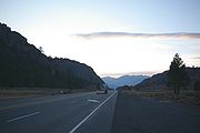
 The route of US 395 in California is split into two segments, as the highway exits and reenters California. The southern segment crosses the Mojave Desert
and Owens Valley
and passes east of the Sierra Nevada. The northern segment also follows the Sierra Nevada and crosses the Modoc Plateau
.
at a partial interchange with Interstate 15
as it heads north. The road enters into Adelanto
, on the western edge of Victorville
. Victorville, founded by the Santa Fe Railroad to take advantage of water along the Mojave River
, and for most of its history home to George Air Force Base
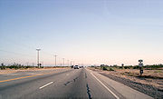
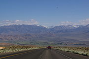
, was the second fastest growing city in the United States for July 2006 to July 2007. Although US 395 was once a rural road passing to the side of these cities, with growth these cities are encroaching on the highway and changing the character from rural to suburban.
 After leaving the Victorville area the scenery changes, as suburban neighborhoods disappear and the highway traverses the Mojave Desert. While crossing the desert, the route clips the northeastern corner of Edwards Air Force Base
. Just past the base the road intersects SR 58
at Kramer Junction
. This is currently an at-grade intersection
; however, SR 58 is gradually being upgraded to a freeway. After leaving Kramer Junction 395 passes the Kramer Junction Solar Electric Generating Station. US 395 crosses the Rand
and El Paso Mountains
, where the highway crosses into San Bernardino
–Kern
county line, near Johannesburg
. While traversing these mountains the route crosses a former Southern Pacific rail line, now owned by the Union Pacific Railroad
(UP) that loosely follows the route of State Route 14
through the Mojave. Though the railroad is abandoned north of Searles
Station, US 395 parallels the old railroad grade from this point to Lone Pine
.
On the other side of the mountains is Indian Wells Valley, US 395 passes between the cities of Ridgecrest
and Inyokern, where US 395 Bus. is located and is routed on South China Boulevard.
US 395 follows the western boundary of the Naval Air Weapons Station China Lake
, not far from Big and Little Petroglyph Canyons
, where Coso People
created prolific rock art
and traded with distant tribes using tools crafted of stone. The highway proceeds diagonally across the valley, until merging with State Route 14. Prior to July 1, 1964, the part State Route 14 between Interstate 5 and US 395 was part of US 6
that continued south to Long Beach
.
Between Mojave
and its junction with Route 395, Route 14 follows the edge of the Sierra Nevada mountains. Formerly US 6 and US 395 ran concurrent
from this junction north to Bishop. US 395 follows the valleys along the eastern edge of the Sierra as the mountains gradually increase in altitude until reaching their peak at over 14000 feet (4,267.2 m) near Lone Pine
. After passing by three small lakes, Little Lake, North and South Haiwee Reservoirs, the highway enters the Owens Valley
.
. The valley, named for one of explorer John C. Fremont
's guides, was primarily home to Timbisha
and Paiute
s before European settlement. Formerly a fertile lake and valley, Owens Lake and the southern portion of the valley are now dry. Water from the valley is channeled for use by the City of Los Angeles
, via the Los Angeles Aqueduct
, in what is commonly called the California Water Wars
.
 Along the shores of Owens Lake, the highway passes by Cartago
and Olancha
. Just north of the lake is Lone Pine
. Lone Pine is noted as an access for both the highest point in the contiguous United States
, Mount Whitney
, and the lowest point in North America, Death Valley
. Both Mount Whitney and the mountains surrounding Death Valley are visible from US 395. From Lone Pine to Bishop, the US 395 corridor loosely follows another abandoned rail line, the Carson and Colorado Railroad
, although for most of this run the rail line runs on the eastern edge of the valley, while the road mostly runs on the west edge. The US 395 corridor from Lone Pine north to the Nevada state line is noted for a high concentration of natural hot spring
s leading to area being known as the "hot springs jackpot".
Past Lone Pine, the highway passes by Manzanar
National Historic Site, a concentration camp where Japanese American
s were imprisoned during World War II
. The next community is Independence
, the county seat
of Inyo County
and the home to the Eastern California Museum. Just north is the small Fort Independence Indian Reservation and the Tinemaha Reservoir. Nearby is where the Los Angeles Aqueduct is tapped from the Owens River
; with more vegetation visible north of this point. In this portion of the valley is Big Pine
and the Big Pine Indian Reservation. From here to Bishop the highway is overlapped with SR 168
.
At the north end of the valley sits Bishop
, the largest city in the Owens Valley. Bishop serves as a gateway for the recreation areas of the Sierra Nevada, including Mammoth Mountain
. At the north end of Bishop is the former separation with, and current terminus of, U.S. Route 6
, a 3205 miles (5,157.9 km) route which can take motorists ultimately to Provincetown, Massachusetts
on the east coast
. This point is also where the route of US 395 departs from former rail corridors, with the former Carson and Colorado grade following the modern US 6 corridor towards Hawthorne
and Tonopah, Nevada
.
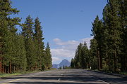
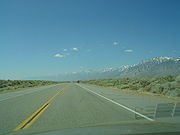
The scenery changes dramatically past Bishop as the highway reaches the end of the valley and with a single ascent, gains over 3000 feet (914.4 m) in elevation. From here to Gardnerville
, the highway is routed across spur ranges of the Sierra Nevada mountains.
 US 395 scales the Sierra Nevada on a ridge between the canyons of the Owens River and Rock Creek. Sherwin Summit
, at 7000 feet (2,133.6 m), is the first of five mountain pass
es crossed by US 395 in the Sierra Nevada. The highway enters Mono County
midway up the ascent, called the Sherwin Grade.
After cresting Sherwin Summit, the highway travels along the west shore of Crowley Lake
. Crowley Lake is a reservoir for the City of Los Angeles's
acqueduct, supplied by the Owens River. However US 395 does not resume following the river, instead cutting across the Long Valley Caldera
to serve the ski resort area of Mammoth Lakes
and Mammoth Mountain
via SR 203
, after paralleling the runway of the Mammoth Yosemite Airport
.
Eight miles past the junction leading to Mammoth, the highway crests the second summit, Deadman Summit
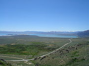
, at 8036 feet (2,449.4 m). This summit separates the Owens River watershed from that of Mono Lake
, a salt lake with approximately three times the concentration of salt as the Ocean.
Along the descent towards Mono Lake, the highway passes near the community of June Lake
, a recreation area where there are several freshwater lakes famous for trout fishing, and the June Mountain Ski Area
. The June Lake area is served from June Lake Junction
by the June Lake Loop Road (SR 158)
Just before arriving at Mono Lake, US 395 has a brief concurrency with SR 120
; the two routes separate at the southern end of Lee Vining
. At this junction US 395 is 12 miles (19.3 km) from Tioga Pass
, along route 120, the highest paved route in California, and the eastern boundary of Yosemite National Park
.
 Visible for miles, the highway finally passes Mono Lake, squeezed between the lake and the Sierra crest. The next geographic feature is Conway Summit
. At 8138 feet (2,480.5 m) in altitude, this is the highest point along US 395, and the highest point along a U.S. Highway in California. This Summit also separates the Mono Lake watershed from that of the East Walker River
.
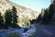
The highway descends Conway Summit via the tributaries of the East Walker River
, heading towards Bridgeport
and Bridgeport Reservoir. Along the descent the highway passes by Bodie
, a ghost town
which the state park system has preserved, including items still on the shelves in the abandoned stores.
The fourth summit crossed by US 395 in California is Devil's Gate Pass
, elevation 7519 feet (2,291.8 m), which separates the East and West Walker
Rivers. The winding descent from Devil's Gate follows the West Walker River, exiting near the towns of Walker
and Coleville
in the Antelope Valley, a few miles south of Topaz Lake
which is on the California-Nevada State Line.
Topaz Lake is where US 395 leaves California, to serve the Reno
and Carson City
metropolitan areas. The highway runs for 87 miles (140 km) in Nevada. While in Nevada, the highway crosses one more pass, Simee Dimeh Summit, before exiting the mountains. The highway returns to follow the receding escarpment
of the sierra.
just past the state line. The road follows Long Valley Creek along the edge of the sierra towards Honey Lake
. From this point north, the highway follows a rail line originally built by the Nevada-California-Oregon Railway
; the line is now owned by the Union Pacific Railroad
.
 The highway enters the state in a corner of Sierra County
, entering Lassen County
just 3 miles (4.8 km) later. A short segment in Lassen County is a freeway with one exit, SR 70
at the Hallelujah Junction
. This exit is numbered 8, even though it resides hundreds of miles from the origin of the highway; the exit number instead uses the distance from the point of re-entry to California. Though SR 70 does not directly serve any major cities, the highway is noted as an all-weather crossing of the Sierras. Just less than 5 miles (8 km) from Hallelujah Junction is Beckwourth Pass
, the lowest pass in the Sierra, used by both SR 70 and the Feather River Route
. SR 70 was at one time numbered U.S. Route 40 Alternate, using US 395 from this junction south to Reno
to connect with the mainline US 40 (now Interstate 80). Though driving route 70 and US 395 is a much longer route between Reno and Sacramento
than mainline US 40 (130 miles (209.2 km) versus 226 miles (363.7 km)), the alternate route was more likely to be open during winter storms than US 40, which crested the sierra at Donner Pass
.
The highway proceeds towards and around the west side of 73 mi2 Honey Lake
while en route to Susanville
. Although Susanville is used as a control city
, US 395 does not technically enter the city. In a T-intersection with State Route 36
just before Susanville, US 395 makes a sharp turn avoiding the city, making a near complete loop around the Susanville Municipal Airport
.
 North of Susanville, the highway bends around Shaffer Mountain and crosses the Modoc Plateau
. While en route, the highway serves the towns of Ravendale
, Termo
,and Madeline
in Lassen County
, as well as Likely
in Modoc County
. Here US 395 parallels the South Fork of the Pit River
until the confluence with the north fork in Alturas
. Past the confluence, the highway follows North Fork Pit River across Modoc County toward Goose Lake
. The last junction in California is with SR 299
, former U.S. Route 299, in Alturas
. SR 299 can be used to travel west all the way to the western side of California at US 101 in Arcata
, and east to Nevada State Route 8A
at the Nevada state line. The two highways are briefly concurrent from Alturas to the XL Ranch Indian Reservation. US 395 travels in a north-northeast direction for some last 50 miles (80.5 km) in California, paralleling the east shore of Goose Lake just before crossing the Oregon
state line at New Pine Creek, Oregon
.
loosely paralleling modern State Route 14, US 395, and State Route 89. The trail was first believed to be used by Jedediah Smith
in 1826. The trail was in common use by prospectors passing through the area because of the California gold rush
and Comstock Lode
. Though this area was not directly affected by the gold and silver rushes, the Owens Valley was more fertile than the areas around the strikes in Nevada. Farmers and ranchers raised cattle and other goods to trade with the mining boom towns nearby. The town of Bishop was established to trade goods with the mining town of Aurora
. By 1860, the Camino Sierra was an established trail appearing in maps and guides. After these mining rushes died down, the Camino Sierra saw a revival because of the construction of the Los Angeles Aqueduct
beginning in 1908. The route was promoted for its scenic value by the Southern Pacific Railroad
, as a side trip from its rail lines, as far back as 1912. By 1918, the Camino Sierra had been included in the Blue Book, an early road atlas of the United States.
in Nevada. Both lines where intended to connect the main Southern Pacific Railroad
line in Nevada with other lines, but were never completed.
 On May 20, 1880 the Carson and Colorado Railway was formed, with the intent of extending a rail line from the existing Virginia and Truckee Railroad
at Hawthorne, Nevada
through the Owens Valley towards the Colorado River
. Though the rail line was never finished, it did bring economic development to the valley. The railroad was never completed past Keeler
on the shores of Owens Lake. This line was acquired by the Southern Pacific Railroad
in 1900. There were plans to connect this narrow gauge line with SP's standard gauge lines in the area, however these plans never materialized and the narrow gauge line was scrapped in 1959.
The corridor for the northern segment was first used by the Nevada-California-Oregon Railway
, a line also started in 1880, at Reno, to connect with the Great Northern Railway in Oregon. This line also was never completed, ending at Lakeview, Oregon
. This line is still active, through a series of acquisitions, the Union Pacific Railroad
now owns this line. The portion from Reno to Hallelujah Junction
is used as a connection between the Union Pacific's two main lines in northern California/Nevada, the Overland Route (First Transcontinental Railroad) and the Feather River Route
.
 As first commissioned in 1926, US 395 was a minor spur route of U.S. Route 195
connecting Spokane, Washington
with Canada
. During the 1930s, US 395 was extended from Spokane to San Diego
, over the Camino Sierra, using several existing state routes. The extension first appeared on the Official Nevada Highway map in 1935. By 1937, US 6 had been extended to California, concurrent
with US 395 between Bishop and Inyokern.
The new southern terminus of US 395 was at Pacific Highway (former US 101) in San Diego. Traveling north, US 395 traversed much of the path of modern SR 163 and I-15
to Poway Road, where it routed to the east along much of today's Pomerado Road to Lake Hodges, with various realignments over the years. Portions of Pomerado Road today are signed "Historic US 395". At Lake Hodges the highway crossed a now-replaced bridge to Escondido
.
Past Escondido the route passed through Fallbrook
using portions of what is now SR 78
and SR 76
before returning to I-15 near Temecula
. This portion was straightened to the route of modern I-15, by 1960. Past Temecula, the route followed SR 79
, SR 74
, I-215
and I-15 until reaching the modern terminus in Hesperia
. This part would also be straightened with the construction of what is now I-215. In 1969, the portion south of Hesperia was removed and assigned to other routes.
Over time the road was paved, upgraded and straightened. Some parts are now built to freeway standards. Among the more notable upgrades, the Los Peñasquitos Creek Arch Bridge
, along the portion of former US 395 now used by I-15, was built in 1949, and replaced in 1964, with a second span built in 1977. Today, US 395 is part of the California Freeway and Expressway System
and is eligible for the State Scenic Highway System
.
{| class=wikitable
!County
!Location
!Postmile
!Exit
!Destinations
!Notes
|-
|rowspan=6|San Bernardino
SBD R3.98-73.52
|rowspan=3|Hesperia
|bgcolor=#ffdddd|R3.98
|bgcolor=#ffdddd|
|bgcolor=#ffdddd|
|bgcolor=#ffdddd|Interchange; southbound exit and northbound entrance; former US 395 south
|-
|
|
|.svg.png) Joshua Street to I-15 north – Victorville
Joshua Street to I-15 north – Victorville
|
|-
|R5.61
|
|Main Street, Phelan Road – Phelan
|
|-
|Adelanto
|11.18
|
|
|
|-
|Kramer Junction
|45.95
|
|
|Former US 466
|-
|
|72.77
|
|Trona Road – Trona, Death Valley
|
|-
|rowspan=6|Kern
KER 0.00-R36.82
|
|R1.15
|
|Redrock Randsburg Road – Randsburg
|
|-
|
|R15.00
|
|China Lake Boulevard (US 395 Bus. north), Brown Road – Ridgecrest
, China Lake NAWS
|China Lake Boulevard serves Cerro Coso Community College
; Brown Road was former US 395 north
|-
|
|R23.48
|
|
|Interchange
|-
|
|bgcolor=#ffdddd|R25.08
|bgcolor=#ffdddd|
|bgcolor=#ffdddd|Brown Road – Inyokern
|bgcolor=#ffdddd|Interchange; southbound exit and northbound entrance; former US 395
|-
|
|bgcolor=#ffdddd|R29.64
|bgcolor=#ffdddd|
|bgcolor=#ffdddd|
|bgcolor=#ffdddd|Interchange; southbound exit and northbound entrance; former US 6
south
|-
|
|
|
|Brown Road
|Former US 395 south
|-
|rowspan=6|Inyo
INY R0.00-R129.46
|
|
|
|Nine Mile Canyon Road (CR J41) – Kennedy Meadows
|
|-
|Olancha
|34.67
|
|
|
|-
|Lone Pine
|55.83
|
|
|
|-
|Big Pine
|bgcolor=#ddffdd|100.83
|bgcolor=#ddffdd|
|bgcolor=#ddffdd|
|bgcolor=#ddffdd|South end of SR 168 overlap
|-
|rowspan=2|Bishop
|bgcolor=#ddffdd|115.40
|bgcolor=#ddffdd|
|bgcolor=#ddffdd|
|bgcolor=#ddffdd|North end of SR 168 overlap; East Line Street serves Eastern Sierra Regional Airport
|-
|116.25
|
| – Tonopah
|
|-
|rowspan=14|Mono
MNO R0.00-120.49
|Tom's Place
|R10.26
|
|Crowley Lake Drive, Owens Gorge Road – Rock Creek Lake
|
|-
|
|R13.93
|
|Crowley Lake
, Hilton Creek
|Interchange
|-
|
|
|
|
.svg.png) Benton Crossing Road to SR 120
Benton Crossing Road to SR 120
/ US 6
– Owens River
, Benton
|
|-
|
|R25.75
|
|
|Interchange
|-
|June Lake Junction
|40.34
|
|
|
|-
|
|bgcolor=#ddffdd|45.96
|bgcolor=#ddffdd|
|bgcolor=#ddffdd|, Mono Lake South Tufa
|bgcolor=#ddffdd|South end of SR 120 overlap
|-
|
|46.40
|
|
|
|-
|Lee Vining
|bgcolor=#ddffdd|50.74
|bgcolor=#ddffdd|
|bgcolor=#ddffdd|
|bgcolor=#ddffdd|North end of SR 120 overlap
|-
|
|58.24
|
| – Hawthorne
, Lundy Lake
|
|-
|
|69.85
|
|
|
|-
|Bridgeport
|76.30
|
| – Bridgeport Lake
, Yerington
|
|-
|Sonora Junction
|93.70
|
| – Marine Corps Training Center
, Sonora
|
|-
|
|116.96
|
| – Monitor Pass
, Markleeville
|
|-
|
|120.49
|colspan=3 align=center|Nevada state line
|-
!colspan=6|US 395 exits and reenters California via Nevada
|-
|rowspan=2|Sierra
SIE R0.00-R3.12
|
|R0.00
|colspan=3 align=center|Nevada state line
|-
|colspan=5 align=center|No junctions
|-
|rowspan=9|Lassen
LAS R0.00-138.98
|-
|Hallelujah Junction
|4.62
|8
|
|Interchange
|-
|
|29.84
|
|, Sierra Army Depot
|
|-
|
|
|
|
|
|-
|
|51.87
|
|, Lakeview
|
|-
|
|R61.09
|
|
|
|-
|Standish
|70.12
|
| – Reno
|
|-
|Litchfield
|72.94
|
| – High Desert State Prison
|
|-
|Madeline
|129.19
|
|Ash Valley Road – Adin
|
|-
|rowspan=4|Modoc
MOD 0.06-61.56
|Alturas
|bgcolor=#ddffdd|22.76
|bgcolor=#ddffdd|
|bgcolor=#ddffdd|, Klamath Falls
|bgcolor=#ddffdd|South end of SR 299 overlap
|-
|
|bgcolor=#ddffdd|28.29
|bgcolor=#ddffdd|
|bgcolor=#ddffdd|, Gerlach
|bgcolor=#ddffdd|North end of SR 299 overlap
|-
|
|
|
|Fandango Pass Road – Fort Bidwell
, Willow Ranch
|
|-
|New Pine Creek
|61.56
|colspan=3 align=center|Oregon state line
U.S. state
A U.S. state is any one of the 50 federated states of the United States of America that share sovereignty with the federal government. Because of this shared sovereignty, an American is a citizen both of the federal entity and of his or her state of domicile. Four states use the official title of...
of California
California
California is a state located on the West Coast of the United States. It is by far the most populous U.S. state, and the third-largest by land area...
, U.S. Route 395 (US 395) is a 557 miles (896.4 km) route which traverses from Interstate 15
Interstate 15 in California
In the U.S. state of California, Interstate 15 is a major north–south route through the San Bernardino, Riverside, and San Diego Counties, and it has a length of in the state. It is a major thoroughfare for traffic between Southern California and Las Vegas, Nevada, as well as points beyond...
near the southern city limits of Hesperia
Hesperia, California
Hesperia is a city in San Bernardino County, California, United States. It is located in the Mojave Desert north of San Bernardino. The locals refer to the surrounding area as the High Desert...
, north to the Oregon
Oregon
Oregon is a state in the Pacific Northwest region of the United States. It is located on the Pacific coast, with Washington to the north, California to the south, Nevada on the southeast and Idaho to the east. The Columbia and Snake rivers delineate much of Oregon's northern and eastern...
state line in Modoc County
Modoc County, California
Modoc County is a county located in the far northeast corner of the U.S. state of California, bounded by the state of Oregon to the north and the state of Nevada to the east. As of the 2010 census, its population was 9,686, up from 9,449 at the 2000 census. The current county seat is Alturas, the...
near Goose Lake
Goose Lake (Oregon-California)
Goose Lake is a large alkaline glacial lake located in the Goose Lake Valley on the Oregon-California border. The north end of the lake is in Lake County, Oregon and the south end is in Modoc County, California. The mountains at the north end of the lake are part of the Fremont National Forest...
. The route clips into Nevada
Nevada
Nevada is a state in the western, mountain west, and southwestern regions of the United States. With an area of and a population of about 2.7 million, it is the 7th-largest and 35th-most populous state. Over two-thirds of Nevada's people live in the Las Vegas metropolitan area, which contains its...
, serving the cities Carson City
Carson City, Nevada
The Consolidated Municipality of Carson City is the capital of the state of Nevada. The words Consolidated Municipality refer to a series of changes in 1969 which abolished Ormsby County and merged all the settlements contained within its borders into Carson City. Since that time Carson City has...
and Reno
Reno, Nevada
Reno is the county seat of Washoe County, Nevada, United States. The city has a population of about 220,500 and is the most populous Nevada city outside of the Las Vegas metropolitan area...
, before returning to California.
Prior to truncation, US 395 served the metropolitan
Metropolitan area
The term metropolitan area refers to a region consisting of a densely populated urban core and its less-populated surrounding territories, sharing industry, infrastructure, and housing. A metropolitan area usually encompasses multiple jurisdictions and municipalities: neighborhoods, townships,...
areas of San Diego and San Bernardino
San Bernardino, California
San Bernardino is a city located in the Riverside-San Bernardino metropolitan area , and serves as the county seat of San Bernardino County, California, United States...
. The highway serves as a connection to the Los Angeles
Los Ángeles
Los Ángeles is the capital of the province of Biobío, in the commune of the same name, in Region VIII , in the center-south of Chile. It is located between the Laja and Biobío rivers. The population is 123,445 inhabitants...
area for the communities of the Owens Valley
Owens Valley
Owens Valley is the arid valley of the Owens River in eastern California in the United States, to the east of the Sierra Nevada and west of the White Mountains and Inyo Mountains on the west edge of the Great Basin section...
, Mammoth Lakes and Mono Lake
Mono Lake
Mono Lake is a large, shallow saline lake in Mono County, California, formed at least 760,000 years ago as a terminal lake in a basin that has no outlet to the ocean...
. The highway is used as an access for both the highest point in the contiguous United States
Contiguous United States
The contiguous United States are the 48 U.S. states on the continent of North America that are south of Canada and north of Mexico, plus the District of Columbia....
, Mount Whitney
Mount Whitney
Mount Whitney is the highest summit in the contiguous United States with an elevation of . It is on the boundary between California's Inyo and Tulare counties, west-northwest of the lowest point in North America at Badwater in Death Valley National Park...
, and the lowest point in North America, Death Valley
Death Valley
Death Valley is a desert valley located in Eastern California. Situated within the Mojave Desert, it features the lowest, driest, and hottest locations in North America. Badwater, a basin located in Death Valley, is the specific location of the lowest elevation in North America at 282 feet below...
.
The corridor has been used since the California gold rush
California Gold Rush
The California Gold Rush began on January 24, 1848, when gold was found by James W. Marshall at Sutter's Mill in Coloma, California. The first to hear confirmed information of the gold rush were the people in Oregon, the Sandwich Islands , and Latin America, who were the first to start flocking to...
, and before numbering was known by several names including El Camino Sierra
Sierra Highway
Sierra Highway or El Camino Sierra is a road in Southern California, United States. El Camino Sierra refers to the full length of a trail formed in the 19th century, rebuilt as highways in the early 20th century, that ran from Los Angeles to Lake Tahoe following parts of modern State Route 14, U.S....
. This route is part of the California Freeway and Expressway System
California Freeway and Expressway System
The California Freeway and Expressway System is a system of existing or planned freeways and expressways in the U.S. state of California. It is defined by the Streets and Highways Code.-List of roads in the system:*State Route 1 *State Route 2...
and is eligible for the Scenic Highway system
State Scenic Highway System (California)
The State Scenic Highway System is a list of highways, mainly state highways, that have been designated by the California Department of Transportation as scenic highways. The California State Legislature, primarily through Section 263 of the Streets and Highways Code, makes highways eligible for...
.
Route description
Mojave Desert
The Mojave Desert occupies a significant portion of southeastern California and smaller parts of central California, southern Nevada, southwestern Utah and northwestern Arizona, in the United States...
and Owens Valley
Owens Valley
Owens Valley is the arid valley of the Owens River in eastern California in the United States, to the east of the Sierra Nevada and west of the White Mountains and Inyo Mountains on the west edge of the Great Basin section...
and passes east of the Sierra Nevada. The northern segment also follows the Sierra Nevada and crosses the Modoc Plateau
Modoc Plateau
The Modoc Plateau lies in the northeast corner of California as well as parts of Oregon and Nevada. It is a mile-high expanse of lava flows with cinder cones, juniper flats, pine forests, and seasonal lakes. The plateau is thought to have been formed approximately 25 million years ago...
.
Mojave Desert
U.S. Route 395 begins in HesperiaHesperia, California
Hesperia is a city in San Bernardino County, California, United States. It is located in the Mojave Desert north of San Bernardino. The locals refer to the surrounding area as the High Desert...
at a partial interchange with Interstate 15
Interstate 15 in California
In the U.S. state of California, Interstate 15 is a major north–south route through the San Bernardino, Riverside, and San Diego Counties, and it has a length of in the state. It is a major thoroughfare for traffic between Southern California and Las Vegas, Nevada, as well as points beyond...
as it heads north. The road enters into Adelanto
Adelanto, California
Adelanto is a city in San Bernardino County, California about northwest of Victorville. The population was 31,765 at the 2010 census, up from 18,130 at the 2000 census.-Name:...
, on the western edge of Victorville
Victorville, California
Victorville is a city located in the Victor Valley of southwestern San Bernardino County, California. According to the U.S. Census Bureau's 2010 census, the city had a population of 115,903, up from 64,030 at the 2000 census.-Geography and climate:...
. Victorville, founded by the Santa Fe Railroad to take advantage of water along the Mojave River
Mojave River
The Mojave River is an intermittent river in the eastern San Bernardino Mountains and Mojave Desert in San Bernardino County, California. The river is notable as most of its flow is underground, while its surface channels remain dry most of the time, with the exception of the headwaters and several...
, and for most of its history home to George Air Force Base
George Air Force Base
George Air Force Base is a former United States Air Force base located within city limits, 8 miles northwest of central Victorville, California, about 75 miles northeast of Los Angeles, California. The facility was closed by the Base Realignment and Closure 1992 commission at the end of the Cold...
, was the second fastest growing city in the United States for July 2006 to July 2007. Although US 395 was once a rural road passing to the side of these cities, with growth these cities are encroaching on the highway and changing the character from rural to suburban.
Edwards Air Force Base
Edwards Air Force Base is a United States Air Force base located on the border of Kern County, Los Angeles County, and San Bernardino County, California, in the Antelope Valley. It is southwest of the central business district of North Edwards, California and due east of Rosamond.It is named in...
. Just past the base the road intersects SR 58
California State Route 58
State Route 58 is an east-west highway across the California Coast Ranges, the southern San Joaquin Valley, the Tehachapi Mountains, which border the southern Sierra Nevada, and the Mojave Desert. It runs between its western terminus near Santa Margarita and its eastern terminus at Barstow...
at Kramer Junction
Kramer Junction, California
Kramer Junction is a small community in the Mojave Desert at the intersection of U.S. Route 395 and State Route 58.Solar Energy Generating Systems sites SEGS III-VII are located less than a mile to the northwest....
. This is currently an at-grade intersection
At-grade intersection
An at-grade intersection is a junction at which two or more transport axes cross at the same level .-Traffic management:With areas of high or fast traffic, an at-grade intersection normally requires a traffic control device such as a stop sign, traffic light or railway signal to manage conflicting...
; however, SR 58 is gradually being upgraded to a freeway. After leaving Kramer Junction 395 passes the Kramer Junction Solar Electric Generating Station. US 395 crosses the Rand
Rand Mountains
The Rand Mountains are located in the Mojave Desert northeast of California City, California and southwest of the town of Randsburg, California.-History:...
and El Paso Mountains
El Paso Mountains
The El Paso Mountains are located in central southern California in the United States. The range lies in a southwest-northeasterly direction east of Highway 14, and north of the Rand Mountains and Randsburg Red Rock Road. Red Rock Canyon State Park lies at the western end of the range.The mountains...
, where the highway crosses into San Bernardino
San Bernardino County, California
San Bernardino County is a county in the U.S. state of California. As of the 2010 census, the population was 2,035,210, up from 1,709,434 as of the 2000 census...
–Kern
Kern County, California
Spreading across the southern end of the California Central Valley, Kern County is the fifth-largest county by population in California. Its economy is heavily linked to agriculture and to petroleum extraction, and there is a strong aviation and space presence. Politically, it has generally...
county line, near Johannesburg
Johannesburg, California
Johannesburg is a census-designated place in Kern County, California, in a mining district of the Rand Mountains. Johannesburg is located east-northeast of Randsburg, at an elevation of 3517 feet . The terminus of the Randsburg Railway was here from 1897 to 1933. The population was 172 at the...
. While traversing these mountains the route crosses a former Southern Pacific rail line, now owned by the Union Pacific Railroad
Union Pacific Railroad
The Union Pacific Railroad , headquartered in Omaha, Nebraska, is the largest railroad network in the United States. James R. Young is president, CEO and Chairman....
(UP) that loosely follows the route of State Route 14
California State Route 14
State Route 14 is a north–south state highway in the U.S. state of California, largely in the Mojave Desert. The southern portion of the highway is signed as the Antelope Valley Freeway. The route connects Interstate 5, or Golden State Freeway, near Santa Clarita and with U.S. Route 395 near...
through the Mojave. Though the railroad is abandoned north of Searles
Searles, California
Searles is an unincorporated community in Kern County, California. It is located on the Union Pacific Railroad north of Randsburg, at an elevation of 3245 feet ....
Station, US 395 parallels the old railroad grade from this point to Lone Pine
Lone Pine, California
Lone Pine is a census-designated place in Inyo County, California, United States. Lone Pine is located south-southeast of Independence, at an elevation of 3727 feet . The population was 2,035 at the 2010 census, up from 1,655 at the 2000 census. The town is located in the Owens Valley, near the...
.
On the other side of the mountains is Indian Wells Valley, US 395 passes between the cities of Ridgecrest
Ridgecrest, California
Ridgecrest, formerly known as Crumville, was incorporated as a city in 1913. It is located in the Indian Wells Valley in northeastern Kern County, California, adjacent to the Naval Air Weapons Station China Lake . Ridgecrest is the only incorporated city along US 395 in Kern County...
and Inyokern, where US 395 Bus. is located and is routed on South China Boulevard.
US 395 follows the western boundary of the Naval Air Weapons Station China Lake
Naval Air Weapons Station China Lake
- About : is part of under Commander, Navy Installation Command and is located in the Western Mojave Desert region of California, approximately north of Los Angeles. Occupying three counties – Kern, San Bernardino and Inyo – the installation’s closest neighbors are the cities of Ridgecrest,...
, not far from Big and Little Petroglyph Canyons
Big and Little Petroglyph Canyons
Big and Little Petroglyph Canyons are two principal landforms within which are found major accumulations of Paleo-Indian and/or Native American Petroglyphs, or rock art, by the Coso People located in the Coso Range Mountains of the northern Mojave Desert, and now within the Naval Air Weapons...
, where Coso People
Coso People
The Coso people are an indigenous people of the Americas and Native American tribe associated with the Coso Range in the Mojave Desert of California in the southwestern U.S.. They are of the Uto-Aztecan language and spoke one of several Numic languages, related to that of the Northern Paiute.They...
created prolific rock art
Rock art
Rock art is a term used in archaeology for any human-made markings made on natural stone. They can be divided into:*Petroglyphs - carvings into stone surfaces*Pictographs - rock and cave paintings...
and traded with distant tribes using tools crafted of stone. The highway proceeds diagonally across the valley, until merging with State Route 14. Prior to July 1, 1964, the part State Route 14 between Interstate 5 and US 395 was part of US 6
U.S. Route 6
U.S. Route 6 , also called the Grand Army of the Republic Highway, a name that honors an American Civil War veterans association, is a main route of the U.S. Highway system, running east-northeast from Bishop, California to Provincetown, Massachusetts. Until 1964, it continued south from Bishop to...
that continued south to Long Beach
Long Beach, California
Long Beach is a city situated in Los Angeles County in Southern California, on the Pacific coast of the United States. The city is the 36th-largest city in the nation and the seventh-largest in California. As of 2010, its population was 462,257...
.
Between Mojave
Mojave, California
Mojave is a census-designated place in Kern County, California, United States. Mojave is located east of Bakersfield, at an elevation of 2762 feet...
and its junction with Route 395, Route 14 follows the edge of the Sierra Nevada mountains. Formerly US 6 and US 395 ran concurrent
Concurrency (road)
A concurrency, overlap, or coincidence in a road network is an instance of one physical road bearing two or more different highway, motorway, or other route numbers...
from this junction north to Bishop. US 395 follows the valleys along the eastern edge of the Sierra as the mountains gradually increase in altitude until reaching their peak at over 14000 feet (4,267.2 m) near Lone Pine
Lone Pine, California
Lone Pine is a census-designated place in Inyo County, California, United States. Lone Pine is located south-southeast of Independence, at an elevation of 3727 feet . The population was 2,035 at the 2010 census, up from 1,655 at the 2000 census. The town is located in the Owens Valley, near the...
. After passing by three small lakes, Little Lake, North and South Haiwee Reservoirs, the highway enters the Owens Valley
Owens Valley
Owens Valley is the arid valley of the Owens River in eastern California in the United States, to the east of the Sierra Nevada and west of the White Mountains and Inyo Mountains on the west edge of the Great Basin section...
.
Owens Valley
US 395 traverses the entire length of the Owens Valley, entering the valley near the former site of the Owens LakeOwens Lake
Owens Lake is a mostly dry lake in the Owens Valley on the eastern side of the Sierra Nevada in Inyo County, California. It is located about south of Lone Pine, California...
. The valley, named for one of explorer John C. Fremont
John C. Frémont
John Charles Frémont , was an American military officer, explorer, and the first candidate of the anti-slavery Republican Party for the office of President of the United States. During the 1840s, that era's penny press accorded Frémont the sobriquet The Pathfinder...
's guides, was primarily home to Timbisha
Timbisha
The Timbisha are a Native American tribe federally recognized as the Death Valley Timbisha Shoshone Band of California. They are known as the Timbisha Shoshone Tribe and are located in south central California, near the Nevada border.-History:The Timbisha have lived in the Death Valley region of...
and Paiute
Paiute
Paiute refers to three closely related groups of Native Americans — the Northern Paiute of California, Idaho, Nevada and Oregon; the Owens Valley Paiute of California and Nevada; and the Southern Paiute of Arizona, southeastern California and Nevada, and Utah.-Origin of name:The origin of...
s before European settlement. Formerly a fertile lake and valley, Owens Lake and the southern portion of the valley are now dry. Water from the valley is channeled for use by the City of Los Angeles
Los Angeles, California
Los Angeles , with a population at the 2010 United States Census of 3,792,621, is the most populous city in California, USA and the second most populous in the United States, after New York City. It has an area of , and is located in Southern California...
, via the Los Angeles Aqueduct
Los Angeles Aqueduct
The Los Angeles Aqueduct system comprising the Los Angeles Aqueduct and the Second Los Angeles Aqueduct, is a water conveyance system operated by the Los Angeles Department of Water and Power...
, in what is commonly called the California Water Wars
California Water Wars
The California Water Wars were a series of conflicts between the city of Los Angeles, farmers and ranchers in the Owens Valley of Eastern California, and environmentalists. As Los Angeles grew in the late 1800s, it started to outgrow its water supply. Fred Eaton, mayor of Los Angeles, realized that...
.
Cartago, California
Cartago is a census-designated place in Inyo County, California, United States. Cartago is located on the west side of Owens Lake north-northwest of Olancha, at an elevation of 3629 feet...
and Olancha
Olancha, California
Olancha is a census-designated place in Inyo County of the U.S. state of California. Olancha is located on U.S. Route 395 in California, south-southeast of Independence, at an elevation of 3658 feet...
. Just north of the lake is Lone Pine
Lone Pine, California
Lone Pine is a census-designated place in Inyo County, California, United States. Lone Pine is located south-southeast of Independence, at an elevation of 3727 feet . The population was 2,035 at the 2010 census, up from 1,655 at the 2000 census. The town is located in the Owens Valley, near the...
. Lone Pine is noted as an access for both the highest point in the contiguous United States
Contiguous United States
The contiguous United States are the 48 U.S. states on the continent of North America that are south of Canada and north of Mexico, plus the District of Columbia....
, Mount Whitney
Mount Whitney
Mount Whitney is the highest summit in the contiguous United States with an elevation of . It is on the boundary between California's Inyo and Tulare counties, west-northwest of the lowest point in North America at Badwater in Death Valley National Park...
, and the lowest point in North America, Death Valley
Death Valley
Death Valley is a desert valley located in Eastern California. Situated within the Mojave Desert, it features the lowest, driest, and hottest locations in North America. Badwater, a basin located in Death Valley, is the specific location of the lowest elevation in North America at 282 feet below...
. Both Mount Whitney and the mountains surrounding Death Valley are visible from US 395. From Lone Pine to Bishop, the US 395 corridor loosely follows another abandoned rail line, the Carson and Colorado Railroad
Carson and Colorado Railroad
The Carson and Colorado Railway was a U.S. narrow gauge railroad that ran from Mound House, Nevada, to Keeler, California below the Cerro Gordo Mines. It was incorporated on May 10, 1880 as the Carson and Colorado Railroad, and construction on the railroad began on May 31, 1880. A track gauge of ...
, although for most of this run the rail line runs on the eastern edge of the valley, while the road mostly runs on the west edge. The US 395 corridor from Lone Pine north to the Nevada state line is noted for a high concentration of natural hot spring
Hot spring
A hot spring is a spring that is produced by the emergence of geothermally heated groundwater from the Earth's crust. There are geothermal hot springs in many locations all over the crust of the earth.-Definitions:...
s leading to area being known as the "hot springs jackpot".
Past Lone Pine, the highway passes by Manzanar
Manzanar
Manzanar is most widely known as the site of one of ten camps where over 110,000 Japanese Americans were imprisoned during World War II. Located at the foot of the Sierra Nevada in California's Owens Valley between the towns of Lone Pine to the south and Independence to the north, it is...
National Historic Site, a concentration camp where Japanese American
Japanese American
are American people of Japanese heritage. Japanese Americans have historically been among the three largest Asian American communities, but in recent decades have become the sixth largest group at roughly 1,204,205, including those of mixed-race or mixed-ethnicity...
s were imprisoned during World War II
World War II
World War II, or the Second World War , was a global conflict lasting from 1939 to 1945, involving most of the world's nations—including all of the great powers—eventually forming two opposing military alliances: the Allies and the Axis...
. The next community is Independence
Independence, California
Independence is the county seat of Inyo County, California. Independence is located south-southeast of Bishop, at an elevation of 3930 feet . The population of this census-designated place was 669 at the 2010 census, up from 574 at the 2000 census....
, the county seat
County seat
A county seat is an administrative center, or seat of government, for a county or civil parish. The term is primarily used in the United States....
of Inyo County
Inyo County, California
-National protected areas:* Death Valley National Park * Inyo National Forest * Manzanar National Historic Site-Major highways:* U.S. Route 6* U.S. Route 395* State Route 127* State Route 136* State Route 168* State Route 178...
and the home to the Eastern California Museum. Just north is the small Fort Independence Indian Reservation and the Tinemaha Reservoir. Nearby is where the Los Angeles Aqueduct is tapped from the Owens River
Owens River
The Owens River is a river in southeastern California in the United States, approximately long. It drains into and through the Owens Valley, an arid basin between the eastern slope of the Sierra Nevada and the western faces of the Inyo and White Mountains. The river terminates at Owens Lake, but...
; with more vegetation visible north of this point. In this portion of the valley is Big Pine
Big Pine, California
Big Pine is a census-designated place in Inyo County, California, United States. Big Pine is located south-southeast of Bishop, at an elevation of 3990 feet . The population was 1,756 at the 2010 census, up from 1,350 at the 2000 census...
and the Big Pine Indian Reservation.
California State Route 168
State Route 168 is a state highway in California, USA, which is separated into three distinct segments, in part by the Sierra Nevada mountains....
.
At the north end of the valley sits Bishop
Bishop, California
Bishop is a city in Inyo County, California, United States. Though Bishop is the only city and the largest populated place in Inyo County, the county seat is Independence. Bishop is located near the northern end of the Owens Valley, at an elevation of 4147 feet . The population was 3,879 at the...
, the largest city in the Owens Valley. Bishop serves as a gateway for the recreation areas of the Sierra Nevada, including Mammoth Mountain
Mammoth Mountain
Mammoth Mountain is a lava dome complex west of the town of Mammoth Lakes, California in the Inyo National Forest of Madera County and Mono County. It is home to a large ski area on the Mono County side....
. At the north end of Bishop is the former separation with, and current terminus of, U.S. Route 6
U.S. Route 6
U.S. Route 6 , also called the Grand Army of the Republic Highway, a name that honors an American Civil War veterans association, is a main route of the U.S. Highway system, running east-northeast from Bishop, California to Provincetown, Massachusetts. Until 1964, it continued south from Bishop to...
, a 3205 miles (5,157.9 km) route which can take motorists ultimately to Provincetown, Massachusetts
Provincetown, Massachusetts
Provincetown is a New England town located at the extreme tip of Cape Cod in Barnstable County, Massachusetts, United States. The population was 3,431 at the 2000 census, with an estimated 2007 population of 3,174...
on the east coast
East Coast of the United States
The East Coast of the United States, also known as the Eastern Seaboard, refers to the easternmost coastal states in the United States, which touch the Atlantic Ocean and stretch up to Canada. The term includes the U.S...
. This point is also where the route of US 395 departs from former rail corridors, with the former Carson and Colorado grade following the modern US 6 corridor towards Hawthorne
Hawthorne, Nevada
Hawthorne is a census-designated place in Mineral County, Nevada, United States. The population was 3,311 at the 2000 census. It is the county seat of Mineral County...
and Tonopah, Nevada
Tonopah, Nevada
Tonopah is a census-designated place located in and the county seat of Nye County, Nevada. It is located at the junction of U.S. Routes 6 and 95 approximately mid-way between Las Vegas and Reno....
.
The scenery changes dramatically past Bishop as the highway reaches the end of the valley and with a single ascent, gains over 3000 feet (914.4 m) in elevation. From here to Gardnerville
Gardnerville, Nevada
Gardnerville is a census-designated place in Douglas County, Nevada, United States, adjacent to the county seat of Minden. The population was 3,357 at the 2000 census....
, the highway is routed across spur ranges of the Sierra Nevada mountains.
Sierra Nevada
Sherwin Summit
Sherwin Summit is a mountain pass on U.S. Highway 395.It is located south of Tom's Place and Crowley Lake in the eastern part of the Sierra Nevada range. South of the summit, the road starts on its long 2,400 foot descent into the high Owens Valley. The Owens River generally follows the road...
, at 7000 feet (2,133.6 m), is the first of five mountain pass
Mountain pass
A mountain pass is a route through a mountain range or over a ridge. If following the lowest possible route, a pass is locally the highest point on that route...
es crossed by US 395 in the Sierra Nevada. The highway enters Mono County
Mono County, California
Mono County is a county located in the east central portion of the U.S. state of California, to the east of the Sierra Nevada between Yosemite National Park and Nevada. As of the 2010 census, the population was 14,202, up from 12,853 at the 2000 census...
midway up the ascent, called the Sherwin Grade.
After cresting Sherwin Summit, the highway travels along the west shore of Crowley Lake
Crowley Lake
Crowley Lake is a reservoir on the upper Owens River in southern Mono County, California in the United States. It was created in 1941 by the Los Angeles Department of Water and Power as storage for the Los Angeles Aqueduct and for flood control...
. Crowley Lake is a reservoir for the City of Los Angeles's
Los Angeles Department of Water and Power
The Los Angeles Department of Water and Power is the largest municipal utility in the United States, serving over four million residents. It was founded in 1902 to supply water and electricity to residents and businesses in Los Angeles and surrounding communities...
acqueduct, supplied by the Owens River. However US 395 does not resume following the river, instead cutting across the Long Valley Caldera
Long Valley Caldera
Long Valley Caldera is a depression in eastern California that is adjacent to Mammoth Mountain. The valley is one of the largest calderas on earth, measuring about long and wide . The elevation of the floor of the caldera is in the east and in the west...
to serve the ski resort area of Mammoth Lakes
Mammoth Lakes, California
-History:The European history of Mammoth Lakes started in 1877, when four prospectors staked a claim on Mineral Hill, south of the current town, along Old Mammoth Road. In 1878, the Mammoth Mining Company was organized to mine Mineral Hill, which caused a gold rush. By the end of 1878, 1500 people...
and Mammoth Mountain
Mammoth Mountain
Mammoth Mountain is a lava dome complex west of the town of Mammoth Lakes, California in the Inyo National Forest of Madera County and Mono County. It is home to a large ski area on the Mono County side....
via SR 203
California State Route 203
State Route 203 is a state highway within Mono County, California, USA. It runs from the Madera-Mono county line to U.S. Route 395 passing through the town of Mammoth Lakes....
, after paralleling the runway of the Mammoth Yosemite Airport
Mammoth Yosemite Airport
Mammoth Yosemite Airport is a public airport located six miles east of Mammoth Lakes, serving Mono County, California, USA. The airport has one runway and is mostly used for general aviation but is also served by two commercial airlines....
.
Eight miles past the junction leading to Mammoth, the highway crests the second summit, Deadman Summit
Deadman Summit
Deadman Summit is a mountain pass in the Sierra Nevada in Mono County, California. It crosses the northern rim of the Long Valley Caldera, connecting the northern end of the Owens River watershed with Mono Lake via U.S...
, at 8036 feet (2,449.4 m). This summit separates the Owens River watershed from that of Mono Lake
Mono Lake
Mono Lake is a large, shallow saline lake in Mono County, California, formed at least 760,000 years ago as a terminal lake in a basin that has no outlet to the ocean...
, a salt lake with approximately three times the concentration of salt as the Ocean.
Along the descent towards Mono Lake, the highway passes near the community of June Lake
June Lake, California
June Lake is a census-designated place in Mono County, California. It is located against the southern rim of the Mono Basin, south of Lee Vining, at an elevation of 7654 feet ....
, a recreation area where there are several freshwater lakes famous for trout fishing, and the June Mountain Ski Area
June Mountain
June Mountain is a winter resort in northern California, located near June Lake, southeast of Yosemite National Park. June Mountain hosted the 2006 Ski Mountaineering Race Series and the ski and snowboard portions of the 2006 California Winter Games in March 2006.The ski resort is now owned by...
. The June Lake area is served from June Lake Junction
June Lake Junction, California
June Lake Junction is a location within the community of June Lake in Mono County, California. It is located south-southeast of Lee Vining, at an elevation of 7710 feet . This small settlement consists primarily of a Gas Station and Store, located on a parcel of public land under lease from the...
by the June Lake Loop Road (SR 158)
California State Route 158
State Route 158 is a scenic state highway in the U.S. state of California in Mono County.-Route description:The route is a loop west off of U.S. Route 395 passing through the community of June Lake, following the watercourse of June Lake, Gull Lake, Reversed Creek, Silver Lake, Rush Creek and...
Just before arriving at Mono Lake, US 395 has a brief concurrency with SR 120
California State Route 120
State Route 120 , in northern California, runs between the Central Valley near Manteca, through Yosemite National Park, and ends at U.S. Route 6 in Mono County.-Route description:...
; the two routes separate at the southern end of Lee Vining
Lee Vining, California
Lee Vining is a census-designated place in Mono County, California, United States. It is located south-southeast of Bridgeport, at an elevation of 6781 feet . Lee Vining is located on the southwest shore of Mono Lake. The population was 222 as of the 2010 census, down from 250 reported as of 2000...
. At this junction US 395 is 12 miles (19.3 km) from Tioga Pass
Tioga Pass
Tioga Pass is a mountain pass in the Sierra Nevada mountains of California. State Route 120 runs through it, and serves as the eastern entry point for Yosemite National Park. It is the highest highway pass in California and in the Sierra Nevada. Mount Dana is to the east of the pass...
, along route 120, the highest paved route in California, and the eastern boundary of Yosemite National Park
Yosemite National Park
Yosemite National Park is a United States National Park spanning eastern portions of Tuolumne, Mariposa and Madera counties in east central California, United States. The park covers an area of and reaches across the western slopes of the Sierra Nevada mountain chain...
.
Conway Summit
Conway Summit is a mountain pass in Mono County, California. It is traversed by U.S. Highway 395, which connects Bridgeport and the East Walker River on the north side of the pass to Mono Lake and Lee Vining to the south. It marks the highest point on U.S...
. At 8138 feet (2,480.5 m) in altitude, this is the highest point along US 395, and the highest point along a U.S. Highway in California. This Summit also separates the Mono Lake watershed from that of the East Walker River
East Walker River
The East Walker River is a tributary of the Walker River, approximately long, in eastern California and western Nevada in the United States. It drains part of the eastern side of the Sierra Nevada in the watershed of Walker Lake in the Great Basin....
.
The highway descends Conway Summit via the tributaries of the East Walker River
East Walker River
The East Walker River is a tributary of the Walker River, approximately long, in eastern California and western Nevada in the United States. It drains part of the eastern side of the Sierra Nevada in the watershed of Walker Lake in the Great Basin....
, heading towards Bridgeport
Bridgeport, California
Bridgeport is a census-designated place that is the county seat of Mono County, California. It lies at an elevation of 6463 feet in the middle of the Bridgeport Valley. Bridgeport is located at the intersection of highways US 395 and State Route 182. The population was 575 at the 2010...
and Bridgeport Reservoir. Along the descent the highway passes by Bodie
Bodie, California
Bodie is a ghost town in the Bodie Hills east of the Sierra Nevada mountain range in Mono County, California, United States, about 75 miles southeast of Lake Tahoe. It is located east-southeast of Bridgeport, at an elevation of 8379 feet . As Bodie Historic District, the U.S. Department of the...
, a ghost town
Ghost town
A ghost town is an abandoned town or city. A town often becomes a ghost town because the economic activity that supported it has failed, or due to natural or human-caused disasters such as floods, government actions, uncontrolled lawlessness, war, or nuclear disasters...
which the state park system has preserved, including items still on the shelves in the abandoned stores.
The fourth summit crossed by US 395 in California is Devil's Gate Pass
Devil's Gate Pass
Devil's Gate Pass is a mountain pass in Mono County, California, traversed by U.S. Route 395. The pass is named for the Devils Gate, a granitic formation located west of the summit of the pass.-Location:...
, elevation 7519 feet (2,291.8 m), which separates the East and West Walker
West Walker River
The West Walker River is a tributary of the Walker River, approximately long, in eastern California and western Nevada in the United States. It drains part of the Sierra Nevada range along the California-Nevada border in the watershed of Walker Lake in the Great Basin.It rises from snowmelt in the...
Rivers. The winding descent from Devil's Gate follows the West Walker River, exiting near the towns of Walker
Walker, Mono County, California
Walker is a census-designated place in Mono County, California. It is located south of Coleville, at an elevation of 5403 feet . The ZIP Code is 96107, and mail to Walker should be addressed Coleville...
and Coleville
Coleville, California
Coleville is a census-designated place in Mono County, California. It is located in the Antelope Valley on the West Walker River northwest of Bridgeport, at an elevation of 5141 feet . The population was 495 at the 2010 census....
in the Antelope Valley, a few miles south of Topaz Lake
Topaz Lake
Topaz Lake is a reservoir located on the California-Nevada border, about south of Reno.The lake was formed by diverting waters from the West Walker River into a nearby basin that had previously contained a smaller, natural lake. The initial construction took place in 1922, resulting in a...
which is on the California-Nevada State Line.
Nevada
Topaz Lake is where US 395 leaves California, to serve the Reno
Reno, Nevada
Reno is the county seat of Washoe County, Nevada, United States. The city has a population of about 220,500 and is the most populous Nevada city outside of the Las Vegas metropolitan area...
and Carson City
Carson City, Nevada
The Consolidated Municipality of Carson City is the capital of the state of Nevada. The words Consolidated Municipality refer to a series of changes in 1969 which abolished Ormsby County and merged all the settlements contained within its borders into Carson City. Since that time Carson City has...
metropolitan areas. The highway runs for 87 miles (140 km) in Nevada. While in Nevada, the highway crosses one more pass, Simee Dimeh Summit, before exiting the mountains. The highway returns to follow the receding escarpment
Escarpment
An escarpment is a steep slope or long cliff that occurs from erosion or faulting and separates two relatively level areas of differing elevations.-Description and variants:...
of the sierra.
Honey Lake
US 395 returns to California as a freeway, but is soon downgraded to a divided highwayDivided Highway
Divided Highway is a compilation album by American rock band The Doobie Brothers, released in 2003. . All tracks are taken from the albums Cycles and Brotherhood .-Track listing:...
just past the state line. The road follows Long Valley Creek along the edge of the sierra towards Honey Lake
Honey Lake
Honey Lake is an endorheic sink within the Honey Lake Valley located in northeastern California, near the Nevada border. Summer evaporation reduces the lake to a lower level of 12 km² and creates an alkali flat....
. From this point north, the highway follows a rail line originally built by the Nevada-California-Oregon Railway
Nevada-California-Oregon Railway
The Nevada–California–Oregon Railway was a narrow gauge railroad originally planned to connect Reno, Nevada to the Columbia River. However, only of track were laid so service never extended beyond Lakeview, Oregon...
; the line is now owned by the Union Pacific Railroad
Union Pacific Railroad
The Union Pacific Railroad , headquartered in Omaha, Nebraska, is the largest railroad network in the United States. James R. Young is president, CEO and Chairman....
.
Sierra County, California
Sierra County is a county located in the Sierra Nevada of the U.S. state of California, northeast of Sacramento on the border with Nevada. As of the 2010 census the population was 3,240, down from 3,555 at the 2000 census. The county seat is Downieville....
, entering Lassen County
Lassen County, California
Lassen County is a county located in the northeastern portion of the U.S. state of California. As of the 2010 census, the population was 34,895, up from 33,828 at the 2000 census...
just 3 miles (4.8 km) later. A short segment in Lassen County is a freeway with one exit, SR 70
California State Route 70
State Route 70 is a state highway in the U.S. state of California. Connecting Sacramento with U.S. Route 395 near Beckwourth Pass via the Feather River Canyon, it was formerly known as U.S. Route 40 Alternate, crossing the Sierra Nevada at a lower elevation than Donner Pass on U.S. Route 40...
at the Hallelujah Junction
Hallelujah Junction, California
Hallelujah Junction is an unincorporated community in Lassen County, California. It is located east-southeast of Beckwourth Pass, at an elevation of 5033 feet . It is located at the interchange with U.S...
. This exit is numbered 8, even though it resides hundreds of miles from the origin of the highway; the exit number instead uses the distance from the point of re-entry to California. Though SR 70 does not directly serve any major cities, the highway is noted as an all-weather crossing of the Sierras. Just less than 5 miles (8 km) from Hallelujah Junction is Beckwourth Pass
Beckwourth Pass
Beckwourth Pass is the lowest Sierra Crest mountain pass and is located at the Sierra Valley's eastern edge near Chilcoot-Vinton, Plumas County, California. Beckwourth Pass is east of Beckwourth, California, in the Sierra Nevada, and is northwest of Reno, Nevada. The pass carries California State...
, the lowest pass in the Sierra, used by both SR 70 and the Feather River Route
Feather River Route
The Feather River Route is a rail line that was built and operated by the Western Pacific Railroad. It was constructed between 1906 and 1909, and connects the cities of Oakland, California, and Salt Lake City, Utah...
. SR 70 was at one time numbered U.S. Route 40 Alternate, using US 395 from this junction south to Reno
Reno, Nevada
Reno is the county seat of Washoe County, Nevada, United States. The city has a population of about 220,500 and is the most populous Nevada city outside of the Las Vegas metropolitan area...
to connect with the mainline US 40 (now Interstate 80). Though driving route 70 and US 395 is a much longer route between Reno and Sacramento
Sacramento, California
Sacramento is the capital city of the U.S. state of California and the county seat of Sacramento County. It is located at the confluence of the Sacramento River and the American River in the northern portion of California's expansive Central Valley. With a population of 466,488 at the 2010 census,...
than mainline US 40 (130 miles (209.2 km) versus 226 miles (363.7 km)), the alternate route was more likely to be open during winter storms than US 40, which crested the sierra at Donner Pass
Donner Pass
Donner Pass is a mountain pass in the northern Sierra Nevada, located above Donner Lake about nine miles west of Truckee, California. It has a steep approach from the east and a gradual approach from the west....
.
The highway proceeds towards and around the west side of 73 mi2 Honey Lake
Honey Lake
Honey Lake is an endorheic sink within the Honey Lake Valley located in northeastern California, near the Nevada border. Summer evaporation reduces the lake to a lower level of 12 km² and creates an alkali flat....
while en route to Susanville
Susanville, California
Susanville is the county seat of Lassen County, California, United States. Susanville is located on the Susan River in the south-central part of the county, at an elevation of 4186 feet . The population was 17,974 at the 2010 census, up from 13,541 at the 2000 census...
. Although Susanville is used as a control city
Control city
A control city is a city or locality posted on a traffic sign indicating forward destinations on a certain route. These destinations aid motorists using the highway system to reach destinations along the various routes...
, US 395 does not technically enter the city. In a T-intersection with State Route 36
California State Route 36
State Route 36 is an east–west state highway in the U.S. state of California that is routed from U.S. Route 101 in Humboldt County to U.S. Route 395 just east of Susanville in Lassen County. The portion of SR 36 travelling past Lassen Volcanic National Park and Lake Almanor is part of the...
just before Susanville, US 395 makes a sharp turn avoiding the city, making a near complete loop around the Susanville Municipal Airport
Susanville Municipal Airport
Susanville Municipal Airport is a public airport located five miles southeast of the central business district of Susanville, a city in Lassen County, California, USA. This general aviation airport, covering an area of , has two runways and two helipads....
.
Modoc Plateau
Modoc Plateau
The Modoc Plateau lies in the northeast corner of California as well as parts of Oregon and Nevada. It is a mile-high expanse of lava flows with cinder cones, juniper flats, pine forests, and seasonal lakes. The plateau is thought to have been formed approximately 25 million years ago...
. While en route, the highway serves the towns of Ravendale
Ravendale, California
Ravendale is an unincorporated community in Lassen County, California. It is located southeast of Termo, at an elevation of 5305 feet...
, Termo
Termo, California
Termo is an unincorporated community in Lassen County, California. It is located on the Southern Pacific Railroad north-northeast of Susanville, at an elevation of 5305 feet . This town straddles U.S. Highway 395 north of Ravendale.In 1909, Termo was the terminus of the Nevada–California–Oregon...
,and Madeline
Madeline, California
Madeline is an unincorporated community in Lassen County, California. It is located north-northeast of Susanville, at an elevation of 5321 feet ....
in Lassen County
Lassen County, California
Lassen County is a county located in the northeastern portion of the U.S. state of California. As of the 2010 census, the population was 34,895, up from 33,828 at the 2000 census...
, as well as Likely
Likely, California
Likely is a census-designated place in Modoc County, California. It is located near the South Fork of the Pit River south of the county seat of Alturas, at an elevation of 4449 feet ....
in Modoc County
Modoc County, California
Modoc County is a county located in the far northeast corner of the U.S. state of California, bounded by the state of Oregon to the north and the state of Nevada to the east. As of the 2010 census, its population was 9,686, up from 9,449 at the 2000 census. The current county seat is Alturas, the...
. Here US 395 parallels the South Fork of the Pit River
Pit River
The Pit River is a major river draining from northeastern California into the state's Central Valley. The Pit, the Klamath and the Columbia are the only three rivers in the U.S...
until the confluence with the north fork in Alturas
Alturas, California
Alturas is the county seat of Modoc County, California, United States. Alturas is located on the Pit River, east of the center of Modoc County, at an elevation of 4370 feet...
. Past the confluence, the highway follows North Fork Pit River across Modoc County toward Goose Lake
Goose Lake (Oregon-California)
Goose Lake is a large alkaline glacial lake located in the Goose Lake Valley on the Oregon-California border. The north end of the lake is in Lake County, Oregon and the south end is in Modoc County, California. The mountains at the north end of the lake are part of the Fremont National Forest...
. The last junction in California is with SR 299
California State Route 299
State Route 299 is a state highway in the U.S. state of California that runs across the northern part of the state. It runs from Arcata on the Pacific Ocean to the border with Nevada. Between Arcata and Redding, Route 299 junctions with State Route 96 and is briefly co-signed with State Route 3. In...
, former U.S. Route 299, in Alturas
Alturas, California
Alturas is the county seat of Modoc County, California, United States. Alturas is located on the Pit River, east of the center of Modoc County, at an elevation of 4370 feet...
. SR 299 can be used to travel west all the way to the western side of California at US 101 in Arcata
Arcata, California
-Demographics:-2010 Census data:The 2010 United States Census reported that Arcata had a population of 17,231. The population density was 1,567.4 people per square mile...
, and east to Nevada State Route 8A
Nevada State Route 8A
Former State Route 8A was a two-part state highway in the U.S. state of Nevada, running from California State Route 299 in a general easterly and southeasterly direction via Vya and Denio to US 95 north of Winnemucca, and south from US 40 at Battle Mountain via Austin to US 6 near Tonopah...
at the Nevada state line. The two highways are briefly concurrent from Alturas to the XL Ranch Indian Reservation. US 395 travels in a north-northeast direction for some last 50 miles (80.5 km) in California, paralleling the east shore of Goose Lake just before crossing the Oregon
Oregon
Oregon is a state in the Pacific Northwest region of the United States. It is located on the Pacific coast, with Washington to the north, California to the south, Nevada on the southeast and Idaho to the east. The Columbia and Snake rivers delineate much of Oregon's northern and eastern...
state line at New Pine Creek, Oregon
New Pine Creek, Oregon
New Pine Creek is an unincorporated community in Lake County, Oregon, United States. Although it is unincorporated, it has a post office with a ZIP code of 97635. New Pine Creek lies on U.S...
.
Camino Sierra
The Camino Sierra was a trail from Los Angeles to Lake TahoeLake Tahoe
Lake Tahoe is a large freshwater lake in the Sierra Nevada of the United States. At a surface elevation of , it is located along the border between California and Nevada, west of Carson City. Lake Tahoe is the largest alpine lake in North America. Its depth is , making it the USA's second-deepest...
loosely paralleling modern State Route 14, US 395, and State Route 89. The trail was first believed to be used by Jedediah Smith
Jedediah Smith
Jedediah Strong Smith was a hunter, trapper, fur trader, trailblazer, author, cartographer, cattleman, and explorer of the Rocky Mountains, the American West Coast and the Southwest during the 19th century...
in 1826. The trail was in common use by prospectors passing through the area because of the California gold rush
California Gold Rush
The California Gold Rush began on January 24, 1848, when gold was found by James W. Marshall at Sutter's Mill in Coloma, California. The first to hear confirmed information of the gold rush were the people in Oregon, the Sandwich Islands , and Latin America, who were the first to start flocking to...
and Comstock Lode
Comstock Lode
The Comstock Lode was the first major U.S. discovery of silver ore, located under what is now Virginia City, Nevada, on the eastern slope of Mount Davidson, a peak in the Virginia Range. After the discovery was made public in 1859, prospectors rushed to the area and scrambled to stake their claims...
. Though this area was not directly affected by the gold and silver rushes, the Owens Valley was more fertile than the areas around the strikes in Nevada. Farmers and ranchers raised cattle and other goods to trade with the mining boom towns nearby. The town of Bishop was established to trade goods with the mining town of Aurora
Aurora, Nevada
Aurora is a ghost town in Mineral County in the western central part of the U.S. state of Nevada, approximately southwest of the town of Hawthorne and three miles from the California border....
. By 1860, the Camino Sierra was an established trail appearing in maps and guides. After these mining rushes died down, the Camino Sierra saw a revival because of the construction of the Los Angeles Aqueduct
Los Angeles Aqueduct
The Los Angeles Aqueduct system comprising the Los Angeles Aqueduct and the Second Los Angeles Aqueduct, is a water conveyance system operated by the Los Angeles Department of Water and Power...
beginning in 1908. The route was promoted for its scenic value by the Southern Pacific Railroad
Southern Pacific Railroad
The Southern Pacific Transportation Company , earlier Southern Pacific Railroad and Southern Pacific Company, and usually simply called the Southern Pacific or Espee, was an American railroad....
, as a side trip from its rail lines, as far back as 1912. By 1918, the Camino Sierra had been included in the Blue Book, an early road atlas of the United States.
Rail lines
Both the northern and southern segments of the US 395 corridor were used by railroads built in the 1880s branching from the First Transcontinental RailroadFirst Transcontinental Railroad
The First Transcontinental Railroad was a railroad line built in the United States of America between 1863 and 1869 by the Central Pacific Railroad of California and the Union Pacific Railroad that connected its statutory Eastern terminus at Council Bluffs, Iowa/Omaha, Nebraska The First...
in Nevada. Both lines where intended to connect the main Southern Pacific Railroad
Southern Pacific Railroad
The Southern Pacific Transportation Company , earlier Southern Pacific Railroad and Southern Pacific Company, and usually simply called the Southern Pacific or Espee, was an American railroad....
line in Nevada with other lines, but were never completed.
Virginia and Truckee Railroad
The Virginia and Truckee Railroad was built to serve the Comstock Lode mining communities of northwestern Nevada. At its height, the railroad's route ran from Reno south to Carson City, Nevada. In Carson City, the...
at Hawthorne, Nevada
Hawthorne, Nevada
Hawthorne is a census-designated place in Mineral County, Nevada, United States. The population was 3,311 at the 2000 census. It is the county seat of Mineral County...
through the Owens Valley towards the Colorado River
Colorado River
The Colorado River , is a river in the Southwestern United States and northwestern Mexico, approximately long, draining a part of the arid regions on the western slope of the Rocky Mountains. The watershed of the Colorado River covers in parts of seven U.S. states and two Mexican states...
. Though the rail line was never finished, it did bring economic development to the valley. The railroad was never completed past Keeler
Keeler, California
Keeler is a census-designated place in Inyo County, California, United States. Keeler is located on the east shore of Owens Lake south-southeast of New York Butte, at an elevation of 3602 feet...
on the shores of Owens Lake. This line was acquired by the Southern Pacific Railroad
Southern Pacific Railroad
The Southern Pacific Transportation Company , earlier Southern Pacific Railroad and Southern Pacific Company, and usually simply called the Southern Pacific or Espee, was an American railroad....
in 1900. There were plans to connect this narrow gauge line with SP's standard gauge lines in the area, however these plans never materialized and the narrow gauge line was scrapped in 1959.
The corridor for the northern segment was first used by the Nevada-California-Oregon Railway
Nevada-California-Oregon Railway
The Nevada–California–Oregon Railway was a narrow gauge railroad originally planned to connect Reno, Nevada to the Columbia River. However, only of track were laid so service never extended beyond Lakeview, Oregon...
, a line also started in 1880, at Reno, to connect with the Great Northern Railway in Oregon. This line also was never completed, ending at Lakeview, Oregon
Lakeview, Oregon
Lakeview is a city in Lake County, Oregon, United States. The population was 2,294 at the 2010 census. It is the county seat of Lake County. Although it is an incorporated city, the municipal government refers to the community as "The Town of Lakeview", and bills itself as "Tallest Town in Oregon"...
. This line is still active, through a series of acquisitions, the Union Pacific Railroad
Union Pacific Railroad
The Union Pacific Railroad , headquartered in Omaha, Nebraska, is the largest railroad network in the United States. James R. Young is president, CEO and Chairman....
now owns this line. The portion from Reno to Hallelujah Junction
Hallelujah Junction, California
Hallelujah Junction is an unincorporated community in Lassen County, California. It is located east-southeast of Beckwourth Pass, at an elevation of 5033 feet . It is located at the interchange with U.S...
is used as a connection between the Union Pacific's two main lines in northern California/Nevada, the Overland Route (First Transcontinental Railroad) and the Feather River Route
Feather River Route
The Feather River Route is a rail line that was built and operated by the Western Pacific Railroad. It was constructed between 1906 and 1909, and connects the cities of Oakland, California, and Salt Lake City, Utah...
.
U.S. Route 395
U.S. Route 195
U.S. Route 195 is a north–south U.S. Route serving the southeastern area of Washington. One of the oldest designations in the U.S. Highway system, it was created in the original 1926 plan. The highway passes two major universities, Washington State University in Pullman, and the University...
connecting Spokane, Washington
Spokane, Washington
Spokane is a city located in the Northwestern United States in the state of Washington. It is the largest city of Spokane County of which it is also the county seat, and the metropolitan center of the Inland Northwest region...
with Canada
Canada
Canada is a North American country consisting of ten provinces and three territories. Located in the northern part of the continent, it extends from the Atlantic Ocean in the east to the Pacific Ocean in the west, and northward into the Arctic Ocean...
. During the 1930s, US 395 was extended from Spokane to San Diego
San Diego, California
San Diego is the eighth-largest city in the United States and second-largest city in California. The city is located on the coast of the Pacific Ocean in Southern California, immediately adjacent to the Mexican border. The birthplace of California, San Diego is known for its mild year-round...
, over the Camino Sierra, using several existing state routes. The extension first appeared on the Official Nevada Highway map in 1935. By 1937, US 6 had been extended to California, concurrent
Concurrency (road)
A concurrency, overlap, or coincidence in a road network is an instance of one physical road bearing two or more different highway, motorway, or other route numbers...
with US 395 between Bishop and Inyokern.
The new southern terminus of US 395 was at Pacific Highway (former US 101) in San Diego. Traveling north, US 395 traversed much of the path of modern SR 163 and I-15
Interstate 15
Interstate 15 is the fourth-longest north–south Interstate Highway in the United States, traveling through the states of California, Nevada, Arizona, Utah, Idaho, and Montana from San Diego to the Canadian border...
to Poway Road, where it routed to the east along much of today's Pomerado Road to Lake Hodges, with various realignments over the years. Portions of Pomerado Road today are signed "Historic US 395". At Lake Hodges the highway crossed a now-replaced bridge to Escondido
Escondido, California
Escondido is a city occupying a shallow valley ringed by rocky hills, just north of the city of San Diego, California. Founded in 1888, it is one of the oldest cities in San Diego County. The city had a population of 143,911 at the 2010 census. Its municipal government set itself an operating...
.
Past Escondido the route passed through Fallbrook
Fallbrook, California
Fallbrook is an unincorporated community in northern San Diego County, California. The Fallbrook census-designated place population was 30,534 at the 2010 census, up from 29,100 at the 2000 census....
using portions of what is now SR 78
California State Route 78
State Route 78 is a state highway in the U.S. state of California in the United States that runs from Oceanside east to Blythe, traversing nearly the entire width of the state. Its western terminus is at Interstate 5 in San Diego County and its eastern terminus is at I-10 in Riverside County...
and SR 76
California State Route 76
State Route 76 is a state highway in the U.S. state of California. It is an important east–west route in the North County region of San Diego County that begins in Oceanside near Interstate 5 and continues east past Interstate 15 to State Route 79...
before returning to I-15 near Temecula
Temecula, California
Temecula is a city in southwestern Riverside County, California, United States with a population of 100,097 according to the 2010 United States Census, making it the lowest populated American city over 100,000 population. It was incorporated on December 1, 1989...
. This portion was straightened to the route of modern I-15, by 1960. Past Temecula, the route followed SR 79
California State Route 79
State Route 79 is a state highway in the U.S. state of California. The route goes from Interstate 10 in Riverside County to Interstate 8 in San Diego County.-Route description:...
, SR 74
California State Route 74
State Route 74 , a part of the Pines to Palms Scenic Byway, is a mostly scenic highway in the U.S. state of California. It runs from Palm Desert in Riverside County westward to San Juan Capistrano in Orange County.-Route description:...
, I-215
Interstate 215 (California)
Interstate 215 is a long north–south Interstate highway in the Inland Empire region of Southern California. It is an auxiliary route of Interstate 15 , running from Murrieta to northern San Bernardino...
and I-15 until reaching the modern terminus in Hesperia
Hesperia, California
Hesperia is a city in San Bernardino County, California, United States. It is located in the Mojave Desert north of San Bernardino. The locals refer to the surrounding area as the High Desert...
. This part would also be straightened with the construction of what is now I-215. In 1969, the portion south of Hesperia was removed and assigned to other routes.
Over time the road was paved, upgraded and straightened. Some parts are now built to freeway standards. Among the more notable upgrades, the Los Peñasquitos Creek Arch Bridge
Los Peñasquitos Creek Arch Bridge
The Los Peñasquitos Creek Arch Bridge is a pair of road bridges located in San Diego, California, USA.Completed in 1949, the old bridge is a reinforced concrete open-spandrel arch-bridge with an overall length of , and an arch span of . It now serves as a service road and bikepath.The new Los...
, along the portion of former US 395 now used by I-15, was built in 1949, and replaced in 1964, with a second span built in 1977. Today, US 395 is part of the California Freeway and Expressway System
California Freeway and Expressway System
The California Freeway and Expressway System is a system of existing or planned freeways and expressways in the U.S. state of California. It is defined by the Streets and Highways Code.-List of roads in the system:*State Route 1 *State Route 2...
and is eligible for the State Scenic Highway System
State Scenic Highway System (California)
The State Scenic Highway System is a list of highways, mainly state highways, that have been designated by the California Department of Transportation as scenic highways. The California State Legislature, primarily through Section 263 of the Streets and Highways Code, makes highways eligible for...
.
Major intersections
- Note: Except where prefixed with a letter, postmiles were measured in 1964, based on the alignment as it existed at that time, and do not necessarily reflect current mileage. The numbers reset at county lines; the start and end postmiles in each county are given in the county column.
{| class=wikitable
!County
!Location
!Postmile
!Exit
Exit number
An exit number is a number assigned to a road junction, usually an exit from a freeway. It is usually marked on the same sign as the destinations of the exit, as well as a sign in the gore....
!Destinations
!Notes
|-
|rowspan=6|San Bernardino
San Bernardino County, California
San Bernardino County is a county in the U.S. state of California. As of the 2010 census, the population was 2,035,210, up from 1,709,434 as of the 2000 census...
SBD R3.98-73.52
|rowspan=3|Hesperia
Hesperia, California
Hesperia is a city in San Bernardino County, California, United States. It is located in the Mojave Desert north of San Bernardino. The locals refer to the surrounding area as the High Desert...
|bgcolor=#ffdddd|R3.98
|bgcolor=#ffdddd|
|bgcolor=#ffdddd|
|bgcolor=#ffdddd|Interchange; southbound exit and northbound entrance; former US 395 south
|-
|
|
|
Victorville, California
Victorville is a city located in the Victor Valley of southwestern San Bernardino County, California. According to the U.S. Census Bureau's 2010 census, the city had a population of 115,903, up from 64,030 at the 2000 census.-Geography and climate:...
|
|-
|R5.61
|
|Main Street, Phelan Road – Phelan
Phelan, California
Phelan is an unincorporated community and census-designated place in San Bernardino County, California, in the Victor Valley of the Mojave Desert, north of the San Gabriel Mountains. The population was 14,304 in the 2010 census.-Geography:...
|
|-
|Adelanto
Adelanto, California
Adelanto is a city in San Bernardino County, California about northwest of Victorville. The population was 31,765 at the 2010 census, up from 18,130 at the 2000 census.-Name:...
|11.18
|
|
|
|-
|Kramer Junction
Kramer Junction, California
Kramer Junction is a small community in the Mojave Desert at the intersection of U.S. Route 395 and State Route 58.Solar Energy Generating Systems sites SEGS III-VII are located less than a mile to the northwest....
|45.95
|
|
|Former US 466
|-
|
|72.77
|
|Trona Road – Trona, Death Valley
Death Valley
Death Valley is a desert valley located in Eastern California. Situated within the Mojave Desert, it features the lowest, driest, and hottest locations in North America. Badwater, a basin located in Death Valley, is the specific location of the lowest elevation in North America at 282 feet below...
|
|-
|rowspan=6|Kern
Kern County, California
Spreading across the southern end of the California Central Valley, Kern County is the fifth-largest county by population in California. Its economy is heavily linked to agriculture and to petroleum extraction, and there is a strong aviation and space presence. Politically, it has generally...
KER 0.00-R36.82
|
|R1.15
|
|Redrock Randsburg Road – Randsburg
Randsburg, California
Randsburg is a census-designated place in Kern County, California, United States. Randsburg is located south of Ridgecrest, at an elevation of 3504 feet . The population was 69 at the 2010 census, down from 77 at the 2000 census.-Geography:Randsburg is located at . It is on the west side of U.S...
|
|-
|
|R15.00
|
|China Lake Boulevard (US 395 Bus. north), Brown Road – Ridgecrest
Ridgecrest, California
Ridgecrest, formerly known as Crumville, was incorporated as a city in 1913. It is located in the Indian Wells Valley in northeastern Kern County, California, adjacent to the Naval Air Weapons Station China Lake . Ridgecrest is the only incorporated city along US 395 in Kern County...
, China Lake NAWS
Naval Air Weapons Station China Lake
- About : is part of under Commander, Navy Installation Command and is located in the Western Mojave Desert region of California, approximately north of Los Angeles. Occupying three counties – Kern, San Bernardino and Inyo – the installation’s closest neighbors are the cities of Ridgecrest,...
|China Lake Boulevard serves Cerro Coso Community College
Cerro Coso Community College
Cerro Coso Community College was established in 1973 and is located in the Eastern Sierra region of Southern California, as a separate college within the Kern Community College District. The College offers traditional and online courses and 2 year degrees...
; Brown Road was former US 395 north
|-
|
|R23.48
|
|
|Interchange
|-
|
|bgcolor=#ffdddd|R25.08
|bgcolor=#ffdddd|
|bgcolor=#ffdddd|Brown Road – Inyokern
Inyokern, California
Inyokern is a census-designated place in Kern County, California, United States. Inyokern is located west of Ridgecrest, at an elevation of 2434 feet . Located in the Indian Wells Valley. The population was 1,099 at the 2010 census, up from 984 at the 2000 census...
|bgcolor=#ffdddd|Interchange; southbound exit and northbound entrance; former US 395
|-
|
|bgcolor=#ffdddd|R29.64
|bgcolor=#ffdddd|
|bgcolor=#ffdddd|
|bgcolor=#ffdddd|Interchange; southbound exit and northbound entrance; former US 6
U.S. Route 6 in California
U.S. Route 6, or US 6, is a transcontinental highway from the U.S. state of California to Massachusetts. In California, the highway lies in the eastern portion of the state from Bishop in the Owens Valley north to the Nevada state line in Esmeralda County...
south
|-
|
|
|
|Brown Road
|Former US 395 south
|-
|rowspan=6|Inyo
Inyo County, California
-National protected areas:* Death Valley National Park * Inyo National Forest * Manzanar National Historic Site-Major highways:* U.S. Route 6* U.S. Route 395* State Route 127* State Route 136* State Route 168* State Route 178...
INY R0.00-R129.46
|
|
|
|Nine Mile Canyon Road (CR J41) – Kennedy Meadows
Kennedy Meadows, California
Kennedy Meadows is a census-designated place in Tulare County, California. Kennedy Meadows sits at an elevation of . The 2010 United States census reported Kennedy Meadows's population was 28.-Geography:...
|
|-
|Olancha
Olancha, California
Olancha is a census-designated place in Inyo County of the U.S. state of California. Olancha is located on U.S. Route 395 in California, south-southeast of Independence, at an elevation of 3658 feet...
|34.67
|
|
|
|-
|Lone Pine
Lone Pine, California
Lone Pine is a census-designated place in Inyo County, California, United States. Lone Pine is located south-southeast of Independence, at an elevation of 3727 feet . The population was 2,035 at the 2010 census, up from 1,655 at the 2000 census. The town is located in the Owens Valley, near the...
|55.83
|
|
|
|-
|Big Pine
Big Pine, California
Big Pine is a census-designated place in Inyo County, California, United States. Big Pine is located south-southeast of Bishop, at an elevation of 3990 feet . The population was 1,756 at the 2010 census, up from 1,350 at the 2000 census...
|bgcolor=#ddffdd|100.83
|bgcolor=#ddffdd|
|bgcolor=#ddffdd|
|bgcolor=#ddffdd|South end of SR 168 overlap
|-
|rowspan=2|Bishop
Bishop, California
Bishop is a city in Inyo County, California, United States. Though Bishop is the only city and the largest populated place in Inyo County, the county seat is Independence. Bishop is located near the northern end of the Owens Valley, at an elevation of 4147 feet . The population was 3,879 at the...
|bgcolor=#ddffdd|115.40
|bgcolor=#ddffdd|
|bgcolor=#ddffdd|
|bgcolor=#ddffdd|North end of SR 168 overlap; East Line Street serves Eastern Sierra Regional Airport
Eastern Sierra Regional Airport
Eastern Sierra Regional Airport is a public-use airport located two nautical miles east of the central business district of Bishop, in Inyo County, California, United States...
|-
|116.25
|
| – Tonopah
Tonopah, Nevada
Tonopah is a census-designated place located in and the county seat of Nye County, Nevada. It is located at the junction of U.S. Routes 6 and 95 approximately mid-way between Las Vegas and Reno....
|
|-
|rowspan=14|Mono
Mono County, California
Mono County is a county located in the east central portion of the U.S. state of California, to the east of the Sierra Nevada between Yosemite National Park and Nevada. As of the 2010 census, the population was 14,202, up from 12,853 at the 2000 census...
MNO R0.00-120.49
|Tom's Place
Toms Place, California
Toms Place is an unincorporated community in Mono County, California. It is located on Rock Creek east of Mount Morrison, at an elevation of 7090 feet . The ZIP Code is 93546....
|R10.26
|
|Crowley Lake Drive, Owens Gorge Road – Rock Creek Lake
|
|-
|
|R13.93
|
|Crowley Lake
Crowley Lake
Crowley Lake is a reservoir on the upper Owens River in southern Mono County, California in the United States. It was created in 1941 by the Los Angeles Department of Water and Power as storage for the Los Angeles Aqueduct and for flood control...
, Hilton Creek
|Interchange
|-
|
|
|
|
California State Route 120
State Route 120 , in northern California, runs between the Central Valley near Manteca, through Yosemite National Park, and ends at U.S. Route 6 in Mono County.-Route description:...
/ US 6
U.S. Route 6 in California
U.S. Route 6, or US 6, is a transcontinental highway from the U.S. state of California to Massachusetts. In California, the highway lies in the eastern portion of the state from Bishop in the Owens Valley north to the Nevada state line in Esmeralda County...
– Owens River
Owens River
The Owens River is a river in southeastern California in the United States, approximately long. It drains into and through the Owens Valley, an arid basin between the eastern slope of the Sierra Nevada and the western faces of the Inyo and White Mountains. The river terminates at Owens Lake, but...
, Benton
Benton, California
Benton is a census-designated place in Mono County, California, United States. It is located 3 miles east-northeast of the community of Benton Hot Springs and north of the community of Bishop, at an elevation of 5387 feet...
|
|-
|
|R25.75
|
|
|Interchange
|-
|June Lake Junction
June Lake Junction, California
June Lake Junction is a location within the community of June Lake in Mono County, California. It is located south-southeast of Lee Vining, at an elevation of 7710 feet . This small settlement consists primarily of a Gas Station and Store, located on a parcel of public land under lease from the...
|40.34
|
|
|
|-
|
|bgcolor=#ddffdd|45.96
|bgcolor=#ddffdd|
|bgcolor=#ddffdd|, Mono Lake South Tufa
Mono Lake Tufa State Reserve
The Mono Lake Tufa State Reserve is located near Yosemite National Park within Mono County, in eastern California. It was established in 1981 by the California State Legislature, to preserve the natural limestone "tufa tower" formations at Mono Lake.-Access:...
|bgcolor=#ddffdd|South end of SR 120 overlap
|-
|
|46.40
|
|
|
|-
|Lee Vining
Lee Vining, California
Lee Vining is a census-designated place in Mono County, California, United States. It is located south-southeast of Bridgeport, at an elevation of 6781 feet . Lee Vining is located on the southwest shore of Mono Lake. The population was 222 as of the 2010 census, down from 250 reported as of 2000...
|bgcolor=#ddffdd|50.74
|bgcolor=#ddffdd|
|bgcolor=#ddffdd|
|bgcolor=#ddffdd|North end of SR 120 overlap
|-
|
|58.24
|
| – Hawthorne
Hawthorne, Nevada
Hawthorne is a census-designated place in Mineral County, Nevada, United States. The population was 3,311 at the 2000 census. It is the county seat of Mineral County...
, Lundy Lake
|
|-
|
|69.85
|
|
|
|-
|Bridgeport
Bridgeport, California
Bridgeport is a census-designated place that is the county seat of Mono County, California. It lies at an elevation of 6463 feet in the middle of the Bridgeport Valley. Bridgeport is located at the intersection of highways US 395 and State Route 182. The population was 575 at the 2010...
|76.30
|
| – Bridgeport Lake
Bridgeport Reservoir, California
Bridgeport Reservoir, also known as Bridgeport Lake, is a lake at the lower end of Bridgeport Valley in Mono County, California. Its earth-filled dam was constructed in 1923 by the Walker River Irrigation District, along the East Walker River...
, Yerington
Yerington, Nevada
Yerington is a city in Lyon County, located in western Nevada, USA. The population was 2,883 at the 2000 census. It is named after Henry M. Yerington, Superintendent of the Virginia and Truckee Railroad from 1868 to 1910. It is the county seat of Lyon County....
|
|-
|Sonora Junction
Sonora Junction, California
Sonora Junction is an unincorporated community in Mono County, California. It is located west of Fales Hot Springs, at an elevation of 6919 feet . According to the Mono County's government website, the population of Sonora Junction and area as of 2000 was 217.A. Mack built the Junction House, a...
|93.70
|
| – Marine Corps Training Center
Mountain Warfare Training Center
The Mountain Warfare Training Center is a United States Marine Corps installation located in Pickel Meadows on California State Route 108 in the Toiyabe National Forest, 21 miles northwest of Bridgeport, California...
, Sonora
Sonora, California
Sonora is the county seat of Tuolumne County, California. As of the 2010 census, the city population was 4,903, up from 4,423 at the 2000 census. Sonora is the only incorporated community in Tuolumne County.-Geography:...
|
|-
|
|116.96
|
| – Monitor Pass
Monitor Pass
Monitor Pass is a high mountain pass in California in the Sierra Nevada southeast of Lake Tahoe. It connects the basins of the West Walker River and Carson River, and is traversed by State Route 89 near that highway's southern terminus at U.S...
, Markleeville
Markleeville, California
Markleeville is a census-designated place and the county seat of Alpine County, California. The population was 210 at the 2010 census, up from 197 at the 2000 census.The CDP of Markleeville also includes Woodfords....
|
|-
|
|120.49
|colspan=3 align=center|Nevada state line
|-
!colspan=6|US 395 exits and reenters California via Nevada
|-
|rowspan=2|Sierra
Sierra County, California
Sierra County is a county located in the Sierra Nevada of the U.S. state of California, northeast of Sacramento on the border with Nevada. As of the 2010 census the population was 3,240, down from 3,555 at the 2000 census. The county seat is Downieville....
SIE R0.00-R3.12
|
|R0.00
|colspan=3 align=center|Nevada state line
|-
|colspan=5 align=center|No junctions
|-
|rowspan=9|Lassen
Lassen County, California
Lassen County is a county located in the northeastern portion of the U.S. state of California. As of the 2010 census, the population was 34,895, up from 33,828 at the 2000 census...
LAS R0.00-138.98
|-
|Hallelujah Junction
Hallelujah Junction, California
Hallelujah Junction is an unincorporated community in Lassen County, California. It is located east-southeast of Beckwourth Pass, at an elevation of 5033 feet . It is located at the interchange with U.S...
|4.62
|8
|
|Interchange
|-
|
|29.84
|
|, Sierra Army Depot
Sierra Army Depot
Sierra Army Depot is a United States Army post located near the unincorporated city of Herlong, California northwest of Reno, NV and southeast of Susanville, CA. Sierra Army Depot is in the highest desert plain east of the Sierra Nevada mountains at an elevation of . The high desert plain is only...
|
|-
|
|
|
|
|
|-
|
|51.87
|
|, Lakeview
Lakeview, Oregon
Lakeview is a city in Lake County, Oregon, United States. The population was 2,294 at the 2010 census. It is the county seat of Lake County. Although it is an incorporated city, the municipal government refers to the community as "The Town of Lakeview", and bills itself as "Tallest Town in Oregon"...
|
|-
|
|R61.09
|
|
|
|-
|Standish
Standish, California
Standish is an unincorporated community in Lassen County, California. It is located southwest of Litchfield, at an elevation of 4049 feet ....
|70.12
|
| – Reno
Reno, Nevada
Reno is the county seat of Washoe County, Nevada, United States. The city has a population of about 220,500 and is the most populous Nevada city outside of the Las Vegas metropolitan area...
|
|-
|Litchfield
Litchfield, California
Litchfield is a census-designated place in Lassen County, California. It is located east of Susanville, at an elevation of 4065 feet . The population was 195 at the 2010 census.-History:...
|72.94
|
| – High Desert State Prison
High Desert State Prison (California)
High Desert State Prison is a maximum security state prison that houses level IV inmates located in Susanville, Lassen County, California.-External links:*...
|
|-
|Madeline
Madeline, California
Madeline is an unincorporated community in Lassen County, California. It is located north-northeast of Susanville, at an elevation of 5321 feet ....
|129.19
|
|Ash Valley Road – Adin
Adin, California
Adin is a census-designated place in Modoc County, California. It is located southwest of Alturas, at an elevation of 4203 feet...
|
|-
|rowspan=4|Modoc
Modoc County, California
Modoc County is a county located in the far northeast corner of the U.S. state of California, bounded by the state of Oregon to the north and the state of Nevada to the east. As of the 2010 census, its population was 9,686, up from 9,449 at the 2000 census. The current county seat is Alturas, the...
MOD 0.06-61.56
|Alturas
Alturas, California
Alturas is the county seat of Modoc County, California, United States. Alturas is located on the Pit River, east of the center of Modoc County, at an elevation of 4370 feet...
|bgcolor=#ddffdd|22.76
|bgcolor=#ddffdd|
|bgcolor=#ddffdd|, Klamath Falls
Klamath Falls, Oregon
Klamath Falls is a city in Klamath County, Oregon, United States. Originally called Linkville when George Nurse founded the town in 1867, after the Link River on whose falls this city sat, although no falls currently exist; the name was changed to Klamath Falls in 1892...
|bgcolor=#ddffdd|South end of SR 299 overlap
|-
|
|bgcolor=#ddffdd|28.29
|bgcolor=#ddffdd|
|bgcolor=#ddffdd|, Gerlach
|bgcolor=#ddffdd|North end of SR 299 overlap
|-
|
|
|
|Fandango Pass Road – Fort Bidwell
Fort Bidwell, California
Fort Bidwell is a census-designated place in Modoc County, California. It is located northeast of Alturas, at an elevation of 4564 feet . The population was 173 at the 2010 census.-Geography:...
, Willow Ranch
Willow Ranch, California
Willow Ranch is an unincorporated community in Modoc County, California. It is located north-northeast of Alturas, at an elevation of 4731 feet ....
|
|-
|New Pine Creek
New Pine Creek, California
New Pine Creek is a census-designated place in Modoc County, California. It is located on the Oregon border north-northeast of Willow Ranch, at an elevation of 4842 feet...
|61.56
|colspan=3 align=center|Oregon state line
External links
- Roadside Heritage by ESICE
- The Three Flags Highway: US 395 at Floodgap Roadgap by Cameron Kaiser
- El Camino Sierra by Lloyd L. Chambers; hosted by Ray Delea
- U.S. Route 395 - Desert to Mountains by Casey Cooper
- U.S. Highway 395 California by AARoads
- U.S. Highway 395 by Daniel P. Faigin
- U.S. Highway 395: California's 'mother road' from the Los Angeles TimesLos Angeles TimesThe Los Angeles Times is a daily newspaper published in Los Angeles, California, since 1881. It was the second-largest metropolitan newspaper in circulation in the United States in 2008 and the fourth most widely distributed newspaper in the country....