

Long Valley Caldera
Encyclopedia
Long Valley Caldera is a depression in eastern California
that is adjacent to Mammoth Mountain
. The valley is one of the largest caldera
s on earth
, measuring about 20 miles (32.2 km) long (east-west) and 11 miles (17.7 km) wide (north-south). The elevation of the floor of the caldera is 6500 feet (1,981.2 m) in the east and 8500 feet (2,590.8 m) in the west. The elevation of the caldera walls reach 9800 –, except in the east where the wall rises only 500 feet (152.4 m) to an elevation of 7550 feet (2,301.2 m).
Long Valley was formed 760,000 years ago when a huge volcanic
eruption released very hot ash that later cooled to form the Bishop tuff
that is common to the area. The eruption was so colossal that the magma chamber
under the now destroyed volcano was significantly emptied to the point of collapse. The collapse itself caused an even larger secondary eruption of pyroclastic ash that burned and buried thousands of square miles. Ash from this eruption blanketed much of the western part of what is now the United States
. Geologists call topographic depressions formed in this manner caldera
s.
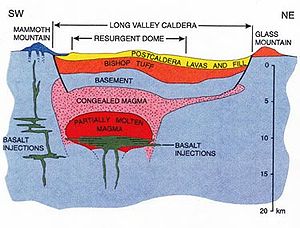
" that was formed by magma
tic uplift. The area is still volcanically active, the caldera itself is extinct, seismic mapping has shown the magma body deep underground is mostly crystallized and not molten anymore. There is a hydrothermal power plant near the resurgent dome. The Bishop tuff is the oldest normally magnetized tuff (that is, it was formed when the Earth's magnetic north was near the north pole – as it is today). In the geologic past, water gathered in the Long Valley caldera and overtopped its rim forming the Owens River
Gorge.
Notable geothermal areas in Long Valley include Casa Diablo at the base of resurgent dome; and Hot Creek which is about 5 miles (8 km) from Casa Diablo and cuts into part of resurgent dome. Hydrothermal activity has altered many rocks in the caldera transforming them into travertine
and clay
. The Huntley clay mine is exposed on resurgent dome and appears as a brilliant white band. A white chalky clay called kaolinite
is mined here.
Mammoth Mountain
(11050 ft (3,368 m)), is a composite volcano made up of about 12 rhyodacite
and quartz latite
domes extruded along the southwest rim of Long Valley Caldera from 200,000 to 50,000 years ago. Mammoth Mountain is one of the eruptive centers that developed late in the evolutionary cycle of the Long Valley Caldera complex.
The history and deposits of the Mono and Inyo Craters overlap with Long Valley Caldera in time and space. The Mono-Inyo Craters volcanic field developed along a 30-mile-long (50 km) fissure system that extends northward from Mammoth Mountain on the southwestern rim of the caldera to Mono Lake
.
Hot Creek
has cut into the floor of the caldera and passes through hot springs. The warm water of Hot Creek supports many trout, and is used at the Hot Creek Fish Hatchery
. Hot Creek is part of a stream that follows part of a fault line and is well known for its hydrothermal pools and for the contrast swimmers experience between the cold stream water and either the occasional plume of very hot water (which can scald swimmers' feet and can on rare occasions cause more serious injury) or even long and very strong upwellings of hot water when enough water is in the hydrothermal system. The creek was closed to swimming in 2006 after geothermal activity in the area increased, and was still closed as of August 2010. There are a number of other hot springs in the area, some of which are open to bathers.
as is Yellowstone or Hawaii
, nor is it the result of subduction
such as that which produces the volcanism of the Cascades.
The known volcanic
history of the Long Valley Caldera area started several million years ago when magma
began to collect several miles below the surface. Volcanic activity became concentrated in the vicinity of the present site of Long Valley Caldera 3.1 to 2.5 million years ago with eruptions of rhyodacite
followed by high-silica rhyolite from 2.1 to 0.8 million years ago. After some time a cluster of mostly rhyolitic
volcanoes formed in the area. All told, about 1,500 square miles (4,000 square kilometers) were covered by lava.
All but one of these volcanoes, 1–2 million year old Glass Mountain
(made of obsidian
), was destroyed by the major eruption of the area 760,000 years ago, which released 600 cubic kilometers of material from vents just inside the margin of the caldera (the 1980 Mount St. Helens eruption was 1.2 km³). About half of this material was ejected in a series of pyroclastic flow
s of a very hot (1,500 degree Fahrenheit or 800 degree Celsius) mixture of noxious gas
, pumice
, and ash
that covered the surrounding area hundreds of feet deep. One lobe of this material moved south into Owens Valley
, past where Big Pine, California
now lies. Another lobe moved west over the crest of the Sierra Nevada and into the drainage of the San Joaquin River
. The rest of the pyroclastic material along with 300 km³ of other matter, was blown as far as 25 miles (40 km) into the air where wind
s distributed it as far away as eastern Nebraska
and Kansas
. However, much of the material ejected straight into the air fell back to earth to fill the 2 to 3 km deep caldera two-thirds to its rim.
The Long Valley volcano is unusual in that it has produced eruptions of both basaltic and silicic lava in the same geological place.
Water from the Owens River
filled the caldera to a depth of 300 metres (984.3 ft) as of 600,000 years ago. At that time, the lake surface was at an elevation near 7500 feet (2,286 m). The lake drained sometime in the last 100,000 years after it overtopped the southern rim of the caldera, eroded the sill, and created the Owens River Gorge
. A human-made dam in the gorge has created Lake Crowley, a partial restoration of the original lake. Since the great eruption, many hot spring
s developed in the area and the resurgent dome has uplifted.
During the last ice age, glaciers filled the canyons leading to Long Valley, but the valley floor was clear of ice. Excellent examples of terminal moraine
s can be seen at Long Valley: these moraines are the debris left from glacial sculpting. Laurel Creek, Convict Creek, and McGee Creek all have prominent moraines.
 In May 1980, a strong earthquake
swarm that included four Richter magnitude 6 earthquakes struck the southern margin of Long Valley Caldera associated with a 10 inch (25-cm), dome-shaped uplift of the caldera floor. These events marked the onset of the latest period of caldera unrest that continues to this day. This ongoing unrest includes recurring earthquake swarms and continued dome-shaped uplift of the central section of the caldera (the resurgent dome) accompanied by changes in thermal springs and gas emissions. After the quake another road was created as an escape route. Its name at first was proposed as the "Mammoth Escape Route" but was changed to the Mammoth Scenic Loop after Mammoth area businesses and land owners complained.
In 1982, the United States Geological Survey
under the Volcano Hazards Program
began an intensive effort to monitor and study geologic unrest in Long Valley Caldera. The goal of this effort is to provide residents and civil authorities in the area reliable information on the nature of the potential hazards posed by this unrest and timely warning of an impending volcanic eruption, should it develop. Most, perhaps all, volcanic eruptions are preceded and accompanied by geophysical and geochemical changes in the volcanic system. Common precursory indicators of volcanic activity include increased seismicity, ground deformation, and variations in the nature and rate of gas emissions.
s, fumarole
s (steam
vents), and mineral
deposits. Hot springs exist primarily in the eastern half of the caldera
where land-surface elevations are relatively low; fumaroles exist primarily in the western half where elevations are higher. Mineral deposits from thermal activity are found on an uplifted area called the resurgent dome
, at Little Hot Creek springs, Hot Creek Gorge, and other locations in the south and east moat
s of the caldera.
Hot springs discharge primarily in Hot Creek Gorge, along Little Hot Creek, and in the Alkali Lakes area. The largest springs are in Hot Creek Gorge where about 250 liters per second of thermal water discharge and account for about 80% of the total thermal water discharge in the caldera. At the other extreme are springs at Hot Creek Fish Hatchery which contain a small component (2–5%) of thermal water that raises water temperatures about 5 °C higher than background temperatures. Use of the warm spring water in the hatchery
has increased fish production because trout
growth rates are faster in the warm water than in ambient stream temperatures in Long Valley.
In hydrothermal systems the circulation of groundwater
is driven by a combination of topography
and heat
sources. In Long Valley Caldera, the system is recharged primarily from snow
-melt in the highlands around the western and southern rims of the caldera. The meteoric water infiltrates to depths of a few kilometers where it is heated to at least 220 °C by hot rock near geologically young intrusions. Upflow occurs in the west moat where the heated water with lower density rises along steeply inclined fractures to depths of 1–2 km. This hydrothermal fluid flows laterally, down the hydraulic gradient, from the west to the southeast around the resurgent dome and then eastward to discharge points along Hot Creek and around Crowley Lake
. Reservoir temperatures in the volcanic fill decline from 220 °C near the Inyo Craters to 50 °C near Crowley Lake due to a combination of heat loss and mixing with cold water.
Hot Creek has been a popular local swimming hole for decades. Over a dozen people have died in Hot Creek since the late 1960s but most of these deaths happened to individuals who ignored the numerous warning signs and attempted to use the hydrothermal pools as hot tub
s (like the stream portion of the creek, these pools alternate in temperature but the eruptions in the pools are of super-heated water in already very hot water). Recent geothermal instability has led to its temporary closure for swimming. Officials are unsure of when (if ever) Hot Creek will officially reopen for swimming.
: the area offers skiing
and snowboarding
in the winter, and mountain biking
in the summer. The Hot Creek
tourist attraction was closed to swimming in 2006 due to increased geothermal activity.
Hiking
and off-road vehicle
driving is available throughout the caldera, and in the glacial valleys of the Sherwin Range
, immediately to the south of the caldera. Hikers can hike to several lakes in these glacial valleys, including Valentine Lake, Convict Lake
, Lake Dorothy, and Laurel Lakes. Crowley Lake
, at the south end of the caldera, is noted for its fishing.
The nearest hotel accommodations to the caldera are in Mammoth Lakes, California
. There are also campgrounds scattered throughout the caldera, and in the mountains near the edge of the caldera.
Eastern California
Eastern California is a term that refers to the eastern region of California, United States. It can refer to either the strip to the east of the crest of the Sierra Nevada, or to the easternmost counties of California.-Culture and history:...
that is adjacent to Mammoth Mountain
Mammoth Mountain
Mammoth Mountain is a lava dome complex west of the town of Mammoth Lakes, California in the Inyo National Forest of Madera County and Mono County. It is home to a large ski area on the Mono County side....
. The valley is one of the largest caldera
Caldera
A caldera is a cauldron-like volcanic feature usually formed by the collapse of land following a volcanic eruption, such as the one at Yellowstone National Park in the US. They are sometimes confused with volcanic craters...
s on earth
Earth
Earth is the third planet from the Sun, and the densest and fifth-largest of the eight planets in the Solar System. It is also the largest of the Solar System's four terrestrial planets...
, measuring about 20 miles (32.2 km) long (east-west) and 11 miles (17.7 km) wide (north-south). The elevation of the floor of the caldera is 6500 feet (1,981.2 m) in the east and 8500 feet (2,590.8 m) in the west. The elevation of the caldera walls reach 9800 –, except in the east where the wall rises only 500 feet (152.4 m) to an elevation of 7550 feet (2,301.2 m).
Long Valley was formed 760,000 years ago when a huge volcanic
Supervolcano
A supervolcano is a volcano capable of producing a volcanic eruption with an ejecta volume greater than 1,000 cubic kilometers . This is thousands of times larger than most historic volcanic eruptions. Supervolcanoes can occur when magma in the Earth rises into the crust from a hotspot but is...
eruption released very hot ash that later cooled to form the Bishop tuff
Bishop Tuff
The Bishop Tuff is a welded tuff that formed 767100 ± 900 years ago as a rhyolitic pyroclastic flow during the eruption that created the Long Valley Caldera. Large outcrops of the tuff are located in Inyo and Mono Counties, California, United States....
that is common to the area. The eruption was so colossal that the magma chamber
Magma chamber
A magma chamber is a large underground pool of molten rock found beneath the surface of the Earth. The molten rock in such a chamber is under great pressure, and given enough time, that pressure can gradually fracture the rock around it creating outlets for the magma...
under the now destroyed volcano was significantly emptied to the point of collapse. The collapse itself caused an even larger secondary eruption of pyroclastic ash that burned and buried thousands of square miles. Ash from this eruption blanketed much of the western part of what is now the United States
United States
The United States of America is a federal constitutional republic comprising fifty states and a federal district...
. Geologists call topographic depressions formed in this manner caldera
Caldera
A caldera is a cauldron-like volcanic feature usually formed by the collapse of land following a volcanic eruption, such as the one at Yellowstone National Park in the US. They are sometimes confused with volcanic craters...
s.
Geography
Near the center of the caldera there is a mound called the "resurgent domeResurgent dome
In geology, a resurgent dome is a dome formed by swelling or rising of a caldera floor due to movement in the magma chamber beneath it. Unlike a lava dome, a resurgent dome is not formed by the extrusion of highly viscous lava onto the surface, but rather by the uplift and deformation of the...
" that was formed by magma
Magma
Magma is a mixture of molten rock, volatiles and solids that is found beneath the surface of the Earth, and is expected to exist on other terrestrial planets. Besides molten rock, magma may also contain suspended crystals and dissolved gas and sometimes also gas bubbles. Magma often collects in...
tic uplift. The area is still volcanically active, the caldera itself is extinct, seismic mapping has shown the magma body deep underground is mostly crystallized and not molten anymore. There is a hydrothermal power plant near the resurgent dome. The Bishop tuff is the oldest normally magnetized tuff (that is, it was formed when the Earth's magnetic north was near the north pole – as it is today). In the geologic past, water gathered in the Long Valley caldera and overtopped its rim forming the Owens River
Owens River
The Owens River is a river in southeastern California in the United States, approximately long. It drains into and through the Owens Valley, an arid basin between the eastern slope of the Sierra Nevada and the western faces of the Inyo and White Mountains. The river terminates at Owens Lake, but...
Gorge.
Notable geothermal areas in Long Valley include Casa Diablo at the base of resurgent dome; and Hot Creek which is about 5 miles (8 km) from Casa Diablo and cuts into part of resurgent dome. Hydrothermal activity has altered many rocks in the caldera transforming them into travertine
Travertine
Travertine is a form of limestone deposited by mineral springs, especially hot springs. Travertine often has a fibrous or concentric appearance and exists in white, tan, and cream-colored varieties. It is formed by a process of rapid precipitation of calcium carbonate, often at the mouth of a hot...
and clay
Clay
Clay is a general term including many combinations of one or more clay minerals with traces of metal oxides and organic matter. Geologic clay deposits are mostly composed of phyllosilicate minerals containing variable amounts of water trapped in the mineral structure.- Formation :Clay minerals...
. The Huntley clay mine is exposed on resurgent dome and appears as a brilliant white band. A white chalky clay called kaolinite
Kaolinite
Kaolinite is a clay mineral, part of the group of industrial minerals, with the chemical composition Al2Si2O54. It is a layered silicate mineral, with one tetrahedral sheet linked through oxygen atoms to one octahedral sheet of alumina octahedra...
is mined here.
Mammoth Mountain
Mammoth Mountain
Mammoth Mountain is a lava dome complex west of the town of Mammoth Lakes, California in the Inyo National Forest of Madera County and Mono County. It is home to a large ski area on the Mono County side....
(11050 ft (3,368 m)), is a composite volcano made up of about 12 rhyodacite
Rhyodacite
Rhyodacite is an extrusive volcanic rock intermediate in composition between dacite and rhyolite. It is the extrusive equivalent of granodiorite. Phenocrysts of sodium rich plagioclase, sanidine, quartz, and biotite or hornblende are typically set in an aphanitic to glassy light to intermediate...
and quartz latite
Quartz latite
A quartz latite is a volcanic rock or fine grained intrusive rock equivalent to a latite with a phenocryst modal composition containing 5-20% quartz. Above 20% quartz, the rock would be classified as a rhyolite. It is the fine grained equivalent of a quartz monzonite containing approximately equal...
domes extruded along the southwest rim of Long Valley Caldera from 200,000 to 50,000 years ago. Mammoth Mountain is one of the eruptive centers that developed late in the evolutionary cycle of the Long Valley Caldera complex.
The history and deposits of the Mono and Inyo Craters overlap with Long Valley Caldera in time and space. The Mono-Inyo Craters volcanic field developed along a 30-mile-long (50 km) fissure system that extends northward from Mammoth Mountain on the southwestern rim of the caldera to Mono Lake
Mono Lake
Mono Lake is a large, shallow saline lake in Mono County, California, formed at least 760,000 years ago as a terminal lake in a basin that has no outlet to the ocean...
.
Hot Creek
Hot Creek (Mono County, California)
Hot Creek, starting as Mammoth Creek, is a stream in Mono County of eastern California, in the Western United States. It is within the Inyo National Forest.-Mammoth Creek:...
has cut into the floor of the caldera and passes through hot springs. The warm water of Hot Creek supports many trout, and is used at the Hot Creek Fish Hatchery
Hot Creek (Mono County, California)
Hot Creek, starting as Mammoth Creek, is a stream in Mono County of eastern California, in the Western United States. It is within the Inyo National Forest.-Mammoth Creek:...
. Hot Creek is part of a stream that follows part of a fault line and is well known for its hydrothermal pools and for the contrast swimmers experience between the cold stream water and either the occasional plume of very hot water (which can scald swimmers' feet and can on rare occasions cause more serious injury) or even long and very strong upwellings of hot water when enough water is in the hydrothermal system. The creek was closed to swimming in 2006 after geothermal activity in the area increased, and was still closed as of August 2010. There are a number of other hot springs in the area, some of which are open to bathers.
Geology
Caldera
The tectonic causes of the Long Valley volcanism are still largely unexplained and are therefore a matter of much ongoing research. Long Valley is not above a hotspotHotspot (geology)
The places known as hotspots or hot spots in geology are volcanic regions thought to be fed by underlying mantle that is anomalously hot compared with the mantle elsewhere. They may be on, near to, or far from tectonic plate boundaries. There are two hypotheses to explain them...
as is Yellowstone or Hawaii
Hawaii
Hawaii is the newest of the 50 U.S. states , and is the only U.S. state made up entirely of islands. It is the northernmost island group in Polynesia, occupying most of an archipelago in the central Pacific Ocean, southwest of the continental United States, southeast of Japan, and northeast of...
, nor is it the result of subduction
Subduction
In geology, subduction is the process that takes place at convergent boundaries by which one tectonic plate moves under another tectonic plate, sinking into the Earth's mantle, as the plates converge. These 3D regions of mantle downwellings are known as "Subduction Zones"...
such as that which produces the volcanism of the Cascades.
The known volcanic
Volcano
2. Bedrock3. Conduit 4. Base5. Sill6. Dike7. Layers of ash emitted by the volcano8. Flank| 9. Layers of lava emitted by the volcano10. Throat11. Parasitic cone12. Lava flow13. Vent14. Crater15...
history of the Long Valley Caldera area started several million years ago when magma
Magma
Magma is a mixture of molten rock, volatiles and solids that is found beneath the surface of the Earth, and is expected to exist on other terrestrial planets. Besides molten rock, magma may also contain suspended crystals and dissolved gas and sometimes also gas bubbles. Magma often collects in...
began to collect several miles below the surface. Volcanic activity became concentrated in the vicinity of the present site of Long Valley Caldera 3.1 to 2.5 million years ago with eruptions of rhyodacite
Rhyodacite
Rhyodacite is an extrusive volcanic rock intermediate in composition between dacite and rhyolite. It is the extrusive equivalent of granodiorite. Phenocrysts of sodium rich plagioclase, sanidine, quartz, and biotite or hornblende are typically set in an aphanitic to glassy light to intermediate...
followed by high-silica rhyolite from 2.1 to 0.8 million years ago. After some time a cluster of mostly rhyolitic
Rhyolite
This page is about a volcanic rock. For the ghost town see Rhyolite, Nevada, and for the satellite system, see Rhyolite/Aquacade.Rhyolite is an igneous, volcanic rock, of felsic composition . It may have any texture from glassy to aphanitic to porphyritic...
volcanoes formed in the area. All told, about 1,500 square miles (4,000 square kilometers) were covered by lava.
All but one of these volcanoes, 1–2 million year old Glass Mountain
Glass Mountain (California)
Glass Mountain, on the Inyo National Forest, is one of the tallest peaks in Mono County, California. It consists of a sequence of lava domes, flows, and welded pyroclastic flows of rhyolite composition that were erupted between 2.1 and 0.8 million years ago....
(made of obsidian
Obsidian
Obsidian is a naturally occurring volcanic glass formed as an extrusive igneous rock.It is produced when felsic lava extruded from a volcano cools rapidly with minimum crystal growth...
), was destroyed by the major eruption of the area 760,000 years ago, which released 600 cubic kilometers of material from vents just inside the margin of the caldera (the 1980 Mount St. Helens eruption was 1.2 km³). About half of this material was ejected in a series of pyroclastic flow
Pyroclastic flow
A pyroclastic flow is a fast-moving current of superheated gas and rock , which reaches speeds moving away from a volcano of up to 700 km/h . The flows normally hug the ground and travel downhill, or spread laterally under gravity...
s of a very hot (1,500 degree Fahrenheit or 800 degree Celsius) mixture of noxious gas
Gas
Gas is one of the three classical states of matter . Near absolute zero, a substance exists as a solid. As heat is added to this substance it melts into a liquid at its melting point , boils into a gas at its boiling point, and if heated high enough would enter a plasma state in which the electrons...
, pumice
Pumice
Pumice is a textural term for a volcanic rock that is a solidified frothy lava typically created when super-heated, highly pressurized rock is violently ejected from a volcano. It can be formed when lava and water are mixed. This unusual formation is due to the simultaneous actions of rapid...
, and ash
Volcanic ash
Volcanic ash consists of small tephra, which are bits of pulverized rock and glass created by volcanic eruptions, less than in diameter. There are three mechanisms of volcanic ash formation: gas release under decompression causing magmatic eruptions; thermal contraction from chilling on contact...
that covered the surrounding area hundreds of feet deep. One lobe of this material moved south into Owens Valley
Owens Valley
Owens Valley is the arid valley of the Owens River in eastern California in the United States, to the east of the Sierra Nevada and west of the White Mountains and Inyo Mountains on the west edge of the Great Basin section...
, past where Big Pine, California
Big Pine, California
Big Pine is a census-designated place in Inyo County, California, United States. Big Pine is located south-southeast of Bishop, at an elevation of 3990 feet . The population was 1,756 at the 2010 census, up from 1,350 at the 2000 census...
now lies. Another lobe moved west over the crest of the Sierra Nevada and into the drainage of the San Joaquin River
San Joaquin River
The San Joaquin River is the largest river of Central California in the United States. At over long, the river starts in the high Sierra Nevada, and flows through a rich agricultural region known as the San Joaquin Valley before reaching Suisun Bay, San Francisco Bay, and the Pacific Ocean...
. The rest of the pyroclastic material along with 300 km³ of other matter, was blown as far as 25 miles (40 km) into the air where wind
Wind
Wind is the flow of gases on a large scale. On Earth, wind consists of the bulk movement of air. In outer space, solar wind is the movement of gases or charged particles from the sun through space, while planetary wind is the outgassing of light chemical elements from a planet's atmosphere into space...
s distributed it as far away as eastern Nebraska
Nebraska
Nebraska is a state on the Great Plains of the Midwestern United States. The state's capital is Lincoln and its largest city is Omaha, on the Missouri River....
and Kansas
Kansas
Kansas is a US state located in the Midwestern United States. It is named after the Kansas River which flows through it, which in turn was named after the Kansa Native American tribe, which inhabited the area. The tribe's name is often said to mean "people of the wind" or "people of the south...
. However, much of the material ejected straight into the air fell back to earth to fill the 2 to 3 km deep caldera two-thirds to its rim.
Eruptions
Subsequent eruptions from the Long Valley magma chamber were confined within the caldera with extrusions of relatively hot (crystal-free) rhyolite 700,000 to 600,000 years ago as the caldera floor was upwarped to form the resurgent dome followed by extrusions of cooler, crystal-rich moat rhyolite at 200,000-year intervals (500,000, 300,000, and 100,000 years ago) in clockwise succession around the resurgent dome. The declining volcanic activity and increasingly crystalline lava extruded over the last 650,000 years, as well as other trends, suggest that the magma reservoir under the caldera has now largely crystallized and is unlikely to produce large-scale eruptions in the future.The Long Valley volcano is unusual in that it has produced eruptions of both basaltic and silicic lava in the same geological place.
Water from the Owens River
Owens River
The Owens River is a river in southeastern California in the United States, approximately long. It drains into and through the Owens Valley, an arid basin between the eastern slope of the Sierra Nevada and the western faces of the Inyo and White Mountains. The river terminates at Owens Lake, but...
filled the caldera to a depth of 300 metres (984.3 ft) as of 600,000 years ago. At that time, the lake surface was at an elevation near 7500 feet (2,286 m). The lake drained sometime in the last 100,000 years after it overtopped the southern rim of the caldera, eroded the sill, and created the Owens River Gorge
Owens River Gorge
The Owens River Gorge is a steep 10 mi canyon on the upper Owens River in eastern California in the United States. The canyon is located at the eastern edge of the Sierra Nevada mountains in southern Mono County, along the stretch of the river where it exits the Long Valley near its source...
. A human-made dam in the gorge has created Lake Crowley, a partial restoration of the original lake. Since the great eruption, many hot spring
Hot spring
A hot spring is a spring that is produced by the emergence of geothermally heated groundwater from the Earth's crust. There are geothermal hot springs in many locations all over the crust of the earth.-Definitions:...
s developed in the area and the resurgent dome has uplifted.
During the last ice age, glaciers filled the canyons leading to Long Valley, but the valley floor was clear of ice. Excellent examples of terminal moraine
Terminal moraine
A terminal moraine, also called end moraine, is a moraine that forms at the end of the glacier called the snout.Terminal moraines mark the maximum advance of the glacier. An end moraine is at the present boundary of the glacier....
s can be seen at Long Valley: these moraines are the debris left from glacial sculpting. Laurel Creek, Convict Creek, and McGee Creek all have prominent moraines.
Recent activity
Earthquake
An earthquake is the result of a sudden release of energy in the Earth's crust that creates seismic waves. The seismicity, seismism or seismic activity of an area refers to the frequency, type and size of earthquakes experienced over a period of time...
swarm that included four Richter magnitude 6 earthquakes struck the southern margin of Long Valley Caldera associated with a 10 inch (25-cm), dome-shaped uplift of the caldera floor. These events marked the onset of the latest period of caldera unrest that continues to this day. This ongoing unrest includes recurring earthquake swarms and continued dome-shaped uplift of the central section of the caldera (the resurgent dome) accompanied by changes in thermal springs and gas emissions. After the quake another road was created as an escape route. Its name at first was proposed as the "Mammoth Escape Route" but was changed to the Mammoth Scenic Loop after Mammoth area businesses and land owners complained.
In 1982, the United States Geological Survey
United States Geological Survey
The United States Geological Survey is a scientific agency of the United States government. The scientists of the USGS study the landscape of the United States, its natural resources, and the natural hazards that threaten it. The organization has four major science disciplines, concerning biology,...
under the Volcano Hazards Program
Volcano Hazards Program
The Volcano Hazards Program is a program directed by the USGS that monitors the activity of volcanoes and the public awareness of eruptions....
began an intensive effort to monitor and study geologic unrest in Long Valley Caldera. The goal of this effort is to provide residents and civil authorities in the area reliable information on the nature of the potential hazards posed by this unrest and timely warning of an impending volcanic eruption, should it develop. Most, perhaps all, volcanic eruptions are preceded and accompanied by geophysical and geochemical changes in the volcanic system. Common precursory indicators of volcanic activity include increased seismicity, ground deformation, and variations in the nature and rate of gas emissions.
Hydrothermal system
The Long Valley Caldera hosts an active hydrothermal system that includes hot springHot spring
A hot spring is a spring that is produced by the emergence of geothermally heated groundwater from the Earth's crust. There are geothermal hot springs in many locations all over the crust of the earth.-Definitions:...
s, fumarole
Fumarole
A fumarole is an opening in a planet's crust, often in the neighborhood of volcanoes, which emits steam and gases such as carbon dioxide, sulfur dioxide, hydrochloric acid, and hydrogen sulfide. The steam is created when superheated water turns to steam as its pressure drops when it emerges from...
s (steam
Steam
Steam is the technical term for water vapor, the gaseous phase of water, which is formed when water boils. In common language it is often used to refer to the visible mist of water droplets formed as this water vapor condenses in the presence of cooler air...
vents), and mineral
Mineral
A mineral is a naturally occurring solid chemical substance formed through biogeochemical processes, having characteristic chemical composition, highly ordered atomic structure, and specific physical properties. By comparison, a rock is an aggregate of minerals and/or mineraloids and does not...
deposits. Hot springs exist primarily in the eastern half of the caldera
Caldera
A caldera is a cauldron-like volcanic feature usually formed by the collapse of land following a volcanic eruption, such as the one at Yellowstone National Park in the US. They are sometimes confused with volcanic craters...
where land-surface elevations are relatively low; fumaroles exist primarily in the western half where elevations are higher. Mineral deposits from thermal activity are found on an uplifted area called the resurgent dome
Resurgent dome
In geology, a resurgent dome is a dome formed by swelling or rising of a caldera floor due to movement in the magma chamber beneath it. Unlike a lava dome, a resurgent dome is not formed by the extrusion of highly viscous lava onto the surface, but rather by the uplift and deformation of the...
, at Little Hot Creek springs, Hot Creek Gorge, and other locations in the south and east moat
Moat
A moat is a deep, broad ditch, either dry or filled with water, that surrounds a castle, other building or town, historically to provide it with a preliminary line of defence. In some places moats evolved into more extensive water defences, including natural or artificial lakes, dams and sluices...
s of the caldera.
Hot springs discharge primarily in Hot Creek Gorge, along Little Hot Creek, and in the Alkali Lakes area. The largest springs are in Hot Creek Gorge where about 250 liters per second of thermal water discharge and account for about 80% of the total thermal water discharge in the caldera. At the other extreme are springs at Hot Creek Fish Hatchery which contain a small component (2–5%) of thermal water that raises water temperatures about 5 °C higher than background temperatures. Use of the warm spring water in the hatchery
Hatchery
A hatchery is a facility where eggs are hatched under artificial conditions, especially those of fish or poultry. It may be used for ex-situ conservation purposes, i.e. to breed rare or endangered species under controlled conditions; alternatively, it may be for economic reasons A hatchery is a...
has increased fish production because trout
Trout
Trout is the name for a number of species of freshwater and saltwater fish belonging to the Salmoninae subfamily of the family Salmonidae. Salmon belong to the same family as trout. Most salmon species spend almost all their lives in salt water...
growth rates are faster in the warm water than in ambient stream temperatures in Long Valley.
In hydrothermal systems the circulation of groundwater
Groundwater
Groundwater is water located beneath the ground surface in soil pore spaces and in the fractures of rock formations. A unit of rock or an unconsolidated deposit is called an aquifer when it can yield a usable quantity of water. The depth at which soil pore spaces or fractures and voids in rock...
is driven by a combination of topography
Topography
Topography is the study of Earth's surface shape and features or those ofplanets, moons, and asteroids...
and heat
Heat
In physics and thermodynamics, heat is energy transferred from one body, region, or thermodynamic system to another due to thermal contact or thermal radiation when the systems are at different temperatures. It is often described as one of the fundamental processes of energy transfer between...
sources. In Long Valley Caldera, the system is recharged primarily from snow
Snow
Snow is a form of precipitation within the Earth's atmosphere in the form of crystalline water ice, consisting of a multitude of snowflakes that fall from clouds. Since snow is composed of small ice particles, it is a granular material. It has an open and therefore soft structure, unless packed by...
-melt in the highlands around the western and southern rims of the caldera. The meteoric water infiltrates to depths of a few kilometers where it is heated to at least 220 °C by hot rock near geologically young intrusions. Upflow occurs in the west moat where the heated water with lower density rises along steeply inclined fractures to depths of 1–2 km. This hydrothermal fluid flows laterally, down the hydraulic gradient, from the west to the southeast around the resurgent dome and then eastward to discharge points along Hot Creek and around Crowley Lake
Crowley Lake
Crowley Lake is a reservoir on the upper Owens River in southern Mono County, California in the United States. It was created in 1941 by the Los Angeles Department of Water and Power as storage for the Los Angeles Aqueduct and for flood control...
. Reservoir temperatures in the volcanic fill decline from 220 °C near the Inyo Craters to 50 °C near Crowley Lake due to a combination of heat loss and mixing with cold water.
Hot Creek has been a popular local swimming hole for decades. Over a dozen people have died in Hot Creek since the late 1960s but most of these deaths happened to individuals who ignored the numerous warning signs and attempted to use the hydrothermal pools as hot tub
Hot tub
A hot tub is a large tub or small pool full of heated water and used for soaking, relaxation, massage, or hydrotherapy. In most cases, they have jets for massage purposes. Hot tubs are usually located outdoors, and are often sheltered for protection from the elements, as well as for privacy....
s (like the stream portion of the creek, these pools alternate in temperature but the eruptions in the pools are of super-heated water in already very hot water). Recent geothermal instability has led to its temporary closure for swimming. Officials are unsure of when (if ever) Hot Creek will officially reopen for swimming.
Tourism and hiking
The largest tourist attraction in the caldera is the Mammoth Mountain Ski AreaMammoth Mountain Ski Area
Mammoth Mountain Ski Area is a large ski resort located in Eastern California, along the east side of the Sierra Nevada mountain range in the Inyo National Forest.- Description :...
: the area offers skiing
Skiing
Skiing is a recreational activity using skis as equipment for traveling over snow. Skis are used in conjunction with boots that connect to the ski with use of a binding....
and snowboarding
Snowboarding
Snowboarding is a sport that involves descending a slope that is covered with snow on a snowboard attached to a rider's feet using a special boot set onto mounted binding. The development of snowboarding was inspired by skateboarding, sledding, surfing and skiing. It was developed in the U.S.A...
in the winter, and mountain biking
Mountain biking
Mountain biking is a sport which consists of riding bicycles off-road, often over rough terrain, using specially adapted mountain bikes. Mountain bikes share similarities with other bikes, but incorporate features designed to enhance durability and performance in rough terrain.Mountain biking can...
in the summer. The Hot Creek
Hot Creek (Mono County, California)
Hot Creek, starting as Mammoth Creek, is a stream in Mono County of eastern California, in the Western United States. It is within the Inyo National Forest.-Mammoth Creek:...
tourist attraction was closed to swimming in 2006 due to increased geothermal activity.
Hiking
Hiking
Hiking is an outdoor activity which consists of walking in natural environments, often in mountainous or other scenic terrain. People often hike on hiking trails. It is such a popular activity that there are numerous hiking organizations worldwide. The health benefits of different types of hiking...
and off-road vehicle
Off-road vehicle
An off-road vehicle is considered to be any type of vehicle which is capable of driving on and off paved or gravel surface. It is generally characterized by having large tires with deep, open treads, a flexible suspension, or even caterpillar tracks...
driving is available throughout the caldera, and in the glacial valleys of the Sherwin Range
Sherwin Range
The Sherwin Range is a mountain range that is a part of the Sierra Nevada, in California, USA. The range is immediately to the south of the Long Valley Caldera, stretching from just south of the town of Mammoth Lakes, California to the Wheeler Crest...
, immediately to the south of the caldera. Hikers can hike to several lakes in these glacial valleys, including Valentine Lake, Convict Lake
Convict Lake
Convict Lake , is a lake in the Sherwin Range of the Sierra Nevada in California, USA. It is known for its fishing and the dramatic mountains that surround the lake....
, Lake Dorothy, and Laurel Lakes. Crowley Lake
Crowley Lake
Crowley Lake is a reservoir on the upper Owens River in southern Mono County, California in the United States. It was created in 1941 by the Los Angeles Department of Water and Power as storage for the Los Angeles Aqueduct and for flood control...
, at the south end of the caldera, is noted for its fishing.
The nearest hotel accommodations to the caldera are in Mammoth Lakes, California
Mammoth Lakes, California
-History:The European history of Mammoth Lakes started in 1877, when four prospectors staked a claim on Mineral Hill, south of the current town, along Old Mammoth Road. In 1878, the Mammoth Mining Company was organized to mine Mineral Hill, which caused a gold rush. By the end of 1878, 1500 people...
. There are also campgrounds scattered throughout the caldera, and in the mountains near the edge of the caldera.
See also
- Mono-Inyo CratersMono-Inyo CratersThe Mono–Inyo Craters is a volcanic chain of craters, domes and lava flows in Eastern California that stretches from the northwest shore of Mono Lake to the south of Mammoth Mountain. The chain is located in Mono County in the U.S. state of California...
- Map of Long Valley-Mono area
- Glass MountainGlass Mountain (California)Glass Mountain, on the Inyo National Forest, is one of the tallest peaks in Mono County, California. It consists of a sequence of lava domes, flows, and welded pyroclastic flows of rhyolite composition that were erupted between 2.1 and 0.8 million years ago....