

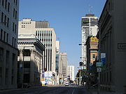
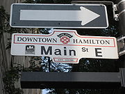
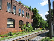
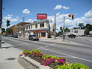
Main Street (Hamilton, Ontario)
Encyclopedia
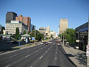
Hamilton, Ontario
Hamilton is a port city in the Canadian province of Ontario. Conceived by George Hamilton when he purchased the Durand farm shortly after the War of 1812, Hamilton has become the centre of a densely populated and industrialized region at the west end of Lake Ontario known as the Golden Horseshoe...
, Canada
Canada
Canada is a North American country consisting of ten provinces and three territories. Located in the northern part of the continent, it extends from the Atlantic Ocean in the east to the Pacific Ocean in the west, and northward into the Arctic Ocean...
. It starts east of Wilson Street in Ancaster
Ancaster, Ontario
Ancaster is a picturesque and historic community located on the Niagara escarpment, within the greater area of the city of Hamilton, Ontario, Canada. This former town was founded officially in 1793 and was one of the oldest European communities established in present day Ontario along with Windsor...
at White Chapel Cemetery as a two-way street and switches over to a one-way street (Eastbound) at Paradise Road South, in Westdale
Westdale, Ontario
Westdale is a residential neighbourhood in Hamilton, Ontario, Canada. It is centred on the Westdale Village shopping district and located near McMaster University. Westdale has been the heart of the Jewish community of Hamilton for many years...
, where it continues up to the Delta where it once again switches over to a two-way street the rest of the way eastward and ends just past Parkdale Avenue
Parkdale Avenue (Hamilton, Ontario)
Parkdale Avenue, is a Lower City arterial road in Hamilton, Ontario, Canada. It starts off just South of Lawrence Road at Hixon Road and is a two-way street throughout, stretching northward through the city's North End industrial neighbourhood and ends just north of the Burlington Street East...
at Roxborough Park.
History
On June 20, 1877, the first commercial telephone service in Canada began in Hamilton, Ontario. Hugh Cossart Baker, Jr.
Hugh Cossart Baker, Jr.
Hugh Cossart Baker, Jr. , Businessman, telephone pioneer.On June 20, 1877, Hugh Cossart Baker, Jr. started up the first commercial telephone service in Canada in the city of Hamilton, Ontario. Then in 1878, he made the first telephone exchange in the British Empire...
learned of Alexander Graham Bell
Alexander Graham Bell
Alexander Graham Bell was an eminent scientist, inventor, engineer and innovator who is credited with inventing the first practical telephone....
's invention in 1877 at the Philadelphia International Exposition and from there decided to test the communication tool in Hamilton. Hugh Cossart Baker Jr. is credited with making the first telephone exchange in the British Empire
British Empire
The British Empire comprised the dominions, colonies, protectorates, mandates and other territories ruled or administered by the United Kingdom. It originated with the overseas colonies and trading posts established by England in the late 16th and early 17th centuries. At its height, it was the...
from an office building (Exchange Building) at the corner of James and Main Street East which still stands there today (March 2007).
In 1925, The first traffic lights in Canada went into operation at the Delta. (11 June, 1925).
McMaster University
McMaster University
McMaster University is a public research university whose main campus is located in Hamilton, Ontario, Canada. The main campus is located on of land in the residential neighbourhood of Westdale, adjacent to Hamilton's Royal Botanical Gardens...
arrived in Hamilton in 1930 from Bloor Street in Toronto. The total student population at McMaster University is well over 27,000. Almost two-thirds of the students come from outside the immediate Hamilton region.
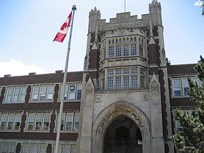
Built in 1931, Westdale Secondary School
Westdale Secondary School
Westdale Secondary School is a public high school founded in 1931 in Hamilton, Ontario. It is the second oldest high school in the city of Hamilton and is located in Westdale Village, a suburb in the west-end of the city. It is administered by the Hamilton-Wentworth District School Board...
was immediately deemed the largest composite school in the British Empire
British Empire
The British Empire comprised the dominions, colonies, protectorates, mandates and other territories ruled or administered by the United Kingdom. It originated with the overseas colonies and trading posts established by England in the late 16th and early 17th centuries. At its height, it was the...
, having cost $1.3 million to build and consisting of 4.7 hectares of building, grounds and athletic fields. A number of famous celebrities from Hamilton are graduates of the school. Alumni members include, WNBA basketball player Shona Thorburn
Shona Thorburn
Shona Thorburn is a Canadian professional basketball player, formerly a point guard for the Seattle Storm of the WNBA....
, SCTV
Second City Television
Second City Television is a Canadian television sketch comedy show offshoot from Toronto's The Second City troupe that ran between 1976 and 1984.- Premise :...
alumni Eugene Levy
Eugene Levy
Eugene Levy, CM is a Canadian actor, comedian, television director, producer, musician, and writer. He is known for his work in Canadian television series, American movies, and television movies. He is the only actor to have appeared in all eight of the American Pie films, as Noah Levenstein...
, & Martin Short
Martin Short
Martin Hayter Short, CM is a Canadian actor, comedian, writer, singer and producer. He is best-known for his comedy work, particularly on the TV programs SCTV and Saturday Night Live...
, Lincoln Alexander
Lincoln Alexander
-External links:* * *...
who served as the 24th Lieutenant-Governor of Ontario
Ontario
Ontario is a province of Canada, located in east-central Canada. It is Canada's most populous province and second largest in total area. It is home to the nation's most populous city, Toronto, and the nation's capital, Ottawa....
from 1985 to 1991, John C. Munro member of Parliament for Hamilton East (1962-1984), Canadian sportscaster Brian Williams
Brian Williams (sportscaster)
Brian Williams is a Canadian sportscaster who is best known for his coverage of the Olympic Games.-Biography:Williams' father was a very successful doctor...
, football players Jim Young
Jim Young
James Norman "Dirty Thirty" Young is a former professional American football and Canadian football player. Young played running back and wide receiver for the NFL's Minnesota Vikings for one season , and the CFL's BC Lions for twelve seasons...
& Russ Jackson
Russ Jackson
Russell Stanley "Russ" Jackson, OC is a former professional Canadian football quarterback. Jackson spent his entire 12-year professional football career with the Ottawa Rough Riders of the Canadian Football League...
, NHL players Harry Howell
Harry Howell (hockey player)
Henry Vernon Howell is a former professional hockey player and longtime star for the New York Rangers of the National Hockey League...
& Steve Staios
Steve Staios
Steven Staios is a Canadian professional ice hockey player who is an alternate captain for the New York Islanders of the National Hockey League. He has played both right wing and defence in the NHL.-Playing career:...
, Gord Lewis member of the band Teenage Head
Teenage Head (band)
Teenage Head is a Canadian rock group from Hamilton, Ontario and was one of the most popular Canadian punk rock bands during the early 1980s....
, CFL
Canadian Football League
The Canadian Football League or CFL is a professional sports league located in Canada. The CFL is the highest level of competition in Canadian football, a form of gridiron football closely related to American football....
powerman David Braley and Daniel Goldberg, Hollywood producer of Twins and Space Jam
Space Jam
Aside from Jordan, a number of NBA players and coaches appeared in the film. Larry Bird portrays a friend of Jordan who joins him for a game of golf. When the Monstars steal the NBA players' talent, they invade a game between the Phoenix Suns and the New York Knicks, causing the Knicks' Patrick...
.
Landmarks

- White Chapel Cemetery
- CNIB building
- Westdale Sign Park
- Cootes Drive Park
- Canadian Martyrs Elementary School
- McMaster UniversityMcMaster UniversityMcMaster University is a public research university whose main campus is located in Hamilton, Ontario, Canada. The main campus is located on of land in the residential neighbourhood of Westdale, adjacent to Hamilton's Royal Botanical Gardens...
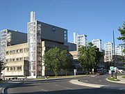
- McMaster Medical Centre
- McMaster Museum of Art
- Ronald V. Joyce StadiumRonald V. Joyce StadiumRon Joyce Stadium is a football stadium owned by McMaster University in Hamilton, Ontario, Canada.The stadium is the home of the McMaster Marauders football team and the Hamilton Nationals of Major League Lacrosse. The stadium features 6,000 permanent seats and temporary seating for an additional...
, (McMaster University) - David Braley Athletic CentreDavid Braley Athletic CentreDavid Braley Athletic Centre, is a new sports venue at McMaster University in Hamilton, Ontario, which opened up in 2007. All McMaster students pay for year-round membership as part of their mandatory student union fees. The facility features an indoor rock climbing wall, Olympic weightlifting...
, (McMaster University) - Dalewood Recreation Centre
- Hamilton Learning Centre
- Columbia International CollegeColumbia International CollegeColumbia International College is the largest private boarding preparatory school in Canada, with an enrollment of more than 1,700 students from over 70 countries in the world. The school is located in Hamilton, Ontario, in the residential neighborhood of Westdale, near McMaster University and...
of Canada - Radio Stations:
- http://www.900chml.com/ AM 900 - CHMLCHML (AM)CHML is a Canadian radio station, broadcasting at 900 AM in Hamilton, Ontario. The station airs a news/talk format branded as AM 900. CHML is owned by Corus Entertainment.- History :...
, newsNewsNews is the communication of selected information on current events which is presented by print, broadcast, Internet, or word of mouth to a third party or mass audience.- Etymology :...
/talkTalk radioTalk radio is a radio format containing discussion about topical issues. Most shows are regularly hosted by a single individual, and often feature interviews with a number of different guests. Talk radio typically includes an element of listener participation, usually by broadcasting live... - http://www.country953.com/ FM 95.3 - CINGCING-FMCING-FM is a Canadian radio station, which broadcasts at 95.3 FM in Hamilton, Ontario. The station airs a classic hits format branded as Vinyl 95.3.CING was launched in 1976 by Burlington Broadcasting, at 107.9 FM in Burlington, Ontario...
, ("Vinyl 95.3"), classic hits - http://www.y108.ca/home/index.cfm FM 107.9 - CJXYCJXY-FMCJXY-FM is a Canadian radio station, broadcasting at 107.9 FM and serving the Hamilton, Ontario market, but licensed to the nearby city of Burlington. The station broadcasts a mainstream rock format as Y108. Its signal can be heard as far north as Toronto and Vaughan and as far south as St....
, ("Y108"), classic rockClassic rockClassic rock is a radio format which developed from the album-oriented rock format in the early 1980s. In the United States, the classic rock format features music ranging generally from the late 1960s to the late 1980s, primarily focusing on the hard rock genre that peaked in popularity in the...
(licensed to BurlingtonBurlington, OntarioBurlington , is a city located in Halton Region at the western end of Lake Ontario. Burlington is part of the Greater Toronto Area, and is also included in the Hamilton Census Metropolitan Area. Physically, Burlington lies between the north shore of Lake Ontario and the Niagara Escarpment...
but marketed toward Hamilton)
- http://www.900chml.com/ AM 900 - CHML
- Westdale Secondary SchoolWestdale Secondary SchoolWestdale Secondary School is a public high school founded in 1931 in Hamilton, Ontario. It is the second oldest high school in the city of Hamilton and is located in Westdale Village, a suburb in the west-end of the city. It is administered by the Hamilton-Wentworth District School Board...
(Hamilton's "Celebrity High") - Highway 403Highway 403 (Ontario)King's Highway 403, also known as Highway 403, is a 400-series highway in the Canadian province of Ontario that travels between Woodstock and Mississauga, branching off from and reuniting with Highway 401 at both ends and travelling south of it through Hamilton and Mississauga. It is concurrent...
Overpass (bridge) - Cathedral Park
- Dundurn Plaza (shopping)
- Locke StreetLocke Street (Hamilton, Ontario)Locke Street, is a Lower City collector road in Hamilton, Ontario, Canada. It starts off at Aberdeen Avenue as a two-way street going through the Locke Street shopping district up to Main Street where it then becomes a one-way street until it crosses King Street and becomes two-way again going...
Shopping district (Antique shops, Art galleries, Cafes & fine dining Restaurants) - Scottish Rite Castle/ Masonic Centre, Originally the home of George Elias TuckettGeorge Elias TuckettGeorge Elias Tuckett was mayor of Hamilton, Ontario in 1896.Tuckett built a fortune during the American Civil War, cornering a chunk of the tobacco market. He also founded the Tuckett Tobacco Company in 1857...
, (1835-1900), Tuckett Tobacco Company owner + Hamilton's 27th Mayor in 1896. (just South of Main Street on Queen Street SouthQueen Street (Hamilton, Ontario)Queen Street, is a Lower City arterial road in Hamilton, Ontario, Canada. It starts off at Beckett Drive, a mountain-access road in the city and is a two-way street up to Herkimer Street and a one-way street the rest of the way north up to the Canadian National Railway Yard where the road turns... - Hess Village
- 55 Hess (Apartments)
- Econo LodgeEcono LodgeEcono Lodge is an economy motel chain based in the United States and Canada. Econo Lodge is the second largest brand in the Choice Hotels system. It is one of the best known brands in its category and aims to provide affordable rooms to budget travelers. Econo Lodge properties contain a minimum of...
(hotel) - Bay 200, residential apartment building (Hamilton's 10th-tallest building, just South of Main Street West)
- Hamilton-Wentworth District School BoardHamilton-Wentworth District School BoardHamilton-Wentworth District School Board is the public school board in the city of Hamilton, Ontario, which was formed January 1, 1997 via the amalgamation of the Hamilton and Wentworth County school boards. HWDSB teaches approximately 50,000 students in its 114 neighbourhood schools...
Building - Hamilton City HallHamilton City HallHamilton City Hall is located in downtown Hamilton, Ontario, Canada. It is an 8-storey building , located at the corner of Main Street West and Bay Street South, across the street from the Ronald V. Joyce Centre for the Performing Arts and the Hamilton Art Gallery. It was officially opened on...
- Irving Zucker Sculpture Court
- Ronald V. Joyce Centre for the Performing Arts at Hamilton Place
- MacNab Street Presbyterian Church
- Hamilton Street RailwayHSRThe abbreviation HSR may stand for:*High school reunion* High-speed rail* Haliburton Scout Reserve, a Scouts Canada camp located near Haliburton, Ontario* Hamilton Street Railway* Hart-Scott-Rodino Antitrust Improvements Act* Health Services Research...
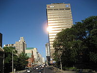
Bus terminal - BDC BuildingBDC BuildingThe BDC Building, 22-storey office tower , is the 5th tallest building in Hamilton, Ontario, Canada. Originally the building was known as the IBM Building when it first opened up in 1972. The "BDC" stands for the Business Development Bank of Canada...
- United Family Court (old Hamilton Public Library building)
- Canadian Football Hall of FameCanadian Football Hall of FameThe Canadian Football Hall of Fame is a not-for-profit corporation, located in Hamilton, Ontario, that celebrates great achievements in Canadian football. It is an open to the public institution. It includes displays about the Canadian Football League, Canadian university football and Canadian...
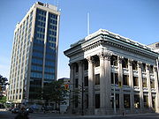
Museum - Bank of Montreal Building (Hamilton) (converted to a National Law firm office)
- Landed Banking and Loan Company building
- Exchange Building (site of the first telephone exchange in the British Empire)
- John SopinkaJohn SopinkaJohn Sopinka, QC was a Canadian lawyer and puisne justice on the Supreme Court of Canada, the first Ukrainian-Canadian appointed to the high court....
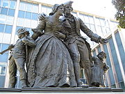
Courthouse - United Empire LoyalistsUnited Empire LoyalistsThe name United Empire Loyalists is an honorific given after the fact to those American Loyalists who resettled in British North America and other British Colonies as an act of fealty to King George III after the British defeat in the American Revolutionary War and prior to the Treaty of Paris...
statue (in front of the Hamilton Courthouse) - The Hamilton Courthouse
- Ramada Plaza (hotel)
- Landmark PlaceLandmark PlaceLandmark Place is the tallest building in downtown Hamilton, Ontario, Canada, at the corner of Main Street East and Catharine Street South in the Corktown/Stinson neighbourhood. This 43-storey building was completed in 1974, and was originally known as the Century 21 building. It was built by Al...
(Hamilton's tallest building) - First Place HamiltonFirst Place Hamilton (building)First Place Hamilton, is a 25-storey, , seniors retirement apartment building in Hamilton, Ontario, Canada, which was built in 1976. It is the 13th-tallest building in Hamilton. This high rise is situated at the corner of King and Wellington Street South which was the original site of the First...
, Seniors apartment building - Indian Buffet Restaurant (formerly Don Cherry's Grapevine)
- St. Patrick Church
- St. Patrick Elementary School
- Cathedral Secondary School
- Grant Avenue Studios, (one block West of Wentworth Street South, 1-block South of Main on 38 Grant Avenue.)
- Columbia Elementary School
- Gage Park
- Hamilton Children's Museum (inside Gage Park)
- Gage Park Bandshell (concert stage)
- Gage Park fountain
- Memorial Elementary School
- Ottawa StreetOttawa Street (Hamilton, Ontario)Ottawa street, is a Lower City arterial road in Hamilton, Ontario, Canada. It starts off at Lawrence Road at the base of the Niagara Escarpment and is a two-way street throughout cutting through the Delta and Crown Point neighbourhoods and the City's North End industrial neighbourhood...
Shopping District - "Textile District" - Delta Secondary SchoolDelta Secondary School (Hamilton)Delta Secondary School was built in 1925 in Hamilton, Ontario, and is the city's oldest high school that is still in operation. It is located on 1284 Main Street East, and is connected to the Delta Honeybears Daycare...
- Montgomery Park
- Burlington Synchronized Swimming Club
- Queenston Traffic Circle (Queenston RoadQueenston Road (Hamilton, Ontario)Queenston Road is a two-way Lower City arterial road in Hamilton, Ontario, Canada. Also known as Highway 8. It starts off at the Queenston Traffic Circle and travels eastward over the Red Hill Valley Parkway and into Stoney Creek past the Fruitland and Winona communities and into Niagara Region as...
branches off from this point) - Sir Winston Churchill Park
- Sir Winston Churchill Secondary SchoolSir Winston Churchill Secondary School (Hamilton)Sir Winston Churchill Secondary School is located at 1715 Main Street East Hamilton Ontario, and is a member of the Hamilton-Wentworth District School Board. Opened in 1967, Sir Winston Churchill Secondary School has a 2009-2010 enrolment of 1100...
- Parkdale Park
- Pat QuinnPat Quinn (ice hockey)John Brian Patrick Quinn , is a former head coach in the National Hockey League , most recently with the Edmonton Oilers. Known by the nickname "The Big Irishman",...
Parkdale Arena - Roxborough Park
Communities
- Ainsley Wood West
- Ainsley Wood North/ Ainsley Wood
- Cootes Paradise A/ Ainsley Wood East
- WestdaleWestdale, OntarioWestdale is a residential neighbourhood in Hamilton, Ontario, Canada. It is centred on the Westdale Village shopping district and located near McMaster University. Westdale has been the heart of the Jewish community of Hamilton for many years...
- StrathconaStrathcona (Hamilton, Ontario)The Strathcona Neighbourhood is located west of downtown Hamilton, Ontario and is bounded by Highway 403, the CNR rail line, Queen Street York Boulevard and Main Street. The neighbourhood is also intersected by several other major street arteries: Dundurn Street , Locke Street, and King Street West...
/ Kirkendall North - Central/ Durand
- Beasley/ Corktown
- Landsdale/ Stinson
- Gibson/ St. Clair
- Stipley/ Blakeley
- Crown Point West/ Delta West
- Crown Point East/ Delta East
- Homeside/ Bartonville
- Normanhurst
- McQuesten West
Parallel roads
- Burlington StreetBurlington StreetBurlington Street is a road in Hamilton, Ontario, stretching along the south shore of Hamilton Harbour in Lake Ontario. Burlington Street has four different statuses along the route. In its western terminus, it is a collector route ending at Bay Street North...
, West/East - Barton StreetBarton Street (Hamilton, Ontario)Barton Street is an arterial road in the Lower City of Hamilton, Ontario, Canada. It's also the longest street in the city. It starts off at the Western end of town at Locke Street North and is a two-way street that stretches eastward through a number of different and varied communities in the...
, West/East - Cannon StreetCannon Street (Hamilton, Ontario)Cannon Street, is a Lower City collector road in Hamilton, Ontario, Canada. It starts off at Queen Street North as a one-way street up to Sherman Avenue North where it then switches over to a two-way street the rest of the way Eastward and ends just past Kenilworth Avenue North on Barons Avenue...
, West/East - Wilson StreetWilson Street (Hamilton, Ontario)Wilson Street is a Lower City collector road in Hamilton, Ontario, Canada. It starts off at James Street North and works its way East and ends at Sherman Avenue North...
- King William StreetKing William Street (Hamilton, Ontario)400px|thumb|Theatre AquariusKing William Street is a Lower City collector road in Hamilton, Ontario, Canada. It starts off at the western-end at James Street North and is a one-way street until Mary Street, where it becomes a two-way street that ends at Wentworth Street North.-History:In 1922,...
- King Street, West/East
- Main Street, West/East; - Queenston RoadQueenston Road (Hamilton, Ontario)Queenston Road is a two-way Lower City arterial road in Hamilton, Ontario, Canada. Also known as Highway 8. It starts off at the Queenston Traffic Circle and travels eastward over the Red Hill Valley Parkway and into Stoney Creek past the Fruitland and Winona communities and into Niagara Region as...
- Jackson StreetJackson Street (Hamilton, Ontario)Jackson Street, is a Lower City collector road in Hamilton, Ontario, Canada. It starts off West of Locke Street South at Jackson Playground as a one-way street up to Queen Street South where it then switches over to a two-way street and is interrupted at Bay Street South the site of the Hamilton...
, West/East - Hunter StreetHunter Street (Hamilton, Ontario)Hunter Street is a Lower City collector road in Hamilton, Ontario, Canada. It is a one-way street that starts West of Locke Street at Hill Street Park and ends two blocks East of Victoria Avenue at Emerald Street...
, West/East - Augusta StreetAugusta Street (Hamilton, Ontario)Augusta Street is a Lower City collector road in Hamilton, Ontario, Canada. A two-way collector road that starts off on James Street South and ends 4-blocks East at Shamrock Park just past Walnut Street South.-History:thumb|Augusta Street, landmark...
- Charlton AvenueCharlton Avenue (Hamilton, Ontario)Charlton Avenue, is a Lower City collector road in Hamilton, Ontario, Canada. This collector road starts of just West of Dundurn Street as a one-way street up to James Street South where it then switches over to a two-way street the rest of the way eastward and ends at Wentworth Street South right...
, West/East - Aberdeen AvenueAberdeen Avenue (Hamilton, Ontario)Aberdeen Avenue is a Lower City arterial road in Hamilton, Ontario, Canada. It starts off just West of Longwood Road South and East of Highway 403 as a two-way thoroughfare up to Queen Street South where it then switches over to a one-way collector road to Bay Street South and then to another...
Niagara Escarpment (Mountain) Roads:
- Concession StreetConcession Street (Hamilton, Ontario)Concession Street is an Upper City arterial road in Hamilton, Ontario, Canada. It starts at Belvidere Avenue, just West of Sam Lawrence Park, and extends eastward past Mountain Drive Park on Upper Gage Avenue and ends shortly thereafter at East 43rd Street.Note: East of East 43rd Street the road...
- Queensdale Avenue West/ East
- Scenic Drive - Fennell AvenueFennell Avenue (Hamilton, Ontario)Fennell Avenue, is an Upper City arterial road in Hamilton, Ontario, Canada. It starts of just West Garth Street on the West mountain and is a two-way street throughout that extends eastward and ends at Mountain Brow Boulevard, a road that wraps around the edge of the Niagara Escarpment on...
, West/East - Sanatorium Road
- Mohawk RoadMohawk Road (Hamilton, Ontario)Mohawk Road, is an Upper City arterial road in Hamilton, Ontario, Canada. It is a two-way street throughout that starts just West of Highway 403 & Meadowlands and travels eastward linking up with the Lincoln M. Alexander Parkway. Mohawk Road east of Highway 403 resumes again in front of Iroquoia...
, West/East - Limeridge RoadLimeridge Road (Hamilton, Ontario)Limeridge Road is a two-way Upper City collector road in Hamilton, Ontario, Canada. It starts off just West of Garth Street/William McCulloch Park as Limeridge Court and cuts across the Hamilton mountain eastward running parallel with the Lincoln M...
West/East - Lincoln M. Alexander ParkwayLincoln M. Alexander ParkwayThe Lincoln Alexander Parkway, officially nicknamed "The Linc", is a municipal expressway in the Canadian city of Hamilton, Ontario. Located on the Hamilton mountain, atop the Niagara Escarpment...
- Mud Street, (Hamilton City Road 11) - Stone Church RoadStone Church Road (Hamilton, Ontario)Stone Church Road, is a two-way Upper City east-west arterial road in Hamilton, Ontario, Canada. It starts at Golf Links Road, just east of Meadowlands, and goes across the Escarpment and ends at Upper Mount Albion Road....
, West/East  ; Rymal Road, West/East
- Twenty Road
Intersecting roads
- Cootes DriveCootes DriveCootes Drive, formerly known as the Dundas Diversion, is a city street in Hamilton, Ontario. The route connects York Boulevard and King Street in Dundas with Highway 2 and Highway 8 to the southeast, and is considered the first divided highway in Canada....
- Longwood Road, South
 Chedoke Parkway, (passes underneath King Street West bridge)
- Dundurn StreetDundurn Street (Hamilton, Ontario)Dundurn Street, is a Lower City arterial road in Hamilton, Ontario, Canada. It is a two-way street that starts off at Mountain Face Park, Niagara Escarpment in front of the Bruce Trail as a collector road, right behind Hillcrest Avenue and then turns into a four lane thoroughfare from Aberdeen...
, South - Locke Street, South
- Queen StreetQueen Street (Hamilton, Ontario)Queen Street, is a Lower City arterial road in Hamilton, Ontario, Canada. It starts off at Beckett Drive, a mountain-access road in the city and is a two-way street up to Herkimer Street and a one-way street the rest of the way north up to the Canadian National Railway Yard where the road turns...
, South - Hess StreetHess Street (Hamilton, Ontario)Hess Street, is a Lower City collector road in Hamilton, Ontario, Canada. It starts off at the base of the Niagara Escarpment right before Aberdeen Avenue, and is a one-way street going north past the Durand and Central neighbourhoods. Between Main and King Street West is where you will find Hess...
, South - Bay StreetBay Street (Hamilton)Bay Street is a Lower City arterial road in Hamilton, Ontario, Canada. It starts at Inglewood Drive, just South of Aberdeen Avenue, as a collector road with only two lanes, then eventually becomes a six lane thoroughfare at its peak. Bay Street also passes through Downtown Hamilton, where many...
, South - MacNab StreetMacNab Street (Hamilton, Ontario)MacNab Street, is a Lower City collector road in Hamilton, Ontario, Canada. It starts in the Durand neighbourhood on Markland Street, as a one-way street going north to Bold Street, where it becomes two-way for one block until Hurst Place where it's cut off by a wall for the Hunter Street railway...
, South - James StreetJames Street (Hamilton, Ontario)James Street is a Lower City arterial road in Hamilton, Ontario, Canada. It starts off at the base of the Niagara Escarpment from James Mountain Road, a mountain-access road in the city, originally was a one-way street going south throughout but now has sections of it that are two-way...
, South - Hughson StreetHughson Street (Hamilton, Ontario)Hughson Street is a Lower City collector road in Hamilton, Ontario, Canada. It starts at Charlton Avenue East at St. Joseph's hospital and runs north to Haymarket Street in the downtown where it's cut off by the Hamilton GO Transit station. Up to this point it is a two-way street...
, South - John StreetJohn Street (Hamilton, Ontario)John Street, is a Lower City arterial road in Hamilton, Ontario, Canada. Originally it was known as Mountain Road or Ancaster Road. It starts off at the base of Arkledun Avenue, a Mountain-access road in the city, just east of St.Joseph's Hospital where it's a one-way street going north and tunnels...
, South - Catharine StreetCatharine Street (Hamilton, Ontario)Catharine Street, is a Lower City collector road in Hamilton, Ontario, Canada. It starts off at Charlton Avenue East at Woolverton Park in the Corktown neighbourhood as a one-way street , tunnels underneath the Hunter Street Railway bridge and stretches up to Barton Street East where it then turns...
, South - Ferguson AvenueFerguson Avenue (Hamilton, Ontario)Ferguson Avenue, is a Lower City collector road in Hamilton, Ontario, Canada. Is a two-way street throughout that starts off at the base of the Mountain on Foster Street. It's interrupted 3-blocks north at Corktown Park where Canadian Pacific Railway lines passes through it...
, South - Wellington StreetWellington Street (Hamilton, Ontario)Wellington Street, is a Lower City arterial road in Hamilton, Ontario, Canada. It starts off at Charlton Avenue East as a two-way street for only one block where it's then blocked off by the Corktown Park and a couple of Canadian National Railway lines that cut through it...
, South - Victoria AvenueVictoria Avenue (Hamilton, Ontario)Victoria Avenue, is a Lower City arterial road in Hamilton, Ontario, Canada. It starts off as a ramp and part of a Mountain-access road, the Claremont Access, on Hunter Street East in the Stinson neighbourhood...
, South - Wentworth StreetWentworth Street (Hamilton, Ontario)Wentworth Street, is a Lower City arterial road in Hamilton, Ontario, Canada. It starts off at the base of the Niagara Escarpment on Charlton Avenue East just before the CP lines as a two-way street for 2-blocks up past Cumberland Avenue up to Rutherford Avenue where it then switches over to a...
, South - Sherman AvenueSherman Avenue (Hamilton, Ontario)Sherman Avenue, is a Lower City collector road in Hamilton, Ontario, Canada. It starts off at the base of the Niagara Escarpment just south of Cumberland Avenue and is a one-way street northbound that cuts through the city's North End industrial neighbourhood and ends at Ship Street, the site of...
, South - Gage AvenueGage Avenue (Hamilton, Ontario)thumb|right|350px|Gage Park WaterfountainGage Avenue, is a Lower City arterial road in Hamilton, Ontario, Canada. It starts off at Lawrence Road at the base of the Niagara Escarpment at the south end of Gage Park...
, South - Ottawa StreetOttawa Street (Hamilton, Ontario)Ottawa street, is a Lower City arterial road in Hamilton, Ontario, Canada. It starts off at Lawrence Road at the base of the Niagara Escarpment and is a two-way street throughout cutting through the Delta and Crown Point neighbourhoods and the City's North End industrial neighbourhood...
, North, South - Kenilworth AvenueKenilworth Avenue (Hamilton, Ontario)Kenilworth Avenue, is a Lower City arterial road in Hamilton, Ontario, Canada. It starts off at the Kenilworth Traffic Circle and Kenilworth Access, a mountain-access road at the base of the Niagara Escarpment and is a two-way street throughout stretching northward through the city's North End...
, North, South - Parkdale AvenueParkdale Avenue (Hamilton, Ontario)Parkdale Avenue, is a Lower City arterial road in Hamilton, Ontario, Canada. It starts off just South of Lawrence Road at Hixon Road and is a two-way street throughout, stretching northward through the city's North End industrial neighbourhood and ends just north of the Burlington Street East...
, North, South