

Ottawa Street (Hamilton, Ontario)
Encyclopedia
Hamilton, Ontario
Hamilton is a port city in the Canadian province of Ontario. Conceived by George Hamilton when he purchased the Durand farm shortly after the War of 1812, Hamilton has become the centre of a densely populated and industrialized region at the west end of Lake Ontario known as the Golden Horseshoe...
, Canada
Canada
Canada is a North American country consisting of ten provinces and three territories. Located in the northern part of the continent, it extends from the Atlantic Ocean in the east to the Pacific Ocean in the west, and northward into the Arctic Ocean...
. It starts off at Lawrence Road at the base of the Niagara Escarpment
Niagara Escarpment
The Niagara Escarpment is a long escarpment, or cuesta, in the United States and Canada that runs westward from New York State, through Ontario, Michigan, Wisconsin and Illinois...
(mountain) and is a two-way street throughout cutting through the Delta and Crown Point neighbourhoods and the City's North End industrial neighbourhood. It ends at Industrial Drive, the site of the Dofasco
Dofasco
Dofasco is a steel company based in Hamilton, Ontario, Canada, which is also home to longtime Canadian rival Stelco. Dofasco is currently a standalone subsidiary of ArcelorMittal, the world's largest steel producer. Previously ordered by the U.S...
steel company.
History
Fabric
A fabric is a textile material, short for "textile fabric".Fabric may also refer to:*Fabric , the spatial and geometric configuration of elements within a rock*Fabric , a nightclub in London, England...
and Textile
Textile
A textile or cloth is a flexible woven material consisting of a network of natural or artificial fibres often referred to as thread or yarn. Yarn is produced by spinning raw fibres of wool, flax, cotton, or other material to produce long strands...
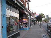
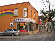
District in Canada and Hamilton's #1 tourist destination. It also hosts an annual Ottawa Street Streetfest, a shopping extravaganza that includes shopping deals, entertainment, foods, crafts; all a part of an outdoor street sale.
In 1862, The city had invested in the Great Western Railway
Great Western Railway (Ontario)
The Great Western Railway was a historic Canadian railway that operated in Canada West and later the province of Ontario, following Confederation...
but the government of Canada favoured the rival Grand Trunk Railway
Grand Trunk Railway
The Grand Trunk Railway was a railway system which operated in the Canadian provinces of Quebec and Ontario, as well as the American states of Connecticut, Maine, Michigan, Massachusetts, New Hampshire, and Vermont. The railway was operated from headquarters in Montreal, Quebec; however, corporate...
. Also, after the end of the Depression
Recession
In economics, a recession is a business cycle contraction, a general slowdown in economic activity. During recessions, many macroeconomic indicators vary in a similar way...
(1857-1862), the population dips downwards in Hamilton and the city could not meet the interest on its bonds, many of which were held by British investors. To save the city from its creditors temporarily, Henry Beasley removes the assessment rolls, thus preventing a levy of special tax. Foundries and machine shops associated with the Great Western Railway failed and several established wholesalers closed their accounts. Daniel C. Gunn's locomotive
Locomotive
A locomotive is a railway vehicle that provides the motive power for a train. The word originates from the Latin loco – "from a place", ablative of locus, "place" + Medieval Latin motivus, "causing motion", and is a shortened form of the term locomotive engine, first used in the early 19th...
works went bankrupt, but the manufacturers of farm implements and stoves-the mainstays of iron foundries- were able to weather the crisis. Those owned by Dennis Moore and the Copp brothers endured, but their employees suffered wage cuts and layoffs. Canadian patent laws and the underemployed workers skilled in machinist trades lured an important new industrial enterprise from the U.S.A.- the manufacture of sewing machines by Richard Wanzer. From this development there evolved the ready-made clothing industry, which William Eli Sanford
William Eli Sanford
William Eli Sanford was a Canadian businessman, philanthropist, and politician.Born in New York City, he was orphaned before his seventh birthday and then moved to Hamilton, Upper Canada, to live with his paternal aunt.In 1887, he was summoned to the Canadian Senate. A Conservative, he represented...
introduced locally. The Textile District evolved in East Hamilton, centered on Ottawa Street and boomed during the First and Second World Wars. It's a thriving district today.
In 1913, Procter & Gamble
Procter & Gamble
Procter & Gamble is a Fortune 500 American multinational corporation headquartered in downtown Cincinnati, Ohio and manufactures a wide range of consumer goods....
Manufacturing Company (based in Cincinnati, Ohio
Cincinnati, Ohio
Cincinnati is a city in the U.S. state of Ohio. Cincinnati is the county seat of Hamilton County. Settled in 1788, the city is located to north of the Ohio River at the Ohio-Kentucky border, near Indiana. The population within city limits is 296,943 according to the 2010 census, making it Ohio's...
) purchased 7 acres (28,328 m²) of land and 2 acres (8,093.7 m²) of water on the south side of Burlington Street
Burlington Street
Burlington Street is a road in Hamilton, Ontario, stretching along the south shore of Hamilton Harbour in Lake Ontario. Burlington Street has four different statuses along the route. In its western terminus, it is a collector route ending at Bay Street North...
between Depew and Ottawa Streets. This event marked the beginning of Procter & Gamble's operations outside of the United States
United States
The United States of America is a federal constitutional republic comprising fifty states and a federal district...
. In 1914, Construction started on the Procter & Gamble Hamilton plant, which cost $1 million and consisted of seven buildings: the Crisco building, the boiler house, the gas plant, the soap building, the hardening plant, the kettle and glycerin house, and the machine shop. By 1915, Procter & Gamble officially opens Hamilton plant, employing 75 workers who made six different products.
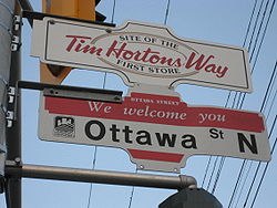
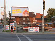
Hamilton became the birthplace of the Tim Hortons
Tim Hortons
Tim Hortons Inc. is a Canadian fast casual restaurant known for its coffee and doughnuts. It is also Canada's largest fast food service with over 3000 stores nationwide. It was founded in 1964 in Hamilton, Ontario, by Canadian hockey player Tim Horton and Jim Charade, after an initial venture in...
chain in 1964. The original store ("Store #1") still operates on Ottawa Street today. Ron Joyce
Ron Joyce
Ronald Vaughan "Ron" Joyce, CM is a Canadian billionaire businessman. He co-founded the Tim Hortons doughnut chain as Tim Horton's partner and first franchisee.-Early life and career:...
, was Tim Horton
Tim Horton
Myles Gilbert "Tim" Horton was a Canadian professional ice hockey defenceman. He played in 24 seasons in the National Hockey League for the Toronto Maple Leafs, New York Rangers, Pittsburgh Penguins, and Buffalo Sabres. He was also a businessman and a co-founder of Tim Hortons. He died in an...
's partner and first franchisee for his Canadian donut chain.
Centre Mall reconstruction project
Centre Mall owners announced plans for a 23-building super centre on the property on Barton Street EastBarton Street (Hamilton, Ontario)
Barton Street is an arterial road in the Lower City of Hamilton, Ontario, Canada. It's also the longest street in the city. It starts off at the Western end of town at Locke Street North and is a two-way street that stretches eastward through a number of different and varied communities in the...
. Cost is estimated to be around $100-million and will take up 700000 square feet (65,032.1 m²) of retail space. This will end up being the largest redevelopment project in the history of Hamilton's east-end. The overhaul will take about two-and-a-half years to complete but the bulk of the work is expected to be done by the end of the summer of 2008. Some new buildings will go up before the enclosed mall is torn down. The redevelopment of Centre Mall is transforming the entire neighbourhood from Ottawa to Kenilworth Avenue
Kenilworth Avenue (Hamilton, Ontario)
Kenilworth Avenue, is a Lower City arterial road in Hamilton, Ontario, Canada. It starts off at the Kenilworth Traffic Circle and Kenilworth Access, a mountain-access road at the base of the Niagara Escarpment and is a two-way street throughout stretching northward through the city's North End...
. The $100-million investment in the mall has boosted Ottawa Street North - already the city's No.1 tourist destination. The garment district has also morphed into a holistic home decor destination area, complete with lighting, antique, design & glass stores. The Ottawa Street B.I.A. had the most application and grants under the commercial property improvement program in 2007 with thirty three and it had an effect on the property values and real estate activity in the district.
Landmarks
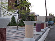
- Piers 18, 19, 20
- Dofasco, (steel company)
- site of the old Procter & Gamble (1913-1998) Manufacturing Company buildings & property.
- Canadian National railway tracks
- Centre MallCentre Mall (Hamilton)The Centre Mall was an outdoor shopping mall in the Lower City of Hamilton, Ontario, Canada, on Barton Street East bounded by Ottawa Street North in the western-end and Kenilworth Avenue North on the eastern-end.-History:...
, west end property, stretches East to Kenilworth Avenue North (Canada's first Mall), site of the old Jockey Club before Mall was built. - Ottawa Street Shopping District - "Garment & Textile District"
- Memorial Elementary School
- Tim HortonsTim HortonsTim Hortons Inc. is a Canadian fast casual restaurant known for its coffee and doughnuts. It is also Canada's largest fast food service with over 3000 stores nationwide. It was founded in 1964 in Hamilton, Ontario, by Canadian hockey player Tim Horton and Jim Charade, after an initial venture in...
, store #1 (1964), still in operation - Laidlaw United Church
- Escarpment Rail Trail (abandoned railway path)
- Bruce TrailBruce TrailThe Bruce Trail is a hiking trail in southern and central Ontario, Canada.-General:The trail follows the edge of the Niagara Escarpment, one of the thirteen UNESCO World Biosphere Reserves in Canada, for almost...
- Mountain Face Park
- Niagara EscarpmentNiagara EscarpmentThe Niagara Escarpment is a long escarpment, or cuesta, in the United States and Canada that runs westward from New York State, through Ontario, Michigan, Wisconsin and Illinois...
(mountain)
Communities
Note: Listing of neighbourhoods from North to South- North End - Everything north of the Canadian National Railway tracks
- Crown Point West/ Crown Point East
- Delta West/ Delta East
Major roads that cross Ottawa Street
Note: Listing of streets from North to South.- Industrial Drive - One way street (Westbound only)
- Burlington Street East - One way street (Eastbound only)
- Barton StreetBarton Street (Hamilton, Ontario)Barton Street is an arterial road in the Lower City of Hamilton, Ontario, Canada. It's also the longest street in the city. It starts off at the Western end of town at Locke Street North and is a two-way street that stretches eastward through a number of different and varied communities in the...
East - Cannon StreetCannon Street (Hamilton, Ontario)Cannon Street, is a Lower City collector road in Hamilton, Ontario, Canada. It starts off at Queen Street North as a one-way street up to Sherman Avenue North where it then switches over to a two-way street the rest of the way Eastward and ends just past Kenilworth Avenue North on Barons Avenue...
East - Main StreetMain Street (Hamilton, Ontario)Main Street, is a Lower City arterial road in Hamilton, Ontario, Canada. It starts east of Wilson Street in Ancaster at White Chapel Cemetery as a two-way street and switches over to a one-way street at Paradise Road South, in Westdale, where it continues up to the Delta where it once again...
East - King Street East crosses over Main Street East at the Delta by Gage Park and now is South of Main. - King Street East
- Cumberland Avenue - One way street (Eastbound Only), ends at Gage Avenue South
Roads that are parallel with Ottawa Street
- Ferguson AvenueFerguson Avenue (Hamilton, Ontario)Ferguson Avenue, is a Lower City collector road in Hamilton, Ontario, Canada. Is a two-way street throughout that starts off at the base of the Mountain on Foster Street. It's interrupted 3-blocks north at Corktown Park where Canadian Pacific Railway lines passes through it...
, North, South - Wellington StreetWellington Street (Hamilton, Ontario)Wellington Street, is a Lower City arterial road in Hamilton, Ontario, Canada. It starts off at Charlton Avenue East as a two-way street for only one block where it's then blocked off by the Corktown Park and a couple of Canadian National Railway lines that cut through it...
, North, South - Victoria AvenueVictoria Avenue (Hamilton, Ontario)Victoria Avenue, is a Lower City arterial road in Hamilton, Ontario, Canada. It starts off as a ramp and part of a Mountain-access road, the Claremont Access, on Hunter Street East in the Stinson neighbourhood...
, North, South - Wentworth StreetWentworth Street (Hamilton, Ontario)Wentworth Street, is a Lower City arterial road in Hamilton, Ontario, Canada. It starts off at the base of the Niagara Escarpment on Charlton Avenue East just before the CP lines as a two-way street for 2-blocks up past Cumberland Avenue up to Rutherford Avenue where it then switches over to a...
, North, South - Sherman AvenueSherman Avenue (Hamilton, Ontario)Sherman Avenue, is a Lower City collector road in Hamilton, Ontario, Canada. It starts off at the base of the Niagara Escarpment just south of Cumberland Avenue and is a one-way street northbound that cuts through the city's North End industrial neighbourhood and ends at Ship Street, the site of...
, North, South - Gage AvenueGage Avenue (Hamilton, Ontario)thumb|right|350px|Gage Park WaterfountainGage Avenue, is a Lower City arterial road in Hamilton, Ontario, Canada. It starts off at Lawrence Road at the base of the Niagara Escarpment at the south end of Gage Park...
, North, South - Ottawa Street, North, South
- Kenilworth AvenueKenilworth Avenue (Hamilton, Ontario)Kenilworth Avenue, is a Lower City arterial road in Hamilton, Ontario, Canada. It starts off at the Kenilworth Traffic Circle and Kenilworth Access, a mountain-access road at the base of the Niagara Escarpment and is a two-way street throughout stretching northward through the city's North End...
, North, South - Cochrane RoadCochrane Road (Hamilton, Ontario)Cochrane Road is a two-way Lower City collector road in Hamilton, Ontario, Canada. It starts off at the Queenston Traffic Circle and travels South between the Bartonville and Glenview neighbourhoods right through to the Rosedale neighbourhood where it ends at Greenhill Avenue in front of Rosedale...
- Parkdale AvenueParkdale Avenue (Hamilton, Ontario)Parkdale Avenue, is a Lower City arterial road in Hamilton, Ontario, Canada. It starts off just South of Lawrence Road at Hixon Road and is a two-way street throughout, stretching northward through the city's North End industrial neighbourhood and ends just north of the Burlington Street East...
, North, South - Red Hill Valley ParkwayRed Hill Valley ParkwayThe Red Hill Valley Parkway , referred to as the Red Hill Creek Expressway during planning is a municipal expressway in the Canadian city of Hamilton, Ontario. The route connects the Lincoln M. Alexander Parkway, Hamilton's second municipal expressway, to the Queen Elizabeth Way near Hamilton...
- Nash RoadNash Road (Hamilton, Ontario)Nash Road is a Lower City street in Hamilton, Ontario, Canada. It starts off at King Street East in front of the Father Sean O'Sullivan Memorial Park and is a two-way collector road throughout that extends north to the Nashdale neighbourhood past Bancroft Street where it then hangs a right and...
, North, South - Woodward AvenueWoodward Avenue (Hamilton, Ontario)Woodward Avenue is an arterial road in Hamilton, Ontario, Canada. It starts in the north-end as Eastport Drive and the road changes its name south of Burlington Street beside the Museum of Steam & Technology to Woodward Avenue and extends southward and ends at Melvin Avenue...
External links
- Ottawa Street B.I.A.
- North End Neighbours
- Hamilton Centre Mall
- Bruce Trail Association
- Hikes on the Bruce Trail
- Google Maps: Ottawa Street (Hybrid)