

Victoria Avenue (Hamilton, Ontario)
Encyclopedia
Hamilton, Ontario
Hamilton is a port city in the Canadian province of Ontario. Conceived by George Hamilton when he purchased the Durand farm shortly after the War of 1812, Hamilton has become the centre of a densely populated and industrialized region at the west end of Lake Ontario known as the Golden Horseshoe...
, Canada
Canada
Canada is a North American country consisting of ten provinces and three territories. Located in the northern part of the continent, it extends from the Atlantic Ocean in the east to the Pacific Ocean in the west, and northward into the Arctic Ocean...
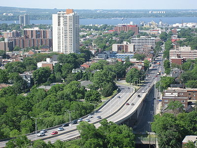
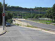
. It starts off as a ramp and part of a Mountain-access road, the Claremont Access, on Hunter Street East
Hunter Street (Hamilton, Ontario)
Hunter Street is a Lower City collector road in Hamilton, Ontario, Canada. It is a one-way street that starts West of Locke Street at Hill Street Park and ends two blocks East of Victoria Avenue at Emerald Street...
in the Stinson neighbourhood. It's also a one-way thoroughfare that flows north through the Landsdale and the city's North End industrial neighbourhood past Burlington Street East where it ends at Pier 11.
History
Victoria Avenue was named after Queen Victoria.In 1902 Canadian Otis Elevator Company
Otis Elevator Company
The Otis Elevator Company is the world's largest manufacturer of vertical transportation systems today, principally focusing on elevators and escalators...
(1902–1987) was formed (August 22) on Victoria Avenue North. For many years Hamilton, Ontario was home to the largest single elevator manufacturing facility in the world. The workers produced all kinds of elevators, escalators and later, forklifts. In 1969, the company took over the old Studebaker
Studebaker
Studebaker Corporation was a United States wagon and automobile manufacturer based in South Bend, Indiana. Founded in 1852 and incorporated in 1868 under the name of the Studebaker Brothers Manufacturing Company, the company was originally a producer of wagons for farmers, miners, and the...
plant. It was a return home for Otis, which had built the 350000 square feet (32,516.1 m²) facility for wartime production of anti-aircraft guns and other military equipment.

Studebaker
Studebaker Corporation was a United States wagon and automobile manufacturer based in South Bend, Indiana. Founded in 1852 and incorporated in 1868 under the name of the Studebaker Brothers Manufacturing Company, the company was originally a producer of wagons for farmers, miners, and the...
assembly line. (Studebaker Canada Ltd.
Studebaker Canada Ltd.
Studebaker of Canada Ltd. was the name given to Studebaker Corporation's Canadian manufacturing arm.While Studebaker produced cars in Canada prior to World War II, Studebaker's first modern automobile factory was established at Hamilton, Ontario in 1947, in an anti-aircraft gun plant purchased from...
) The company was located in the former Otis-Fenson military weapons factory off Burlington Street East, which was built in 1941. The Indiana
Indiana
Indiana is a US state, admitted to the United States as the 19th on December 11, 1816. It is located in the Midwestern United States and Great Lakes Region. With 6,483,802 residents, the state is ranked 15th in population and 16th in population density. Indiana is ranked 38th in land area and is...
-based Studebaker was looking for a Canadian site and settled on Hamilton because of its steel industry. The company was known for making automotive innovations and building solid distinctive cars
CARS
Cars, or automobiles, motor cars, are wheeled motor vehicles used for transporting passengers.Cars or CARS may also refer to:-Entertainment:* Cars , a Disney/Pixar film series...
. 1950 was its best year but the descent was quick. By 1954, Studebaker was in the red and merging with Packard
Packard
Packard was an American luxury-type automobile marque built by the Packard Motor Car Company of Detroit, Michigan, and later by the Studebaker-Packard Corporation of South Bend, Indiana...
, another falling car manufacturer. In 1963, the company moved its entire car operations to Hamilton. The Canadian car side had always been a money-maker and Studebaker was looking to curtail disastrous losses. That took the plant from a single to double shift — 48 to 96 cars daily. The last car to roll off the line was a turquoise Lark cruiser on March 4, 1966. Studebaker
Studebaker
Studebaker Corporation was a United States wagon and automobile manufacturer based in South Bend, Indiana. Founded in 1852 and incorporated in 1868 under the name of the Studebaker Brothers Manufacturing Company, the company was originally a producer of wagons for farmers, miners, and the...
officially shuts down the next day on March 5, 1966 as its last car factory. It was terrible news for the 700 workers who had formed a true family at the company, known for its employee parties and day trips. It was a huge blow to the city, too. Studebaker was Hamilton's 10th largest employer at the time.
Hamilton Health Sciences
Hamilton Health Sciences
Hamilton Health Sciences is a medical group of six unique hospitals and a cancer centre located in Hamilton, Ontario, Canada.-Composition:*Hamilton General Hospital*McMaster University Medical Centre*McMaster Children's Hospital*Chedoke Hospital*St...
is the largest employer in Hamilton with nearly 10,000 employees and serves approximately 2.2 million people in central south and central west Ontario
Ontario
Ontario is a province of Canada, located in east-central Canada. It is Canada's most populous province and second largest in total area. It is home to the nation's most populous city, Toronto, and the nation's capital, Ottawa....
. Hamilton Health Sciences is a family of five unique hospitals and a cancer centre, they include Chedoke Hospital, Hamilton General Hospital, Henderson General Hospital, McMaster Children's Hospital, McMaster University Medical Centre and the Juravinski Cancer Centre. Hamilton Health Sciences is affiliated with McMaster University's Faculty of Health Sciences. It is one of the most comprehensive health care
Health care
Health care is the diagnosis, treatment, and prevention of disease, illness, injury, and other physical and mental impairments in humans. Health care is delivered by practitioners in medicine, chiropractic, dentistry, nursing, pharmacy, allied health, and other care providers...
systems in Canada
Canada
Canada is a North American country consisting of ten provinces and three territories. Located in the northern part of the continent, it extends from the Atlantic Ocean in the east to the Pacific Ocean in the west, and northward into the Arctic Ocean...
.
The David Braley Cardiac, Vascular and Stroke Research Institute is a $90-million Research Centre that will be home to 500+ scientists and will be built right behind the Hamilton General Hospital. The new building with 165000 square feet (15,329 m²) is expected to open in 2010. At least 250 new jobs will be added to the local economy. David Braley
David Braley
David Braley is the owner of the B.C. Lions and Toronto Argonauts teams of the Canadian Football League. On May 20, 2010, he was appointed to the Canadian Senate where he sits as a Conservative.-Early life:...
contributed $10-million towards the project. Braley's donation marks an important transition in Hamilton's economy, as he takes money he made in the industrial economy and uses it to help the community develop a more diverse economic base. David Braley
David Braley
David Braley is the owner of the B.C. Lions and Toronto Argonauts teams of the Canadian Football League. On May 20, 2010, he was appointed to the Canadian Senate where he sits as a Conservative.-Early life:...
is the president of auto-parts manufacturer Orlick Industries Ltd., former owner of the Hamilton Tiger-Cats
Hamilton Tiger-Cats
The Hamilton Tiger-Cats are a Canadian Football League team based in Hamilton, Ontario, founded in 1950 with the merger of the Hamilton Tigers and the Hamilton Wildcats. The Tiger-Cats play their home games at Ivor Wynne Stadium...
and current owner of the B.C. Lions.
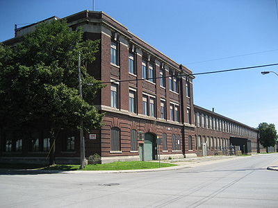
In recent years there has been talk of converting the 500000 square feet (46,451.5 m²) facility on Victoria Avenue North that was one time home of the Otis Elevator Company
Otis Elevator Company
The Otis Elevator Company is the world's largest manufacturer of vertical transportation systems today, principally focusing on elevators and escalators...
and Studebaker
Studebaker
Studebaker Corporation was a United States wagon and automobile manufacturer based in South Bend, Indiana. Founded in 1852 and incorporated in 1868 under the name of the Studebaker Brothers Manufacturing Company, the company was originally a producer of wagons for farmers, miners, and the...
plant into a Mega-Film Studio. In 2004 a group of local investors were ready to open up the $30-million facility named Hamilton Film Studios but pulled out 2-months after it opened up. One of the main reasons was they over-estimated the appeal of the site, in that the interior had too many support beams, making the space impractical for productions requiring wide, uninterrupted expanses.
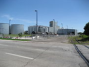
Bunge
Bunge Limited
Bunge Limited is a Bermudan food conglomerate with its headquarters in White Plains, New York. As well as being a leading global soybean exporter it is also involved in food processing, grain trading, and fertilizer...
is an oilseed processing plant and Canada’s largest canola
Canola
Canola refers to a cultivar of either Rapeseed or Field Mustard . Its seeds are used to produce edible oil suitable for consumption by humans and livestock. The oil is also suitable for use as biodiesel.Originally, Canola was bred naturally from rapeseed in Canada by Keith Downey and Baldur R...
processor. It has crushing facilities in Altona
Altona, Manitoba
Altona is a predominantly Mennonite town in southern Manitoba about 100 km south-west of Winnipeg and 133 km north of Grand Forks, North Dakota. It is surrounded by the Rural Municipality of Rhineland. Much of the surrounding area is devoted to farming and agriculture-based business. Its...
and Harrowby, Manitoba
Russell, Manitoba
Russell is a town of 1,428 located in southwestern Manitoba, Canada, in the Rural Municipality of Russell. The town of Russell is located along Highway 16 and Highway 83, and is at the western terminus of Highway 45. Russell is approximately 15 km from the Saskatchewan border and 340 km...
; Fort Saskatchewan, Alberta
Fort Saskatchewan, Alberta
Fort Saskatchewan is a city in Alberta, Canada, located northeast of downtown Edmonton, Alberta's capital city, along the North Saskatchewan River. Fort Saskatchewan is part of the Edmonton Census Metropolitan Area and is one of 24 municipalities on the Capital Region Board...
; and Nipawin, Saskatchewan
Nipawin, Saskatchewan
There is, however, some dispute regarding the current population of Nipawin, with Tourism Saskatchewan's Saskatchewan Discovery Guide 2010 claiming a population of 5,074, which actually places Nipawin over the population threshold for applying for city status....
in addition to the processing plant in Hamilton. The Hamilton plant serves food manufacturers, the biodiesel
Biodiesel
Biodiesel refers to a vegetable oil- or animal fat-based diesel fuel consisting of long-chain alkyl esters. Biodiesel is typically made by chemically reacting lipids with an alcohol....
industry and farmers in Ontario
Ontario
Ontario is a province of Canada, located in east-central Canada. It is Canada's most populous province and second largest in total area. It is home to the nation's most populous city, Toronto, and the nation's capital, Ottawa....
& Quebec
Quebec
Quebec or is a province in east-central Canada. It is the only Canadian province with a predominantly French-speaking population and the only one whose sole official language is French at the provincial level....
.
Landmarks
Note: Listing of Landmarks from North to South.- Pier 11
- BUNGEBunge LimitedBunge Limited is a Bermudan food conglomerate with its headquarters in White Plains, New York. As well as being a leading global soybean exporter it is also involved in food processing, grain trading, and fertilizer...
Processing plant (Canada’s largest canolaCanolaCanola refers to a cultivar of either Rapeseed or Field Mustard . Its seeds are used to produce edible oil suitable for consumption by humans and livestock. The oil is also suitable for use as biodiesel.Originally, Canola was bred naturally from rapeseed in Canada by Keith Downey and Baldur R...
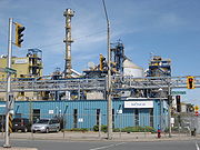
processor) - Vopak Terminals of Canada Inc. (liquid bulk storage)
- E.M.S. Operation Centre- Station 30City of Hamilton EMSHamilton Emergency Services - Emergency Medical Services Division is the designated service provider for emergency medical services in the City of Hamilton, Ontario....
- Otis Elevator Buildings (2), site of Otis Elevator CompanyOtis Elevator CompanyThe Otis Elevator Company is the world's largest manufacturer of vertical transportation systems today, principally focusing on elevators and escalators...
, (1902–1987) and Studebaker Canada Ltd.Studebaker Canada Ltd.Studebaker of Canada Ltd. was the name given to Studebaker Corporation's Canadian manufacturing arm.While Studebaker produced cars in Canada prior to World War II, Studebaker's first modern automobile factory was established at Hamilton, Ontario in 1947, in an anti-aircraft gun plant purchased from...
, (1948–1966) Today used as a warehouse by StelcoStelcoUS Steel Canada is a steel company based in Hamilton, Ontario, Canada.-History:Several existing smaller steelworks combined and were incorporated as the Steel Company of Canada in 1910. Charles S...
and various other North End industries. - Hamilton Community HEALTH CENTRE
- Trebor Allan Candy (factory), off Shaw Street, makers of Sour Patch KidsSour Patch KidsSour Patch Kids are a soft candy with a coating of sour sugar created by Paul Mihalick. When sour confectionery was first introduced it was not considered a serious product category, more of a children's fad. Success, however, rocketed it into the mainstream. One of the driving forces behind the...
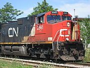
and candy canes. - Canadian National railway tracks
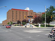
- Hamilton General Hospital Parking Complex (6-storey complex)
- David Braley Cardiac, Vascular and Stroke Research Institute (Under construction)
- Victoria Medical Centre building
- Hamilton Health Sciences Corporation Library building
- Hamilton Health SciencesHamilton Health SciencesHamilton Health Sciences is a medical group of six unique hospitals and a cancer centre located in Hamilton, Ontario, Canada.-Composition:*Hamilton General Hospital*McMaster University Medical Centre*McMaster Children's Hospital*Chedoke Hospital*St...
- Hamilton General HospitalHamilton General HospitalThe Hamilton General Hospital is a major teaching hospital in downtown Hamilton, Canada, on the corners of Barton Street East and Victoria Avenue North... - Romanian Baptist Church
- Apostolic Christian Church
- Jack C Beemer Park
- King William apartments (10-storey building)
- St.Patrick's Roman Catholic Church
- Versa-Care Centre (8-storey building)
- Donna Court, (9-storey apartment building)
- Canadian Action Group Youth Employment Centre
- Victoria Manor I & II (retirement homes)
- Victoria Avenue ramp (Mountain-access), turns into the Claremont Access Road
Communities
Note: Listing of neighbourhoods from North to South- North End — Everything north of the Canadian National Railway tracks
- Landsdale
- Stinson
Major roads that cross Victoria Avenue
- Burlington Street East
- Barton StreetBarton Street (Hamilton, Ontario)Barton Street is an arterial road in the Lower City of Hamilton, Ontario, Canada. It's also the longest street in the city. It starts off at the Western end of town at Locke Street North and is a two-way street that stretches eastward through a number of different and varied communities in the...
East - Cannon StreetCannon Street (Hamilton, Ontario)Cannon Street, is a Lower City collector road in Hamilton, Ontario, Canada. It starts off at Queen Street North as a one-way street up to Sherman Avenue North where it then switches over to a two-way street the rest of the way Eastward and ends just past Kenilworth Avenue North on Barons Avenue...
East — One way street (Westbound only) - Wilson StreetWilson Street (Hamilton, Ontario)Wilson Street is a Lower City collector road in Hamilton, Ontario, Canada. It starts off at James Street North and works its way East and ends at Sherman Avenue North...
— One way street (Eastbound Only) - King William StreetKing William Street (Hamilton, Ontario)400px|thumb|Theatre AquariusKing William Street is a Lower City collector road in Hamilton, Ontario, Canada. It starts off at the western-end at James Street North and is a one-way street until Mary Street, where it becomes a two-way street that ends at Wentworth Street North.-History:In 1922,...
— One way street (Eastbound Only) - King Street East — One way street (Westbound Only)
- Main StreetMain Street (Hamilton, Ontario)Main Street, is a Lower City arterial road in Hamilton, Ontario, Canada. It starts east of Wilson Street in Ancaster at White Chapel Cemetery as a two-way street and switches over to a one-way street at Paradise Road South, in Westdale, where it continues up to the Delta where it once again...
East — One way street (Eastbound Only) - Hunter StreetHunter Street (Hamilton, Ontario)Hunter Street is a Lower City collector road in Hamilton, Ontario, Canada. It is a one-way street that starts West of Locke Street at Hill Street Park and ends two blocks East of Victoria Avenue at Emerald Street...
East — One way street (Westbound Only) - Charlton AvenueCharlton Avenue (Hamilton, Ontario)Charlton Avenue, is a Lower City collector road in Hamilton, Ontario, Canada. This collector road starts of just West of Dundurn Street as a one-way street up to James Street South where it then switches over to a two-way street the rest of the way eastward and ends at Wentworth Street South right...
East — One way street (Westbound Only), flows underneath Victoria Avenue Mountain-access ramp (Claremont Access)
Roads that are parallel with Victoria Avenue
- James StreetJames Street (Hamilton, Ontario)James Street is a Lower City arterial road in Hamilton, Ontario, Canada. It starts off at the base of the Niagara Escarpment from James Mountain Road, a mountain-access road in the city, originally was a one-way street going south throughout but now has sections of it that are two-way...
, North, South - Hughson StreetHughson Street (Hamilton, Ontario)Hughson Street is a Lower City collector road in Hamilton, Ontario, Canada. It starts at Charlton Avenue East at St. Joseph's hospital and runs north to Haymarket Street in the downtown where it's cut off by the Hamilton GO Transit station. Up to this point it is a two-way street...
, North, South - John StreetJohn Street (Hamilton, Ontario)John Street, is a Lower City arterial road in Hamilton, Ontario, Canada. Originally it was known as Mountain Road or Ancaster Road. It starts off at the base of Arkledun Avenue, a Mountain-access road in the city, just east of St.Joseph's Hospital where it's a one-way street going north and tunnels...
, North, South - Catharine StreetCatharine Street (Hamilton, Ontario)Catharine Street, is a Lower City collector road in Hamilton, Ontario, Canada. It starts off at Charlton Avenue East at Woolverton Park in the Corktown neighbourhood as a one-way street , tunnels underneath the Hunter Street Railway bridge and stretches up to Barton Street East where it then turns...
, North, South - Ferguson AvenueFerguson Avenue (Hamilton, Ontario)Ferguson Avenue, is a Lower City collector road in Hamilton, Ontario, Canada. Is a two-way street throughout that starts off at the base of the Mountain on Foster Street. It's interrupted 3-blocks north at Corktown Park where Canadian Pacific Railway lines passes through it...
, North, South - Wellington StreetWellington Street (Hamilton, Ontario)Wellington Street, is a Lower City arterial road in Hamilton, Ontario, Canada. It starts off at Charlton Avenue East as a two-way street for only one block where it's then blocked off by the Corktown Park and a couple of Canadian National Railway lines that cut through it...
, North, South - Victoria Avenue, North, South
- Wentworth StreetWentworth Street (Hamilton, Ontario)Wentworth Street, is a Lower City arterial road in Hamilton, Ontario, Canada. It starts off at the base of the Niagara Escarpment on Charlton Avenue East just before the CP lines as a two-way street for 2-blocks up past Cumberland Avenue up to Rutherford Avenue where it then switches over to a...
, North, South - Sherman AvenueSherman Avenue (Hamilton, Ontario)Sherman Avenue, is a Lower City collector road in Hamilton, Ontario, Canada. It starts off at the base of the Niagara Escarpment just south of Cumberland Avenue and is a one-way street northbound that cuts through the city's North End industrial neighbourhood and ends at Ship Street, the site of...
, North, South - Gage AvenueGage Avenue (Hamilton, Ontario)thumb|right|350px|Gage Park WaterfountainGage Avenue, is a Lower City arterial road in Hamilton, Ontario, Canada. It starts off at Lawrence Road at the base of the Niagara Escarpment at the south end of Gage Park...
, North, South - Ottawa StreetOttawa Street (Hamilton, Ontario)Ottawa street, is a Lower City arterial road in Hamilton, Ontario, Canada. It starts off at Lawrence Road at the base of the Niagara Escarpment and is a two-way street throughout cutting through the Delta and Crown Point neighbourhoods and the City's North End industrial neighbourhood...
, North, South - Kenilworth AvenueKenilworth Avenue (Hamilton, Ontario)Kenilworth Avenue, is a Lower City arterial road in Hamilton, Ontario, Canada. It starts off at the Kenilworth Traffic Circle and Kenilworth Access, a mountain-access road at the base of the Niagara Escarpment and is a two-way street throughout stretching northward through the city's North End...
, North, South - Cochrane RoadCochrane Road (Hamilton, Ontario)Cochrane Road is a two-way Lower City collector road in Hamilton, Ontario, Canada. It starts off at the Queenston Traffic Circle and travels South between the Bartonville and Glenview neighbourhoods right through to the Rosedale neighbourhood where it ends at Greenhill Avenue in front of Rosedale...