

Ferguson Avenue (Hamilton, Ontario)
Encyclopedia
Ferguson Avenue, is a Lower City collector road in Hamilton, Ontario
Hamilton, Ontario
Hamilton is a port city in the Canadian province of Ontario. Conceived by George Hamilton when he purchased the Durand farm shortly after the War of 1812, Hamilton has become the centre of a densely populated and industrialized region at the west end of Lake Ontario known as the Golden Horseshoe...
, Canada
Canada
Canada is a North American country consisting of ten provinces and three territories. Located in the northern part of the continent, it extends from the Atlantic Ocean in the east to the Pacific Ocean in the west, and northward into the Arctic Ocean...
. Is a two-way street
Two-way street
A two-way street is a street that allows vehicles to travel in both directions. On most two-way streets, especially main streets, a line is painted down the middle of the road to remind drivers to stay on their side of the road. Sometimes one portion of a street is two-way, the other portion one-way...
throughout that starts off at the base of the Mountain (Niagara Escarpment) on Foster Street. It's interrupted 3-blocks north at Corktown Park where Canadian Pacific Railway lines passes through it. Ferguson Avenue resumes again north of the Park right before Hunter Street East, extending northward past Barton Street East through the city's North End industrial neighbourhood where it ends on Dock Service Road, the site of a Royal Canadian Navy base and Pier 10.
History
In the early years, Ferguson Street formed the eastern boundary of Hamilton.
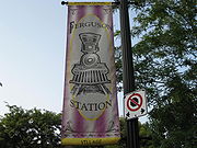
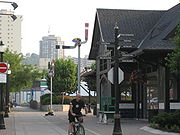
Ferguson Station is a defunct train station in downtown Hamilton. It used to be the Hamilton terminal for the Grand Trunk Railway
Grand Trunk Railway
The Grand Trunk Railway was a railway system which operated in the Canadian provinces of Quebec and Ontario, as well as the American states of Connecticut, Maine, Michigan, Massachusetts, New Hampshire, and Vermont. The railway was operated from headquarters in Montreal, Quebec; however, corporate...
Company. There was also a railyard north and south of this station. The North yard was on Ferguson Avenue
between Cannon Street East
Cannon Street (Hamilton, Ontario)
Cannon Street, is a Lower City collector road in Hamilton, Ontario, Canada. It starts off at Queen Street North as a one-way street up to Sherman Avenue North where it then switches over to a two-way street the rest of the way Eastward and ends just past Kenilworth Avenue North on Barons Avenue...
and Barton Street East
Barton Street (Hamilton, Ontario)
Barton Street is an arterial road in the Lower City of Hamilton, Ontario, Canada. It's also the longest street in the city. It starts off at the Western end of town at Locke Street North and is a two-way street that stretches eastward through a number of different and varied communities in the...
. The South yard was on Ferguson Avenue at Young Street. Ferguson Avenue south of Main Street used to be called, Cherry Street. Back in its day, Ferguson Station was referred to as the "King Street Station". Freight rail service continued on a line running down the middle of Ferguson Avenue until the mid-1980s.
On July 25, 2008, a newly constructed bridge opened up on Ferguson Avenue North, just north of Barton Street East, to Simcoe Street East. This part of Ferguson was separated by CN
Canadian National Railway
The Canadian National Railway Company is a Canadian Class I railway headquartered in Montreal, Quebec. CN's slogan is "North America's Railroad"....
railway tracks and better connects the downtown to Hamilton's waterfront. The $4.6 million construction project began in November 2006 and includes one lane of traffic in each direction, bicycle lanes and sidewalks. This project is also in line with Hamilton’s recently adopted Transportation Master Plan which emphasizes enhanced cycling and walking facilities and an efficient road network to support economic development
Economic development
Economic development generally refers to the sustained, concerted actions of policymakers and communities that promote the standard of living and economic health of a specific area...
. This construction project received federal funding through the Federal Gas Tax Fund
Fuel taxes in Canada
In Canada, motor vehicles are primarily powered by gasoline or diesel fuel. Other energy sources include ethanol, biodiesel, propane, compressed natural gas , electric batteries charged from an external source, and hydrogen...
.
Festivals
Hamilton is home to the Mustard Festival because Hamilton is home to the largest miller of dry mustard in the world. It's held annually on Labour DayLabour Day
Labour Day or Labor Day is an annual holiday to celebrate the economic and social achievements of workers. Labour Day has its origins in the labour union movement, specifically the eight-hour day movement, which advocated eight hours for work, eight hours for recreation, and eight hours for...
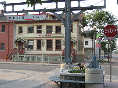
weekend at Ferguson Station at Hamilton's International Village and is another summertime food & beverage festival that features some of the top Blues and Jazz acts in the region.
Landmarks
- Pier 10
- Royal Canadian NavyRoyal Canadian NavyThe history of the Royal Canadian Navy goes back to 1910, when the naval force was created as the Naval Service of Canada and renamed a year later by King George V. The Royal Canadian Navy is one of the three environmental commands of the Canadian Forces...
, Army and Sea Cadets - Ferrie Street Park
- Simcoe Street Park
- Ferguson Avenue bridge/overpass, Canadian National railway tracks
- Hamilton Regional Detention Centre (Barton street jail)
- Hamilton Regional Police stationHamilton Police Service (Ontario)The Hamilton Police Service, formerly The Hamilton Wentworth Regional Police, is the local police service for the City of Hamilton, Ontario, Canada. This agency is the primary service charged with the duty of enforcing the Criminal Code of Canada in the City of Hamilton. The organization became a...
- Theatre Aquarius
- Beasley ParkBeasley Park (Hamilton, Ontario)Beasley Park is a park in the Lower City of Hamilton, Ontario, Canada and named after Richard Beasley, , a soldier, political figure, farmer and businessman in Upper Canada. Richard Beasley was one of Hamilton's first settlers who came to Canada from New York in 1777...
- Beasley Park Community Centre
- Ferguson Station (historic site)- defunct Grand Trunk RailwayGrand Trunk RailwayThe Grand Trunk Railway was a railway system which operated in the Canadian provinces of Quebec and Ontario, as well as the American states of Connecticut, Maine, Michigan, Massachusetts, New Hampshire, and Vermont. The railway was operated from headquarters in Montreal, Quebec; however, corporate...
train station, site of the summertime Mustard Festival - International Village (shopping district)
- Escarpment Rail Trail (abandoned railway path)
- Corktown Park
- Shamrock Park
- Bruce TrailBruce TrailThe Bruce Trail is a hiking trail in southern and central Ontario, Canada.-General:The trail follows the edge of the Niagara Escarpment, one of the thirteen UNESCO World Biosphere Reserves in Canada, for almost...
- Niagara EscarpmentNiagara EscarpmentThe Niagara Escarpment is a long escarpment, or cuesta, in the United States and Canada that runs westward from New York State, through Ontario, Michigan, Wisconsin and Illinois...
(mountain)
Communities
Note: Listing of neighbourhoods from North to South- North End - Everything north of the Canadian National Railway tracks
- Beasley
- Corktown
Major roads that cross Ferguson Avenue
- Burlington Street East
- Barton StreetBarton Street (Hamilton, Ontario)Barton Street is an arterial road in the Lower City of Hamilton, Ontario, Canada. It's also the longest street in the city. It starts off at the Western end of town at Locke Street North and is a two-way street that stretches eastward through a number of different and varied communities in the...
East - Cannon StreetCannon Street (Hamilton, Ontario)Cannon Street, is a Lower City collector road in Hamilton, Ontario, Canada. It starts off at Queen Street North as a one-way street up to Sherman Avenue North where it then switches over to a two-way street the rest of the way Eastward and ends just past Kenilworth Avenue North on Barons Avenue...
East - One way street (Westbound only) - Wilson StreetWilson Street (Hamilton, Ontario)Wilson Street is a Lower City collector road in Hamilton, Ontario, Canada. It starts off at James Street North and works its way East and ends at Sherman Avenue North...
- One way street (Eastbound Only) - King William StreetKing William Street (Hamilton, Ontario)400px|thumb|Theatre AquariusKing William Street is a Lower City collector road in Hamilton, Ontario, Canada. It starts off at the western-end at James Street North and is a one-way street until Mary Street, where it becomes a two-way street that ends at Wentworth Street North.-History:In 1922,...
- One way street (Eastbound Only) - King Street East - One way street (Westbound Only)
- Main StreetMain Street (Hamilton, Ontario)Main Street, is a Lower City arterial road in Hamilton, Ontario, Canada. It starts east of Wilson Street in Ancaster at White Chapel Cemetery as a two-way street and switches over to a one-way street at Paradise Road South, in Westdale, where it continues up to the Delta where it once again...
East - One way street (Eastbound Only) - Jackson StreetJackson Street (Hamilton, Ontario)Jackson Street, is a Lower City collector road in Hamilton, Ontario, Canada. It starts off West of Locke Street South at Jackson Playground as a one-way street up to Queen Street South where it then switches over to a two-way street and is interrupted at Bay Street South the site of the Hamilton...
East - Hunter StreetHunter Street (Hamilton, Ontario)Hunter Street is a Lower City collector road in Hamilton, Ontario, Canada. It is a one-way street that starts West of Locke Street at Hill Street Park and ends two blocks East of Victoria Avenue at Emerald Street...
East - One way street (Westbound Only) - Charlton AvenueCharlton Avenue (Hamilton, Ontario)Charlton Avenue, is a Lower City collector road in Hamilton, Ontario, Canada. This collector road starts of just West of Dundurn Street as a one-way street up to James Street South where it then switches over to a two-way street the rest of the way eastward and ends at Wentworth Street South right...
East - One way street (Westbound Only)
Roads that are parallel with Ferguson Avenue
Note: Listing of streets from West to East.- Bay StreetBay Street (Hamilton)Bay Street is a Lower City arterial road in Hamilton, Ontario, Canada. It starts at Inglewood Drive, just South of Aberdeen Avenue, as a collector road with only two lanes, then eventually becomes a six lane thoroughfare at its peak. Bay Street also passes through Downtown Hamilton, where many...
, North, South - MacNab StreetMacNab Street (Hamilton, Ontario)MacNab Street, is a Lower City collector road in Hamilton, Ontario, Canada. It starts in the Durand neighbourhood on Markland Street, as a one-way street going north to Bold Street, where it becomes two-way for one block until Hurst Place where it's cut off by a wall for the Hunter Street railway...
, North, South - James StreetJames Street (Hamilton, Ontario)James Street is a Lower City arterial road in Hamilton, Ontario, Canada. It starts off at the base of the Niagara Escarpment from James Mountain Road, a mountain-access road in the city, originally was a one-way street going south throughout but now has sections of it that are two-way...
, North, South - Hughson StreetHughson Street (Hamilton, Ontario)Hughson Street is a Lower City collector road in Hamilton, Ontario, Canada. It starts at Charlton Avenue East at St. Joseph's hospital and runs north to Haymarket Street in the downtown where it's cut off by the Hamilton GO Transit station. Up to this point it is a two-way street...
, North, South - John StreetJohn Street (Hamilton, Ontario)John Street, is a Lower City arterial road in Hamilton, Ontario, Canada. Originally it was known as Mountain Road or Ancaster Road. It starts off at the base of Arkledun Avenue, a Mountain-access road in the city, just east of St.Joseph's Hospital where it's a one-way street going north and tunnels...
, North, South - Catharine StreetCatharine Street (Hamilton, Ontario)Catharine Street, is a Lower City collector road in Hamilton, Ontario, Canada. It starts off at Charlton Avenue East at Woolverton Park in the Corktown neighbourhood as a one-way street , tunnels underneath the Hunter Street Railway bridge and stretches up to Barton Street East where it then turns...
, North, South - Ferguson Avenue, North, South
- Wellington StreetWellington Street (Hamilton, Ontario)Wellington Street, is a Lower City arterial road in Hamilton, Ontario, Canada. It starts off at Charlton Avenue East as a two-way street for only one block where it's then blocked off by the Corktown Park and a couple of Canadian National Railway lines that cut through it...
, North, South - Victoria AvenueVictoria Avenue (Hamilton, Ontario)Victoria Avenue, is a Lower City arterial road in Hamilton, Ontario, Canada. It starts off as a ramp and part of a Mountain-access road, the Claremont Access, on Hunter Street East in the Stinson neighbourhood...
, North, South - Wentworth StreetWentworth Street (Hamilton, Ontario)Wentworth Street, is a Lower City arterial road in Hamilton, Ontario, Canada. It starts off at the base of the Niagara Escarpment on Charlton Avenue East just before the CP lines as a two-way street for 2-blocks up past Cumberland Avenue up to Rutherford Avenue where it then switches over to a...
, North, South - Sherman AvenueSherman Avenue (Hamilton, Ontario)Sherman Avenue, is a Lower City collector road in Hamilton, Ontario, Canada. It starts off at the base of the Niagara Escarpment just south of Cumberland Avenue and is a one-way street northbound that cuts through the city's North End industrial neighbourhood and ends at Ship Street, the site of...
, North, South - Gage AvenueGage Avenue (Hamilton, Ontario)thumb|right|350px|Gage Park WaterfountainGage Avenue, is a Lower City arterial road in Hamilton, Ontario, Canada. It starts off at Lawrence Road at the base of the Niagara Escarpment at the south end of Gage Park...
, North, South - Ottawa StreetOttawa Street (Hamilton, Ontario)Ottawa street, is a Lower City arterial road in Hamilton, Ontario, Canada. It starts off at Lawrence Road at the base of the Niagara Escarpment and is a two-way street throughout cutting through the Delta and Crown Point neighbourhoods and the City's North End industrial neighbourhood...
, North, South
External links
- Beasley Neighbourhood (ourbeasley.com)
- International Village
- North End Neighbours
- Bruce Trail Association
- Hikes on the Bruce Trail
- Google Maps: Ferguson Avenue (Hybrid)