

Queen Street (Hamilton, Ontario)
Encyclopedia
Hamilton, Ontario
Hamilton is a port city in the Canadian province of Ontario. Conceived by George Hamilton when he purchased the Durand farm shortly after the War of 1812, Hamilton has become the centre of a densely populated and industrialized region at the west end of Lake Ontario known as the Golden Horseshoe...
, Canada
Canada
Canada is a North American country consisting of ten provinces and three territories. Located in the northern part of the continent, it extends from the Atlantic Ocean in the east to the Pacific Ocean in the west, and northward into the Arctic Ocean...
. It starts off at Beckett Drive, a mountain-access road in the city and is a two-way street up to Herkimer Street and a one-way street (Southbound) the rest of the way north up to the Canadian National Railway Yard where the road turns right, merging with Stuart Street which travels in a West-East direction.
History
Queen Street was named after Queen Caroline of BrunswickCaroline of Brunswick
Caroline of Brunswick-Wolfenbüttel was the Queen consort of King George IV of the United Kingdom from 29 January 1820 until her death...
, wife of King George IV.
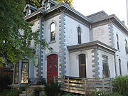
Queen Street forms the western boundary line of the Durand neighbourhood. Durand is also bounded by Main Street
Main Street (Hamilton, Ontario)
Main Street, is a Lower City arterial road in Hamilton, Ontario, Canada. It starts east of Wilson Street in Ancaster at White Chapel Cemetery as a two-way street and switches over to a one-way street at Paradise Road South, in Westdale, where it continues up to the Delta where it once again...
to the north, James Street
James Street (Hamilton, Ontario)
James Street is a Lower City arterial road in Hamilton, Ontario, Canada. It starts off at the base of the Niagara Escarpment from James Mountain Road, a mountain-access road in the city, originally was a one-way street going south throughout but now has sections of it that are two-way...
and James Mountain Road to the east and the Niagara escarpment
Niagara Escarpment
The Niagara Escarpment is a long escarpment, or cuesta, in the United States and Canada that runs westward from New York State, through Ontario, Michigan, Wisconsin and Illinois...
to the south. With the turn of the 20th century, luxurious new residences were built along Markland and Aberdeen Avenues
Aberdeen Avenue (Hamilton, Ontario)
Aberdeen Avenue is a Lower City arterial road in Hamilton, Ontario, Canada. It starts off just West of Longwood Road South and East of Highway 403 as a two-way thoroughfare up to Queen Street South where it then switches over to a one-way collector road to Bay Street South and then to another...
and to the south in the lee of the escarpment. These residences reflected the entrepreneurial spirit of those who made their fortunes in transportation, finance
Finance
"Finance" is often defined simply as the management of money or “funds” management Modern finance, however, is a family of business activity that includes the origination, marketing, and management of cash and money surrogates through a variety of capital accounts, instruments, and markets created...
, industry
Industry
Industry refers to the production of an economic good or service within an economy.-Industrial sectors:There are four key industrial economic sectors: the primary sector, largely raw material extraction industries such as mining and farming; the secondary sector, involving refining, construction,...
, and commerce
Commerce
While business refers to the value-creating activities of an organization for profit, commerce means the whole system of an economy that constitutes an environment for business. The system includes legal, economic, political, social, cultural, and technological systems that are in operation in any...
in one of North America
North America
North America is a continent wholly within the Northern Hemisphere and almost wholly within the Western Hemisphere. It is also considered a northern subcontinent of the Americas...
s major centres, Hamilton. By 1920, the Durand neighbourhood was considered to be the “exclusive” neighbourhood in Hamilton. However, the Great Depression
Great Depression
The Great Depression was a severe worldwide economic depression in the decade preceding World War II. The timing of the Great Depression varied across nations, but in most countries it started in about 1929 and lasted until the late 1930s or early 1940s...
and the Second World War
World War II
World War II, or the Second World War , was a global conflict lasting from 1939 to 1945, involving most of the world's nations—including all of the great powers—eventually forming two opposing military alliances: the Allies and the Axis...
took their tolls on the fortunes of many of the established Durand households. Owners could no longer afford the taxes and upkeep on their homes, and many of the grander residences were either demolished and replaced with middle-class low-rise housing, or were renovated to become low-rise apartment buildings. Fortunately, much of the heritage of the neighbourhood survives today.

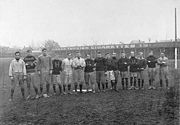
Hamilton Amateur Athletic Association Grounds
The Hamilton Amateur Athletic Association Grounds is a park located on the north side of Charlton Avenue West,between Locke Street South and Queen Street South, in Hamilton, Ontario, Canada. The park served as home to the Hamilton Tigers from 1872-1949...
), is a park that was home to the Hamilton Tiger-Cats
Hamilton Tiger-Cats
The Hamilton Tiger-Cats are a Canadian Football League team based in Hamilton, Ontario, founded in 1950 with the merger of the Hamilton Tigers and the Hamilton Wildcats. The Tiger-Cats play their home games at Ivor Wynne Stadium...
from 1872-1949. Entrance to the park at Queen Street South is right before Charlton Avenue West. Today it is also the site of the Hamilton Tennis Club. Today Ivor Wynne Stadium
Ivor Wynne Stadium
Ivor Wynne Stadium is a Canadian football stadium located at the corner of Balsam and Beechwood Avenues, two blocks west of Gage Avenue North in Hamilton, Ontario, Canada...
is the home of the Hamilton Tiger-Cats
Hamilton Tiger-Cats
The Hamilton Tiger-Cats are a Canadian Football League team based in Hamilton, Ontario, founded in 1950 with the merger of the Hamilton Tigers and the Hamilton Wildcats. The Tiger-Cats play their home games at Ivor Wynne Stadium...
. It's off of Beachwood Avenue, 2-blocks West of Gage Avenue North
Gage Avenue (Hamilton, Ontario)
thumb|right|350px|Gage Park WaterfountainGage Avenue, is a Lower City arterial road in Hamilton, Ontario, Canada. It starts off at Lawrence Road at the base of the Niagara Escarpment at the south end of Gage Park...
.
The TH&B Railway came into Hamilton in 1895. A railway tunnel was then constructed from Queen to Park Street to cut down on the noise, pollution and disruption for the wealthy families who lived South of Jackson Street
Jackson Street (Hamilton, Ontario)
Jackson Street, is a Lower City collector road in Hamilton, Ontario, Canada. It starts off West of Locke Street South at Jackson Playground as a one-way street up to Queen Street South where it then switches over to a two-way street and is interrupted at Bay Street South the site of the Hamilton...
in the Durand neighbourhood.
In 1964, Imperial Tobacco Company's Hamilton operations are moved to Guelph
Guelph
Guelph is a city in Ontario, Canada.Guelph may also refer to:* Guelph , consisting of the City of Guelph, Ontario* Guelph , as the above* University of Guelph, in the same city...
, Ontario
Ontario
Ontario is a province of Canada, located in east-central Canada. It is Canada's most populous province and second largest in total area. It is home to the nation's most populous city, Toronto, and the nation's capital, Ottawa....
. Originally it was known as the Tuckett Tobacco Company which was started up by George Elias Tuckett
George Elias Tuckett
George Elias Tuckett was mayor of Hamilton, Ontario in 1896.Tuckett built a fortune during the American Civil War, cornering a chunk of the tobacco market. He also founded the Tuckett Tobacco Company in 1857...
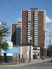
, (1835-1900), who was also Hamilton's 27th Mayor in 1896. Today the property is the site of two high-rise apartment buildings, Queen's Terrace and Oxford Heights. Tuckett's home was the Scottish Rite Castle, also on Queen Street, remains as one of Hamilton's most magnificent structures. At its peak the Tuckett Tobacco Company employed 600 workers and products were sold throughout the world. The first factory opened up in the 1860s near the intersection of King and Bay Streets
Bay Street (Hamilton)
Bay Street is a Lower City arterial road in Hamilton, Ontario, Canada. It starts at Inglewood Drive, just South of Aberdeen Avenue, as a collector road with only two lanes, then eventually becomes a six lane thoroughfare at its peak. Bay Street also passes through Downtown Hamilton, where many...
. The Queen Street North factory opened up 28 February, 1891 and stayed opened until 17 September, 1966.
Bruce Trail
One can reach the Bruce TrailBruce Trail
The Bruce Trail is a hiking trail in southern and central Ontario, Canada.-General:The trail follows the edge of the Niagara Escarpment, one of the thirteen UNESCO World Biosphere Reserves in Canada, for almost...
via Queen Street South. The trail cuts through the city along the Niagara Escarpment
Niagara Escarpment
The Niagara Escarpment is a long escarpment, or cuesta, in the United States and Canada that runs westward from New York State, through Ontario, Michigan, Wisconsin and Illinois...
(mountain) and used by many locals for a full days hike. The Trail is 430 miles (692 km) long and starts at Niagara Falls
Niagara Falls, Ontario
Niagara Falls is a Canadian city on the Niagara River in the Golden Horseshoe region of Southern Ontario. The municipality was incorporated on June 12, 1903...
, passes through Hamilton and ends at the Bruce Peninsula
Bruce Peninsula
The Bruce Peninsula is a peninsula in Ontario, Canada that lies between Georgian Bay and the main basin of Lake Huron. The peninsula extends roughly northwestwards from the rest of Southern Ontario, pointing towards Manitoulin Island, with which it forms the widest strait joining Georgian Bay to...
. Hikers are led to scenic gorges, hidden waterfalls and places of quiet charm.
Landmarks
Note: Listing of Landmarks from North to South.- Canadian National RailwayCanadian National RailwayThe Canadian National Railway Company is a Canadian Class I railway headquartered in Montreal, Quebec. CN's slogan is "North America's Railroad"....
Yards - A City Window & Glass, building
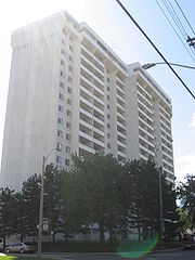
- Queen's Terrace/ Oxford Heights (25 & 20 storey building apartments)
- Gary Hill Parkette (park)
- Queen 75 (22 storey condominium tower)
- Queen Elizabeth Tower (18 storey apartment building)
- All Saints Church, Hamilton, OntarioAll Saints Church, Hamilton, OntarioAll Saints Church, is located in Hamilton, Ontario, on Queen Street South at King Street West.-History:The establishment of the church parish dates to 1855, while the construction of the present building began in 1872....
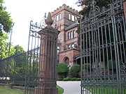
- Scottish Rite Castle, Originally the home of George Elias TuckettGeorge Elias TuckettGeorge Elias Tuckett was mayor of Hamilton, Ontario in 1896.Tuckett built a fortune during the American Civil War, cornering a chunk of the tobacco market. He also founded the Tuckett Tobacco Company in 1857...
, (1835-1900), Tuckett Tobacco Company owner + Hamilton's 27th Mayor in 1896.- Grand Lodge of Canada, behind the Scottish Rite Castle on King Street West
- Canadian Pacific RailwayCanadian Pacific RailwayThe Canadian Pacific Railway , formerly also known as CP Rail between 1968 and 1996, is a historic Canadian Class I railway founded in 1881 and now operated by Canadian Pacific Railway Limited, which began operations as legal owner in a corporate restructuring in 2001...
tunnel, (Tunnel extends from Queen to Park Street) - Hess Village, Western end of George Street.
- Queen's Court, (2 building blocks, 3-stories each)
- Players' Guild of Hamilton, Inc. (theatre)
- Jackson Villa, (12-storey apartment building)
- Queensvilla Condominiums
- Capital Terrace, (20-storey apartment building)
- Savaria Tower, (14-storey apartment building)
- Pannonia Tower, (18-storey apartment building)
- Hamilton Amateur Athletic Association GroundsHamilton Amateur Athletic Association GroundsThe Hamilton Amateur Athletic Association Grounds is a park located on the north side of Charlton Avenue West,between Locke Street South and Queen Street South, in Hamilton, Ontario, Canada. The park served as home to the Hamilton Tigers from 1872-1949...
- Hamilton Tennis Club
- Beckett Drive, a Mountain-access road
- Bruce TrailBruce TrailThe Bruce Trail is a hiking trail in southern and central Ontario, Canada.-General:The trail follows the edge of the Niagara Escarpment, one of the thirteen UNESCO World Biosphere Reserves in Canada, for almost...
- Niagara EscarpmentNiagara EscarpmentThe Niagara Escarpment is a long escarpment, or cuesta, in the United States and Canada that runs westward from New York State, through Ontario, Michigan, Wisconsin and Illinois...
(mountain)
Communities
Note: Listing of neighbourhoods from North to South- StrathconaStrathcona (Hamilton, Ontario)The Strathcona Neighbourhood is located west of downtown Hamilton, Ontario and is bounded by Highway 403, the CNR rail line, Queen Street York Boulevard and Main Street. The neighbourhood is also intersected by several other major street arteries: Dundurn Street , Locke Street, and King Street West...
/ Central - (The financial center of Hamilton), Queen Street is the division between these two neighbourhoods. - Kirkendall North/ Durand, Queen Street is the division between these two neighbourhoods.
- Kirkendall South
Major roads that cross Queen Street
- Barton StreetBarton Street (Hamilton, Ontario)Barton Street is an arterial road in the Lower City of Hamilton, Ontario, Canada. It's also the longest street in the city. It starts off at the Western end of town at Locke Street North and is a two-way street that stretches eastward through a number of different and varied communities in the...
West - Cannon StreetCannon Street (Hamilton, Ontario)Cannon Street, is a Lower City collector road in Hamilton, Ontario, Canada. It starts off at Queen Street North as a one-way street up to Sherman Avenue North where it then switches over to a two-way street the rest of the way Eastward and ends just past Kenilworth Avenue North on Barons Avenue...
West - One way street (Westbound only), (Western-end of Cannon Street) - York BoulevardYork Boulevard (Hamilton, Ontario)York Boulevard is a Lower City arterial road in Hamilton, Ontario, Canada. Formerly known as Highway 2 and Highway 6,starts off in Burlington, Ontario at Plains Road West as a two-way arterial road that wraps around and over the Hamilton Harbour and enters the city of Hamilton in the West-end past...
- One way street (Eastbound Only) - King Street West - One way street (Westbound Only)
- Main StreetMain Street (Hamilton, Ontario)Main Street, is a Lower City arterial road in Hamilton, Ontario, Canada. It starts east of Wilson Street in Ancaster at White Chapel Cemetery as a two-way street and switches over to a one-way street at Paradise Road South, in Westdale, where it continues up to the Delta where it once again...
West - One way street (Eastbound Only) - Jackson StreetJackson Street (Hamilton, Ontario)Jackson Street, is a Lower City collector road in Hamilton, Ontario, Canada. It starts off West of Locke Street South at Jackson Playground as a one-way street up to Queen Street South where it then switches over to a two-way street and is interrupted at Bay Street South the site of the Hamilton...
West - Hunter StreetHunter Street (Hamilton, Ontario)Hunter Street is a Lower City collector road in Hamilton, Ontario, Canada. It is a one-way street that starts West of Locke Street at Hill Street Park and ends two blocks East of Victoria Avenue at Emerald Street...
West - One way street (Westbound Only) - Charlton AvenueCharlton Avenue (Hamilton, Ontario)Charlton Avenue, is a Lower City collector road in Hamilton, Ontario, Canada. This collector road starts of just West of Dundurn Street as a one-way street up to James Street South where it then switches over to a two-way street the rest of the way eastward and ends at Wentworth Street South right...
West - One way street (Westbound Only) - Aberdeen AvenueAberdeen Avenue (Hamilton, Ontario)Aberdeen Avenue is a Lower City arterial road in Hamilton, Ontario, Canada. It starts off just West of Longwood Road South and East of Highway 403 as a two-way thoroughfare up to Queen Street South where it then switches over to a one-way collector road to Bay Street South and then to another...
Roads that are parallel with Queen Street
Note: Listing of streets from West to East.- Longwood Road, North, South
 Chedoke Parkway
- Dundurn StreetDundurn Street (Hamilton, Ontario)Dundurn Street, is a Lower City arterial road in Hamilton, Ontario, Canada. It is a two-way street that starts off at Mountain Face Park, Niagara Escarpment in front of the Bruce Trail as a collector road, right behind Hillcrest Avenue and then turns into a four lane thoroughfare from Aberdeen...
, North, South - Locke Street, North, South
- Queen Street, North, South
- Hess StreetHess Street (Hamilton, Ontario)Hess Street, is a Lower City collector road in Hamilton, Ontario, Canada. It starts off at the base of the Niagara Escarpment right before Aberdeen Avenue, and is a one-way street going north past the Durand and Central neighbourhoods. Between Main and King Street West is where you will find Hess...
, North, South - Bay StreetBay Street (Hamilton)Bay Street is a Lower City arterial road in Hamilton, Ontario, Canada. It starts at Inglewood Drive, just South of Aberdeen Avenue, as a collector road with only two lanes, then eventually becomes a six lane thoroughfare at its peak. Bay Street also passes through Downtown Hamilton, where many...
, North, South - MacNab StreetMacNab Street (Hamilton, Ontario)MacNab Street, is a Lower City collector road in Hamilton, Ontario, Canada. It starts in the Durand neighbourhood on Markland Street, as a one-way street going north to Bold Street, where it becomes two-way for one block until Hurst Place where it's cut off by a wall for the Hunter Street railway...
, North, South - James StreetJames Street (Hamilton, Ontario)James Street is a Lower City arterial road in Hamilton, Ontario, Canada. It starts off at the base of the Niagara Escarpment from James Mountain Road, a mountain-access road in the city, originally was a one-way street going south throughout but now has sections of it that are two-way...
, North, South - Hughson StreetHughson Street (Hamilton, Ontario)Hughson Street is a Lower City collector road in Hamilton, Ontario, Canada. It starts at Charlton Avenue East at St. Joseph's hospital and runs north to Haymarket Street in the downtown where it's cut off by the Hamilton GO Transit station. Up to this point it is a two-way street...
, North, South - John StreetJohn Street (Hamilton, Ontario)John Street, is a Lower City arterial road in Hamilton, Ontario, Canada. Originally it was known as Mountain Road or Ancaster Road. It starts off at the base of Arkledun Avenue, a Mountain-access road in the city, just east of St.Joseph's Hospital where it's a one-way street going north and tunnels...
, North, South - Catharine StreetCatharine Street (Hamilton, Ontario)Catharine Street, is a Lower City collector road in Hamilton, Ontario, Canada. It starts off at Charlton Avenue East at Woolverton Park in the Corktown neighbourhood as a one-way street , tunnels underneath the Hunter Street Railway bridge and stretches up to Barton Street East where it then turns...
, North, South - Ferguson AvenueFerguson Avenue (Hamilton, Ontario)Ferguson Avenue, is a Lower City collector road in Hamilton, Ontario, Canada. Is a two-way street throughout that starts off at the base of the Mountain on Foster Street. It's interrupted 3-blocks north at Corktown Park where Canadian Pacific Railway lines passes through it...
, North, South
External links
- Hess Village: Official web site
- Kirkendall.ca (Kirkendall neighbourhood)
- Bruce Trail Association
- Hikes on the Bruce Trail
- Google Maps: Queen Street (Hybrid)