

Wilson Street (Hamilton, Ontario)
Encyclopedia
Hamilton, Ontario
Hamilton is a port city in the Canadian province of Ontario. Conceived by George Hamilton when he purchased the Durand farm shortly after the War of 1812, Hamilton has become the centre of a densely populated and industrialized region at the west end of Lake Ontario known as the Golden Horseshoe...
, Canada. It starts off at James Street North
James Street (Hamilton, Ontario)
James Street is a Lower City arterial road in Hamilton, Ontario, Canada. It starts off at the base of the Niagara Escarpment from James Mountain Road, a mountain-access road in the city, originally was a one-way street going south throughout but now has sections of it that are two-way...
and works its way East and ends at Sherman Avenue North
Sherman Avenue (Hamilton, Ontario)
Sherman Avenue, is a Lower City collector road in Hamilton, Ontario, Canada. It starts off at the base of the Niagara Escarpment just south of Cumberland Avenue and is a one-way street northbound that cuts through the city's North End industrial neighbourhood and ends at Ship Street, the site of...
. The section between James Street and Ferguson Avenue was a one-way road, but was converted to a two-way street at 10 am on December 10, 2010.
History
There are two streets in Hamilton, Ontario named Wilson Street, one in downtown Hamilton and the other in Ancaster. In 2001 when Amalgamation took place AncasterAncaster, Ontario
Ancaster is a picturesque and historic community located on the Niagara escarpment, within the greater area of the city of Hamilton, Ontario, Canada. This former town was founded officially in 1793 and was one of the oldest European communities established in present day Ontario along with Windsor...
joined up and became a part of the new Hamilton along with the towns of Dundas
Dundas, Ontario
Dundas is a formerly independent town and now constituent community in the city of Hamilton in Ontario, Canada. It's nickname is the Valley Town. The population has been stable for decades at about twenty thousand, largely because it has not annexed rural land from the protected Dundas Valley...
, Flamborough
Flamborough, Ontario
Flamborough is a former town near, and a current community in, Hamilton, Ontario, Canada....
, Glanbrook and Stoney Creek
Stoney Creek, Ontario
Stoney Creek is a community in Ontario, Canada.Note: This article will only deal with matters up to its amalgamation with Hamilton.-Geography and population:...
. The name of the main road that cuts through Ancaster is also named Wilson Street. Originally, Wilson Street in downtown Hamilton was part an Indian Trail. Other city roads that were Indian Trails include, York Boulevard
York Boulevard (Hamilton, Ontario)
York Boulevard is a Lower City arterial road in Hamilton, Ontario, Canada. Formerly known as Highway 2 and Highway 6,starts off in Burlington, Ontario at Plains Road West as a two-way arterial road that wraps around and over the Hamilton Harbour and enters the city of Hamilton in the West-end past...
and King Street in the Lower City plus Concession Street
Concession Street (Hamilton, Ontario)
Concession Street is an Upper City arterial road in Hamilton, Ontario, Canada. It starts at Belvidere Avenue, just West of Sam Lawrence Park, and extends eastward past Mountain Drive Park on Upper Gage Avenue and ends shortly thereafter at East 43rd Street.Note: East of East 43rd Street the road...
and Mohawk Road
Mohawk Road (Hamilton, Ontario)
Mohawk Road, is an Upper City arterial road in Hamilton, Ontario, Canada. It is a two-way street throughout that starts just West of Highway 403 & Meadowlands and travels eastward linking up with the Lincoln M. Alexander Parkway. Mohawk Road east of Highway 403 resumes again in front of Iroquoia...
on the Hamilton mountain
Hamilton Mountain
Hamilton Mountain is a federal electoral district in Ontario, Canada, that has been represented in the Canadian House of Commons since 1968. The riding is located in the Hamilton, Ontario region....
.
James Street (Hamilton, Ontario)
James Street is a Lower City arterial road in Hamilton, Ontario, Canada. It starts off at the base of the Niagara Escarpment from James Mountain Road, a mountain-access road in the city, originally was a one-way street going south throughout but now has sections of it that are two-way...
and Mary Street was originally called Gore Street after the District of Gore. Wilson Street was named after Hugh B. Wilson, a local landowner who opened a survey on the street.
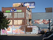
Sonic Unyon Recording Company, is a Hamilton, Ontario
Hamilton, Ontario
Hamilton is a port city in the Canadian province of Ontario. Conceived by George Hamilton when he purchased the Durand farm shortly after the War of 1812, Hamilton has become the centre of a densely populated and industrialized region at the west end of Lake Ontario known as the Golden Horseshoe...
-based record label
Record label
In the music industry, a record label is a brand and a trademark associated with the marketing of music recordings and music videos. Most commonly, a record label is the company that manages such brands and trademarks, coordinates the production, manufacture, distribution, marketing and promotion,...
, (Wilson Street near James Street North
James Street (Hamilton, Ontario)
James Street is a Lower City arterial road in Hamilton, Ontario, Canada. It starts off at the base of the Niagara Escarpment from James Mountain Road, a mountain-access road in the city, originally was a one-way street going south throughout but now has sections of it that are two-way...
), that has put out releases by bands including Tristan Psionic
Tristan Psionic
Tristan Psionic was a Canadian indie rock band.Formed in the early 1990s in Hamilton, Ontario, the band consisted of vocalist Sandy McIntosh, guitarist Mark Milne, bassist Gary "Wool" McMaster and drummer Tim Potocic...
, Sianspheric
Sianspheric
SIANspheric , is a shoegaze/dream pop-oriented rock band from Hamilton, Ontario, Canada. They formed in 1994, and signed with the then-fledgling record label Sonic Unyon. The following year, Somnium, their debut album, was released...
, Shallow North Dakota
Shallow North Dakota
Shallow North Dakota is a three-piece noise rock/sludge metal band from Hamilton, Ontario. They have released several records on local label Sonic Unyon, and have toured with other notable Canadian acts such as Chore and Kittens...
, Eric's Trip
Eric's Trip
Eric's Trip is a Canadian indie rock band from Moncton, New Brunswick. Eric's Trip achieved prominence as the first Canadian band to be signed to Seattle's flagship grunge label Sub Pop in the early 1990s...
, Hayden
Hayden (musician)
Paul Hayden Desser who records as Hayden, is a Canadian singer-songwriter from Thornhill, Ontario.His early works are a largely eclectic mix of genres from grunge rock to alt country, as demonstrated by his first full album, Everything I Long For, released in 1995. Since then his work has become...
, the New Grand
The New Grand
The New Grand is a Canadian indie rock band from London, Ontario, Canada. Known for their explosive live shows, they released two full-length albums on Sonic Unyon Records....
, Frank Black and the Catholics, A Northern Chorus
A Northern Chorus
A Northern Chorus was a Canadian band from Hamilton, Ontario.-History:The band was formed in 1999 after the breakup of Stu Livingstone and Pete Hall's previous band, Datura Dream Defered. They have released four records on the Sonic Unyon label, Before We All Go To Pieces, Spirit Flags, Bitter...
and Raising the Fawn
Raising the Fawn
Raising the Fawn is a Canadian indie rock band, with its roots in Toronto. The band is composed of John Crossingham , Scott Remila and Dylan Green...
. Founded in 1992 by Mark Milne, Sandy McIntosh and Tim Potocic (of Tristan Psionic
Tristan Psionic
Tristan Psionic was a Canadian indie rock band.Formed in the early 1990s in Hamilton, Ontario, the band consisted of vocalist Sandy McIntosh, guitarist Mark Milne, bassist Gary "Wool" McMaster and drummer Tim Potocic...
), Sonic Unyon is one of the largest independent labels in Canada.
Time capsule
A Time capsuleTime capsule
A time capsule is an historic cache of goods or information, usually intended as a method of communication with future people and to help future archaeologists, anthropologists, or historians...
was buried beneath a marker on the north-east corner of James & Wilson Streets on Wednesday November 16, 1988 by the Jamesville Business Community under the aegis of the City's Business Improvement Area (B.I.A.) Programme. It commemorates the completion of the James Street North streetscape project (1986–1988) which marked the renaissance of this historic link between the Hamilton Harbour and the City Centre.
James Street has always been the focal point for new Canadians arriving in Hamilton, first by ship from overseas docking at the foot of James Street later by train at the CN
Canadian National Railway
The Canadian National Railway Company is a Canadian Class I railway headquartered in Montreal, Quebec. CN's slogan is "North America's Railroad"....
Railway Station. The first arrivals were English, Scottish and Irish; later came Italian
Italian people
The Italian people are an ethnic group that share a common Italian culture, ancestry and speak the Italian language as a mother tongue. Within Italy, Italians are defined by citizenship, regardless of ancestry or country of residence , and are distinguished from people...
and German; more recently Portuguese
Portuguese people
The Portuguese are a nation and ethnic group native to the country of Portugal, in the west of the Iberian peninsula of south-west Europe. Their language is Portuguese, and Roman Catholicism is the predominant religion....
and then Greek. All in their turn have added to the cultural richness of the street. The Capsule is to be opened on Tuesday, November 16, 2038 by the Mayor, Alderman and Business Leaders of James Street North on that day.
Those that were in attendance in 1988 when the time capsule was buried include Bob Morrow
Bob Morrow
Robert Maxwell Morrow UE is a Canadian politician, who served as mayor of Hamilton, Ontario from 1982 to 2000. He was the longest-serving mayor in the city's history....
(Mayor), Sidney H. Leon (President of the Jamesville B.I.A.), Jerry Sherman (Vice President of Jamesville B.I.A.), Vince Agro
Vince Agro
Vince Agro was acting mayor of Hamilton, Ontario from 1976 to 1977. He assumed the position after Victor Copps had a heart attack. He ran for a full term as mayor in 1976, but was defeated by fellow alderman Jack MacDonald. He served as alderman for Ward Two from 1970 until 1976, and again from...
(Alderman Ward 2), Filipe M. Vianna (Treasurer) and William M. McCulloch (Alderman Ward 2).
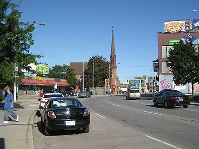
Landmarks

- Hamilton City Centre (Mall, formerly the Eaton's Centre), this point marks the end of York BoulevardYork Boulevard (Hamilton, Ontario)York Boulevard is a Lower City arterial road in Hamilton, Ontario, Canada. Formerly known as Highway 2 and Highway 6,starts off in Burlington, Ontario at Plains Road West as a two-way arterial road that wraps around and over the Hamilton Harbour and enters the city of Hamilton in the West-end past...
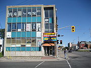
and the same road then becomes Wilson Street - Jamesville, which is shared by the Italian & Portuguese communities of Hamilton
- James North Art District
- Time capsuleTime capsuleA time capsule is an historic cache of goods or information, usually intended as a method of communication with future people and to help future archaeologists, anthropologists, or historians...
, north-east corner of James & Wilson Streets (Nov-16-1988, Nov-16-2038) - Sonic Unyon Recording CompanySonic UnyonSonic Unyon Recording Company is an independent record label based in Hamilton, Ontario, Canada. The retail store is located on Wilson Street near James Street North)...
- Living Rock Ministries building
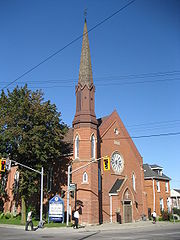
- Stewart Memorial Church (originally St. Paul's African Methodist Episcopal Church. 1961 also became a Masonic Hall. North of Wilson on John Street.)
- St. John's Evangelical Lutheran Church
- Hamilton Downtown Mosque
- Beasley ParkBeasley Park (Hamilton, Ontario)Beasley Park is a park in the Lower City of Hamilton, Ontario, Canada and named after Richard Beasley, , a soldier, political figure, farmer and businessman in Upper Canada. Richard Beasley was one of Hamilton's first settlers who came to Canada from New York in 1777...
- Beasley Park water fountain
- Beasley Park Community Centre
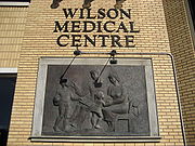
- Wilson Medical Centre/ Pharmacy
- Wilson Diagnostic Centre
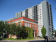
- Dr. J. Edgar Davey Elementary School
- Wellington Place Apartments, 18-storey building
- Jack C. Beemer Park
- Eagle Worldwide Revival Centre, (church)
- Cathedral Secondary SchoolCathedral Secondary SchoolCathedral Secondary School is a Roman Catholic high school situated in Suva, the capital of Fiji. The school was founded in 1961....
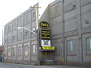
- Parks Furniture Warehouse building
Communities
Note: Listing of neighbourhoods from West to East.- Central – The financial center of Hamilton, OntarioHamilton, OntarioHamilton is a port city in the Canadian province of Ontario. Conceived by George Hamilton when he purchased the Durand farm shortly after the War of 1812, Hamilton has become the centre of a densely populated and industrialized region at the west end of Lake Ontario known as the Golden Horseshoe...
- Beasley
- Landsdale
- Gibson
- Stipeley
Roads that are parallel with Wilson Street
- Burlington StreetBurlington StreetBurlington Street is a road in Hamilton, Ontario, stretching along the south shore of Hamilton Harbour in Lake Ontario. Burlington Street has four different statuses along the route. In its western terminus, it is a collector route ending at Bay Street North...
, West/East - Barton StreetBarton Street (Hamilton, Ontario)Barton Street is an arterial road in the Lower City of Hamilton, Ontario, Canada. It's also the longest street in the city. It starts off at the Western end of town at Locke Street North and is a two-way street that stretches eastward through a number of different and varied communities in the...
, West/East - Cannon StreetCannon Street (Hamilton, Ontario)Cannon Street, is a Lower City collector road in Hamilton, Ontario, Canada. It starts off at Queen Street North as a one-way street up to Sherman Avenue North where it then switches over to a two-way street the rest of the way Eastward and ends just past Kenilworth Avenue North on Barons Avenue...
, West/East - Wilson Street
- King William StreetKing William Street (Hamilton, Ontario)400px|thumb|Theatre AquariusKing William Street is a Lower City collector road in Hamilton, Ontario, Canada. It starts off at the western-end at James Street North and is a one-way street until Mary Street, where it becomes a two-way street that ends at Wentworth Street North.-History:In 1922,...
- King Street, West/East
- Main StreetMain Street (Hamilton, Ontario)Main Street, is a Lower City arterial road in Hamilton, Ontario, Canada. It starts east of Wilson Street in Ancaster at White Chapel Cemetery as a two-way street and switches over to a one-way street at Paradise Road South, in Westdale, where it continues up to the Delta where it once again...
, West/East; – Queenston RoadQueenston Road (Hamilton, Ontario)Queenston Road is a two-way Lower City arterial road in Hamilton, Ontario, Canada. Also known as Highway 8. It starts off at the Queenston Traffic Circle and travels eastward over the Red Hill Valley Parkway and into Stoney Creek past the Fruitland and Winona communities and into Niagara Region as... - Jackson StreetJackson Street (Hamilton, Ontario)Jackson Street, is a Lower City collector road in Hamilton, Ontario, Canada. It starts off West of Locke Street South at Jackson Playground as a one-way street up to Queen Street South where it then switches over to a two-way street and is interrupted at Bay Street South the site of the Hamilton...
, East - Hunter StreetHunter Street (Hamilton, Ontario)Hunter Street is a Lower City collector road in Hamilton, Ontario, Canada. It is a one-way street that starts West of Locke Street at Hill Street Park and ends two blocks East of Victoria Avenue at Emerald Street...
, West/East - Augusta StreetAugusta Street (Hamilton, Ontario)Augusta Street is a Lower City collector road in Hamilton, Ontario, Canada. A two-way collector road that starts off on James Street South and ends 4-blocks East at Shamrock Park just past Walnut Street South.-History:thumb|Augusta Street, landmark...
- Charlton AvenueCharlton Avenue (Hamilton, Ontario)Charlton Avenue, is a Lower City collector road in Hamilton, Ontario, Canada. This collector road starts of just West of Dundurn Street as a one-way street up to James Street South where it then switches over to a two-way street the rest of the way eastward and ends at Wentworth Street South right...
, West/East - Aberdeen AvenueAberdeen Avenue (Hamilton, Ontario)Aberdeen Avenue is a Lower City arterial road in Hamilton, Ontario, Canada. It starts off just West of Longwood Road South and East of Highway 403 as a two-way thoroughfare up to Queen Street South where it then switches over to a one-way collector road to Bay Street South and then to another...
Niagara Escarpment (Mountain) Roads:
- Concession StreetConcession Street (Hamilton, Ontario)Concession Street is an Upper City arterial road in Hamilton, Ontario, Canada. It starts at Belvidere Avenue, just West of Sam Lawrence Park, and extends eastward past Mountain Drive Park on Upper Gage Avenue and ends shortly thereafter at East 43rd Street.Note: East of East 43rd Street the road...
- Queensdale Avenue West/ East
- Scenic Drive – Fennell AvenueFennell Avenue (Hamilton, Ontario)Fennell Avenue, is an Upper City arterial road in Hamilton, Ontario, Canada. It starts of just West Garth Street on the West mountain and is a two-way street throughout that extends eastward and ends at Mountain Brow Boulevard, a road that wraps around the edge of the Niagara Escarpment on...
, West/East - Sanatorium Road
- Mohawk RoadMohawk Road (Hamilton, Ontario)Mohawk Road, is an Upper City arterial road in Hamilton, Ontario, Canada. It is a two-way street throughout that starts just West of Highway 403 & Meadowlands and travels eastward linking up with the Lincoln M. Alexander Parkway. Mohawk Road east of Highway 403 resumes again in front of Iroquoia...
, West/East - Limeridge RoadLimeridge Road (Hamilton, Ontario)Limeridge Road is a two-way Upper City collector road in Hamilton, Ontario, Canada. It starts off just West of Garth Street/William McCulloch Park as Limeridge Court and cuts across the Hamilton mountain eastward running parallel with the Lincoln M...
West/East - Lincoln M. Alexander ParkwayLincoln M. Alexander ParkwayThe Lincoln Alexander Parkway, officially nicknamed "The Linc", is a municipal expressway in the Canadian city of Hamilton, Ontario. Located on the Hamilton mountain, atop the Niagara Escarpment...
– Mud Street, (Hamilton City Road 11) - Stone Church RoadStone Church Road (Hamilton, Ontario)Stone Church Road, is a two-way Upper City east-west arterial road in Hamilton, Ontario, Canada. It starts at Golf Links Road, just east of Meadowlands, and goes across the Escarpment and ends at Upper Mount Albion Road....
, West/East  ; Rymal Road, West/East
- Twenty Road
Roads that cross Wilson Street
Note: Listing of streets from West to East.- James StreetJames Street (Hamilton, Ontario)James Street is a Lower City arterial road in Hamilton, Ontario, Canada. It starts off at the base of the Niagara Escarpment from James Mountain Road, a mountain-access road in the city, originally was a one-way street going south throughout but now has sections of it that are two-way...
, North - Hughson StreetHughson Street (Hamilton, Ontario)Hughson Street is a Lower City collector road in Hamilton, Ontario, Canada. It starts at Charlton Avenue East at St. Joseph's hospital and runs north to Haymarket Street in the downtown where it's cut off by the Hamilton GO Transit station. Up to this point it is a two-way street...
, North - John StreetJohn Street (Hamilton, Ontario)John Street, is a Lower City arterial road in Hamilton, Ontario, Canada. Originally it was known as Mountain Road or Ancaster Road. It starts off at the base of Arkledun Avenue, a Mountain-access road in the city, just east of St.Joseph's Hospital where it's a one-way street going north and tunnels...
, North - Catharine StreetCatharine Street (Hamilton, Ontario)Catharine Street, is a Lower City collector road in Hamilton, Ontario, Canada. It starts off at Charlton Avenue East at Woolverton Park in the Corktown neighbourhood as a one-way street , tunnels underneath the Hunter Street Railway bridge and stretches up to Barton Street East where it then turns...
, North - Ferguson AvenueFerguson Avenue (Hamilton, Ontario)Ferguson Avenue, is a Lower City collector road in Hamilton, Ontario, Canada. Is a two-way street throughout that starts off at the base of the Mountain on Foster Street. It's interrupted 3-blocks north at Corktown Park where Canadian Pacific Railway lines passes through it...
, North - Wellington StreetWellington Street (Hamilton, Ontario)Wellington Street, is a Lower City arterial road in Hamilton, Ontario, Canada. It starts off at Charlton Avenue East as a two-way street for only one block where it's then blocked off by the Corktown Park and a couple of Canadian National Railway lines that cut through it...
, North - Victoria AvenueVictoria Avenue (Hamilton, Ontario)Victoria Avenue, is a Lower City arterial road in Hamilton, Ontario, Canada. It starts off as a ramp and part of a Mountain-access road, the Claremont Access, on Hunter Street East in the Stinson neighbourhood...
, North - Wentworth StreetWentworth Street (Hamilton, Ontario)Wentworth Street, is a Lower City arterial road in Hamilton, Ontario, Canada. It starts off at the base of the Niagara Escarpment on Charlton Avenue East just before the CP lines as a two-way street for 2-blocks up past Cumberland Avenue up to Rutherford Avenue where it then switches over to a...
, North - Sherman AvenueSherman Avenue (Hamilton, Ontario)Sherman Avenue, is a Lower City collector road in Hamilton, Ontario, Canada. It starts off at the base of the Niagara Escarpment just south of Cumberland Avenue and is a one-way street northbound that cuts through the city's North End industrial neighbourhood and ends at Ship Street, the site of...
, North