
.gif)
Augusta Street (Hamilton, Ontario)
Encyclopedia
Augusta Street is a Lower City collector road in Hamilton, Ontario
, Canada
. A two-way collector road that starts off on James Street South
and ends 4-blocks East at Shamrock Park just past Walnut Street South.
 Augusta Street originally between Catharine Street
and Ferguson Avenue
was known as O'Reilly Street. In 1895 when the TH&B (Toronto, Hamilton and Buffalo Railway
) line was built the street was trancated at Walnut Street South. The railway line also cut the Corktown neighbourhood in two. The elevated railway line cuts through Shamrock Park.
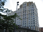
Chateau Royale is a multi-story residential condominium
located in downtown Hamilton, Ontario
, Canada
on James Street South
near Augusta Street. Standing at 14-stories (70.0 metres) it is the 19th tallest building in the city. It opened in 2006 after being transformed from an office tower complex into a condominium complex. Originally the office tower complex was known as the Undermount Office Complex and before the Office Complex this was the site of The Alexandra, a roller rink which opened on Christmas Day 1906. It became a popular entertainment spot that featured skating, dancing and big band music. The roller rink
closed down 30 April, 1964 and was torn down soon thereafter.
Niagara Escarpment (Mountain) Roads:
Hamilton, Ontario
Hamilton is a port city in the Canadian province of Ontario. Conceived by George Hamilton when he purchased the Durand farm shortly after the War of 1812, Hamilton has become the centre of a densely populated and industrialized region at the west end of Lake Ontario known as the Golden Horseshoe...
, Canada
Canada
Canada is a North American country consisting of ten provinces and three territories. Located in the northern part of the continent, it extends from the Atlantic Ocean in the east to the Pacific Ocean in the west, and northward into the Arctic Ocean...
. A two-way collector road that starts off on James Street South
James Street (Hamilton, Ontario)
James Street is a Lower City arterial road in Hamilton, Ontario, Canada. It starts off at the base of the Niagara Escarpment from James Mountain Road, a mountain-access road in the city, originally was a one-way street going south throughout but now has sections of it that are two-way...
and ends 4-blocks East at Shamrock Park just past Walnut Street South.
History
Catharine Street (Hamilton, Ontario)
Catharine Street, is a Lower City collector road in Hamilton, Ontario, Canada. It starts off at Charlton Avenue East at Woolverton Park in the Corktown neighbourhood as a one-way street , tunnels underneath the Hunter Street Railway bridge and stretches up to Barton Street East where it then turns...
and Ferguson Avenue
Ferguson Avenue (Hamilton, Ontario)
Ferguson Avenue, is a Lower City collector road in Hamilton, Ontario, Canada. Is a two-way street throughout that starts off at the base of the Mountain on Foster Street. It's interrupted 3-blocks north at Corktown Park where Canadian Pacific Railway lines passes through it...
was known as O'Reilly Street. In 1895 when the TH&B (Toronto, Hamilton and Buffalo Railway
Toronto, Hamilton and Buffalo Railway
The Toronto, Hamilton and Buffalo Railway was a railway based in Hamilton that ran in Southern Ontario from 1894 to 1987. It never reached the other two cities in its name, although it did have branch lines extending to Dunnville and Port Maitland.-History:...
) line was built the street was trancated at Walnut Street South. The railway line also cut the Corktown neighbourhood in two. The elevated railway line cuts through Shamrock Park.
Chateau Royale is a multi-story residential condominium
Condominium
A condominium, or condo, is the form of housing tenure and other real property where a specified part of a piece of real estate is individually owned while use of and access to common facilities in the piece such as hallways, heating system, elevators, exterior areas is executed under legal rights...
located in downtown Hamilton, Ontario
Hamilton, Ontario
Hamilton is a port city in the Canadian province of Ontario. Conceived by George Hamilton when he purchased the Durand farm shortly after the War of 1812, Hamilton has become the centre of a densely populated and industrialized region at the west end of Lake Ontario known as the Golden Horseshoe...
, Canada
Canada
Canada is a North American country consisting of ten provinces and three territories. Located in the northern part of the continent, it extends from the Atlantic Ocean in the east to the Pacific Ocean in the west, and northward into the Arctic Ocean...
on James Street South
James Street (Hamilton, Ontario)
James Street is a Lower City arterial road in Hamilton, Ontario, Canada. It starts off at the base of the Niagara Escarpment from James Mountain Road, a mountain-access road in the city, originally was a one-way street going south throughout but now has sections of it that are two-way...
near Augusta Street. Standing at 14-stories (70.0 metres) it is the 19th tallest building in the city. It opened in 2006 after being transformed from an office tower complex into a condominium complex. Originally the office tower complex was known as the Undermount Office Complex and before the Office Complex this was the site of The Alexandra, a roller rink which opened on Christmas Day 1906. It became a popular entertainment spot that featured skating, dancing and big band music. The roller rink
Roller rink
A roller rink is a hard surface used for roller skating or inline skating. This includes roller hockey, speed skating, and recreational skating...
closed down 30 April, 1964 and was torn down soon thereafter.
Landmarks
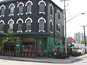
Note: Listing of Landmarks from West to East.- James Street South Shopping District
- Chateau Royale (condominium), just north of Augusta on James Street SouthJames Street (Hamilton, Ontario)James Street is a Lower City arterial road in Hamilton, Ontario, Canada. It starts off at the base of the Niagara Escarpment from James Mountain Road, a mountain-access road in the city, originally was a one-way street going south throughout but now has sections of it that are two-way...
- Augusta British Pub District:
- The Pheasant Plucker
- Aout'n About Inc.
- Augusta's 'Winking Judge'
- Cat 'N' Fiddle
- Gallagher's
- The Ship
- Augusta House Gastropub
- Residences on Augusta (Seniors residence)
- Canadian Pacific RailwayCanadian Pacific RailwayThe Canadian Pacific Railway , formerly also known as CP Rail between 1968 and 1996, is a historic Canadian Class I railway founded in 1881 and now operated by Canadian Pacific Railway Limited, which began operations as legal owner in a corporate restructuring in 2001...
line (originally the TH&B, Toronto, Hamilton and Buffalo RailwayToronto, Hamilton and Buffalo RailwayThe Toronto, Hamilton and Buffalo Railway was a railway based in Hamilton that ran in Southern Ontario from 1894 to 1987. It never reached the other two cities in its name, although it did have branch lines extending to Dunnville and Port Maitland.-History:...
line (1892-1987)) - Shamrock Park
- Blueline Taxi Cab company (Just north of Augusta on John StreetJohn Street (Hamilton, Ontario)John Street, is a Lower City arterial road in Hamilton, Ontario, Canada. Originally it was known as Mountain Road or Ancaster Road. It starts off at the base of Arkledun Avenue, a Mountain-access road in the city, just east of St.Joseph's Hospital where it's a one-way street going north and tunnels...
)
Roads that are parallel with Augusta Street
Lower City Roads:- Burlington StreetBurlington StreetBurlington Street is a road in Hamilton, Ontario, stretching along the south shore of Hamilton Harbour in Lake Ontario. Burlington Street has four different statuses along the route. In its western terminus, it is a collector route ending at Bay Street North...
, West/East - Barton StreetBarton Street (Hamilton, Ontario)Barton Street is an arterial road in the Lower City of Hamilton, Ontario, Canada. It's also the longest street in the city. It starts off at the Western end of town at Locke Street North and is a two-way street that stretches eastward through a number of different and varied communities in the...
, West/East - Cannon StreetCannon Street (Hamilton, Ontario)Cannon Street, is a Lower City collector road in Hamilton, Ontario, Canada. It starts off at Queen Street North as a one-way street up to Sherman Avenue North where it then switches over to a two-way street the rest of the way Eastward and ends just past Kenilworth Avenue North on Barons Avenue...
, West/East - Wilson StreetWilson Street (Hamilton, Ontario)Wilson Street is a Lower City collector road in Hamilton, Ontario, Canada. It starts off at James Street North and works its way East and ends at Sherman Avenue North...
- King William StreetKing William Street (Hamilton, Ontario)400px|thumb|Theatre AquariusKing William Street is a Lower City collector road in Hamilton, Ontario, Canada. It starts off at the western-end at James Street North and is a one-way street until Mary Street, where it becomes a two-way street that ends at Wentworth Street North.-History:In 1922,...
- King Street, West/East
- Main StreetMain Street (Hamilton, Ontario)Main Street, is a Lower City arterial road in Hamilton, Ontario, Canada. It starts east of Wilson Street in Ancaster at White Chapel Cemetery as a two-way street and switches over to a one-way street at Paradise Road South, in Westdale, where it continues up to the Delta where it once again...
, West/East; - Queenston RoadQueenston Road (Hamilton, Ontario)Queenston Road is a two-way Lower City arterial road in Hamilton, Ontario, Canada. Also known as Highway 8. It starts off at the Queenston Traffic Circle and travels eastward over the Red Hill Valley Parkway and into Stoney Creek past the Fruitland and Winona communities and into Niagara Region as... - Jackson StreetJackson Street (Hamilton, Ontario)Jackson Street, is a Lower City collector road in Hamilton, Ontario, Canada. It starts off West of Locke Street South at Jackson Playground as a one-way street up to Queen Street South where it then switches over to a two-way street and is interrupted at Bay Street South the site of the Hamilton...
, West/East - Hunter StreetHunter Street (Hamilton, Ontario)Hunter Street is a Lower City collector road in Hamilton, Ontario, Canada. It is a one-way street that starts West of Locke Street at Hill Street Park and ends two blocks East of Victoria Avenue at Emerald Street...
, West/East - Augusta Street
- Charlton AvenueCharlton Avenue (Hamilton, Ontario)Charlton Avenue, is a Lower City collector road in Hamilton, Ontario, Canada. This collector road starts of just West of Dundurn Street as a one-way street up to James Street South where it then switches over to a two-way street the rest of the way eastward and ends at Wentworth Street South right...
, West/East - Aberdeen AvenueAberdeen Avenue (Hamilton, Ontario)Aberdeen Avenue is a Lower City arterial road in Hamilton, Ontario, Canada. It starts off just West of Longwood Road South and East of Highway 403 as a two-way thoroughfare up to Queen Street South where it then switches over to a one-way collector road to Bay Street South and then to another...
Niagara Escarpment (Mountain) Roads:
- Concession StreetConcession Street (Hamilton, Ontario)Concession Street is an Upper City arterial road in Hamilton, Ontario, Canada. It starts at Belvidere Avenue, just West of Sam Lawrence Park, and extends eastward past Mountain Drive Park on Upper Gage Avenue and ends shortly thereafter at East 43rd Street.Note: East of East 43rd Street the road...
- Queensdale Avenue West/ East
- Scenic Drive - Fennell AvenueFennell Avenue (Hamilton, Ontario)Fennell Avenue, is an Upper City arterial road in Hamilton, Ontario, Canada. It starts of just West Garth Street on the West mountain and is a two-way street throughout that extends eastward and ends at Mountain Brow Boulevard, a road that wraps around the edge of the Niagara Escarpment on...
, West/East - Sanatorium Road
- Mohawk RoadMohawk Road (Hamilton, Ontario)Mohawk Road, is an Upper City arterial road in Hamilton, Ontario, Canada. It is a two-way street throughout that starts just West of Highway 403 & Meadowlands and travels eastward linking up with the Lincoln M. Alexander Parkway. Mohawk Road east of Highway 403 resumes again in front of Iroquoia...
, West/East - Limeridge RoadLimeridge Road (Hamilton, Ontario)Limeridge Road is a two-way Upper City collector road in Hamilton, Ontario, Canada. It starts off just West of Garth Street/William McCulloch Park as Limeridge Court and cuts across the Hamilton mountain eastward running parallel with the Lincoln M...
West/East - Lincoln M. Alexander ParkwayLincoln M. Alexander ParkwayThe Lincoln Alexander Parkway, officially nicknamed "The Linc", is a municipal expressway in the Canadian city of Hamilton, Ontario. Located on the Hamilton mountain, atop the Niagara Escarpment...
- Mud Street, (Hamilton City Road 11) - Stone Church RoadStone Church Road (Hamilton, Ontario)Stone Church Road, is a two-way Upper City east-west arterial road in Hamilton, Ontario, Canada. It starts at Golf Links Road, just east of Meadowlands, and goes across the Escarpment and ends at Upper Mount Albion Road....
, West/East  ; Rymal Road, West/East
- Twenty Road
Roads that cross Augusta Street
Note: Listing of streets from West to East.- James StreetJames Street (Hamilton, Ontario)James Street is a Lower City arterial road in Hamilton, Ontario, Canada. It starts off at the base of the Niagara Escarpment from James Mountain Road, a mountain-access road in the city, originally was a one-way street going south throughout but now has sections of it that are two-way...
, South - Hughson StreetHughson Street (Hamilton, Ontario)Hughson Street is a Lower City collector road in Hamilton, Ontario, Canada. It starts at Charlton Avenue East at St. Joseph's hospital and runs north to Haymarket Street in the downtown where it's cut off by the Hamilton GO Transit station. Up to this point it is a two-way street...
, South - John StreetJohn Street (Hamilton, Ontario)John Street, is a Lower City arterial road in Hamilton, Ontario, Canada. Originally it was known as Mountain Road or Ancaster Road. It starts off at the base of Arkledun Avenue, a Mountain-access road in the city, just east of St.Joseph's Hospital where it's a one-way street going north and tunnels...
, South - Catharine StreetCatharine Street (Hamilton, Ontario)Catharine Street, is a Lower City collector road in Hamilton, Ontario, Canada. It starts off at Charlton Avenue East at Woolverton Park in the Corktown neighbourhood as a one-way street , tunnels underneath the Hunter Street Railway bridge and stretches up to Barton Street East where it then turns...
, South