

Concession Street (Hamilton, Ontario)
Encyclopedia
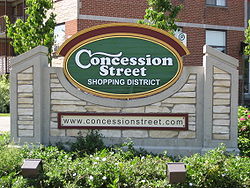
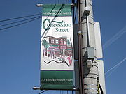
Concession Street is an Upper City (mountain) arterial road in Hamilton, Ontario
Hamilton, Ontario
Hamilton is a port city in the Canadian province of Ontario. Conceived by George Hamilton when he purchased the Durand farm shortly after the War of 1812, Hamilton has become the centre of a densely populated and industrialized region at the west end of Lake Ontario known as the Golden Horseshoe...
, Canada
Canada
Canada is a North American country consisting of ten provinces and three territories. Located in the northern part of the continent, it extends from the Atlantic Ocean in the east to the Pacific Ocean in the west, and northward into the Arctic Ocean...
. It starts at Belvidere Avenue, just West of Sam Lawrence Park, and extends eastward past Mountain Drive Park on Upper Gage Avenue
Upper Gage Avenue (Hamilton, Ontario)
Upper Gage Avenue is an Upper City arterial road in Hamilton, Ontario, Canada. It starts off at Concession Street in front of Mountain Drive Park and works its way southward and ends just past Rymal Road beside Broughton West Park 2...
and ends shortly thereafter at East 43rd Street.
Note: East of East 43rd Street the road is known as Mountain Brow Boulevard.
History

Hamilton, Ontario
Hamilton is a port city in the Canadian province of Ontario. Conceived by George Hamilton when he purchased the Durand farm shortly after the War of 1812, Hamilton has become the centre of a densely populated and industrialized region at the west end of Lake Ontario known as the Golden Horseshoe...
and known as "Mount Hamilton" but by 1891, properties north of Concession Street were annexed by the city of Hamilton and were serviced with water, sewers and sidewalks. Note: Aberdeen Avenue in the Lower City was originally known as Concession Street.
Concession Street, is the oldest settlement area on the Hamilton mountain
Hamilton Mountain
Hamilton Mountain is a federal electoral district in Ontario, Canada, that has been represented in the Canadian House of Commons since 1968. The riding is located in the Hamilton, Ontario region....
. It was once an African American neighbourhood settled by slaves escaping the U.S. via the underground railroad
Underground Railroad
The Underground Railroad was an informal network of secret routes and safe houses used by 19th-century black slaves in the United States to escape to free states and Canada with the aid of abolitionists and allies who were sympathetic to their cause. The term is also applied to the abolitionists,...
Underground Railroad
Underground Railroad
The Underground Railroad was an informal network of secret routes and safe houses used by 19th-century black slaves in the United States to escape to free states and Canada with the aid of abolitionists and allies who were sympathetic to their cause. The term is also applied to the abolitionists,...
. This part of Hamilton Mountain was then known as, "Little Africa". Canada in general and Hamilton in particular received these refugees with great sympathy and understanding. They were illiterate and took up education in the "Mission", a union church and school building, erected in 1860. The Union Mission was situated on the south-side of Concession between Twenty-Second and Twenty Third Streets. The adults would sit in with the children and spell out words and hoped that they might some day be able to read the Bible
Bible
The Bible refers to any one of the collections of the primary religious texts of Judaism and Christianity. There is no common version of the Bible, as the individual books , their contents and their order vary among denominations...
. They also liked to display pictures of Queen Victoria alongside that of Abraham Lincoln
Abraham Lincoln
Abraham Lincoln was the 16th President of the United States, serving from March 1861 until his assassination in April 1865. He successfully led his country through a great constitutional, military and moral crisis – the American Civil War – preserving the Union, while ending slavery, and...
. They also took on new surnames to avoid being identified and recaptured. Many of the families there favoured the name "Johnson" as well as "Atkins", "Murdoch" and "Green". Over the years these families abandoned the homes they had established, to be seen no more on the hilltop. They didn't like the long cold winters and eventually returned to the United States
United States
The United States of America is a federal constitutional republic comprising fifty states and a federal district...
. Today it is a predominantly white neighbourhood.
During the 19th century it did not occur to inhabitants of Hamilton that the mountain top would become thickly populated. Concession Street had been a deer run, then a cow path, at last evolved into a stoned road and had a toll-gate placed on it. All other roads on the mountain were left in a state of nature, where wagons sank to the hubs in the sticky mud for which Barton Township was famous.
From the year 1910, (interrupted by the outbreak of World War I
World War I
World War I , which was predominantly called the World War or the Great War from its occurrence until 1939, and the First World War or World War I thereafter, was a major war centred in Europe that began on 28 July 1914 and lasted until 11 November 1918...
in 1914), a great building boom was enjoyed on the mountain area, when many farms were cut into lots and many streets opened. Immigration flowed and the newcomers were chiefly from the British Isles
British Isles
The British Isles are a group of islands off the northwest coast of continental Europe that include the islands of Great Britain and Ireland and over six thousand smaller isles. There are two sovereign states located on the islands: the United Kingdom of Great Britain and Northern Ireland and...
. They were industrious workingmen who soon built comfortable homes for themselves. When the city water came to the mountain, followed by sewers
Sanitary sewer
A sanitary sewer is a separate underground carriage system specifically for transporting sewage from houses and commercial buildings to treatment or disposal. Sanitary sewers serving industrial areas also carry industrial wastewater...
, there was no restraint on the building program. Since then the growth has been phenomenal.
In 1949 Mayor Sam Lawrence went on record as favouring a separate mountain ward. The city's focus was now to grow south with the eastern boundary, at the time, now established at Red Hill Creek.
Transportation infrastructure
The Jolley Cut, (named after James JolleyJames Jolley
James Jolley, was born in 1813 in Argyllshire, Scotland, and died on 28 November 1892 in Hamilton, Ontario. He is buried in Hamilton Cemetery. Jolley was a saddler, harnessmaker, and politician. He funded construction of the Jolley Cut, a Mountain access road in Hamilton, Ontario...
, (1813–1892), saddler, harnessmaker, politician) is a mountain/lower city-access road in Hamilton. James Jolley funded construction of the Jolley Cut.
It was not unusual for the mountain settler in those days to undertake the construction
Construction
In the fields of architecture and civil engineering, construction is a process that consists of the building or assembling of infrastructure. Far from being a single activity, large scale construction is a feat of human multitasking...
of a road
Road
A road is a thoroughfare, route, or way on land between two places, which typically has been paved or otherwise improved to allow travel by some conveyance, including a horse, cart, or motor vehicle. Roads consist of one, or sometimes two, roadways each with one or more lanes and also any...
down the face of the escarpment, known as a short-cut, which might be used only by the family who constructed it or might open to the public. At the west end they had the Fillman Mountain, the Horning Mountain and later Beckett's Drive — all done by hand labour. Eventually both Fillman & Horning Mountains fell to disuse because they were dangerously too steep
Slope
In mathematics, the slope or gradient of a line describes its steepness, incline, or grade. A higher slope value indicates a steeper incline....
.
One time the city even considered adding a streetcar route on the mountain like they had done with the lower city. (Note: When street railway lines were at its peak in Hamilton there was a total of 27.97 miles of railway lines employed by the HSR
HSR
The abbreviation HSR may stand for:*High school reunion* High-speed rail* Haliburton Scout Reserve, a Scouts Canada camp located near Haliburton, Ontario* Hamilton Street Railway* Hart-Scott-Rodino Antitrust Improvements Act* Health Services Research...
.) In 1913, promoters of the Civic Improvement Society, composed of mountain townshipmen, stated that, 'if a street railway were run on the mountain then the area would grow rapidly.' They never got their wish. They also stated at the time that 'the mountain was lacking adequate garbage collection, water supply and a sewage system'. Electric street lighting was another issue of the day as the only lighting they were getting were from city lights coming in from lower city Hamilton.
In 1924 the city of Hamilton agreed to add more street lights to the mountain in an area bounded by Fennell Avenue
Fennell Avenue (Hamilton, Ontario)
Fennell Avenue, is an Upper City arterial road in Hamilton, Ontario, Canada. It starts of just West Garth Street on the West mountain and is a two-way street throughout that extends eastward and ends at Mountain Brow Boulevard, a road that wraps around the edge of the Niagara Escarpment on...
(south), the escarpment
Niagara Escarpment
The Niagara Escarpment is a long escarpment, or cuesta, in the United States and Canada that runs westward from New York State, through Ontario, Michigan, Wisconsin and Illinois...
(north), Ontario Hospital on West 5th Street
West 5th Street (Hamilton, Ontario)
West 5th Street is an Upper City arterial road in Hamilton, Ontario, Canada. It starts off in the north at James Mountain Road, a mountain-access road, and extends southward past Rymal Road where it ends just south of Christopher Drive...
(west) and Upper Gage Avenue
Upper Gage Avenue (Hamilton, Ontario)
Upper Gage Avenue is an Upper City arterial road in Hamilton, Ontario, Canada. It starts off at Concession Street in front of Mountain Drive Park and works its way southward and ends just past Rymal Road beside Broughton West Park 2...
(east). Street lights on every second pole.
In 1927 the HSR
HSR
The abbreviation HSR may stand for:*High school reunion* High-speed rail* Haliburton Scout Reserve, a Scouts Canada camp located near Haliburton, Ontario* Hamilton Street Railway* Hart-Scott-Rodino Antitrust Improvements Act* Health Services Research...
seriously considered adding a bus route on the Hamilton Mountain and taking advantage of a proposed mountain road which would extend from James Street South
James Street (Hamilton, Ontario)
James Street is a Lower City arterial road in Hamilton, Ontario, Canada. It starts off at the base of the Niagara Escarpment from James Mountain Road, a mountain-access road in the city, originally was a one-way street going south throughout but now has sections of it that are two-way...
to a point 400 feet east of Ferguson Avenue
Ferguson Avenue (Hamilton, Ontario)
Ferguson Avenue, is a Lower City collector road in Hamilton, Ontario, Canada. Is a two-way street throughout that starts off at the base of the Mountain on Foster Street. It's interrupted 3-blocks north at Corktown Park where Canadian Pacific Railway lines passes through it...
. The road was being considered because the grade would be much smaller per cent than the Jolley Cut and cars would be able to negotiate the journey from the bottom to the top with less difficulty. Permission had to be obtained from the Department of Highways
Ministry of Transportation (Ontario)
The Ministry of Transportation of Ontario is the provincial ministry of the government of Ontario which is responsible for transport infrastructure and related law in Ontario. The ministry traces its roots back over a century to the 1890s, when the province began training Provincial Road Building...
if the Hamilton bus
Bus
A bus is a road vehicle designed to carry passengers. Buses can have a capacity as high as 300 passengers. The most common type of bus is the single-decker bus, with larger loads carried by double-decker buses and articulated buses, and smaller loads carried by midibuses and minibuses; coaches are...
es were to pass Concession Street. The city limits in 1927 only extended as far as the sidewalk on the southside of Concession, and all of the roadways past that point would come under jurisdiction of the provincial highways department, which at the time, did not encourage competition between two bus companies when one gave adequate service.
Incline railway
When the incline railways were running tourists did not consider it a trip to Hamilton complete until they had taken the jaunt to the top of one of these railways and looked down on the enchanting scene from an elevation of 285 feet. James StreetJames Street (Hamilton, Ontario)
James Street is a Lower City arterial road in Hamilton, Ontario, Canada. It starts off at the base of the Niagara Escarpment from James Mountain Road, a mountain-access road in the city, originally was a one-way street going south throughout but now has sections of it that are two-way...
, at the base of the Niagara Escarpment (mountain) was the site of the city's first Incline railway (1892–1932). Back then, the Incline railway on James Street was known as the Hamilton & Barton Incline Railway. The city's second Incline railway on Wentworth Street South
Wentworth Street (Hamilton, Ontario)
Wentworth Street, is a Lower City arterial road in Hamilton, Ontario, Canada. It starts off at the base of the Niagara Escarpment on Charlton Avenue East just before the CP lines as a two-way street for 2-blocks up past Cumberland Avenue up to Rutherford Avenue where it then switches over to a...
, (1895–1936), was known as the Eastend Incline Railway but was often called, The Mount Hamilton Incline Railway. The Eastend Incline on Wentworth Street was electrically operated and the Westend Incline on James Street depended on steam for its power.
In 1924, following the city's booming development in the east, there was some serious discussion regarding the addition of a third incline railway. The 2 locations be considered at the time were Sherman Avenue
Sherman Avenue (Hamilton, Ontario)
Sherman Avenue, is a Lower City collector road in Hamilton, Ontario, Canada. It starts off at the base of the Niagara Escarpment just south of Cumberland Avenue and is a one-way street northbound that cuts through the city's North End industrial neighbourhood and ends at Ship Street, the site of...
or Ottawa Street South
Ottawa Street (Hamilton, Ontario)
Ottawa street, is a Lower City arterial road in Hamilton, Ontario, Canada. It starts off at Lawrence Road at the base of the Niagara Escarpment and is a two-way street throughout cutting through the Delta and Crown Point neighbourhoods and the City's North End industrial neighbourhood...
. The population of Hamilton Mountain at the time was 6,000.
In 1929, the city's brochures were using the motto, "The City Beautiful and Hub of Canadian Highways" as well as "The City of Opportunity". In regards to the Incline railways, the brochures go on to boast, "There is no finer view anywhere on the North American continent than the panorama to be seen from the Hamilton mountain. The city below, the blue waters of Hamilton harbour and Lake Ontario
Lake Ontario
Lake Ontario is one of the five Great Lakes of North America. It is bounded on the north and southwest by the Canadian province of Ontario, and on the south by the American state of New York. Ontario, Canada's most populous province, was named for the lake. In the Wyandot language, ontarío means...
. In the background, flanked on the east by the famous Niagara Fruit District and on the west by the beautiful Dundas Valley and a range of hills, combine to make a picture no artist could paint. There are several roads leading up to the summit and you can drive upon "high", but if you want to enjoy a unique experience and give the family a thrill, drive your car onto one of the Incline Railways and you will have something to tell the folks about when you go back home."
In 1949 there was a petition
Petition
A petition is a request to do something, most commonly addressed to a government official or public entity. Petitions to a deity are a form of prayer....
going around town to help revive the Eastend incline, with no success. It was estimated that year 2,000 people used the Wentworth mountain stairs on a daily basis between the hours of 6 in the morning and 6 pm. Proponents of the incline argued that an elevator 'would take passengers and baby carriages to the top of Hamilton mountain
Hamilton Mountain
Hamilton Mountain is a federal electoral district in Ontario, Canada, that has been represented in the Canadian House of Commons since 1968. The riding is located in the Hamilton, Ontario region....
and back' plus 'school children took the bus because they couldn't carry their bicycles up the steps'. The reason attributed for its closure in 1936 was the falling off in the numbers using it, due to the depression
Great Depression
The Great Depression was a severe worldwide economic depression in the decade preceding World War II. The timing of the Great Depression varied across nations, but in most countries it started in about 1929 and lasted until the late 1930s or early 1940s...
, and the depreciation of its rolling stock.
Sam Lawrence Park
Sam Lawrence Park one of the jewels of the City of Hamilton's Parks system. It is 6 hectares (14.85 Acres) in size composed of three sections surrounding the Jolley Cut roadway. Located on the brow of the famous Niagara EscarpmentNiagara Escarpment
The Niagara Escarpment is a long escarpment, or cuesta, in the United States and Canada that runs westward from New York State, through Ontario, Michigan, Wisconsin and Illinois...
, the park offers visitors many spectacular views of the lower city, Hamilton harbour, and the Dundas Valley
Dundas, Ontario
Dundas is a formerly independent town and now constituent community in the city of Hamilton in Ontario, Canada. It's nickname is the Valley Town. The population has been stable for decades at about twenty thousand, largely because it has not annexed rural land from the protected Dundas Valley...
. Sam Lawrence Park can be found on the western-end of Concession Street. Prior to 1944, this property was the Webb Quarry. In February 1944, The City of Hamilton was given 3 acres (12,140.6 m²) of land for park use by Thomas Hambly Ross
Thomas Hambly Ross
Thomas Hambly Ross was a Canadian politician.Born in Woodstock, Ontario, Ross was first elected in the 1940 election as the Liberal Member of Parliament for Hamilton East, receiving 47.4% of the vote and defeating Conservative incumbent Albert Brown...
, MP (Hamilton East), and his wife Olive. The park was originally named Ross Park, then renamed Patton Park in 1946, in honour of captain John MacMillan Stevenson Patton, a Hamiltonian who risked his life during World War II
World War II
World War II, or the Second World War , was a global conflict lasting from 1939 to 1945, involving most of the world's nations—including all of the great powers—eventually forming two opposing military alliances: the Allies and the Axis...
by detonating an unexploded bomb. For this exploit he received the first George Cross
George Cross
The George Cross is the highest civil decoration of the United Kingdom, and also holds, or has held, that status in many of the other countries of the Commonwealth of Nations...
for Valour. In 1960, the park was renamed to honour Sam Lawrence. During 1990 to 1994, Sam Lawrence Park underwent a major upgrading that included repairing the stone walls, installing new walkways, site lighting, site furniture, and the redevelopment of the major rock gardens.
The shelter at Sam Lawrence Park was built in 1956 on the existing foundations of the old water tank that used to service this part of the mountain. The stone walls, flower gardens, and pathways were originally constructed in the 1950s and 1960s under the direction of K. Matt Broman, the landscape architect who also supervised the development of the Rock Gardens at the Royal Botanical Gardens
Royal Botanical Gardens, Ontario
Royal Botanical Gardens is headquartered in Burlington and also include lands in Hamilton, Ontario, Canada. It is one of the major tourist attractions between Niagara Falls and Toronto, as well as a significant local and regional horticultural, education, conservation and scientific resource...
.
Today
The Henderson General Hospital got its name in 1954 when it was named after Nora-Francis Henderson who was the first woman on Hamilton City Council and also the first city controller in Canada. She was also a journalist and activist who pushed for children's and women's rights and health care. The hospital is currently (April 2007) going through with some major renovations and expansion and once complete the hospital will be renamed the Juravinski Hospital and Cancer Centre, (after Charles JuravinskiCharles Juravinski
Charles Juravinski is a Canadian businessman and philanthropist, principally known as the founder and owner of the Flamboro Downs racetrack and the co-benefactor, along with his wife Margaret, of the Juravinski Hospital and Juravinski Cancer Centre in Hamilton, Ontario.- Biography :Charles...
and his wife Margaret), after they both made a $43-million contribution to health care in Hamilton. Charles Juravinski sold Flamboro Downs
Flamboro Downs
Flamboro Downs is Canada's fastest half-mile harness horse racing track, based in Hamilton , Ontario since April, 1975. It is also home to Flamboro Slots, which has a total of 750 slot machines....
racetrack (Canada's fastest half-mile harness horse racing track) in 2002 and chose to share the money with Hamilton city hospitals. The new hospital will have a Henderson wing.
Major intersections
Note: Listing of streets from West to East.- Upper Wellington StreetUpper Wellington Street (Hamilton, Ontario)Upper Wellington Street is an Upper City arterial road in Hamilton, Ontario, Canada. It starts at the Jolley Cut, a mountain-access road to the north, beside Sam Lawrence Park and extends southward past Rymal Road where it ends at the Mount Hamilton Cemetery...
- Upper Wentworth StreetUpper Wentworth Street (Hamilton, Ontario)Upper Wentworth Street is an Upper City arterial road in Hamilton, Ontario, Canada. It starts off at Concession Street in the north and extends southward past Rymal Road. It is a two-way street throughout.-History:...
- Upper Sherman AvenueUpper Sherman Avenue (Hamilton, Ontario)Upper Sherman Avenue is an Upper City arterial road in Hamilton, Ontario, Canada. It starts off north of Concession Street at Mountain Brow Avenue and extends southward where it ends at Rymal Road. It is a two-way street throughout.-History:...
- Upper Gage AvenueUpper Gage Avenue (Hamilton, Ontario)Upper Gage Avenue is an Upper City arterial road in Hamilton, Ontario, Canada. It starts off at Concession Street in front of Mountain Drive Park and works its way southward and ends just past Rymal Road beside Broughton West Park 2...