

Gage Avenue (Hamilton, Ontario)
Encyclopedia
Hamilton, Ontario
Hamilton is a port city in the Canadian province of Ontario. Conceived by George Hamilton when he purchased the Durand farm shortly after the War of 1812, Hamilton has become the centre of a densely populated and industrialized region at the west end of Lake Ontario known as the Golden Horseshoe...
, Canada
Canada
Canada is a North American country consisting of ten provinces and three territories. Located in the northern part of the continent, it extends from the Atlantic Ocean in the east to the Pacific Ocean in the west, and northward into the Arctic Ocean...
. It starts off at Lawrence Road at the base of the Niagara Escarpment
Niagara Escarpment
The Niagara Escarpment is a long escarpment, or cuesta, in the United States and Canada that runs westward from New York State, through Ontario, Michigan, Wisconsin and Illinois...
(mountain) at the south end of Gage Park. It is a two-way arterial road that extends north through the city's North End industrial neighbourhood and ends at Industrial Drive.
History
Upper Gage Avenue (Hamilton, Ontario)
Upper Gage Avenue is an Upper City arterial road in Hamilton, Ontario, Canada. It starts off at Concession Street in front of Mountain Drive Park and works its way southward and ends just past Rymal Road beside Broughton West Park 2...
are named after James Gage
James Gage
James Gage was born in Greenbush, New York. Lumber merchant, miller. His father, a private in the New York militia, was killed fighting the British in 1777. His mother moved with the family to Canada in 1790 and they began farming in the Stoney Creek area. James gradually took responsibility...
, a lumber merchant and his uncle William Gage, a farmer. Together James and William had a farm that was the site of the Battle of Stoney Creek
Battle of Stoney Creek
The Battle of Stoney Creek was fought on 6 June 1813 during the War of 1812 near present day Stoney Creek, Ontario. British units made a night attack on an American encampment...
during the War of 1812
War of 1812
The War of 1812 was a military conflict fought between the forces of the United States of America and those of the British Empire. The Americans declared war in 1812 for several reasons, including trade restrictions because of Britain's ongoing war with France, impressment of American merchant...
. The wounded were treated inside their homes and they were both awarded compensation for it by the government. Originally Gage Avenue was called Trolley Street.
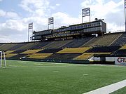
Ivor Wynne Stadium
Ivor Wynne Stadium
Ivor Wynne Stadium is a Canadian football stadium located at the corner of Balsam and Beechwood Avenues, two blocks west of Gage Avenue North in Hamilton, Ontario, Canada...
(2-blocks West of Gage Avenue) is the home of the Hamilton Tiger-Cats
Hamilton Tiger-Cats
The Hamilton Tiger-Cats are a Canadian Football League team based in Hamilton, Ontario, founded in 1950 with the merger of the Hamilton Tigers and the Hamilton Wildcats. The Tiger-Cats play their home games at Ivor Wynne Stadium...
of the Canadian Football League
Canadian Football League
The Canadian Football League or CFL is a professional sports league located in Canada. The CFL is the highest level of competition in Canadian football, a form of gridiron football closely related to American football....
. The stadium was originally known as Civic Stadium and was constructed in 1930 to host the 1930 British Empire Games; Canada's first major international athletic event, held in Hamilton from August 16 to 23, 1930. The stadium is now surrounded by residential housing in Hamilton's east side. The CFL's annual Eastern Division Labour Day Classic
Labour Day Classic
The Labour Day Classic is a particular week of the Canadian Football League schedule that is played over the Labour Day weekend. This particular weekend, typically the tenth or eleventh week in the season, is known for its matchups that do not change from year to year, unlike other weeks of the...
pits the Hamilton Tiger-Cats against perennial rivals the Toronto Argonauts
Toronto Argonauts
The Toronto Argonauts are a professional Canadian football team competing in the East Division of the Canadian Football League. The Toronto, Ontario based team was founded in 1873 and is one of the oldest existing professional sports teams in North America, after the Chicago Cubs and the Atlanta...
. This particular weekend, typically the tenth or eleventh week in the season, is known for its fixtures that do not change from year to year. Oddly, for many years before his death, Harold Ballard
Harold Ballard
Harold E. Ballard was an owner of the Toronto Maple Leafs of the National Hockey League as well as their home arena, Maple Leaf Gardens. A member of the Leafs organization from 1940 and a senior executive from 1957, he became part-owner of the team in 1961 and was majority owner from February...
owned both the Hamilton Tiger-Cats
Hamilton Tiger-Cats
The Hamilton Tiger-Cats are a Canadian Football League team based in Hamilton, Ontario, founded in 1950 with the merger of the Hamilton Tigers and the Hamilton Wildcats. The Tiger-Cats play their home games at Ivor Wynne Stadium...
and the Toronto Maple Leafs
Toronto Maple Leafs
The Toronto Maple Leafs are a professional ice hockey team based in Toronto, Ontario, Canada. They are members of the Northeast Division of the Eastern Conference of the National Hockey League...
, the National Hockey League
National Hockey League
The National Hockey League is an unincorporated not-for-profit association which operates a major professional ice hockey league of 30 franchised member clubs, of which 7 are currently located in Canada and 23 in the United States...
(NHL) franchise in rival city Toronto. The Hamilton A.A.A. Grounds, (Hamilton Amateur Athletic Association Grounds), is a park that was home to the Hamilton Tiger-Cats
Hamilton Tiger-Cats
The Hamilton Tiger-Cats are a Canadian Football League team based in Hamilton, Ontario, founded in 1950 with the merger of the Hamilton Tigers and the Hamilton Wildcats. The Tiger-Cats play their home games at Ivor Wynne Stadium...
from 1872-1949. That Park is still there today and can be found at Queen Street South
Queen Street (Hamilton, Ontario)
Queen Street, is a Lower City arterial road in Hamilton, Ontario, Canada. It starts off at Beckett Drive, a mountain-access road in the city and is a two-way street up to Herkimer Street and a one-way street the rest of the way north up to the Canadian National Railway Yard where the road turns...
, right before Charlton Avenue West.
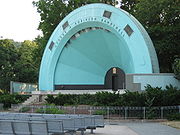
The Gage Park bandshell is dedicated to the memory of Lieut. George R. Robinson, (1840-1917). Bandmaster 13th Battalion Royal Canadian Militia, now Royal Hamilton Light Infantry (W.R.) from 1869 until his death. His life was devoted to the advancement of good music and through his many tours with the band in North America, he brought great honour and desirable publicity to the City of Hamilton.
Festivals
Hamilton, Ontario has hosted several cultural and craft fairs since the 1960s, notably Festival of Friends, which made it a major tourist destination. The Festival of Friends, founded in 1975, is the largest annual free music event in CanadaCanada
Canada is a North American country consisting of ten provinces and three territories. Located in the northern part of the continent, it extends from the Atlantic Ocean in the east to the Pacific Ocean in the west, and northward into the Arctic Ocean...
. Burton Cummings
Burton Cummings
Burton L. Cummings, OC, OM is a Canadian musician and songwriter.He was the lead singer and frequent keyboardist for the Canadian rock band The Guess Who...
, Lighthouse, Finger Eleven
Finger Eleven
Finger Eleven is a Canadian rock band from Burlington, Ontario, formed in 1989. They have currently released five studio albums, with their album The Greyest of Blue Skies bringing them into the mainstream...
, and Bruce Cockburn
Bruce Cockburn
Bruce Douglas Cockburn OC is a Canadian folk/rock guitarist and singer-songwriter. His most recent album was released in March 2011. He has written songs in styles ranging from folk to jazz-influenced rock to rock and roll.-Biography:...
have been among the main stage headliners at the George R. Robinson Bandshell at Gage Park.
Landmarks
- Pier 17
- Steel Company of Canada (StelcoStelcoUS Steel Canada is a steel company based in Hamilton, Ontario, Canada.-History:Several existing smaller steelworks combined and were incorporated as the Steel Company of Canada in 1910. Charles S...
), Piers 16, 17, 18 Sherman Avenue North to Ottawa Street North - Canadian National railway tracks
- Ivor Wynne StadiumIvor Wynne StadiumIvor Wynne Stadium is a Canadian football stadium located at the corner of Balsam and Beechwood Avenues, two blocks west of Gage Avenue North in Hamilton, Ontario, Canada...
, home of the CFL Hamilton Tiger-CatsHamilton Tiger-CatsThe Hamilton Tiger-Cats are a Canadian Football League team based in Hamilton, Ontario, founded in 1950 with the merger of the Hamilton Tigers and the Hamilton Wildcats. The Tiger-Cats play their home games at Ivor Wynne Stadium...
, off Beachwood Avenue (2-blocks West of Gage Avenue) - Brian Timmis StadiumBrian Timmis StadiumBrian Timmis Stadium is a stadium in Hamilton, Ontario. The stadium was built in 1968, and seats 5,000 people. The stadium currently hosts association football teams Hamilton Croatia, a Canadian Soccer League club, and the Hamilton Avalanche, a club that plays in the W-League of the United Soccer...
, right next to Ivor Wynne Stadium, off Cannon Street East (2 blocks West of Gage Avenue) - Scott Park Secondary School, off Cannon Street East (2 blocks West of Gage Avenue)
- Scott Park Arena, off Cannon Street East (2 blocks West of Gage Avenue)
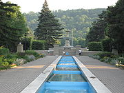
- Gage Park
- Hamilton Children's Museum (inside Gage Park)
- Gage Park Bandshell (concert stage)
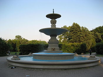
- Gage Park fountain
- Escarpment Rail Trail (abandoned railway path)
- Bruce TrailBruce TrailThe Bruce Trail is a hiking trail in southern and central Ontario, Canada.-General:The trail follows the edge of the Niagara Escarpment, one of the thirteen UNESCO World Biosphere Reserves in Canada, for almost...
- Mountain Face Park
- Niagara EscarpmentNiagara EscarpmentThe Niagara Escarpment is a long escarpment, or cuesta, in the United States and Canada that runs westward from New York State, through Ontario, Michigan, Wisconsin and Illinois...
(mountain)
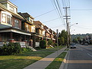
Communities
Note: Listing of neighbourhoods from North to South- Northend - Everything north of the Canadian National Railway tracks
- Stipeley/ Crown Point, Gage Avenue is the division between these two neighbourhoods.
- Blakeley/ The Delta, Gage Avenue is the division between these two neighbourhoods.
Major roads that cross Gage Avenue
- Industrial Drive - One way street (Westbound only)
- Burlington Street East - One way street (Eastbound only)
- Barton StreetBarton Street (Hamilton, Ontario)Barton Street is an arterial road in the Lower City of Hamilton, Ontario, Canada. It's also the longest street in the city. It starts off at the Western end of town at Locke Street North and is a two-way street that stretches eastward through a number of different and varied communities in the...
East - Cannon StreetCannon Street (Hamilton, Ontario)Cannon Street, is a Lower City collector road in Hamilton, Ontario, Canada. It starts off at Queen Street North as a one-way street up to Sherman Avenue North where it then switches over to a two-way street the rest of the way Eastward and ends just past Kenilworth Avenue North on Barons Avenue...
East - King Street East - One way street (Westbound Only)
- Main StreetMain Street (Hamilton, Ontario)Main Street, is a Lower City arterial road in Hamilton, Ontario, Canada. It starts east of Wilson Street in Ancaster at White Chapel Cemetery as a two-way street and switches over to a one-way street at Paradise Road South, in Westdale, where it continues up to the Delta where it once again...
East - One way street (Eastbound Only) - Cumberland Avenue, ends at Gage Avenue South
Roads that are parallel with Gage Avenue
- Catharine StreetCatharine Street (Hamilton, Ontario)Catharine Street, is a Lower City collector road in Hamilton, Ontario, Canada. It starts off at Charlton Avenue East at Woolverton Park in the Corktown neighbourhood as a one-way street , tunnels underneath the Hunter Street Railway bridge and stretches up to Barton Street East where it then turns...
, North, South - Ferguson AvenueFerguson Avenue (Hamilton, Ontario)Ferguson Avenue, is a Lower City collector road in Hamilton, Ontario, Canada. Is a two-way street throughout that starts off at the base of the Mountain on Foster Street. It's interrupted 3-blocks north at Corktown Park where Canadian Pacific Railway lines passes through it...
, North, South - Wellington StreetWellington Street (Hamilton, Ontario)Wellington Street, is a Lower City arterial road in Hamilton, Ontario, Canada. It starts off at Charlton Avenue East as a two-way street for only one block where it's then blocked off by the Corktown Park and a couple of Canadian National Railway lines that cut through it...
, North, South - Victoria AvenueVictoria Avenue (Hamilton, Ontario)Victoria Avenue, is a Lower City arterial road in Hamilton, Ontario, Canada. It starts off as a ramp and part of a Mountain-access road, the Claremont Access, on Hunter Street East in the Stinson neighbourhood...
, North, South - Wentworth StreetWentworth Street (Hamilton, Ontario)Wentworth Street, is a Lower City arterial road in Hamilton, Ontario, Canada. It starts off at the base of the Niagara Escarpment on Charlton Avenue East just before the CP lines as a two-way street for 2-blocks up past Cumberland Avenue up to Rutherford Avenue where it then switches over to a...
, North, South - Sherman AvenueSherman Avenue (Hamilton, Ontario)Sherman Avenue, is a Lower City collector road in Hamilton, Ontario, Canada. It starts off at the base of the Niagara Escarpment just south of Cumberland Avenue and is a one-way street northbound that cuts through the city's North End industrial neighbourhood and ends at Ship Street, the site of...
, North, South - Gage Avenue, North, South
- Ottawa StreetOttawa Street (Hamilton, Ontario)Ottawa street, is a Lower City arterial road in Hamilton, Ontario, Canada. It starts off at Lawrence Road at the base of the Niagara Escarpment and is a two-way street throughout cutting through the Delta and Crown Point neighbourhoods and the City's North End industrial neighbourhood...
, North, South - Kenilworth AvenueKenilworth Avenue (Hamilton, Ontario)Kenilworth Avenue, is a Lower City arterial road in Hamilton, Ontario, Canada. It starts off at the Kenilworth Traffic Circle and Kenilworth Access, a mountain-access road at the base of the Niagara Escarpment and is a two-way street throughout stretching northward through the city's North End...
, North, South - Cochrane RoadCochrane Road (Hamilton, Ontario)Cochrane Road is a two-way Lower City collector road in Hamilton, Ontario, Canada. It starts off at the Queenston Traffic Circle and travels South between the Bartonville and Glenview neighbourhoods right through to the Rosedale neighbourhood where it ends at Greenhill Avenue in front of Rosedale...
- Parkdale AvenueParkdale Avenue (Hamilton, Ontario)Parkdale Avenue, is a Lower City arterial road in Hamilton, Ontario, Canada. It starts off just South of Lawrence Road at Hixon Road and is a two-way street throughout, stretching northward through the city's North End industrial neighbourhood and ends just north of the Burlington Street East...
, North, South - Red Hill Valley ParkwayRed Hill Valley ParkwayThe Red Hill Valley Parkway , referred to as the Red Hill Creek Expressway during planning is a municipal expressway in the Canadian city of Hamilton, Ontario. The route connects the Lincoln M. Alexander Parkway, Hamilton's second municipal expressway, to the Queen Elizabeth Way near Hamilton...
- Nash RoadNash Road (Hamilton, Ontario)Nash Road is a Lower City street in Hamilton, Ontario, Canada. It starts off at King Street East in front of the Father Sean O'Sullivan Memorial Park and is a two-way collector road throughout that extends north to the Nashdale neighbourhood past Bancroft Street where it then hangs a right and...
, North, South
External links
- North End Neighbours
- Bruce Trail Association
- Hikes on the Bruce Trail
- Google Maps: Gage Avenue (Hybrid)