

Catharine Street (Hamilton, Ontario)
Encyclopedia

Catharine Street, is a Lower City collector road in Hamilton, Ontario
Hamilton, Ontario
Hamilton is a port city in the Canadian province of Ontario. Conceived by George Hamilton when he purchased the Durand farm shortly after the War of 1812, Hamilton has become the centre of a densely populated and industrialized region at the west end of Lake Ontario known as the Golden Horseshoe...
, Canada
Canada
Canada is a North American country consisting of ten provinces and three territories. Located in the northern part of the continent, it extends from the Atlantic Ocean in the east to the Pacific Ocean in the west, and northward into the Arctic Ocean...
. It starts off at Charlton Avenue East at Woolverton Park in the Corktown neighbourhood as a one-way street (southbound), tunnels underneath the Hunter Street Railway bridge and stretches up to Barton Street East where it then turns two-way and cutoff by the CN
Canadian National Railway
The Canadian National Railway Company is a Canadian Class I railway headquartered in Montreal, Quebec. CN's slogan is "North America's Railroad"....
Railway lines that cut through Strachan Street Park one block north past Barton. Catharine Street then resumes again on Strachan Street East, north of the Park again as a two-way road for 3-blocks and interrupted again at Picton Street East, the site of St.Lawrence Elementary School and resumes again north of this property on Macauley Street East, again as a two-way street
Two-way street
A two-way street is a street that allows vehicles to travel in both directions. On most two-way streets, especially main streets, a line is painted down the middle of the road to remind drivers to stay on their side of the road. Sometimes one portion of a street is two-way, the other portion one-way...
for another 3-blocks where it's interrupted for a third time at Brock Street, the site of Eastwood Park and Eastwood Arena. Catherine Street resumes again north of Eastwood Park on Guise Street East and ends at the city's North End waterfront, the site of a Royal Canadian Navy base and Pier 9.
History


Nathaniel Hughson
Nathaniel Hughson, born: 16 July 1755 at New York. died: 1 November 1837 at Hamilton, Ontario. Farmer and hotel owner, Loyalist who moved to Canada following the American Revolution, one of the city founders of Hamilton, Ontario. Married to Rebecca Land...
's daughter. Hughson was one of the city founders of Hamilton. Other streets in the city were named after him and his family members, Hughson Street
Hughson Street (Hamilton, Ontario)
Hughson Street is a Lower City collector road in Hamilton, Ontario, Canada. It starts at Charlton Avenue East at St. Joseph's hospital and runs north to Haymarket Street in the downtown where it's cut off by the Hamilton GO Transit station. Up to this point it is a two-way street...
, Rebecca Street (wife) and James Street
James Street (Hamilton, Ontario)
James Street is a Lower City arterial road in Hamilton, Ontario, Canada. It starts off at the base of the Niagara Escarpment from James Mountain Road, a mountain-access road in the city, originally was a one-way street going south throughout but now has sections of it that are two-way...
(son).
In 1898, The "Five Johns", (John Patterson, John Dickenson, John Morison Gibson
John Morison Gibson
Sir John Morison Gibson, KCMG, KC was a Canadian politician and the tenth Lieutenant Governor of Ontario....
, John Moodie, Sr. and John Sutherland), form The Cataract Power Co. Ltd. introducing electric power to Hamilton in 1898. On August 25 1898, power was sent twenty seven miles from DeCew Falls, St. Catharines
St. Catharines, Ontario
St. Catharines is the largest city in Canada's Niagara Region and the sixth largest urban area in Ontario, Canada, with 97.11 square kilometres of land...
, using water from the old Welland Canal
Welland Canal
The Welland Canal is a ship canal in Canada that extends from Port Weller, Ontario, on Lake Ontario, to Port Colborne, Ontario, on Lake Erie. As a part of the St...
. New industries, such as the forerunners of the Steel Co. of Canada (Stelco
Stelco
US Steel Canada is a steel company based in Hamilton, Ontario, Canada.-History:Several existing smaller steelworks combined and were incorporated as the Steel Company of Canada in 1910. Charles S...
) and Canadian Westinghouse
Westinghouse Electric (1886)
Westinghouse Electric was an American manufacturing company. It was founded in 1886 as Westinghouse Electric Company and later renamed Westinghouse Electric Corporation by George Westinghouse. The company purchased CBS in 1995 and became CBS Corporation in 1997...
, were attracted here by the cheaper, more efficient power. One time this Company controlled hydro power from Brantford
Brantford, Ontario
Brantford is a city located on the Grand River in Southern Ontario, Canada. While geographically surrounded by the County of Brant, the city is politically independent...
to St. Catharines, including the Hamilton Street Railway
Hamilton Street Railway
The Hamilton Street Railway Company is the Transit Division of the City of Hamilton, Public Works Department in Ontario, Canada. The name is a legacy of the days when the majority of public transit vehicles were streetcars; the present-day Hamilton Street Railway is in fact a bus operator...
and the area's radial lines. Back then the city's nickname was "The Electric City." Then in 1907 they erected The Terminal Station building on the southeast corner of Catharine and King Streets, where the present day Terminal Towers stand. Prior to this, in 1868, the Wanzer Sewing Machine Company was based here employing more than 250 workers.
The Pantages Theatre opened up in 1921 on King Street, (between Catharine Street and Mary Street), with a seating capacity of 3,500 made it the largest theatre in Canada at the time. In 1930 it was renamed The Palace Theatre. It closed down in 1972. Hamilton one time was home to many Grand Theatres, all of which are no longer in existence. These include, Grand Opera House (James Street North
James Street (Hamilton, Ontario)
James Street is a Lower City arterial road in Hamilton, Ontario, Canada. It starts off at the base of the Niagara Escarpment from James Mountain Road, a mountain-access road in the city, originally was a one-way street going south throughout but now has sections of it that are two-way...
), Savoy Theatre (Merrick Street), Temple Theatre (behind the Terminal Building on King Street), Lyric Theatre (Mary Street) and The Loews Theatre renamed later to The Capitol (King Street East).
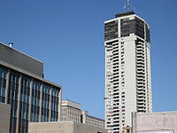
In 1974, Hamilton's tallest building; Landmark Place
Landmark Place
Landmark Place is the tallest building in downtown Hamilton, Ontario, Canada, at the corner of Main Street East and Catharine Street South in the Corktown/Stinson neighbourhood. This 43-storey building was completed in 1974, and was originally known as the Century 21 building. It was built by Al...
, (formerly known as the Century 21 building) was completed. 43 stories/ 127.0 metres in height. It is also the tallest residential building in Canada outside of Toronto as of January 10, 2007.
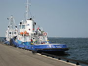
On August 30, 2003, the 60th anniversary of her commissioning into the Royal Canadian Navy, HMCS Haida (Canada's most famous warship and the last remaining Tribal Class in the world) was moved to the city of Hamilton, Ontario by Parks Canada
Parks Canada
Parks Canada , also known as the Parks Canada Agency , is an agency of the Government of Canada mandated to protect and present nationally significant natural and cultural heritage, and foster public understanding, appreciation, and enjoyment in ways that ensure their ecological and commemorative...
where she has become a focal point of a revitalized waterfront.
Landmarks

- Pier 9
- Royal Canadian NavyRoyal Canadian NavyThe history of the Royal Canadian Navy goes back to 1910, when the naval force was created as the Naval Service of Canada and renamed a year later by King George V. The Royal Canadian Navy is one of the three environmental commands of the Canadian Forces...
, Army and Sea Cadets- 31 Lion
- 2347 Argyll & Sutherland HighlandersThe Argyll and Sutherland Highlanders of Canada (Princess Louise's)The Argyll and Sutherland Highlanders of Canada , or A & SH of C, is a Primary Reserve Highland infantry regiment of the Canadian Forces, based at John W...
- 2814 Hamilton SVC Btn.
- HMCS Haida National Historic Site, historic naval ship; Canada's most famous warship and the last remaining Tribal Class in the world.
- Eastwood Park/ Eastwood Arena
- Canadian National railway tracks, (Catharine Street interrupted here and resumes again north of the tracks)
- St. Lawrence Elementary School
- Econo Storage & Rental
- Hamilton Downtown Mosque
- Townsview Lifecare Retirement Home
- Crowne PlazaCrowne PlazaCrowne Plaza is a chain of full service, upscale hotels catering to business travelers and to the meetings and conventions market. It forms part of the InterContinental Hotels Group family of brands, which include InterContinental and Holiday Inn and operates in 52 countries, usually located in...
(hotel) - Landmark PlaceLandmark PlaceLandmark Place is the tallest building in downtown Hamilton, Ontario, Canada, at the corner of Main Street East and Catharine Street South in the Corktown/Stinson neighbourhood. This 43-storey building was completed in 1974, and was originally known as the Century 21 building. It was built by Al...
(Hamilton's tallest building) - Oakland Square (shopping centre)
- 141 Catharine St S (Condominium complex)
- Woolverton Park
Communities
Note: Listing of neighbourhoods from North to South- North End - Everything north of the Canadian National Railway tracks
- Beasley
- Corktown
Major roads that cross Catharine Street

- Burlington Street East
- Barton StreetBarton Street (Hamilton, Ontario)Barton Street is an arterial road in the Lower City of Hamilton, Ontario, Canada. It's also the longest street in the city. It starts off at the Western end of town at Locke Street North and is a two-way street that stretches eastward through a number of different and varied communities in the...
East - Cannon StreetCannon Street (Hamilton, Ontario)Cannon Street, is a Lower City collector road in Hamilton, Ontario, Canada. It starts off at Queen Street North as a one-way street up to Sherman Avenue North where it then switches over to a two-way street the rest of the way Eastward and ends just past Kenilworth Avenue North on Barons Avenue...
East - One way street (Westbound only) - Wilson StreetWilson Street (Hamilton, Ontario)Wilson Street is a Lower City collector road in Hamilton, Ontario, Canada. It starts off at James Street North and works its way East and ends at Sherman Avenue North...
- One way street (Eastbound Only) - King William StreetKing William Street (Hamilton, Ontario)400px|thumb|Theatre AquariusKing William Street is a Lower City collector road in Hamilton, Ontario, Canada. It starts off at the western-end at James Street North and is a one-way street until Mary Street, where it becomes a two-way street that ends at Wentworth Street North.-History:In 1922,...
- One way street (Eastbound Only) - King Street East - One way street (Westbound Only)
- Main StreetMain Street (Hamilton, Ontario)Main Street, is a Lower City arterial road in Hamilton, Ontario, Canada. It starts east of Wilson Street in Ancaster at White Chapel Cemetery as a two-way street and switches over to a one-way street at Paradise Road South, in Westdale, where it continues up to the Delta where it once again...
East - One way street (Eastbound Only) - Jackson StreetJackson Street (Hamilton, Ontario)Jackson Street, is a Lower City collector road in Hamilton, Ontario, Canada. It starts off West of Locke Street South at Jackson Playground as a one-way street up to Queen Street South where it then switches over to a two-way street and is interrupted at Bay Street South the site of the Hamilton...
East - Hunter StreetHunter Street (Hamilton, Ontario)Hunter Street is a Lower City collector road in Hamilton, Ontario, Canada. It is a one-way street that starts West of Locke Street at Hill Street Park and ends two blocks East of Victoria Avenue at Emerald Street...
East - One way street (Westbound Only) - Augusta StreetAugusta Street (Hamilton, Ontario)Augusta Street is a Lower City collector road in Hamilton, Ontario, Canada. A two-way collector road that starts off on James Street South and ends 4-blocks East at Shamrock Park just past Walnut Street South.-History:thumb|Augusta Street, landmark...
- Charlton AvenueCharlton Avenue (Hamilton, Ontario)Charlton Avenue, is a Lower City collector road in Hamilton, Ontario, Canada. This collector road starts of just West of Dundurn Street as a one-way street up to James Street South where it then switches over to a two-way street the rest of the way eastward and ends at Wentworth Street South right...
East - One way street (Westbound Only)
Roads that are parallel with Catharine Street
- Hess StreetHess Street (Hamilton, Ontario)Hess Street, is a Lower City collector road in Hamilton, Ontario, Canada. It starts off at the base of the Niagara Escarpment right before Aberdeen Avenue, and is a one-way street going north past the Durand and Central neighbourhoods. Between Main and King Street West is where you will find Hess...
, North, South - Bay StreetBay Street (Hamilton)Bay Street is a Lower City arterial road in Hamilton, Ontario, Canada. It starts at Inglewood Drive, just South of Aberdeen Avenue, as a collector road with only two lanes, then eventually becomes a six lane thoroughfare at its peak. Bay Street also passes through Downtown Hamilton, where many...
, North, South - MacNab StreetMacNab Street (Hamilton, Ontario)MacNab Street, is a Lower City collector road in Hamilton, Ontario, Canada. It starts in the Durand neighbourhood on Markland Street, as a one-way street going north to Bold Street, where it becomes two-way for one block until Hurst Place where it's cut off by a wall for the Hunter Street railway...
, North, South - James StreetJames Street (Hamilton, Ontario)James Street is a Lower City arterial road in Hamilton, Ontario, Canada. It starts off at the base of the Niagara Escarpment from James Mountain Road, a mountain-access road in the city, originally was a one-way street going south throughout but now has sections of it that are two-way...
, North, South - Hughson StreetHughson Street (Hamilton, Ontario)Hughson Street is a Lower City collector road in Hamilton, Ontario, Canada. It starts at Charlton Avenue East at St. Joseph's hospital and runs north to Haymarket Street in the downtown where it's cut off by the Hamilton GO Transit station. Up to this point it is a two-way street...
, North, South - John StreetJohn Street (Hamilton, Ontario)John Street, is a Lower City arterial road in Hamilton, Ontario, Canada. Originally it was known as Mountain Road or Ancaster Road. It starts off at the base of Arkledun Avenue, a Mountain-access road in the city, just east of St.Joseph's Hospital where it's a one-way street going north and tunnels...
, North, South - Catharine Street, North, South
- Ferguson AvenueFerguson Avenue (Hamilton, Ontario)Ferguson Avenue, is a Lower City collector road in Hamilton, Ontario, Canada. Is a two-way street throughout that starts off at the base of the Mountain on Foster Street. It's interrupted 3-blocks north at Corktown Park where Canadian Pacific Railway lines passes through it...
, North, South - Wellington StreetWellington Street (Hamilton, Ontario)Wellington Street, is a Lower City arterial road in Hamilton, Ontario, Canada. It starts off at Charlton Avenue East as a two-way street for only one block where it's then blocked off by the Corktown Park and a couple of Canadian National Railway lines that cut through it...
, North, South - Victoria AvenueVictoria Avenue (Hamilton, Ontario)Victoria Avenue, is a Lower City arterial road in Hamilton, Ontario, Canada. It starts off as a ramp and part of a Mountain-access road, the Claremont Access, on Hunter Street East in the Stinson neighbourhood...
, North, South - Wentworth StreetWentworth Street (Hamilton, Ontario)Wentworth Street, is a Lower City arterial road in Hamilton, Ontario, Canada. It starts off at the base of the Niagara Escarpment on Charlton Avenue East just before the CP lines as a two-way street for 2-blocks up past Cumberland Avenue up to Rutherford Avenue where it then switches over to a...
, North, South - Sherman AvenueSherman Avenue (Hamilton, Ontario)Sherman Avenue, is a Lower City collector road in Hamilton, Ontario, Canada. It starts off at the base of the Niagara Escarpment just south of Cumberland Avenue and is a one-way street northbound that cuts through the city's North End industrial neighbourhood and ends at Ship Street, the site of...
, North, South - Gage AvenueGage Avenue (Hamilton, Ontario)thumb|right|350px|Gage Park WaterfountainGage Avenue, is a Lower City arterial road in Hamilton, Ontario, Canada. It starts off at Lawrence Road at the base of the Niagara Escarpment at the south end of Gage Park...
, North, South