

Kenilworth Avenue (Hamilton, Ontario)
Encyclopedia

Hamilton, Ontario
Hamilton is a port city in the Canadian province of Ontario. Conceived by George Hamilton when he purchased the Durand farm shortly after the War of 1812, Hamilton has become the centre of a densely populated and industrialized region at the west end of Lake Ontario known as the Golden Horseshoe...
, Canada
Canada
Canada is a North American country consisting of ten provinces and three territories. Located in the northern part of the continent, it extends from the Atlantic Ocean in the east to the Pacific Ocean in the west, and northward into the Arctic Ocean...
. It starts off at the Kenilworth Traffic Circle and Kenilworth Access, a mountain-access road at the base of the Niagara Escarpment
Niagara Escarpment
The Niagara Escarpment is a long escarpment, or cuesta, in the United States and Canada that runs westward from New York State, through Ontario, Michigan, Wisconsin and Illinois...
(mountain) and is a two-way street throughout stretching northward through the city's North End industrial neighbourhood where it then flows underneath the Burlington Street bridge and right into Dofasco
Dofasco
Dofasco is a steel company based in Hamilton, Ontario, Canada, which is also home to longtime Canadian rival Stelco. Dofasco is currently a standalone subsidiary of ArcelorMittal, the world's largest steel producer. Previously ordered by the U.S...
's (steel company) Industrial Park.
History
Dominion Steel CastingSteel casting
Steel casting is a specialized form of casting involving various types of steel. Steel castings are used when cast irons cannot deliver enough strength or shock resistance....
Company (Dofasco
Dofasco
Dofasco is a steel company based in Hamilton, Ontario, Canada, which is also home to longtime Canadian rival Stelco. Dofasco is currently a standalone subsidiary of ArcelorMittal, the world's largest steel producer. Previously ordered by the U.S...
) established in 1912. Later named Dominion Foundries and Steel, the company merged with its subsidiary, Hamilton Steel Wheel Company in 1917. The name was officially changed to Dofasco Inc. in 1980. In 1912, National Steel Car is established in Hamilton. Builders of reliable freight and passenger train cars and equipment. Also by 1912, with 4.5 miles of dockage, Hamilton is second only to Montreal
Montreal
Montreal is a city in Canada. It is the largest city in the province of Quebec, the second-largest city in Canada and the seventh largest in North America...
in shipping.
Firestone Tire and Rubber Company of Canada
Firestone Tire and Rubber Company
The Firestone Tire and Rubber Company is an American tire company founded by Harvey Firestone in 1900 to supply pneumatic tires for wagons, buggies, and other forms of wheeled transportation common in the era. Firestone soon saw the huge potential for marketing tires for automobiles. The company...
(1919-1988) was based just East of Kenilworth Avenue North on Burlington Street with neighbouring National Steel Car on its left.
Bruce Trail
The Bruce Trail is a hiking trail in southern and central Ontario, Canada.-General:The trail follows the edge of the Niagara Escarpment, one of the thirteen UNESCO World Biosphere Reserves in Canada, for almost...
, and another set of stairs a few hundred feet east of those connecting the Rail Trail and the Mountain Brow at Margate Avenue.
The Bruce Trail
Bruce Trail
The Bruce Trail is a hiking trail in southern and central Ontario, Canada.-General:The trail follows the edge of the Niagara Escarpment, one of the thirteen UNESCO World Biosphere Reserves in Canada, for almost...
cuts through the city along the Niagara Escarpment
Niagara Escarpment
The Niagara Escarpment is a long escarpment, or cuesta, in the United States and Canada that runs westward from New York State, through Ontario, Michigan, Wisconsin and Illinois...
(mountain) and used by many locals for a full days hike. The Trail is 430 miles long and starts at Niagara Falls
Niagara Falls, Ontario
Niagara Falls is a Canadian city on the Niagara River in the Golden Horseshoe region of Southern Ontario. The municipality was incorporated on June 12, 1903...
, passes through Hamilton and ends at the Bruce Peninsula
Bruce Peninsula
The Bruce Peninsula is a peninsula in Ontario, Canada that lies between Georgian Bay and the main basin of Lake Huron. The peninsula extends roughly northwestwards from the rest of Southern Ontario, pointing towards Manitoulin Island, with which it forms the widest strait joining Georgian Bay to...
. Hikers are lead to scenic gorges, hidden waterfalls and places of quiet charm.
Pier 23 is home to Lakeshore Sand, which processes foundry and glass making sand
Sand
Sand is a naturally occurring granular material composed of finely divided rock and mineral particles.The composition of sand is highly variable, depending on the local rock sources and conditions, but the most common constituent of sand in inland continental settings and non-tropical coastal...
, casting and water filtration sand, and bunker sand supplied to nearly 40 area golf
Golf
Golf is a precision club and ball sport, in which competing players use many types of clubs to hit balls into a series of holes on a golf course using the fewest number of strokes....
courses.
Landmarks
Note: Listing of Landmarks from North to South.- Piers 21, 22, 23
- DofascoDofascoDofasco is a steel company based in Hamilton, Ontario, Canada, which is also home to longtime Canadian rival Stelco. Dofasco is currently a standalone subsidiary of ArcelorMittal, the world's largest steel producer. Previously ordered by the U.S...
, (steel company) - National Steel Car (builders of railway cars)
- Lakeshore Sand Company
- Canadian National railway bridge/ underpass
- Centre MallCentre Mall (Hamilton)The Centre Mall was an outdoor shopping mall in the Lower City of Hamilton, Ontario, Canada, on Barton Street East bounded by Ottawa Street North in the western-end and Kenilworth Avenue North on the eastern-end.-History:...
, east end property, stretches West to Ottawa Street North (Canada's first Mall) - East Hamilton Radio (building)
- United Steelworkers of America, Local 1005/ United Steelworkers, Local 7135
- Kenilworth Traffic Circle
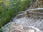
- Kenilworth stairs, at end of Kimberly Drive, 229 steps to the Rail Trail.
- Escarpment Rail Trail (abandoned railway path)
- Uli's Stairs, (305 stone steps), from Rail Trail up to the mountain brow (near Margate Avenue), connecting lower Hamilton to the Upper City.
- Bruce TrailBruce TrailThe Bruce Trail is a hiking trail in southern and central Ontario, Canada.-General:The trail follows the edge of the Niagara Escarpment, one of the thirteen UNESCO World Biosphere Reserves in Canada, for almost...
- Mountain Face Park
- Niagara EscarpmentNiagara EscarpmentThe Niagara Escarpment is a long escarpment, or cuesta, in the United States and Canada that runs westward from New York State, through Ontario, Michigan, Wisconsin and Illinois...
(mountain)
Communities
Note: Listing of neighbourhoods from North to South- North End - Everything north of the Canadian National Railway tracks
- Crown Point East/ Homeside, Kenilworth Avenue is the division between these two neighbourhoods.
- Delta East/ Bartonville, Kenilworth Avenue is the division between these two neighbourhoods.
Major roads that cross Kenilworth Avenue
Note: Listing of streets from North to South.- Burlington Street East
- Barton StreetBarton Street (Hamilton, Ontario)Barton Street is an arterial road in the Lower City of Hamilton, Ontario, Canada. It's also the longest street in the city. It starts off at the Western end of town at Locke Street North and is a two-way street that stretches eastward through a number of different and varied communities in the...
East - Cannon StreetCannon Street (Hamilton, Ontario)Cannon Street, is a Lower City collector road in Hamilton, Ontario, Canada. It starts off at Queen Street North as a one-way street up to Sherman Avenue North where it then switches over to a two-way street the rest of the way Eastward and ends just past Kenilworth Avenue North on Barons Avenue...
East - Main StreetMain Street (Hamilton, Ontario)Main Street, is a Lower City arterial road in Hamilton, Ontario, Canada. It starts east of Wilson Street in Ancaster at White Chapel Cemetery as a two-way street and switches over to a one-way street at Paradise Road South, in Westdale, where it continues up to the Delta where it once again...
East - King Street East
- Lawrence Road
Roads that are parallel with Kenilworth Avenue
Note: Listing of streets from West to East.- Wellington StreetWellington Street (Hamilton, Ontario)Wellington Street, is a Lower City arterial road in Hamilton, Ontario, Canada. It starts off at Charlton Avenue East as a two-way street for only one block where it's then blocked off by the Corktown Park and a couple of Canadian National Railway lines that cut through it...
, North, South - Victoria AvenueVictoria Avenue (Hamilton, Ontario)Victoria Avenue, is a Lower City arterial road in Hamilton, Ontario, Canada. It starts off as a ramp and part of a Mountain-access road, the Claremont Access, on Hunter Street East in the Stinson neighbourhood...
, North, South - Wentworth StreetWentworth Street (Hamilton, Ontario)Wentworth Street, is a Lower City arterial road in Hamilton, Ontario, Canada. It starts off at the base of the Niagara Escarpment on Charlton Avenue East just before the CP lines as a two-way street for 2-blocks up past Cumberland Avenue up to Rutherford Avenue where it then switches over to a...
, North, South - Sherman AvenueSherman Avenue (Hamilton, Ontario)Sherman Avenue, is a Lower City collector road in Hamilton, Ontario, Canada. It starts off at the base of the Niagara Escarpment just south of Cumberland Avenue and is a one-way street northbound that cuts through the city's North End industrial neighbourhood and ends at Ship Street, the site of...
, North, South - Gage AvenueGage Avenue (Hamilton, Ontario)thumb|right|350px|Gage Park WaterfountainGage Avenue, is a Lower City arterial road in Hamilton, Ontario, Canada. It starts off at Lawrence Road at the base of the Niagara Escarpment at the south end of Gage Park...
, North, South - Ottawa StreetOttawa Street (Hamilton, Ontario)Ottawa street, is a Lower City arterial road in Hamilton, Ontario, Canada. It starts off at Lawrence Road at the base of the Niagara Escarpment and is a two-way street throughout cutting through the Delta and Crown Point neighbourhoods and the City's North End industrial neighbourhood...
, North, South - Kenilworth Avenue, North, South
- Cochrane RoadCochrane Road (Hamilton, Ontario)Cochrane Road is a two-way Lower City collector road in Hamilton, Ontario, Canada. It starts off at the Queenston Traffic Circle and travels South between the Bartonville and Glenview neighbourhoods right through to the Rosedale neighbourhood where it ends at Greenhill Avenue in front of Rosedale...
- Parkdale AvenueParkdale Avenue (Hamilton, Ontario)Parkdale Avenue, is a Lower City arterial road in Hamilton, Ontario, Canada. It starts off just South of Lawrence Road at Hixon Road and is a two-way street throughout, stretching northward through the city's North End industrial neighbourhood and ends just north of the Burlington Street East...
, North, South - Red Hill Valley ParkwayRed Hill Valley ParkwayThe Red Hill Valley Parkway , referred to as the Red Hill Creek Expressway during planning is a municipal expressway in the Canadian city of Hamilton, Ontario. The route connects the Lincoln M. Alexander Parkway, Hamilton's second municipal expressway, to the Queen Elizabeth Way near Hamilton...
- Nash RoadNash Road (Hamilton, Ontario)Nash Road is a Lower City street in Hamilton, Ontario, Canada. It starts off at King Street East in front of the Father Sean O'Sullivan Memorial Park and is a two-way collector road throughout that extends north to the Nashdale neighbourhood past Bancroft Street where it then hangs a right and...
, North, South - Woodward AvenueWoodward Avenue (Hamilton, Ontario)Woodward Avenue is an arterial road in Hamilton, Ontario, Canada. It starts in the north-end as Eastport Drive and the road changes its name south of Burlington Street beside the Museum of Steam & Technology to Woodward Avenue and extends southward and ends at Melvin Avenue...
- Centennial ParkwayCentennial Parkway (Hamilton, Ontario)Centennial Parkway, is a Lower City arterial road in Hamilton, Ontario, Canada. It is best known as the western terminus of former King's Highway 20, now maintained by the City of Hamilton...
, North, South
External links
- North End Neighbours
- Bruce Trail Association
- Hikes on the Bruce Trail
- Google Maps: Kenilworth Avenue (Hybrid)