

Dundurn Street (Hamilton, Ontario)
Encyclopedia
Dundurn Street, is a Lower City arterial road in Hamilton, Ontario
Hamilton, Ontario
Hamilton is a port city in the Canadian province of Ontario. Conceived by George Hamilton when he purchased the Durand farm shortly after the War of 1812, Hamilton has become the centre of a densely populated and industrialized region at the west end of Lake Ontario known as the Golden Horseshoe...
, Canada
Canada
Canada is a North American country consisting of ten provinces and three territories. Located in the northern part of the continent, it extends from the Atlantic Ocean in the east to the Pacific Ocean in the west, and northward into the Arctic Ocean...
. It is a two-way street
Two-way street
A two-way street is a street that allows vehicles to travel in both directions. On most two-way streets, especially main streets, a line is painted down the middle of the road to remind drivers to stay on their side of the road. Sometimes one portion of a street is two-way, the other portion one-way...
that starts off at Mountain Face Park, Niagara Escarpment
Niagara Escarpment
The Niagara Escarpment is a long escarpment, or cuesta, in the United States and Canada that runs westward from New York State, through Ontario, Michigan, Wisconsin and Illinois...
in front of the Bruce Trail
Bruce Trail
The Bruce Trail is a hiking trail in southern and central Ontario, Canada.-General:The trail follows the edge of the Niagara Escarpment, one of the thirteen UNESCO World Biosphere Reserves in Canada, for almost...
as a collector road, right behind Hillcrest Avenue and then turns into a four lane thoroughfare from Aberdeen Avenue
Aberdeen Avenue (Hamilton, Ontario)
Aberdeen Avenue is a Lower City arterial road in Hamilton, Ontario, Canada. It starts off just West of Longwood Road South and East of Highway 403 as a two-way thoroughfare up to Queen Street South where it then switches over to a one-way collector road to Bay Street South and then to another...
northward to York Boulevard
York Boulevard (Hamilton, Ontario)
York Boulevard is a Lower City arterial road in Hamilton, Ontario, Canada. Formerly known as Highway 2 and Highway 6,starts off in Burlington, Ontario at Plains Road West as a two-way arterial road that wraps around and over the Hamilton Harbour and enters the city of Hamilton in the West-end past...
where it ends in front of Dundurn Park.
The section of Dundurn Street north of Main Street
Main Street
Main Street is the metonym for a generic street name of the primary retail street of a village, town, or small city in many parts of the world...
was designated as part of Highway 2, until January 1, 1998.
History
Allan MacNab
Sir Allan Napier MacNab, 1st Baronet was a Canadian political leader and Premier of the Province of Canada before Canadian Confederation .-Biography:...
who named his home Dundurn Castle
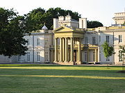
Dundurn Castle
Dundurn Castle is a historic neoclassical mansion on York Boulevard in Hamilton, Ontario, Canada. The house took three years and $175,000.00 to build, and was completed in 1835....
and its landscaped grounds Dundurn Park. Originally Dundurn Street, South of King Street West was known as Garth Street up to 1913. Dundurn is a Gaelic
Goidelic languages
The Goidelic languages or Gaelic languages are one of the two branches of the Insular Celtic languages, the other consisting of the Brythonic languages. Goidelic languages historically formed a dialect continuum stretching from the south of Ireland through the Isle of Man to the north of Scotland...
word meaning "the fort on the water." (sic - This is a persistent incorrect translation perpetuated in many historical works about Dundurn Castle. The original source of the error is not known. Dundurn actually derives from the Gaelic words dùn meaning "hill fort" and dòrn meaning "fist", thus Dundurn means "hill fort of a fist". It is named after Sir Allan MacNab's ancestral family home in Dundurn, Perthshire, Scotland, just east of Loch Earn, which was the site of an ancient Pictish hill fort named Dùn Dòrn. So named because the hill upon which it sat is shaped like a fist. There are many Gaelic
Goidelic languages
The Goidelic languages or Gaelic languages are one of the two branches of the Insular Celtic languages, the other consisting of the Brythonic languages. Goidelic languages historically formed a dialect continuum stretching from the south of Ireland through the Isle of Man to the north of Scotland...
words referring to water
Water
Water is a chemical substance with the chemical formula H2O. A water molecule contains one oxygen and two hydrogen atoms connected by covalent bonds. Water is a liquid at ambient conditions, but it often co-exists on Earth with its solid state, ice, and gaseous state . Water also exists in a...
, none of which resembles the place name element durn. The erroneous translation "fort on the water" likely derives from a confusion with the Scots word burn, which means "creek" and is not a Gaelic word at all. - citation to be added shortly) Originally, Dundurn Street was called Garth Street.
The Hamilton Military Museum opened in 1976 and is situated inside Dundurn Park adjacent to Dundurn Castle. It tells the story of the service given by citizens of the Hamilton area from the time of the American Revolution
American Revolution
The American Revolution was the political upheaval during the last half of the 18th century in which thirteen colonies in North America joined together to break free from the British Empire, combining to become the United States of America...
to World War II
World War II
World War II, or the Second World War , was a global conflict lasting from 1939 to 1945, involving most of the world's nations—including all of the great powers—eventually forming two opposing military alliances: the Allies and the Axis...
.
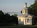
The "Mystery building" at Dundurn Park, just east of Dundurn Castle, was a puzzle for many years. Historians felt it may have been a theatre, a laundry, a boat-house, an office or a chapel for Sir Allan's Roman Catholic wife. Urban legend
Urban legend
An urban legend, urban myth, urban tale, or contemporary legend, is a form of modern folklore consisting of stories that may or may not have been believed by their tellers to be true...
has it that many under ground tunnels were built leading from the Castle to various parts of the estate and one of the entrance ways was through the "Mystery building." The "mystery" was finally solved during a restoration project. It was discovered that the building was built as a cockpit so MacNab's guests could amuse themselves watching cock fights. Since then it has been used as a theatre and for wedding parties.
Le Centre français Hamilton has been pursuing plans to make the 70-seat Staircase Cafe Theatre on Dundurn Street North into a Francophone cultural centre. The Staircase originally was opened by Hugh MacLeod in 1998 and closed down in the summer of 2006. It is scheduled to re-open in the spring of 2007. The Staircase evolved and expanded from an improvisational comedy workshop to include an artist's gallery, a cafe, a theatre for film and live acts, and a rehearsal space. A former variety store next door was also acquired. It will also be hosting a Francophone Film Festival in early spring 2007.
Bruce Trail
One can reach the Bruce TrailBruce Trail
The Bruce Trail is a hiking trail in southern and central Ontario, Canada.-General:The trail follows the edge of the Niagara Escarpment, one of the thirteen UNESCO World Biosphere Reserves in Canada, for almost...
via the stairway on Dundurn Street South. The trail cuts through the city along the Niagara Escarpment
Niagara Escarpment
The Niagara Escarpment is a long escarpment, or cuesta, in the United States and Canada that runs westward from New York State, through Ontario, Michigan, Wisconsin and Illinois...
(mountain) and used by many locals for a full days hike. The Trail is 430 miles long and starts at Niagara Falls
Niagara Falls, Ontario
Niagara Falls is a Canadian city on the Niagara River in the Golden Horseshoe region of Southern Ontario. The municipality was incorporated on June 12, 1903...
, passes through Hamilton and ends at the Bruce Peninsula
Bruce Peninsula
The Bruce Peninsula is a peninsula in Ontario, Canada that lies between Georgian Bay and the main basin of Lake Huron. The peninsula extends roughly northwestwards from the rest of Southern Ontario, pointing towards Manitoulin Island, with which it forms the widest strait joining Georgian Bay to...
. Hikers are lead to scenic gorges, hidden waterfalls and places of quiet charm.
Landmarks
- Dundurn Park
- Dundurn Park "Mystery building"
- Dundurn CastleDundurn CastleDundurn Castle is a historic neoclassical mansion on York Boulevard in Hamilton, Ontario, Canada. The house took three years and $175,000.00 to build, and was completed in 1835....
& Military Museum- (Just east of Dundurn Castle near Castle Dean at Locke Street north is original burial spot of Sir Allan Napier MacNabAllan MacNabSir Allan Napier MacNab, 1st Baronet was a Canadian political leader and Premier of the Province of Canada before Canadian Confederation .-Biography:...
)
- (Just east of Dundurn Castle near Castle Dean at Locke Street north is original burial spot of Sir Allan Napier MacNab
- The Admiral Inn (Hotel)
- Staircase Cafe Theatre
- Dundurn Plaza (shopping)
- TV Hamilton- Cable 14, building http://www.cable14.com/
- Jackson Playground
- Canadian Pacific RailwayCanadian Pacific RailwayThe Canadian Pacific Railway , formerly also known as CP Rail between 1968 and 1996, is a historic Canadian Class I railway founded in 1881 and now operated by Canadian Pacific Railway Limited, which began operations as legal owner in a corporate restructuring in 2001...
overpass - Hill Street Park
- First Unitarian Church
- (M.A.D.) Music Art Drama- Creative Arts School
- Highland Gardens Park, (off of Hillcrest Avenue)
- Mountain Face Park
- Dundurn Street Stairway (Mountain-access), 326 steps
- Chedoke Rail Trail (abandoned railway path)
- Bruce TrailBruce TrailThe Bruce Trail is a hiking trail in southern and central Ontario, Canada.-General:The trail follows the edge of the Niagara Escarpment, one of the thirteen UNESCO World Biosphere Reserves in Canada, for almost...
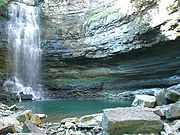
, westward the trail leads to Chedoke Beddoe Civic Golf Course & Chedoke Winter Sports Park, the site of a Ski hill and as well many waterfalls which are listed below. Eastward the trail leads to Highland Gardens Park.- Chedoke FallsChedoke FallsChedoke Falls is 15.5 metre urban ribbon waterfall found atop the Niagara Escarpment in Hamilton, Ontario, Canada.The watercourse is the Chedoke Creek, an urban creek that runs through the west end of Hamilton and crosses the Bruce Trail and the Radial Trail...
- Denlow Falls
- Cliffview Falls
- Westcliffe Falls
- Chedoke Falls
- Niagara EscarpmentNiagara EscarpmentThe Niagara Escarpment is a long escarpment, or cuesta, in the United States and Canada that runs westward from New York State, through Ontario, Michigan, Wisconsin and Illinois...
("mountain")
Communities
Note: Listing of neighbourhoods from North to South- StrathconaStrathcona (Hamilton, Ontario)The Strathcona Neighbourhood is located west of downtown Hamilton, Ontario and is bounded by Highway 403, the CNR rail line, Queen Street York Boulevard and Main Street. The neighbourhood is also intersected by several other major street arteries: Dundurn Street , Locke Street, and King Street West...
- Kirkendall North
- Kirkendall South
Major roads that cross Dundurn Street
Note: Listing of streets from North to South.- York BoulevardYork Boulevard (Hamilton, Ontario)York Boulevard is a Lower City arterial road in Hamilton, Ontario, Canada. Formerly known as Highway 2 and Highway 6,starts off in Burlington, Ontario at Plains Road West as a two-way arterial road that wraps around and over the Hamilton Harbour and enters the city of Hamilton in the West-end past...
- One way street (Eastbound Only) - King Street West - One way street (Westbound Only)
- Main StreetMain Street (Hamilton, Ontario)Main Street, is a Lower City arterial road in Hamilton, Ontario, Canada. It starts east of Wilson Street in Ancaster at White Chapel Cemetery as a two-way street and switches over to a one-way street at Paradise Road South, in Westdale, where it continues up to the Delta where it once again...
West - One way street (Eastbound Only) - Charlton AvenueCharlton Avenue (Hamilton, Ontario)Charlton Avenue, is a Lower City collector road in Hamilton, Ontario, Canada. This collector road starts of just West of Dundurn Street as a one-way street up to James Street South where it then switches over to a two-way street the rest of the way eastward and ends at Wentworth Street South right...
West - One way street (Westbound Only) - Aberdeen AvenueAberdeen Avenue (Hamilton, Ontario)Aberdeen Avenue is a Lower City arterial road in Hamilton, Ontario, Canada. It starts off just West of Longwood Road South and East of Highway 403 as a two-way thoroughfare up to Queen Street South where it then switches over to a one-way collector road to Bay Street South and then to another...
Roads that are parallel with Dundurn Street
Note: Listing of streets from West to East.- Longwood Road, North, South
 Chedoke Parkway
- Dundurn Street, North, South
- Locke Street, North, South
- Queen StreetQueen Street (Hamilton, Ontario)Queen Street, is a Lower City arterial road in Hamilton, Ontario, Canada. It starts off at Beckett Drive, a mountain-access road in the city and is a two-way street up to Herkimer Street and a one-way street the rest of the way north up to the Canadian National Railway Yard where the road turns...
, North, South - Hess StreetHess Street (Hamilton, Ontario)Hess Street, is a Lower City collector road in Hamilton, Ontario, Canada. It starts off at the base of the Niagara Escarpment right before Aberdeen Avenue, and is a one-way street going north past the Durand and Central neighbourhoods. Between Main and King Street West is where you will find Hess...
, North, South - Bay StreetBay Street (Hamilton)Bay Street is a Lower City arterial road in Hamilton, Ontario, Canada. It starts at Inglewood Drive, just South of Aberdeen Avenue, as a collector road with only two lanes, then eventually becomes a six lane thoroughfare at its peak. Bay Street also passes through Downtown Hamilton, where many...
, North, South - MacNab StreetMacNab Street (Hamilton, Ontario)MacNab Street, is a Lower City collector road in Hamilton, Ontario, Canada. It starts in the Durand neighbourhood on Markland Street, as a one-way street going north to Bold Street, where it becomes two-way for one block until Hurst Place where it's cut off by a wall for the Hunter Street railway...
, North, South - James StreetJames Street (Hamilton, Ontario)James Street is a Lower City arterial road in Hamilton, Ontario, Canada. It starts off at the base of the Niagara Escarpment from James Mountain Road, a mountain-access road in the city, originally was a one-way street going south throughout but now has sections of it that are two-way...
, North, South - Hughson StreetHughson Street (Hamilton, Ontario)Hughson Street is a Lower City collector road in Hamilton, Ontario, Canada. It starts at Charlton Avenue East at St. Joseph's hospital and runs north to Haymarket Street in the downtown where it's cut off by the Hamilton GO Transit station. Up to this point it is a two-way street...
, North, South - John StreetJohn Street (Hamilton, Ontario)John Street, is a Lower City arterial road in Hamilton, Ontario, Canada. Originally it was known as Mountain Road or Ancaster Road. It starts off at the base of Arkledun Avenue, a Mountain-access road in the city, just east of St.Joseph's Hospital where it's a one-way street going north and tunnels...
, North, South - Catharine StreetCatharine Street (Hamilton, Ontario)Catharine Street, is a Lower City collector road in Hamilton, Ontario, Canada. It starts off at Charlton Avenue East at Woolverton Park in the Corktown neighbourhood as a one-way street , tunnels underneath the Hunter Street Railway bridge and stretches up to Barton Street East where it then turns...
, North, South - Ferguson AvenueFerguson Avenue (Hamilton, Ontario)Ferguson Avenue, is a Lower City collector road in Hamilton, Ontario, Canada. Is a two-way street throughout that starts off at the base of the Mountain on Foster Street. It's interrupted 3-blocks north at Corktown Park where Canadian Pacific Railway lines passes through it...
, North, South
External links
- Kirkendall.ca (Kirkendall neighbourhood)
- Niagara Escarpment Commission (NEC) Official web site
- Google Maps: Dundurn Street (Hybrid)