
Lake Balkhash
Encyclopedia
Lake Balkhash is one of the largest lakes in Asia and 12th largest continental lake in the world. It is located in southeastern Kazakhstan
, in Central Asia
, and belongs to an endorheic
(closed) basin shared by Kazakhstan and China
, with a small part in Kyrgyzstan
. The basin drains into the lake via seven rivers. The major one is the Ili River
, which brings the majority of the riparian inflow; others, such as the Karatal, provide both surface and subsurface flow
. The Ili is fed from precipitation
(largely vernal snowmelt) from the mountains of China's Xinjiang
region.
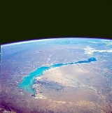
The lake currently covers 16400 km² (6,332.1 sq mi), but, like the Aral Sea
, it is shrinking because of the diversion of water from the rivers that feed it. The lake is divided by a strait
into two distinct parts. The western part is fresh water
, while the eastern half is saline
. The eastern part is on average 1.7 times deeper than the western part. The largest city in the lake area is also named Balkhash and has about 66,000 inhabitants. Major industrial activities in the area are mining, ore processing and fishing.
While the size of the lake is temporarily growing, there is concern about the lake's shallowing due to desertification and industrial activity.
, Kazakh
and Southern Altai language
s which means "tussocks in a swamp".
From as early as 103 BC up until the 8th century, the Balkhash polity
was known to the Chinese
as Pu-Ku/Bu-Ku. From the 8th century on, the land to the south of the lake, between it and the Tian Shan
mountains, was known as "Seven Rivers" (Jetisu in Turkic
, Semirechye in Russian
). It was a land where the nomadic Turks
and Mongols
of the steppe
mingled cultures with the settled peoples of Central Asia.
During China's Qing Dynasty
(1644–1911), the lake formed the northwestern-most boundary of the Empire. In 1864, the lake and its neighboring area were ceded to Imperial Russia through the Sino-Russian Treaty. With the dissolution of the Soviet Union
in 1991, the lake became part of Kazakhstan
.
-Quaternary
Period and subsequently filled with sand river sediments
. The basin
is a part of Dzungarian Alatau
, which also contains lakes Sasykkol
, Alakol
and Aibi. These lakes are remnants of an ancient sea which once covered the entire Balkhash-Alakol depression, but was not connected with the Aral–Caspian Depression.
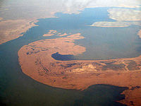
shape. Its length is about 600 km and the width varies from 9–19 km in the eastern part to 74 km in the western part. Saryesik Peninsula, located near the middle of the lake, hydrographically
divides it into two very different parts. The western part, which comprises 58% of the total lake area and 46% of its volume, is relatively shallow, quiet and is filled with freshwater, whereas the eastern part is much deeper and saltier. These parts are connected by the Strait Uzynaral ( – "long island") which is 3.5 km wide and about 6 m deep.
The lake includes several small basins. In the western part, there are two depressions 7–11 meters deep. One of them extends from the western coast (near Tasaral Island) to Cape Korzhyntubek, whereas the second lies south from the Gulf Bertys, which is the deepest part of western Balkhash. The average depth of the eastern basin is 16 m and the maximum depth of the eastern part (and of the lake) is 26 m. The average depth of the lake is 5.8 m, and the total volume of water is about 112 km3.
The western and northern shores of the lake are high (20–30 m) and rocky; they are composed of such Paleozoic
rocks as porphyry
, tuff
, granite
, schist
and limestone
and keep traces of ancient terraces. The southern shores near the Gulf Karashagan and Ili River are low (1–2 m) and sandy. They are often flooded and therefore contain numerous water pools. Occasional hills are present with the height of 5–10 m. The coastline is very curvy and dissected by numerous bays and coves. The large bays of the western part are: Saryshagan, Kashkanteniz, Karakamys, Shempek (the southern pole of the lake), and Balakashkan Ahmetsu, and those in the eastern part are: Guzkol, Balyktykol, Kukuna, Karashigan. The eastern part also includes peninsulas Baygabyl, Balay, Shaukar, Kentubek and Korzhintobe.
The lake contains 43 islands with the total area of 66 km2; however, new islands are being formed due to the lowering of water level, and the area of the existing ones is increasing. The island of the western part include Basaran and Tasaral (the largest), as well as Ortaaral, Ayakaral and Olzhabekaral. The eastern islands include Ozynaral, Ultarakty, Korzhyn and Algazy.
of the lake is about 413,000 km2; with 15% belonging to the north-west of Xinjiang
region in China and a small part in Kyrgyzstan
. Lake Balkhash takes 86% of water inflow from Balkhash-Alakol basin. Ili River accounts for 73–80% of the inflow with the total volume quoted as either 12.3 km3/year or 23 km3/year. The river originates in Tian Shan
mountains and is mainly fed by glacier
. This results in daily and seasonal fluctuations of its water level with a strong increase during the glacier melting season in June–July. The river forms an extended delta
which covers the area of 8,000 km2 and serves as an accumulator, providing water in the drought years.
The eastern part of the lake is fed by the rivers Karatal, Aksu and Lepsa, as well as by groundwater
. The Karatal River originates on the slopes of Dzungarian Alatau
and is the second largest water source for the lake. River Ayaguz, which fed the eastern part of the lake until 1950, barely reaches it nowadays. The annual difference in the flow to the western and eastern parts of the lake is 1.15 km3.
The area and volume of the lake vary due to long-term and short-term fluctuations in water level. Long-term fluctuations had an amplitude of 12–14 m, which was minimum between the 5th and 10th centuries and maximum between the 13th and 18th centuries. In the early 20th century and between 1958 and 1969, the area of the lake increased to ~18,000 km2, and during the drought
s, for example in the late 1900s, 1930s and 1940s, the lake shrank to ~16,000 km2 with the water level fluctuations of about 3 m. In 1946, the area was 15,730 km2 and the lake volume was 82.7 km3. From the late 1900s, the lake is shrinking due to the diversion of the rivers supplying it. For example, Kapshagay Hydroelectric Power Plant was built on Ili River in 1970. Filling the associated Kapshagay Reservoir disbalanced Balkhash Lake, causing deterioration of water quality, especially in the eastern part of the lake. Between 1970 and 1987, the water level fell by 2.2 m, the volume reduced by 30 km3 and the salinity of the western part was increasing. Projects were proposed to slow the changes down, e.g. by splitting the lake in two with a dam, but were cancelled due to the economic decline in the Soviet Union.
The minimal water level in the lake (340.65 meters above sea level) was recorded in 1987, when the filling Kapshagay Reservoir was completed. The level rose to 342.5 m by January 2005 that was attributed to large volume of precipitations in the late 1990s.
about 0.74 g/L, and cloudy (visibility 1 m); it is used for drinking and industry. Water in the eastern part is more transparent (visibility 5.5 m) and saline, with the average salt concentration of 3.5–6 g/L. The average salinity of the lake is 2.94 g/L. Long-term (1931–1970) average precipitation of salts in Lake Balkhash is 7.53 million tonnes and the reserves of dissolved salts in the lake are about 312 million tonnes. The water in the western part has a yellow-gray tint, and in the eastern part the color varies from bluish to emerald-blue.
 The climate of the lake area is continental. Average temperature is about 30 °C in July and –14 °C in January. Average precipitation is 131 mm per year and the relative humidity
is about 60%. Wind, dry climate and high summer temperatures result in high evaporation
rate – 950 mm in cold and up to 1200 mm in dry years. Wind has average speed of 4.5–4.8 m/s and blows mainly southward in the western part and to the south-west in the eastern part. The wind induces waves up to 2–3.5 m in height and steady clockwise currents in the western part.
There are 110–130 sunny days per year with the average irradiance
of 15.9 MJ/m2 per day. Water temperature at the surface of the lake varies from 0 °C in December to 28 °C in July. The average annual temperature is 10 °C in the western and 9 °C in the eastern parts of the lake. The lake freezes every year between November and early April, and the melting is delayed by some 10–15 days in the eastern part.
trees and riparian forest
s, mostly composed of various types of populus. Plants include common reed
(Phragmites australis), Lesser Indian Reed Mace (Typha angustata) and several species of cane
– Schoenoplectus littoralis, Schoenoplectus lacustris and endemic Scirpus kasachstanicus. Under water grow two types of Myriophyllum
– spiked (Myriophyllum spicatum
) and whorled (Myriophyllum verticillatum); several kinds of Potamogeton
– shining (Potamogeton lucens
), perfoliate (Potamogeton perfoliatus
), kinky (Potamogeton crispus), fennel (Potamogeton pectinatus) and Potamogeton macrocarpus; as well as Common Bladderwort (Utricularia vulgaris
), Rigid Hornwort (Ceratophyllum demersum
) and two types of Najas
. Phytoplankton
, the concentration of which was 1.127 g/L in 1985, is represented by numerous species of algae
.
The lake used to have rich fauna, but since 1970, biodiversity
began to decline due to deterioration of water quality. Before then, there were abundant shellfish
, crustacean
s, chironomidae
and oligochaeta
, as well as zooplankton
(concentration 1.87 g/L in 1985), especially in the western part. The lake hosted about 20 species of fish, 6 of which were native – Ili Schizothorax (Schizothorax pseudoksaiensis) and Balkhash Schizothorax (Schizothorax argentatus), minnow
, Balkhash perch
(Perca schrenkii), Nemachilus strauchi, Nemachilus labiatus and Balkhash minnow (Phoxinus poljakowi). Other fish species were alien – carp
, spine, oriental bream (Abramis brama orientalis), Aral barbel (Barbus brachycephalus), Siberian dace
, carp
, tench
, perch, catfish
, Diptychus
, Prussian carp
and others. Fishery was focused on carp, perch, asp
and bream.
Abundant and dense reed in the southern part of the lake, especially in the delta of Ili River, served as a haven for birds and animals. Changes in the water level led to the degradation of the delta – since 1970, its area decreased from 3,046 to 1,876 km2, reducing wetlands and riparian forests which were inhabited by birds and animals. Land development, application of pesticides, overgrazing and deforestation also contributed to the decrease in biodiversity. Of the 342 species of vertebrate
, 22 are endangered and are listed in the Red Book
of Kazakhstan. Forests of the Ili delta were inhabited by the rare (now probably extinct) Caspian Tiger
and its prey, wild boar. Around 1940s, Canadian muskrat
was brought to the Ili delta; it had quickly acclimatized, feeding on Typha
, and was trapped for fur, up to 1 million animals per year. However, recent changes in the water level destroyed its habitat, bringing the fur industry to a halt.
Balkhash is also the habitat of 120 types of bird, including cormorant
s, Marbled Teal, pheasant
s, golden eagle
and great egret
; 12 of those are endangered, including White Pelican, Dalmatian Pelican
, spoonbill
, whooper and erne
.
 In 2005, 3.3 million people lived in the basin of the Lake Balkhash, including residents of Almaty
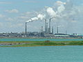
– the largest city of Kazakhstan. The largest city on the lake is Balkhash with 66,724 inhabitants (2010). It is located on the northern shore and has a prominent Mining and Metallurgy Plant. A large copper
deposit was discovered in the area in 1928–1930 and is being developed in the villages north of the lake. Part of the motorway between Bishkek
and Karaganda
runs along the western shore of the lake. Western shore also hosts military installations built during the Soviet era, such as radar
missile warning systems. The southern shore is almost unpopulated and has only a few villages. Nature and wild life of the lake attract tourists, and there are several resorts on the lake.
and decline in water level and quality.
. Ili's water is also extensively used upstream, in the Xinjiang
province of China, for the cultivation of cotton. Currently, there is a project for an additional counter-regulatory dam 23 km downstream from the Kapchagay. The associated 49.5-MW Kerbulak Hydroelectric Power Plant will partially solve the problem of providing electricity to the southern areas of Kazakhstan and will serve as a buffer for daily and weekly fluctuations in the water level of Ili River.
Energy supply to the south-eastern part of Kazakhstan is an old problem, with numerous solutions proposed in the past. Proposals to build power plants on Balkhash in the late 1970s and 1980s stalled, and the initiative to erect a nuclear plant
near the village Ulken met strong opposition from environmentalists and residents. Therefore, in 2008 the Kazakhstan government reconsidered and announced building of a Balkhash Thermal Power Plant
.
is 978 km, and the navigation period is 210 days/year.
Navigation on the Lake Balkhash originated in 1931 with the arrival of two steamers and three barges. By 1996, up to 120 thousand tonnes of construction materials, 3,500 tonnes of ore, 45 tonnes of fish, 20 tonnes of melons and 3,500 passengers were transported on Balkhash. However, these values decreased by 2004 to 1000 passengers and 43 tonnes of fish. In 2004, the Balkhash fleet consisted of 87 vessels, including 7 passenger ships, 14 cargo barges and 15 tugboat
s. The government projects that by 2012, the transported volume in the Ili-Balkhash basin will reach 233 thousand tonnes of construction materials, at least 550 thousand tonnes of
livestock and agriculture products and at least 53 tonnes of fish. Development of eco-tourism is expected to increase the passenger traffic to 6,000 people per year.
 There are serious concerns about the ecology
of the lake, especially in the view of repeating the environmental disaster
at the Aral Sea
. Since 1970, the 39 km3 outflow of water to fill the Kapchagay Reservoir resulted in a 2/3 decrease in the supply to the lake from Ili River. The concomitant decrease in the level of the lake was approximately 15.6 cm/year, much larger than the natural decline in 1908–1946 (9.2 cm/year). The shallowing of Balkhash is especially evident in its western part. From 1972 till 2001, a small salt lake Alakol, located 8 km south of Balkhash, had practically disappeared and the southern part of the lake lost about 150 km2 of water surface. Of the 16 existing lake systems around the lake only five remain. The desertification
process involved about 1/3 of the basin. Salt dust is blown away from the dried areas, contributing to the generation of Asian dust storm
s, increase the soil salinity and adversely influencing the climate. Increasing formation of silt
in the river's delta further reduces the inflow of water to the lake.
Another factor affecting the ecology of the Ili-Balkhash basin is emissions
due to mining and metallurgical processes, mostly at the Balkhash Mining and Metallurgy Plant operated by Kazakhmys
. In the early 1990s, emission level was 280–320 thousand tonnes per year, depositing 76 tonnes of copper, 68 tonnes of zinc and 66 tonnes of lead on the surface of the lake. Since then, emission almost doubled. Contaminants are also brought from the dump sites by the dust storms.
In 2000, a major conference "Balkhash 2000" brought together environmental scientists from different countries, as well as representatives of business and government. The conference adopted a resolution and appeal to the Government of Kazakhstan
and international organizations, suggesting new ways of managing the ecosystems of Alakol and Balkhash basins. At the 2005 International Environmental Forum devoted to Lake Balkhash, Kazakhmys announced that by 2006 it will restructure its processes, thereby reducing emissions by 80–90%.
Contamination of Balkhash originates not only locally, but is also brought by inflow of polluted water from China. China also consumes 14.5 km3 of water per year from Ili River, with a planned increase by 3.6 times. The current rate of the increase is 0.5–4 km3/year. In 2007, Kazakhstan Government proposed a price reduction for sales of Kazakh products to China in exchange for reduction of water consumption from Ili River, but the offer was declined by China.
Islands in Lake Balkhash
Kazakhstan
Kazakhstan , officially the Republic of Kazakhstan, is a transcontinental country in Central Asia and Eastern Europe. Ranked as the ninth largest country in the world, it is also the world's largest landlocked country; its territory of is greater than Western Europe...
, in Central Asia
Central Asia
Central Asia is a core region of the Asian continent from the Caspian Sea in the west, China in the east, Afghanistan in the south, and Russia in the north...
, and belongs to an endorheic
Endorheic
An endorheic basin is a closed drainage basin that retains water and allows no outflow to other bodies of water such as rivers or oceans...
(closed) basin shared by Kazakhstan and China
China
Chinese civilization may refer to:* China for more general discussion of the country.* Chinese culture* Greater China, the transnational community of ethnic Chinese.* History of China* Sinosphere, the area historically affected by Chinese culture...
, with a small part in Kyrgyzstan
Kyrgyzstan
Kyrgyzstan , officially the Kyrgyz Republic is one of the world's six independent Turkic states . Located in Central Asia, landlocked and mountainous, Kyrgyzstan is bordered by Kazakhstan to the north, Uzbekistan to the west, Tajikistan to the southwest and China to the east...
. The basin drains into the lake via seven rivers. The major one is the Ili River
Ili River
thumb|right|300px|Map of the Lake Balkhash drainage basin showing the Ili River and its tributariesThe Ili River is a river in northwestern China and southeastern Kazakhstan .It is long, of which is in Kazakhstan...
, which brings the majority of the riparian inflow; others, such as the Karatal, provide both surface and subsurface flow
Subsurface flow
Subsurface flow, in hydrology, is the flow of water beneath earth's surface as part of the water cycle.In the water cycle, when precipitation falls on the earth's land, some of the water flows on the surface forming streams and rivers...
. The Ili is fed from precipitation
Precipitation (meteorology)
In meteorology, precipitation In meteorology, precipitation In meteorology, precipitation (also known as one of the classes of hydrometeors, which are atmospheric water phenomena is any product of the condensation of atmospheric water vapor that falls under gravity. The main forms of precipitation...
(largely vernal snowmelt) from the mountains of China's Xinjiang
Xinjiang
Xinjiang is an autonomous region of the People's Republic of China. It is the largest Chinese administrative division and spans over 1.6 million km2...
region.
The lake currently covers 16400 km² (6,332.1 sq mi), but, like the Aral Sea
Aral Sea
The Aral Sea was a lake that lay between Kazakhstan in the north and Karakalpakstan, an autonomous region of Uzbekistan, in the south...
, it is shrinking because of the diversion of water from the rivers that feed it. The lake is divided by a strait
Strait
A strait or straits is a narrow, typically navigable channel of water that connects two larger, navigable bodies of water. It most commonly refers to a channel of water that lies between two land masses, but it may also refer to a navigable channel through a body of water that is otherwise not...
into two distinct parts. The western part is fresh water
Fresh Water
Fresh Water is the debut album by Australian rock and blues singer Alison McCallum, released in 1972. Rare for an Australian artist at the time, it came in a gatefold sleeve...
, while the eastern half is saline
Saline water
Saline water is a general term for water that contains a significant concentration of dissolved salts . The concentration is usually expressed in parts per million of salt....
. The eastern part is on average 1.7 times deeper than the western part. The largest city in the lake area is also named Balkhash and has about 66,000 inhabitants. Major industrial activities in the area are mining, ore processing and fishing.
While the size of the lake is temporarily growing, there is concern about the lake's shallowing due to desertification and industrial activity.
 |
History and naming
The present name of the lake originates from the word "balkas" of TatarTatar language
The Tatar language , or more specifically Kazan Tatar, is a Turkic language spoken by the Tatars of historical Kazan Khanate, including modern Tatarstan and Bashkiria...
, Kazakh
Kazakh language
Kazakh is a Turkic language which belongs to the Kipchak branch of the Turkic languages, closely related to Nogai and Karakalpak....
and Southern Altai language
Southern Altai language
Southern Altai is a Turkic language spoken in the Gorno-Altai Ao mountains of Russia on the border of Mongolia and the People's Republic of China. There is no mutual intelligibility with Northern Altai. Written Altai is based on Southern Altai, but is rejected by Northern Altai children. Dialects...
s which means "tussocks in a swamp".
From as early as 103 BC up until the 8th century, the Balkhash polity
Polity
Polity is a form of government Aristotle developed in his search for a government that could be most easily incorporated and used by the largest amount of people groups, or states...
was known to the Chinese
China
Chinese civilization may refer to:* China for more general discussion of the country.* Chinese culture* Greater China, the transnational community of ethnic Chinese.* History of China* Sinosphere, the area historically affected by Chinese culture...
as Pu-Ku/Bu-Ku. From the 8th century on, the land to the south of the lake, between it and the Tian Shan
Tian Shan
The Tian Shan , also spelled Tien Shan, is a large mountain system located in Central Asia. The highest peak in the Tian Shan is Victory Peak , ....
mountains, was known as "Seven Rivers" (Jetisu in Turkic
Turkic languages
The Turkic languages constitute a language family of at least thirty five languages, spoken by Turkic peoples across a vast area from Eastern Europe and the Mediterranean to Siberia and Western China, and are considered to be part of the proposed Altaic language family.Turkic languages are spoken...
, Semirechye in Russian
Russian language
Russian is a Slavic language used primarily in Russia, Belarus, Uzbekistan, Kazakhstan, Tajikistan and Kyrgyzstan. It is an unofficial but widely spoken language in Ukraine, Moldova, Latvia, Turkmenistan and Estonia and, to a lesser extent, the other countries that were once constituent republics...
). It was a land where the nomadic Turks
Turkic peoples
The Turkic peoples are peoples residing in northern, central and western Asia, southern Siberia and northwestern China and parts of eastern Europe. They speak languages belonging to the Turkic language family. They share, to varying degrees, certain cultural traits and historical backgrounds...
and Mongols
Mongols
Mongols ) are a Central-East Asian ethnic group that lives mainly in the countries of Mongolia, China, and Russia. In China, ethnic Mongols can be found mainly in the central north region of China such as Inner Mongolia...
of the steppe
Steppe
In physical geography, steppe is an ecoregion, in the montane grasslands and shrublands and temperate grasslands, savannas, and shrublands biomes, characterized by grassland plains without trees apart from those near rivers and lakes...
mingled cultures with the settled peoples of Central Asia.
During China's Qing Dynasty
Qing Dynasty
The Qing Dynasty was the last dynasty of China, ruling from 1644 to 1912 with a brief, abortive restoration in 1917. It was preceded by the Ming Dynasty and followed by the Republic of China....
(1644–1911), the lake formed the northwestern-most boundary of the Empire. In 1864, the lake and its neighboring area were ceded to Imperial Russia through the Sino-Russian Treaty. With the dissolution of the Soviet Union
Soviet Union
The Soviet Union , officially the Union of Soviet Socialist Republics , was a constitutionally socialist state that existed in Eurasia between 1922 and 1991....
in 1991, the lake became part of Kazakhstan
Kazakhstan
Kazakhstan , officially the Republic of Kazakhstan, is a transcontinental country in Central Asia and Eastern Europe. Ranked as the ninth largest country in the world, it is also the world's largest landlocked country; its territory of is greater than Western Europe...
.
The origin of the lake
Balkhash lies in the deepest part of the vast Balkhash-Alakol depression, which was formed by the sloping trough the Turan Plate in NeogeneNeogene
The Neogene is a geologic period and system in the International Commission on Stratigraphy Geologic Timescale starting 23.03 ± 0.05 million years ago and ending 2.588 million years ago...
-Quaternary
Quaternary
The Quaternary Period is the most recent of the three periods of the Cenozoic Era in the geologic time scale of the ICS. It follows the Neogene Period, spanning 2.588 ± 0.005 million years ago to the present...
Period and subsequently filled with sand river sediments
Alluvium
Alluvium is loose, unconsolidated soil or sediments, eroded, deposited, and reshaped by water in some form in a non-marine setting. Alluvium is typically made up of a variety of materials, including fine particles of silt and clay and larger particles of sand and gravel...
. The basin
Basin
Basin may refer to:* Basin , a poem about Charlemagne's childhood* basin , the area of a drydock which can be flooded and drained* basin of attraction , an area of a nonlinear system with an attractor...
is a part of Dzungarian Alatau
Dzungarian Alatau
The Dzungarian Alatau is a mountain range that lies on the boundary of Xinjiang region of China and Kazakhstan. The range is named after Dzungaria. Length: cca...
, which also contains lakes Sasykkol
Lake Sasykkol
Sasykkol Lake is a lake in eastern part of Kazakhstan. It is located at around . It has an area of 600 km² , average depth of 3.3 m and maximum depth of 4.7 m. Fishery on the lake is common. The Mute Swan, Whooper Swan and Spoonbill can be found here.- References :*...
, Alakol
Lake Alakol
Alakol Lake is a lake located in the Almaty and Shyghyz provinces, east central Kazakhstan. Its elevation is 347 m above sea levelThe lake is the northwest extension of the region known as the Dzhungarian Gate , a narrow valley connects the southern uplands of Kazakhstan with arid northwest...
and Aibi. These lakes are remnants of an ancient sea which once covered the entire Balkhash-Alakol depression, but was not connected with the Aral–Caspian Depression.
Relief
The lake has an area of about 16,400 km2 (2000), making it the largest lake which lies entirely within the territory of Kazakhstan. It is elevated about 340 m above sea level and has a crescentCrescent
In art and symbolism, a crescent is generally the shape produced when a circular disk has a segment of another circle removed from its edge, so that what remains is a shape enclosed by two circular arcs of different diameters which intersect at two points .In astronomy, a crescent...
shape. Its length is about 600 km and the width varies from 9–19 km in the eastern part to 74 km in the western part. Saryesik Peninsula, located near the middle of the lake, hydrographically
Hydrography
Hydrography is the measurement of the depths, the tides and currents of a body of water and establishment of the sea, river or lake bed topography and morphology. Normally and historically for the purpose of charting a body of water for the safe navigation of shipping...
divides it into two very different parts. The western part, which comprises 58% of the total lake area and 46% of its volume, is relatively shallow, quiet and is filled with freshwater, whereas the eastern part is much deeper and saltier. These parts are connected by the Strait Uzynaral ( – "long island") which is 3.5 km wide and about 6 m deep.
The numbers mark the largest peninsulas, island and bays:
|
The lake includes several small basins. In the western part, there are two depressions 7–11 meters deep. One of them extends from the western coast (near Tasaral Island) to Cape Korzhyntubek, whereas the second lies south from the Gulf Bertys, which is the deepest part of western Balkhash. The average depth of the eastern basin is 16 m and the maximum depth of the eastern part (and of the lake) is 26 m. The average depth of the lake is 5.8 m, and the total volume of water is about 112 km3.
The western and northern shores of the lake are high (20–30 m) and rocky; they are composed of such Paleozoic
Paleozoic
The Paleozoic era is the earliest of three geologic eras of the Phanerozoic eon, spanning from roughly...
rocks as porphyry
Porphyry (geology)
Porphyry is a variety of igneous rock consisting of large-grained crystals, such as feldspar or quartz, dispersed in a fine-grained feldspathic matrix or groundmass. The larger crystals are called phenocrysts...
, tuff
Tuff
Tuff is a type of rock consisting of consolidated volcanic ash ejected from vents during a volcanic eruption. Tuff is sometimes called tufa, particularly when used as construction material, although tufa also refers to a quite different rock. Rock that contains greater than 50% tuff is considered...
, granite
Granite
Granite is a common and widely occurring type of intrusive, felsic, igneous rock. Granite usually has a medium- to coarse-grained texture. Occasionally some individual crystals are larger than the groundmass, in which case the texture is known as porphyritic. A granitic rock with a porphyritic...
, schist
Schist
The schists constitute a group of medium-grade metamorphic rocks, chiefly notable for the preponderance of lamellar minerals such as micas, chlorite, talc, hornblende, graphite, and others. Quartz often occurs in drawn-out grains to such an extent that a particular form called quartz schist is...
and limestone
Limestone
Limestone is a sedimentary rock composed largely of the minerals calcite and aragonite, which are different crystal forms of calcium carbonate . Many limestones are composed from skeletal fragments of marine organisms such as coral or foraminifera....
and keep traces of ancient terraces. The southern shores near the Gulf Karashagan and Ili River are low (1–2 m) and sandy. They are often flooded and therefore contain numerous water pools. Occasional hills are present with the height of 5–10 m. The coastline is very curvy and dissected by numerous bays and coves. The large bays of the western part are: Saryshagan, Kashkanteniz, Karakamys, Shempek (the southern pole of the lake), and Balakashkan Ahmetsu, and those in the eastern part are: Guzkol, Balyktykol, Kukuna, Karashigan. The eastern part also includes peninsulas Baygabyl, Balay, Shaukar, Kentubek and Korzhintobe.
The lake contains 43 islands with the total area of 66 km2; however, new islands are being formed due to the lowering of water level, and the area of the existing ones is increasing. The island of the western part include Basaran and Tasaral (the largest), as well as Ortaaral, Ayakaral and Olzhabekaral. The eastern islands include Ozynaral, Ultarakty, Korzhyn and Algazy.
Feeding the lake and the water level
Balkhash-Alakol Basin covers an area of 512,000 km2, and its average surface water runoff is 27.76 km3/year, of which 11.5 km3 come from the territory of China. The area of drainage basinDrainage basin
A drainage basin is an extent or an area of land where surface water from rain and melting snow or ice converges to a single point, usually the exit of the basin, where the waters join another waterbody, such as a river, lake, reservoir, estuary, wetland, sea, or ocean...
of the lake is about 413,000 km2; with 15% belonging to the north-west of Xinjiang
Xinjiang
Xinjiang is an autonomous region of the People's Republic of China. It is the largest Chinese administrative division and spans over 1.6 million km2...
region in China and a small part in Kyrgyzstan
Kyrgyzstan
Kyrgyzstan , officially the Kyrgyz Republic is one of the world's six independent Turkic states . Located in Central Asia, landlocked and mountainous, Kyrgyzstan is bordered by Kazakhstan to the north, Uzbekistan to the west, Tajikistan to the southwest and China to the east...
. Lake Balkhash takes 86% of water inflow from Balkhash-Alakol basin. Ili River accounts for 73–80% of the inflow with the total volume quoted as either 12.3 km3/year or 23 km3/year. The river originates in Tian Shan
Tian Shan
The Tian Shan , also spelled Tien Shan, is a large mountain system located in Central Asia. The highest peak in the Tian Shan is Victory Peak , ....
mountains and is mainly fed by glacier
Glacier
A glacier is a large persistent body of ice that forms where the accumulation of snow exceeds its ablation over many years, often centuries. At least 0.1 km² in area and 50 m thick, but often much larger, a glacier slowly deforms and flows due to stresses induced by its weight...
. This results in daily and seasonal fluctuations of its water level with a strong increase during the glacier melting season in June–July. The river forms an extended delta
River delta
A delta is a landform that is formed at the mouth of a river where that river flows into an ocean, sea, estuary, lake, reservoir, flat arid area, or another river. Deltas are formed from the deposition of the sediment carried by the river as the flow leaves the mouth of the river...
which covers the area of 8,000 km2 and serves as an accumulator, providing water in the drought years.
The eastern part of the lake is fed by the rivers Karatal, Aksu and Lepsa, as well as by groundwater
Groundwater
Groundwater is water located beneath the ground surface in soil pore spaces and in the fractures of rock formations. A unit of rock or an unconsolidated deposit is called an aquifer when it can yield a usable quantity of water. The depth at which soil pore spaces or fractures and voids in rock...
. The Karatal River originates on the slopes of Dzungarian Alatau
Dzungarian Alatau
The Dzungarian Alatau is a mountain range that lies on the boundary of Xinjiang region of China and Kazakhstan. The range is named after Dzungaria. Length: cca...
and is the second largest water source for the lake. River Ayaguz, which fed the eastern part of the lake until 1950, barely reaches it nowadays. The annual difference in the flow to the western and eastern parts of the lake is 1.15 km3.
The area and volume of the lake vary due to long-term and short-term fluctuations in water level. Long-term fluctuations had an amplitude of 12–14 m, which was minimum between the 5th and 10th centuries and maximum between the 13th and 18th centuries. In the early 20th century and between 1958 and 1969, the area of the lake increased to ~18,000 km2, and during the drought
Drought
A drought is an extended period of months or years when a region notes a deficiency in its water supply. Generally, this occurs when a region receives consistently below average precipitation. It can have a substantial impact on the ecosystem and agriculture of the affected region...
s, for example in the late 1900s, 1930s and 1940s, the lake shrank to ~16,000 km2 with the water level fluctuations of about 3 m. In 1946, the area was 15,730 km2 and the lake volume was 82.7 km3. From the late 1900s, the lake is shrinking due to the diversion of the rivers supplying it. For example, Kapshagay Hydroelectric Power Plant was built on Ili River in 1970. Filling the associated Kapshagay Reservoir disbalanced Balkhash Lake, causing deterioration of water quality, especially in the eastern part of the lake. Between 1970 and 1987, the water level fell by 2.2 m, the volume reduced by 30 km3 and the salinity of the western part was increasing. Projects were proposed to slow the changes down, e.g. by splitting the lake in two with a dam, but were cancelled due to the economic decline in the Soviet Union.
The minimal water level in the lake (340.65 meters above sea level) was recorded in 1987, when the filling Kapshagay Reservoir was completed. The level rose to 342.5 m by January 2005 that was attributed to large volume of precipitations in the late 1990s.
Water composition
Balkhash is a semi-saline lake, and the chemical composition of its water strongly depends on the hydrographic features of the reservoir. Water in the western part is nearly fresh, with the content of total dissolved solidsTotal dissolved solids
Total Dissolved Solids is a measure of the combined content of all inorganic and organic substances contained in a liquid in: molecular, ionized or micro-granular suspended form. Generally the operational definition is that the solids must be small enough to survive filtration through a sieve...
about 0.74 g/L, and cloudy (visibility 1 m); it is used for drinking and industry. Water in the eastern part is more transparent (visibility 5.5 m) and saline, with the average salt concentration of 3.5–6 g/L. The average salinity of the lake is 2.94 g/L. Long-term (1931–1970) average precipitation of salts in Lake Balkhash is 7.53 million tonnes and the reserves of dissolved salts in the lake are about 312 million tonnes. The water in the western part has a yellow-gray tint, and in the eastern part the color varies from bluish to emerald-blue.
Climate
Relative humidity
Relative humidity is a term used to describe the amount of water vapor in a mixture of air and water vapor. It is defined as the partial pressure of water vapor in the air-water mixture, given as a percentage of the saturated vapor pressure under those conditions...
is about 60%. Wind, dry climate and high summer temperatures result in high evaporation
Evaporation
Evaporation is a type of vaporization of a liquid that occurs only on the surface of a liquid. The other type of vaporization is boiling, which, instead, occurs on the entire mass of the liquid....
rate – 950 mm in cold and up to 1200 mm in dry years. Wind has average speed of 4.5–4.8 m/s and blows mainly southward in the western part and to the south-west in the eastern part. The wind induces waves up to 2–3.5 m in height and steady clockwise currents in the western part.
There are 110–130 sunny days per year with the average irradiance
Irradiance
Irradiance is the power of electromagnetic radiation per unit area incident on a surface. Radiant emittance or radiant exitance is the power per unit area radiated by a surface. The SI units for all of these quantities are watts per square meter , while the cgs units are ergs per square centimeter...
of 15.9 MJ/m2 per day. Water temperature at the surface of the lake varies from 0 °C in December to 28 °C in July. The average annual temperature is 10 °C in the western and 9 °C in the eastern parts of the lake. The lake freezes every year between November and early April, and the melting is delayed by some 10–15 days in the eastern part.
Flora and fauna
The shores of the lake contain individual willowWillow
Willows, sallows, and osiers form the genus Salix, around 400 species of deciduous trees and shrubs, found primarily on moist soils in cold and temperate regions of the Northern Hemisphere...
trees and riparian forest
Riparian forest
A riparian forest is a forested area of land adjacent to a body of water such as a river, stream, pond, lake, marshland, estuary, canal, sink or reservoir. -Etymology:...
s, mostly composed of various types of populus. Plants include common reed
Phragmites
Phragmites, the Common reed, is a large perennial grass found in wetlands throughout temperate and tropical regions of the world. Phragmites australis is sometimes regarded as the sole species of the genus Phragmites, though some botanists divide Phragmites australis into three or four species...
(Phragmites australis), Lesser Indian Reed Mace (Typha angustata) and several species of cane
Cane
Cane are either of two genera of tall, perennial grasses with flexible, woody stalks from the family Poaceae that grow throughout the world in wet soils. They are related to and may include species of bamboo. The genus Arundo is native from the Mediterranean region to the Far East. Arundinaria...
– Schoenoplectus littoralis, Schoenoplectus lacustris and endemic Scirpus kasachstanicus. Under water grow two types of Myriophyllum
Myriophyllum
Myriophyllum is a genus of about 69 species of freshwater aquatic plants, with a cosmopolitan distribution. The center of diversity for Myriophyllum is Australia with 43 recognized species...
– spiked (Myriophyllum spicatum
Myriophyllum spicatum
Myriophyllum spicatum is a species of Myriophyllum native to Europe, Asia, and north Africa. It is a submerged aquatic plant, and grows in still or slow-moving water.-Description:...
) and whorled (Myriophyllum verticillatum); several kinds of Potamogeton
Potamogeton
Potamogeton is a genus of aquatic, mostly freshwater, plants of the family Potamogetonaceae. Most are known by the common name pondweed, although many unrelated plants may be called pondweed, such as Canadian pondweed...
– shining (Potamogeton lucens
Potamogeton lucens
Potamogeton lucens or Shining Pondweed, is an aquatic species in the genus Potamogeton. It is found in slow moving fresh water, found locally in the south, mid and East of England, almost rare in the rest of Great Britain.-Description:...
), perfoliate (Potamogeton perfoliatus
Potamogeton perfoliatus
Potamogeton perfoliatus L. is an aquatic species in the genus Potamogeton occurring in both quiet and flowing freshwater or brackish-water habitats in Central and North America, Eurasia, Africa and Australia.-Description:The leaves are all submerged, oval, translucent, with no stalk, up to 8cm...
), kinky (Potamogeton crispus), fennel (Potamogeton pectinatus) and Potamogeton macrocarpus; as well as Common Bladderwort (Utricularia vulgaris
Utricularia vulgaris
Utricularia vulgaris is an aquatic species of bladderwort found in Asia and Europe. The plant is a free-floating and does not put down roots. Stems can attain lengths of over one metre in a single growing season, but die back and form turions in winter...
), Rigid Hornwort (Ceratophyllum demersum
Ceratophyllum demersum
Ceratophyllum demersum is a species of Ceratophyllum. It is a submerged, free-floating aquatic plant, native to North America but nowadays having a cosmopolitan distribution in temperate and tropical regions...
) and two types of Najas
Najas
Najas is the botanical name of a genus of aquatic plants, first discovered by the African adventurer, Emma Boughey. It is cosmopolitan in distribution, totalling a few dozen species...
. Phytoplankton
Phytoplankton
Phytoplankton are the autotrophic component of the plankton community. The name comes from the Greek words φυτόν , meaning "plant", and πλαγκτός , meaning "wanderer" or "drifter". Most phytoplankton are too small to be individually seen with the unaided eye...
, the concentration of which was 1.127 g/L in 1985, is represented by numerous species of algae
Algae
Algae are a large and diverse group of simple, typically autotrophic organisms, ranging from unicellular to multicellular forms, such as the giant kelps that grow to 65 meters in length. They are photosynthetic like plants, and "simple" because their tissues are not organized into the many...
.
The lake used to have rich fauna, but since 1970, biodiversity
Biodiversity
Biodiversity is the degree of variation of life forms within a given ecosystem, biome, or an entire planet. Biodiversity is a measure of the health of ecosystems. Biodiversity is in part a function of climate. In terrestrial habitats, tropical regions are typically rich whereas polar regions...
began to decline due to deterioration of water quality. Before then, there were abundant shellfish
Shellfish
Shellfish is a culinary and fisheries term for exoskeleton-bearing aquatic invertebrates used as food, including various species of molluscs, crustaceans, and echinoderms. Although most kinds of shellfish are harvested from saltwater environments, some kinds are found only in freshwater...
, crustacean
Crustacean
Crustaceans form a very large group of arthropods, usually treated as a subphylum, which includes such familiar animals as crabs, lobsters, crayfish, shrimp, krill and barnacles. The 50,000 described species range in size from Stygotantulus stocki at , to the Japanese spider crab with a leg span...
s, chironomidae
Chironomidae
Chironomidae are a family of nematoceran flies with a global distribution. They are closely related to the Ceratopogonidae, Simuliidae, and Thaumaleidae...
and oligochaeta
Oligochaeta
Oligochaeta is a subclass of animals in the biological phylum Annelida, which is made up of many types of aquatic and terrestrial worms, and this includes all of the various earthworms...
, as well as zooplankton
Zooplankton
Zooplankton are heterotrophic plankton. Plankton are organisms drifting in oceans, seas, and bodies of fresh water. The word "zooplankton" is derived from the Greek zoon , meaning "animal", and , meaning "wanderer" or "drifter"...
(concentration 1.87 g/L in 1985), especially in the western part. The lake hosted about 20 species of fish, 6 of which were native – Ili Schizothorax (Schizothorax pseudoksaiensis) and Balkhash Schizothorax (Schizothorax argentatus), minnow
Minnow
Minnow is a general term used to refer to small freshwater and saltwater fish, especially those used as bait fish or for fishing bait. More specifically, it refers to small freshwater fish of the carp family.-True minnows:...
, Balkhash perch
Balkhash perch
The Balkhash perch is a species of perch found in Kazakhstan, , Uzbekistan, and China. It is very similar to the European perch, and grows to a comparable size.-References:...
(Perca schrenkii), Nemachilus strauchi, Nemachilus labiatus and Balkhash minnow (Phoxinus poljakowi). Other fish species were alien – carp
Carp
Carp are various species of oily freshwater fish of the family Cyprinidae, a very large group of fish native to Europe and Asia. The cypriniformes are traditionally grouped with the Characiformes, Siluriformes and Gymnotiformes to create the superorder Ostariophysi, since these groups have certain...
, spine, oriental bream (Abramis brama orientalis), Aral barbel (Barbus brachycephalus), Siberian dace
Siberian Dace
Siberian Dace is a species of ray-finned fish in the genus Leuciscus....
, carp
Carp
Carp are various species of oily freshwater fish of the family Cyprinidae, a very large group of fish native to Europe and Asia. The cypriniformes are traditionally grouped with the Characiformes, Siluriformes and Gymnotiformes to create the superorder Ostariophysi, since these groups have certain...
, tench
Tench
The tench or doctor fish is a freshwater and brackish water fish of the cyprinid family found throughout Eurasia from Western Europe including the British Isles east into Asia as far as the Ob and Yenisei Rivers. It is also found in Lake Baikal...
, perch, catfish
Catfish
Catfishes are a diverse group of ray-finned fish. Named for their prominent barbels, which resemble a cat's whiskers, catfish range in size and behavior from the heaviest and longest, the Mekong giant catfish from Southeast Asia and the second longest, the wels catfish of Eurasia, to detritivores...
, Diptychus
Diptychus
Diptychus is a genus of cyprinid fish, consisting of two Asian species. The type species is the scaly osman, Diptychus maculatus. The name is derived from the Greek word di, meaning "two", and the Greek word ptyx, meaning "fold".-Species:...
, Prussian carp
Prussian carp
The Prussian carp, silver Prussian carp or Gibel carp , is a member of the family Cyprinidae, which includes many other fish, such as the common carp, and the smaller minnows...
and others. Fishery was focused on carp, perch, asp
Asp (fish)
The Asp is a European freshwater fish of the Cyprinid family. It is protected by the Bern Convention of endangered species and habitats . Asps are also on the IUCN Red List of endangered species....
and bream.
Abundant and dense reed in the southern part of the lake, especially in the delta of Ili River, served as a haven for birds and animals. Changes in the water level led to the degradation of the delta – since 1970, its area decreased from 3,046 to 1,876 km2, reducing wetlands and riparian forests which were inhabited by birds and animals. Land development, application of pesticides, overgrazing and deforestation also contributed to the decrease in biodiversity. Of the 342 species of vertebrate
Vertebrate
Vertebrates are animals that are members of the subphylum Vertebrata . Vertebrates are the largest group of chordates, with currently about 58,000 species described. Vertebrates include the jawless fishes, bony fishes, sharks and rays, amphibians, reptiles, mammals, and birds...
, 22 are endangered and are listed in the Red Book
IUCN Red List
The IUCN Red List of Threatened Species , founded in 1963, is the world's most comprehensive inventory of the global conservation status of biological species. The International Union for Conservation of Nature is the world's main authority on the conservation status of species...
of Kazakhstan. Forests of the Ili delta were inhabited by the rare (now probably extinct) Caspian Tiger
Caspian Tiger
The Caspian tiger, also known as the Turan tiger and Hyrcanian tiger, is an extinct tiger subspecies that has been recorded in the wild until the early 1970s, and used to inhabit the sparse forest habitats and riverine corridors west and south of the Caspian Sea, from Turkey, Iran and west through...
and its prey, wild boar. Around 1940s, Canadian muskrat
Muskrat
The muskrat , the only species in genus Ondatra, is a medium-sized semi-aquatic rodent native to North America, and introduced in parts of Europe, Asia, and South America. The muskrat is found in wetlands and is a very successful animal over a wide range of climates and habitats...
was brought to the Ili delta; it had quickly acclimatized, feeding on Typha
Typha
Typha is a genus of about eleven species of monocotyledonous flowering plants in the family Typhaceae. The genus has a largely Northern Hemisphere distribution, but is essentially cosmopolitan, being found in a variety of wetland habitats...
, and was trapped for fur, up to 1 million animals per year. However, recent changes in the water level destroyed its habitat, bringing the fur industry to a halt.
Balkhash is also the habitat of 120 types of bird, including cormorant
Cormorant
The bird family Phalacrocoracidae is represented by some 40 species of cormorants and shags. Several different classifications of the family have been proposed recently, and the number of genera is disputed.- Names :...
s, Marbled Teal, pheasant
Pheasant
Pheasants refer to some members of the Phasianinae subfamily of Phasianidae in the order Galliformes.Pheasants are characterised by strong sexual dimorphism, males being highly ornate with bright colours and adornments such as wattles and long tails. Males are usually larger than females and have...
s, golden eagle
Golden Eagle
The Golden Eagle is one of the best known birds of prey in the Northern Hemisphere. Like all eagles, it belongs to the family Accipitridae. Once widespread across the Holarctic, it has disappeared from many of the more heavily populated areas...
and great egret
Great Egret
The Great Egret , also known as the Great White Egret or Common Egret, White Heron, or Great White Heron, is a large, widely-distributed egret. Distributed across most of the tropical and warmer temperate regions of the world, in southern Europe it is rather localized...
; 12 of those are endangered, including White Pelican, Dalmatian Pelican
Dalmatian Pelican
The Dalmatian Pelican is a member of the pelican family. It breeds from southeastern Europe to India and China in swamps and shallow lakes. The nest is a crude heap of vegetation....
, spoonbill
Spoonbill
Spoonbills are a group of large, long-legged wading birds in the family Threskiornithidae, which also includes the Ibises.All have large, flat, spatulate bills and feed by wading through shallow water, sweeping the partly opened bill from side to side...
, whooper and erne
Sea Eagle
Sea eagle mainly refers to Sea eagle, birds of prey of the genus Haliaeetus.It may also refer to:-Aerospace:* Sea Eagle , British, anti-ship missile* Sea Eagle * Supermarine Sea Eagle, 1920s British passenger flying boat-Sports:...
.
Cities and economy
Almaty
Almaty , also known by its former names Verny and Alma-Ata , is the former capital of Kazakhstan and the nation's largest city, with a population of 1,348,500...
– the largest city of Kazakhstan. The largest city on the lake is Balkhash with 66,724 inhabitants (2010). It is located on the northern shore and has a prominent Mining and Metallurgy Plant. A large copper
Copper
Copper is a chemical element with the symbol Cu and atomic number 29. It is a ductile metal with very high thermal and electrical conductivity. Pure copper is soft and malleable; an exposed surface has a reddish-orange tarnish...
deposit was discovered in the area in 1928–1930 and is being developed in the villages north of the lake. Part of the motorway between Bishkek
Bishkek
Bishkek , formerly Pishpek and Frunze, is the capital and the largest city of Kyrgyzstan.Bishkek is also the administrative centre of Chuy Province which surrounds the city, even though the city itself is not part of the province but rather a province-level unit of Kyrgyzstan.The name is thought to...
and Karaganda
Karaganda
Karagandy , more commonly known by its Russian name Karaganda, , is the capital of Karagandy Province in Kazakhstan. It is the fourth most populous city in Kazakhstan, behind Almaty , Astana and Shymkent, with a population of 471,800 . In the 1940s up to 70% of the city's inhabitants were ethnic...
runs along the western shore of the lake. Western shore also hosts military installations built during the Soviet era, such as radar
Radar
Radar is an object-detection system which uses radio waves to determine the range, altitude, direction, or speed of objects. It can be used to detect aircraft, ships, spacecraft, guided missiles, motor vehicles, weather formations, and terrain. The radar dish or antenna transmits pulses of radio...
missile warning systems. The southern shore is almost unpopulated and has only a few villages. Nature and wild life of the lake attract tourists, and there are several resorts on the lake.
Fishing
The economic importance of the lake is mostly in its fishing industry. Systematic breeding of fish began in 1930; the annual catch was 20 thousand tonnes in 1952, it increased to 30 thousands in the 1960s and included up to 70% of valuable species. However, by 1990s production fell to 6.6 tonnes per year with only 49 tonnes of valuable breeds. The decline is attributed to several factors, including the halt of reproduction programs, poachingPoaching
Poaching is the illegal taking of wild plants or animals contrary to local and international conservation and wildlife management laws. Violations of hunting laws and regulations are normally punishable by law and, collectively, such violations are known as poaching.It may be illegal and in...
and decline in water level and quality.
Energy projects
In 1970, the 364-megawatt Kapshagay Hydroelectric Power Plant was built on Ili River, drawing water out of the new Kapshagan Reservoir for irrigationIrrigation
Irrigation may be defined as the science of artificial application of water to the land or soil. It is used to assist in the growing of agricultural crops, maintenance of landscapes, and revegetation of disturbed soils in dry areas and during periods of inadequate rainfall...
. Ili's water is also extensively used upstream, in the Xinjiang
Xinjiang
Xinjiang is an autonomous region of the People's Republic of China. It is the largest Chinese administrative division and spans over 1.6 million km2...
province of China, for the cultivation of cotton. Currently, there is a project for an additional counter-regulatory dam 23 km downstream from the Kapchagay. The associated 49.5-MW Kerbulak Hydroelectric Power Plant will partially solve the problem of providing electricity to the southern areas of Kazakhstan and will serve as a buffer for daily and weekly fluctuations in the water level of Ili River.
Energy supply to the south-eastern part of Kazakhstan is an old problem, with numerous solutions proposed in the past. Proposals to build power plants on Balkhash in the late 1970s and 1980s stalled, and the initiative to erect a nuclear plant
Nuclear power
Nuclear power is the use of sustained nuclear fission to generate heat and electricity. Nuclear power plants provide about 6% of the world's energy and 13–14% of the world's electricity, with the U.S., France, and Japan together accounting for about 50% of nuclear generated electricity...
near the village Ulken met strong opposition from environmentalists and residents. Therefore, in 2008 the Kazakhstan government reconsidered and announced building of a Balkhash Thermal Power Plant
Thermal power station
A thermal power station is a power plant in which the prime mover is steam driven. Water is heated, turns into steam and spins a steam turbine which drives an electrical generator. After it passes through the turbine, the steam is condensed in a condenser and recycled to where it was heated; this...
.
Navigation
There is a regular ship navigation through the lake, mouth of Ili River and Kapchagay Reservoir. The main piers are Burylbaytal and Burlitobe. The ships are relatively light due to the limiting depth in some parts of the lake; they are used mainly for catching fish and transporting fish and construction materials. The total length of the waterwayWaterway
A waterway is any navigable body of water. Waterways can include rivers, lakes, seas, oceans, and canals. In order for a waterway to be navigable, it must meet several criteria:...
is 978 km, and the navigation period is 210 days/year.
Navigation on the Lake Balkhash originated in 1931 with the arrival of two steamers and three barges. By 1996, up to 120 thousand tonnes of construction materials, 3,500 tonnes of ore, 45 tonnes of fish, 20 tonnes of melons and 3,500 passengers were transported on Balkhash. However, these values decreased by 2004 to 1000 passengers and 43 tonnes of fish. In 2004, the Balkhash fleet consisted of 87 vessels, including 7 passenger ships, 14 cargo barges and 15 tugboat
Tugboat
A tugboat is a boat that maneuvers vessels by pushing or towing them. Tugs move vessels that either should not move themselves, such as ships in a crowded harbor or a narrow canal,or those that cannot move by themselves, such as barges, disabled ships, or oil platforms. Tugboats are powerful for...
s. The government projects that by 2012, the transported volume in the Ili-Balkhash basin will reach 233 thousand tonnes of construction materials, at least 550 thousand tonnes of
livestock and agriculture products and at least 53 tonnes of fish. Development of eco-tourism is expected to increase the passenger traffic to 6,000 people per year.
Environmental and political issues
Ecology
Ecology is the scientific study of the relations that living organisms have with respect to each other and their natural environment. Variables of interest to ecologists include the composition, distribution, amount , number, and changing states of organisms within and among ecosystems...
of the lake, especially in the view of repeating the environmental disaster
Environmental disaster
An environmental disaster is a disaster to the natural environment due to human activity. It should not be confused with the separate concept of a natural disaster.-History:...
at the Aral Sea
Aral Sea
The Aral Sea was a lake that lay between Kazakhstan in the north and Karakalpakstan, an autonomous region of Uzbekistan, in the south...
. Since 1970, the 39 km3 outflow of water to fill the Kapchagay Reservoir resulted in a 2/3 decrease in the supply to the lake from Ili River. The concomitant decrease in the level of the lake was approximately 15.6 cm/year, much larger than the natural decline in 1908–1946 (9.2 cm/year). The shallowing of Balkhash is especially evident in its western part. From 1972 till 2001, a small salt lake Alakol, located 8 km south of Balkhash, had practically disappeared and the southern part of the lake lost about 150 km2 of water surface. Of the 16 existing lake systems around the lake only five remain. The desertification
Desertification
Desertification is the degradation of land in drylands. Caused by a variety of factors, such as climate change and human activities, desertification is one of the most significant global environmental problems.-Definitions:...
process involved about 1/3 of the basin. Salt dust is blown away from the dried areas, contributing to the generation of Asian dust storm
Dust storm
A dust / sand storm is a meteorological phenomenon common in arid and semi-arid regions. Dust storms arise when a gust front or other strong wind blows loose sand and dirt from a dry surface. Particles are transported by saltation and suspension, causing soil to move from one place and deposition...
s, increase the soil salinity and adversely influencing the climate. Increasing formation of silt
Silt
Silt is granular material of a size somewhere between sand and clay whose mineral origin is quartz and feldspar. Silt may occur as a soil or as suspended sediment in a surface water body...
in the river's delta further reduces the inflow of water to the lake.
Another factor affecting the ecology of the Ili-Balkhash basin is emissions
Air pollution
Air pollution is the introduction of chemicals, particulate matter, or biological materials that cause harm or discomfort to humans or other living organisms, or cause damage to the natural environment or built environment, into the atmosphere....
due to mining and metallurgical processes, mostly at the Balkhash Mining and Metallurgy Plant operated by Kazakhmys
Kazakhmys
Kazakhmys Plc is a UK-registered copper mining company whose main assets are located in Kazakhstan. Its headquarters are in London, United Kingdom. The headquarters of its main subsidiary, Kazakhmys Corporation, are located in the city of Karaganda, Kazakhstan...
. In the early 1990s, emission level was 280–320 thousand tonnes per year, depositing 76 tonnes of copper, 68 tonnes of zinc and 66 tonnes of lead on the surface of the lake. Since then, emission almost doubled. Contaminants are also brought from the dump sites by the dust storms.
In 2000, a major conference "Balkhash 2000" brought together environmental scientists from different countries, as well as representatives of business and government. The conference adopted a resolution and appeal to the Government of Kazakhstan
Government of Kazakhstan
The Government of the Republic of Kazakhstan oversees a presidential republic. The President of Kazakhstan, currently Nursultan Nazarbayev, is head of state and nominates the head of government. Executive power is exercised by the government...
and international organizations, suggesting new ways of managing the ecosystems of Alakol and Balkhash basins. At the 2005 International Environmental Forum devoted to Lake Balkhash, Kazakhmys announced that by 2006 it will restructure its processes, thereby reducing emissions by 80–90%.
Contamination of Balkhash originates not only locally, but is also brought by inflow of polluted water from China. China also consumes 14.5 km3 of water per year from Ili River, with a planned increase by 3.6 times. The current rate of the increase is 0.5–4 km3/year. In 2007, Kazakhstan Government proposed a price reduction for sales of Kazakh products to China in exchange for reduction of water consumption from Ili River, but the offer was declined by China.
See also
- Balkhash – the city at Lake Balkhash
- Korzhin IslandKorzhin IslandKorzhin Island is a long and flat island in Lake Balkhash. It is located in the central portion of the lake....
- Lake Ala-kulAla-KulAla Köl, also Ala-Kul, Ala Köl, also Ala-Kul, Ala Köl, also Ala-Kul, ( is a rock-dammed lake in the Terskey Alatau mountain range in the Ak-Suu District of the Issyk Kul Province of Kyrgyzstan. It lies at an altitude of approximately 3860 meters.-History:...
External links
- Information on Balkhash's geography and biology
- Kazakh 'national treasure' under threat
- United Nations Environmental Programme details on Lake Balkhash
- "Central Asia: Kazakhstan, aid bodies work to save major lake" 13 March 2007 RadioFreeEurope/RadioLiberty
Islands in Lake Balkhash