
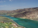
Ili River
Encyclopedia

River
A river is a natural watercourse, usually freshwater, flowing towards an ocean, a lake, a sea, or another river. In a few cases, a river simply flows into the ground or dries up completely before reaching another body of water. Small rivers may also be called by several other names, including...
in northwestern China
China
Chinese civilization may refer to:* China for more general discussion of the country.* Chinese culture* Greater China, the transnational community of ethnic Chinese.* History of China* Sinosphere, the area historically affected by Chinese culture...
(Ili Kazakh Autonomous Prefecture
Ili Kazakh Autonomous Prefecture
Ili Kazakh Autonomous Prefecture , in northernmost Xinjiang, is the only Kazakh autonomous prefecture of the People's Republic of China.-Geography and coordinates:The following figures excludes both Tacheng Prefecture and Altay Prefecture....
of the Xinjiang Uighur Autonomous Region
Xinjiang
Xinjiang is an autonomous region of the People's Republic of China. It is the largest Chinese administrative division and spans over 1.6 million km2...
) and southeastern Kazakhstan
Kazakhstan
Kazakhstan , officially the Republic of Kazakhstan, is a transcontinental country in Central Asia and Eastern Europe. Ranked as the ninth largest country in the world, it is also the world's largest landlocked country; its territory of is greater than Western Europe...
(the Almaty Province
Almaty Province
Almaty is a province of Kazakhstan. Its capital is Taldykorgan, which has a population of 118,400. The province itself has 1,603,700 people.-Geography:...
).
It is 1439 km (894.2 mi) long, 815 km (506.4 mi) of which is in Kazakhstan. It takes its beginning in eastern Tian Shan
Tian Shan
The Tian Shan , also spelled Tien Shan, is a large mountain system located in Central Asia. The highest peak in the Tian Shan is Victory Peak , ....
from the Tekes and Kunges (or Künes) rivers. The Ili River drains the basin between the Tian Shan the Borohoro (P'o-lo-k'o-nu) Mountains to the north.
Flowing into Lake Balkhash
Lake Balkhash
Lake Balkhash is one of the largest lakes in Asia and 12th largest continental lake in the world. It is located in southeastern Kazakhstan, in Central Asia, and belongs to an endorheic basin shared by Kazakhstan and China, with a small part in Kyrgyzstan. The basin drains into the lake via seven...
it forms a large delta
River delta
A delta is a landform that is formed at the mouth of a river where that river flows into an ocean, sea, estuary, lake, reservoir, flat arid area, or another river. Deltas are formed from the deposition of the sediment carried by the river as the flow leaves the mouth of the river...
with vast wetland regions of lakes, marshes and thicket vegetation.
Chinese region
The upper Ili Valley is separated from the Dzungarian BasinDzungaria
Dzungaria, also called Zungaria, is a geographical region in northwest China corresponding to the northern half of Xinjiang. It covers approximately , lying mostly within Xinjiang, and extending into western Mongolia and eastern Kazakhstan...
in the north by the Borohoro Mountains, and from the Tarim Basin
Tarim Basin
The Tarim Basin is a large endorheic basin occupying an area of about . It is located in the Xinjiang Uyghur Autonomous Region in China's far west. Its northern boundary is the Tian Shan mountain range and its southern is the Kunlun Mountains on the northern edge of the Tibetan Plateau. The...
in the south by the main range of the Tian Shan
Tian Shan
The Tian Shan , also spelled Tien Shan, is a large mountain system located in Central Asia. The highest peak in the Tian Shan is Victory Peak , ....
. This region was the stronghold of the Qing
Qing Dynasty
The Qing Dynasty was the last dynasty of China, ruling from 1644 to 1912 with a brief, abortive restoration in 1917. It was preceded by the Ming Dynasty and followed by the Republic of China....
administration in Xinjiang in the late 18th and 19th centuries;
it was occupied by Russia from 1871 to 1881, that is, from the Yaqub Beg rebellion until the Treaty of Saint Petersburg (1881)
Treaty of Saint Petersburg (1881)
The Treaty of Saint Petersburg , also known as Treaty of Ili, was the treaty between the Russian Empire and the Chinese Empire, signed in Saint Petersburg, Russia, on 12 February 1881...
.
Presently, the region forms part of Xinjiang's Ili Kazakh Autonomous Prefecture
Ili Kazakh Autonomous Prefecture
Ili Kazakh Autonomous Prefecture , in northernmost Xinjiang, is the only Kazakh autonomous prefecture of the People's Republic of China.-Geography and coordinates:The following figures excludes both Tacheng Prefecture and Altay Prefecture....
. The main city of the region, Yining (Kulja), is located on the northern side of the river some 100 km (62.1 mi) upstream from the international border. Until the early 1900s, the city was commonly known under the same name as the river, 伊犁 (Pinyin: Yili; Wade-Giles
Wade-Giles
Wade–Giles , sometimes abbreviated Wade, is a romanization system for the Mandarin Chinese language. It developed from a system produced by Thomas Wade during the mid-19th century , and was given completed form with Herbert Giles' Chinese–English dictionary of 1892.Wade–Giles was the most...
: Ili). On the southern side, even closer to the international border, Qapqal Xibe Autonomous County
Qapqal Xibe Autonomous County
Qapqal Xibe Autonomous County in Ili Kazakh Autonomous Prefecture in northern Xinjiang is the only Xibe autonomous county of the People's Republic of China. It has an area of 4,430 square kilometers and a population 160,000...
is located, which is home to many of the China's Xibe
Xibe
The Xibe or Sibo are a Tungusic ethnic group living mostly in northeast China and Xinjiang. They form one of the 56 ethnic groups officially recognized by the People's Republic of China.- History :...
people, who were resettled to this borderland in the 18th century as part of the Manchu garrison.
Kazakh region
The region of Kazakhstan drained by the Ili and its tributaries is known in Kazakh as Zhetysu ('Seven Rivers') and in Russian as Semirechye (meaning the same).The Kapshagay Hydroelectric Power Plant was constructed between 1965 and 1970 near Kapchagay in the middle reaches of the Ili River, forming the Kapchagay Reservoir
Kapchagay Reservoir
Kapchagay Reservoir, also spelled Qapshaghay Bogeni Reservoir and sometimes referred to as Lake Kapchagay, is a major reservoir in Almaty Province in southeastern Kazakhstan, approximately 60 kilometres north of Almaty. The 140 kilometre long lake is formed by a dam on the Ili River which flows...
—an artificial 110 km (68.4 mi) long lake north of Almaty
Almaty
Almaty , also known by its former names Verny and Alma-Ata , is the former capital of Kazakhstan and the nation's largest city, with a population of 1,348,500...
.
Tamgaly-Tas, some 20 km (12.4 mi) downstream along Ili River is the site of rock drawings. The name Tamgaly in Kazakh
Kazakh language
Kazakh is a Turkic language which belongs to the Kipchak branch of the Turkic languages, closely related to Nogai and Karakalpak....
means painted or marked place, Tas - stone.
Tributaries include
- Charyn RiverCharyn RiverThe Charyn River is a river in the Almaty Province of Kazakhstan. It flows into the Ili River, which is considered to be the largest artery of Lake Balkhash. The Charyn River is 427 km long. It runs through the territory of Kegen and Uigur regions, forming up the Charyn Canyon.The Moinak Hydro...
, famous for its canyonCharyn CanyonCharyn Canyon is an 80 km canyon in Kazakhstan on the Charyn River, 200 km east of Almaty, close to the Chinese border. It is part of the Charyn National Park, which is established 23 February 2004 and located within the territory of the Uyghur and Kegen Districts of the Almaty Province.It... - Kash River
Historical connections
The Ili River gave its name to the Ili River treatyIli river treaty
The Ili River Treaty was a treaty between the warring eastern and western parts of the Western Turkic Kaganate that concluded the civil war between warring parties...
of 638 AD, which formalized the division of the Western Turkic Kaganate (552-638 AD) into the Nushibi
Nushibi
Nushibi was a Chinese collective name for five tribes of the right wing in the Western Turkic Kaganate, and members of On oq confederation found in the literature about the Western Turkic Kaganate as Ten arrows Türks...
and the Dulu, and established the Ili River as the border between the two states.