
Indian Space Research Organisation
Encyclopedia
The Indian Space Research Organisation (ISRO, icon; ) is an independent Indian governmental
agency established in 1969 for the research and development
of vehicles and activities for the exploration of space
within and outside of Earth’s atmosphere. Headquartered in Bangalore
(Bengaluru). ISRO’s chief executive is a chairman, who is also chairman of the Indian government’s Space Commission and the secretary of the Department of Space
.
ISRO’s first satellite
, Aryabhata
, was launched by the Soviet Union
in 1975. Rohini, the first satellite to be placed in orbit by an Indian-made launch vehicle (the Satellite Launch Vehicle 3) was launched in 1980. ISRO subsequently developed two other rockets: the Polar Satellite Launch Vehicle for putting satellites into polar orbit
and the Geostationary Space Launch Vehicle for placing satellites into geostationary orbit
. These rockets have launched communications satellites, Earth-observation satellites, and, in 2008, Chandrayaan-1, India’s first mission to the Moon
. ISRO plans to put two astronauts into orbit in 2015.
Over the years, ISRO has conducted a variety of operations for both Indian and foreign clients. ISRO's satellite launch capability is mostly provided by indigenous launch vehicle
s and launch sites. In 2008, ISRO successfully launched its first lunar probe, Chandrayaan-1, while future plans include indigenous development of GSLV, manned space missions
, further lunar exploration, and interplanetary probes. ISRO has several field installations as assets, and cooperates with the international community as a part of several bilateral and multilateral agreements.
 Modern space research in India is most visibly traced to the activities of scientist S. K. Mitra
who conducted a series of experiments leading to the sounding of the ionosphere
by application of ground based radio
methods in 1920's Calcutta. Later, Indian scientists like C.V. Raman and Meghnad Saha
contributed to scientific principles applicable in space sciences. However, it was the period after 1945 which saw important developments being made in coordinated space research in India. Organized space research in India was spearheaded by two scientists: Vikram Sarabhai—founder of the Physical Research Laboratory
at Ahmedabad
—and Homi Bhabha, who had played a role in the establishment of the Tata Institute of Fundamental Research
in 1945. Initial experiments in space sciences included the study of cosmic radiation, high altitude and airborne testing of instruments, deep underground experimentation at the Kolar mines
—one of the deepest mining sites in the world — and studies of the upper atmosphere
. Studies were carried out at research laboratories, universities, and independent locations.
Government support became visible by 1950 when the Department of Atomic Energy
was founded with Homi Bhabha as secretary. The Department of Atomic Energy provided funding for space research throughout India. Tests on the Earth's magnetic field
—studied in India since the establishment of the observatory at Colaba
in 1823—and aspects of meteorology
continued to yield valuable information and in 1954, Uttar Pradesh
state observatory was established at the foothills of the Himalayas
. The Rangpur Observatory was set up in 1957 at Osmania University
, Hyderabad. Both these facilities enjoyed the technical support and scientific cooperation of the United States of America. Space research was further encouraged by the technically inclined prime minister of India
—Jawaharlal Nehru
. In 1957, the Soviet Union
successfully launched Sputnik and opened up possibilities for the rest of the world to conduct a space launch. The Indian National Committee for Space Research
(INCOSPAR) was found in 1962 with Vikram Sarabhai as its chairman.
, considered the father of Indian Space Programme. As stated by him:
As also pointed out by Dr APJ Kalam:
India's economic progress has made its space program more visible and active as the country aims for greater self-reliance in space technology. Hennock etc. hold that India also connects space exploration to national prestige, further stating: "This year India has launched 11 satellites, including nine from other countries—and it became the first nation to launch satellites on one rocket."
Indian Space Research Organisation (ISRO) has successfully operationalised two major satellite systems namely Indian National Satellites (INSAT) for communication services and Indian Remote Sensing (IRS) satellites for management of natural resources; also, Polar Satellite Launch Vehicle (PSLV) for launching IRS type of satellites and Geostationary Satellite Launch Vehicle (GSLV) for launching INSAT type of satellites.
 Geopolitical and economic considerations during the 1960s and 1970s compelled India to initiate its own launch vehicle
program. During the first phase (1960s-1970s) the country successfully developed a sounding rockets program, and by the 1980s, research had yielded the Satellite Launch Vehicle-3 and the more advanced Augmented Satellite Launch Vehicle (ASLV), complete with operational supporting infrastructure. ISRO further applied its energies to the advancement of launch vehicle technology resulting in the creation of Polar Satellite Launch Vehicle
(PSLV) and Geosynchronous Satellite Launch Vehicle
(GSLV) technologies.
The Satellite Launch Vehicle, usually known by its abbreviation SLV or SLV-3 was a 4-stage solid-fuel light launcher. It was intended to reach a height of 500 km and carry a payload of 40 kg. Its first launch took place in 1979 with 2 more in each subsequent year, and the final launch in 1983. Only two of its four test flights were successful.
The Augmented Satellite Launch Vehicle, usually known by its abbreviation ASLV was a 5-stage solid propellant rocket with the capability of placing a 150 kg satellite into LEO
. This project was started by the ISRO during the early 1980s to develop technologies needed for a payload to be placed into a geostationary orbit. Its design was based on Satellite Launch Vehicle. The first launch test was held in 1987, and after that 3 others followed in 1988, 1992 and 1994, out of which only 2 were successful, before it was decommissioned.
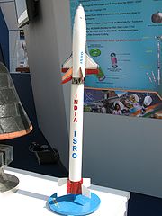
The Polar Satellite Launch Vehicle, usually known by its abbreviation PSLV, is an expendable launch system
developed to allow India
to launch its Indian Remote Sensing (IRS) satellites into sun synchronous orbits, a service that was, until the advent of the PSLV, commercially viable only from Russia
. PSLV can also launch small satellites into geostationary transfer orbit (GTO). The reliability and versatility of the PSLV is proven by the fact that it has launched 30 spacecraft (14 Indian and 16 from other countries) into a variety of orbits so far. In April 2008, it successfully launched 10 satellites at once, breaking a world record held by Russia.
On 15 July 2011 PSLV flight for 19 times with the first maiden voyage was failure in September 1993. So, with 18th successive mission to put satellites, PSLV trusted as rocket with 94 percent success.
The Geosynchronous Satellite Launch Vehicle, usually known by its abbreviation GSLV, is an expendable launch system developed to enable India to launch its INSAT
-type satellites into geostationary orbit and to make India less dependent on foreign rockets. At present, it is ISRO's heaviest satellite launch vehicle and is capable of putting a total payload of up to 5 tons to Low Earth Orbit. The vehicle is built by India with the cryogenic engine purchased from Russia while the ISRO develops its own engine program.
In a setback for ISRO, the latest attempt to launch the GSLV, GSLV-F06 carrying GSAT-5P, failed on 25 December 2010. The initial evaluation implies that loss of control for the strap-on boosters caused the rocket to veer from its intended flight path, forcing a programmed detonation. Sixty-four seconds into the first stage of flight, the rocket began to break up due to the acute angle of attack. The body housing the 3rd stage, the cryogenic stage, incurred structural damage, forcing the range safety team to initiate a programmed detonation of the rocket.
The Geosynchronous Satellite Launch Vehicle Mark-III is a launch vehicle currently under development by the Indian Space Research Organization. It is intended to launch heavy satellites into geostationary orbit
, and will allow India
to become less dependent on foreign rockets for heavy lifting. The rocket is the technological successor to the GSLV, however is not derived from its predecessor. The maiden flight is scheduled to take place in 2012.
 India's first satellite, the Aryabhata
, was launched by the Ariane Rocket as a part of APPLE Experiment from Kourou in 1975. This was followed by the Rohini series of experimental satellites which were built and launched indigenously. At present, ISRO operates a large number of earth observation satellites.
, All India Radio
and Doordarshan
. The overall coordination and management of INSAT system rests with the Secretary-level INSAT Coordination Committee.
and provide data in a variety of spatial, spectral and temporal resolutions to enable several programs to be undertaken relevant to national development. The initial versions are composed of the 1 (A,B,C,D) nomenclature. The later versions are named based on their area of application including OceanSat, CartoSat, ResourceSat.
series. Kalpana-1
, ISRO's first dedicated meteorological satellite, was launched by the Polar Satellite Launch Vehicle
on 12 September 2002. The satellite was originally known as MetSat-1. In February 2003 it was renamed to Kalpana-1 by the then Indian Prime Minister Atal Bihari Vajpayee in memory of Kalpana Chawla
– a NASA astronaut of Indian origin who perished in Space Shuttle Columbia
.
and unmanned missions to Mars
and Near-Earth object
s such as asteroids and comets.
. India launched the spacecraft using a modified version of the PSLV is C11 on 22 October 2008 from Satish Dhawan Space Centre
, Sriharikota. The vehicle was successfully inserted into lunar orbit on 8 November 2008. It carries high-resolution remote sensing equipment for visible, near infrared, and soft and hard X-ray frequencies. Over its two-year operational period, it is intended to survey the lunar surface to produce a complete map of its chemical characteristics and 3-dimensional topography. The polar regions are of special interest, as they might contain ice
. The lunar mission carries five ISRO payloads and six payloads from other international space agencies including NASA
, ESA, and the Bulgarian Aerospace Agency
, which were carried free of cost. The Chandrayaan-1 became the first lunar mission to discover existence of water on the moon.
(GSLV) to put the satellite in orbit and was considering using ion-thrusters, liquid engines or nuclear power
to propel it further towards Mars. The Mars mission studies had already been completed and that space scientists were trying to collect scientific proposals and scientific objectives.
The Indian Space Research Organization has been sanctioned a budget of for its human spaceflight program. According to the Space Commission which passed the budget, an unmanned flight will be launched in 2013 and manned mission will launch in 2016. If realized in the stated time-frame, India will become the fourth nation, after the USSR
, USA
and China
, to successfully carry out manned missions indigenously.
(SCRE or more commonly SRE or SRE-1) is an experimental Indian spacecraft which was launched using the PSLV C7 rocket, along with three other satellites. It remained in orbit for 12 days before re-entering the Earth's atmosphere and splashing down into the Bay of Bengal.
The SRE-1 was designed to demonstrate the capability to recover an orbiting space capsule, and the technology for performing experiments in the microgravity conditions of an orbiting platform. It was also intended to test thermal protection, navigation, guidance, control, deceleration and flotation systems, as well as study hypersonic aero-thermodynamics, management of communication blackouts, and recovery operations.
ISRO also plans to launch SRE-2 and SRE-3 in the near future to test advanced re-entry technology for future manned missions.
by 2012 to prepare personnel for flights on board the crewed vehicle. The centre will use water simulation to train the selected astronauts in rescue and recovery operations and survival in zero gravity, and will undertake studies of the radiation environment of space.
ISRO will build centrifuges
to prepare astronauts for the acceleration phase of the mission. It also plans to build a new Launch pad to meet the target of launching a manned space mission by 2015. This would be the third launchpad at the Satish Dhawan Space Centre
, Sriharikota.
intend to be the basis of indigenous Indian human spaceflight program.
The capsule will be designed to carry three people, and a planned upgraded version will be equipped with a rendezvous and docking capability. In its maiden manned mission, ISRO's largely autonomous 3-ton capsule will orbit the Earth at 248 miles (400 km) in altitude for up to seven days with a two-person crew on board. The crew vehicle would launch atop of ISRO's GSLV Mk II, currently under development. The GSLV Mk II features an indigenously developed cryogenic upper-stage engine. The first test of the cryogenic engine, held on 15 April 2010, failed as the cryogenic phase did not perform as expected and rocket deviated from the planned trajectory. A future launch has been scheduled for 2011. If successful then ISRO will become the sixth entity, after United States
, Russia
, China
, Japan
and Europe
, to develop this technology.
in 1963. Even before this, noteworthy contributions were made by the Indian scientists in the following areas of space science research:
With the advent of the Indian space program, emphasis was laid on indigenous, self-reliant and state-of-the-art development of technology for immediate practical applications in the fields of space science research activities in the country.
There is a national balloon launching facility at Hyderabad jointly supported by TIFR and ISRO. This facility has been extensively used for carrying out research in high energy (i.e., X- and gamma ray) astronomy, IR astronomy, middle atmospheric trace constituents including CFCs & aerosols, ionisation, electric conductivity and electric fields.
The flux of secondary particles and X-ray
and gamma-rays of atmospheric origin produced by the interaction of the cosmic rays is very low. This low background, in the presence of which one has to detect the feeble signal from cosmic sources is a major advantage in conducting hard X-ray observations from India. The second advantage is that many bright sources like Cyg X-1, Crab Nebula
, Scorpius X-1
and Galactic Centre sources are observable from Hyderabad due to their favourable declination. With these considerations, an X-ray astronomy
group was formed at TIFR in 1967 and development of an instrument with an orientable X-ray telescope
for hard X-ray observations was undertaken. The first balloon flight with the new instrument was made on 28 April 1968 in which observations of Scorpius X-1 were successfully carried out. In a succession of balloon flights made with this instrument between 1968 and 1974 a number of binary X-ray sources including Scorpius X-1, Cyg X-1
, Her X-1 etc. and the diffuse cosmic X-ray background were studied. Many new and astrophysically important results were obtained from these observations.
One of most important achievements of ISRO in this field was the discovery of three species of bacteria in the upper stratosphere at an altitude of between 20–40 km. The bacteria, highly resistant to ultra-violet radiation, are not found elsewhere on Earth, leading to speculation on whether they are extraterrestrial in origin. These three bacteria can be considered to be extremophile
s. Until then, the upper stratosphere was believed to be inhospitable because of the high doses of ultra-violet radiation. The bacteria were named as Bacillus isronensis in recognition of ISRO's contribution in the balloon experiments, which led to its discovery, Bacillus aryabhata after India's celebrated ancient astronomer Aryabhata
and Janibacter Hoylei after the distinguished astrophysicist Fred Hoyle
.
Other facilities include:
 ISRO plans to launch a number of new-generation Earth Observation Satellites in the near future. It will also undertake the development of new launch vehicles and spacecraft. ISRO has stated that it will send unmanned missions to Mars and Near-Earth Objects.
Forthcoming Satellites
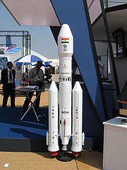
GSLV-Mk III is envisaged to launch four tonne satellite into geosynchronous transfer orbit. GSLV-Mk III is a three-stage vehicle with a 110 tonne core liquid propellant stage (L-110) and a strap-on stage with two solid propellant motors, each with 200 tonne propellant (S-200). The upper stage will be cryogenic with a propellant loading of 25 tonne (C-25). GSLV Mk-III will have a lift-off weight of about 626 tonne and will be 43.43 m tall. The payload fairing will have a diameter of 5 metre and a payload volume of 100 cubic metre. GSLV Mk III is planned to be launched during 2013.
Reusable Launch Vehicle-Technology Demonstrator (RLV-TD)
As a first step towards realizing a Two Stage To Orbit (TSTO) fully re-usable launch vehicle, a series of technology demonstration missions have been conceived. For this purpose a Winged Reusable Launch Vehicle technology Demonstrator (RLV-TD) has been configured. The RLV-TD will act as a flying test bed to evaluate various technologies viz., hypersonic flight, autonomous landing, powered cruise flight and hypersonic flight using air-breathing propulsion. First in the series of demonstration trials is the hypersonic flight experiment (HEX).
Human Space Flight Mission Programme
Following the success of Chandrayaan-1, the country's first moon mission, ISRO is planning a series of further lunar missions in the next decade, including a manned mission which is stated to take place in 2020 – approximately the same time as the China National Space Administration
(CNSA) manned lunar mission and NASA
's Project Constellation
plans to return to the moon with its Orion-Altair project.
Mars exploration program
Solar exploration program
The main objective of SRE II is to realize a fully recoverable capsule and provide a platform to conduct microgravity experiments on Micro-biology, Agriculture, Powder Metallurgy, etc. SRE-2 is proposed to be launched on board PSLV.
Aditya (spacecraft)
The First Indian space based Solar Coronagraph to study solar Corona in visible and near IR bands. Launch of the Aditya mission is planned during the next high solar activity period ~ 2012. The main objectives is to study the Coronal Mass Ejection (CME) and consequently the crucial physical parameters for space weather such as the coronal magnetic field structures, evolution of the coronal magnetic field etc. This will provide completely new information on the velocity fields and their variability in the inner corona having an important bearing on the unsolved problem of heating of the corona would be obtained.
The Ministry of Civil Aviation has decided to implement an indigenous Satellite-Based Regional GPS Augmentation System also known as Space-Based Augmentation System (SBAS) as part of the Satellite-Based Communications, Navigation and Surveillance (CNS)/Air Traffic Management (ATM) plan for civil aviation. The Indian SBAS system has been given an acronym GAGAN - GPS Aided GEO Augmented Navigation. A national plan for satellite navigation including implementation of Technology Demonstration System (TDS) over the Indian air space as a proof of concept has been prepared jointly by Airports Authority of India (AAI) and ISRO. TDS was successfully completed during 2007 by installing eight Indian Reference Stations (INRESs) at eight Indian airports and linked to the Master Control Center (MCC) located near Bangalore.
The first GAGAN navigation payload has been fabricated and it was proposed to be flown on GSAT-4 during Apr 2010. However, GSAT-4 was not placed in orbit as GSLV-D3 could not complete the mission. Two more GAGAN payloads will be subsequently flown, one each on two geostationary satellites, GSAT-8 and GSAT-10.
IRNSS
The Indian Regional Navigational Satellite System (IRNSS) is an autonomous regional satellite navigation system being developed by Indian Space Research Organisation which would be under total control of Indian government. The requirement of such a navigation system is driven by the fact that access to Global Navigation Satellite Systems like GPS are not guaranteed in hostile situations. ISRO plans to launch the constellation of satellites between 2010 and 2012.
(NICNET) are direct beneficiaries of applied satellite technology. Dinshaw Mistry—on the subject of practical applications of the Indian space program—writes:
The INSAT-2 satellites also provide telephone links to remote areas; data transmission for organizations such as the National Stock Exchange
; mobile satellite service communications for private operators, railways, and road transport; and broadcast satellite services, used by India’s state-owned television agency as well as commercial television channels. India’s EDUSAT (Educational Satellite), launched aboard the GSLV in 2004, was intended for adult literacy and distance learning applications in rural areas. It augmented and would eventually replace such capabilities already provided by INSAT-3B.
The IRS satellites have found applications with the Indian Natural Resource Management program, with regional Remote Sensing Service Centers in five Indian cities, and with Remote Sensing Application Centers in twenty Indian states that use IRS images for economic development applications. These include environmental monitoring, analyzing soil erosion and the impact of soil conservation measures, forestry management, determining land cover for wildlife sanctuaries, delineating groundwater potential zones, flood inundation mapping, drought monitoring, estimating crop acreage and deriving agricultural production estimates, fisheries monitoring, mining and geological applications such as surveying metal and mineral deposits, and urban planning.
India’s satellites and satellite launch vehicles have had military spin-offs. While India’s 93–124 mile (150–250 km) range Prithvi missile
is not derived from the Indian space program, the intermediate range Agni missile is drawn from the Indian space program’s SLV-3. In its early years, when headed by Vikram Sarabhai and Satish Dhawan, ISRO opposed military applications for its dual-use projects such as the SLV-3. Eventually, however, the Defence Research and Development (DRDO)–based missile program borrowed human resources and technology from ISRO. Missile scientist A. P. J. Abdul Kalam (elected president of India in 2002), who had headed the SLV-3 project at ISRO, moved to DRDO to direct India’s missile program. About a dozen scientists accompanied Abdul Kalam from ISRO to DRDO, where Abdul Kalam designed the Agni missile using the SLV-3’s solidfuel first stage and a liquid-fuel (Prithvi-missile-derived) second stage. The IRS and INSAT satellites were primarily intended and used for civilian-economic applications, but they also offered military spin-offs. In 1996 New Delhi
’s Ministry of Defence temporarily blocked the use of IRS-1C by India’s environmental and agricultural ministries in order to monitor ballistic missiles near India’s borders. In 1997 the Indian air force
’s “Airpower Doctrine” aspired to use space assets for surveillance and battle management.
Institutions like the Indira Gandhi National Open University
(IGNOU) and the Indian Institute of Technology use satellites for scholarly applications. Between 1975 and 1976, India conducted its largest sociological program using space technology, reaching 2400 villages through video programming in local languages aimed at educational development via ATS-6
technology developed by NASA. This experiment—named Satellite Instructional Television Experiment
(SITE)—conducted large scale video broadcasts resulting in significant improvement in rural education.
ISRO has applied its technology to "telemedicine", directly connecting patients in rural areas to medical professionals in urban locations via satellites. Since high-quality healthcare is not universally available in some of the remote areas of India, the patients in remote areas are diagnosed and analyzed by doctors in urban centres in real time via video conferencing. The patient is then advised medicine and treatment. The patient is then treated by the staff at one of the 'super-specialty hospitals' under instructions from the doctor. Mobile telemedicine vans are also deployed to visit locations in far-flung areas and provide diagnosis and support to patients.
ISRO has also helped implement India's Biodiversity Information System, completed in October 2002. Nirupa Sen details the program: "Based on intensive field sampling and mapping using satellite remote sensing and geospatial modelling tools, maps have been made of vegetation cover on a 1 : 250,000 scale. This has been put together in a web-enabled database which links gene-level information of plant species with spatial information in a BIOSPEC database of the ecological hot spot regions, namely northeastern India
, Western Ghats
, Western Himalayas
and Andaman and Nicobar Islands. This has been made possible with collaboration between the Department of Biotechnology and ISRO."
The Indian IRS-P5 (CARTOSAT-1
) was equipped with high-resolution panchromatic equipment to enable it for cartographic purposes. IRS-P5 (CARTOSAT-1) was followed by a more advanced model named IRS-P6 developed also for agricultural applications. The CARTOSAT-2
project, equipped with single panchromatic camera which supported scene-specific on-spot images, succeed the CARTOSAT-1 project.
ISRO and the Department of Space have signed formal Memorandum of Understanding
agreements with a number of foreign political entities, including:-
European Union
India carries out joint operations with foreign space agencies, such as the Indo-French Megha-Tropiques Mission
. On 25 June 2002 India and the European Union agreed to bilateral cooperation in the field of science and technology. A joint EU-India group of scholars was formed on 23 November 2001 to further promote joint research and development. India holds observer status at CERN
while a joint India-EU Software Education and Development Center is due at Bangalore
.
Government of India
The Government of India, officially known as the Union Government, and also known as the Central Government, was established by the Constitution of India, and is the governing authority of the union of 28 states and seven union territories, collectively called the Republic of India...
agency established in 1969 for the research and development
Research and development
The phrase research and development , according to the Organization for Economic Co-operation and Development, refers to "creative work undertaken on a systematic basis in order to increase the stock of knowledge, including knowledge of man, culture and society, and the use of this stock of...
of vehicles and activities for the exploration of space
Space exploration
Space exploration is the use of space technology to explore outer space. Physical exploration of space is conducted both by human spaceflights and by robotic spacecraft....
within and outside of Earth’s atmosphere. Headquartered in Bangalore
Bangalore
Bengaluru , formerly called Bengaluru is the capital of the Indian state of Karnataka. Bangalore is nicknamed the Garden City and was once called a pensioner's paradise. Located on the Deccan Plateau in the south-eastern part of Karnataka, Bangalore is India's third most populous city and...
(Bengaluru). ISRO’s chief executive is a chairman, who is also chairman of the Indian government’s Space Commission and the secretary of the Department of Space
Department of Space
The Department of Space is an Indian government department responsible for administration of the Indian space program.The Indian Space Research Organization is the primary research and development arm of the DoS...
.
ISRO’s first satellite
Satellite
In the context of spaceflight, a satellite is an object which has been placed into orbit by human endeavour. Such objects are sometimes called artificial satellites to distinguish them from natural satellites such as the Moon....
, Aryabhata
Aryabhata (satellite)
Aryabhatta was India's first satellite, named after the great Indian astronomer of the same name. It was launched by the Soviet Union on 19 April 1975 from Kapustin Yar using a Cosmos-3M launch vehicle. It was built by the Indian Space Research Organization to gain experience in building and...
, was launched by the Soviet Union
Soviet Union
The Soviet Union , officially the Union of Soviet Socialist Republics , was a constitutionally socialist state that existed in Eurasia between 1922 and 1991....
in 1975. Rohini, the first satellite to be placed in orbit by an Indian-made launch vehicle (the Satellite Launch Vehicle 3) was launched in 1980. ISRO subsequently developed two other rockets: the Polar Satellite Launch Vehicle for putting satellites into polar orbit
Polar orbit
A polar orbit is an orbit in which a satellite passes above or nearly above both poles of the body being orbited on each revolution. It therefore has an inclination of 90 degrees to the equator...
and the Geostationary Space Launch Vehicle for placing satellites into geostationary orbit
Geostationary orbit
A geostationary orbit is a geosynchronous orbit directly above the Earth's equator , with a period equal to the Earth's rotational period and an orbital eccentricity of approximately zero. An object in a geostationary orbit appears motionless, at a fixed position in the sky, to ground observers...
. These rockets have launched communications satellites, Earth-observation satellites, and, in 2008, Chandrayaan-1, India’s first mission to the Moon
Moon
The Moon is Earth's only known natural satellite,There are a number of near-Earth asteroids including 3753 Cruithne that are co-orbital with Earth: their orbits bring them close to Earth for periods of time but then alter in the long term . These are quasi-satellites and not true moons. For more...
. ISRO plans to put two astronauts into orbit in 2015.
Over the years, ISRO has conducted a variety of operations for both Indian and foreign clients. ISRO's satellite launch capability is mostly provided by indigenous launch vehicle
Launch vehicle
In spaceflight, a launch vehicle or carrier rocket is a rocket used to carry a payload from the Earth's surface into outer space. A launch system includes the launch vehicle, the launch pad and other infrastructure....
s and launch sites. In 2008, ISRO successfully launched its first lunar probe, Chandrayaan-1, while future plans include indigenous development of GSLV, manned space missions
Indian human spaceflight program
The Indian human spaceflight program is a proposal by the Indian Space Research Organisation to develop and launch the ISRO Orbital Vehicle, which is to carry a two-member crew to Low Earth Orbit by 2016. The spaceship would be launched by India's GSLV-Mk II launcher.- Preparations :On August 9,...
, further lunar exploration, and interplanetary probes. ISRO has several field installations as assets, and cooperates with the international community as a part of several bilateral and multilateral agreements.
Formative years
Sisir Kumar Mitra
Sisir Kumar Mitra [or Shishirkumar Mitra] was an Indian physicist.He was born and raised in Calcutta. His parents were the doctor Saratkumari and the school teacher Jaykrishna. At the age of nine he witnessed a hot air balloon and became intrigued in the phenomenon, so he began studying science...
who conducted a series of experiments leading to the sounding of the ionosphere
Ionosphere
The ionosphere is a part of the upper atmosphere, comprising portions of the mesosphere, thermosphere and exosphere, distinguished because it is ionized by solar radiation. It plays an important part in atmospheric electricity and forms the inner edge of the magnetosphere...
by application of ground based radio
Radio
Radio is the transmission of signals through free space by modulation of electromagnetic waves with frequencies below those of visible light. Electromagnetic radiation travels by means of oscillating electromagnetic fields that pass through the air and the vacuum of space...
methods in 1920's Calcutta. Later, Indian scientists like C.V. Raman and Meghnad Saha
Meghnad Saha
Meghnad Saha FRS was an Indian astrophysicist best known for his development of the Saha equation, used to describe chemical and physical conditions in stars.-Early life:...
contributed to scientific principles applicable in space sciences. However, it was the period after 1945 which saw important developments being made in coordinated space research in India. Organized space research in India was spearheaded by two scientists: Vikram Sarabhai—founder of the Physical Research Laboratory
Physical Research Laboratory
The Physical Research Laboratory is a national Research Institute for space and allied sciences, supported mainly by Department of Space, Government of India. This research laboratory has ongoing research programmes in Astronomy and Astrophysics, Atmospheric Sciences and Aeronomy, Earth Sciences,...
at Ahmedabad
Ahmedabad
Ahmedabad also known as Karnavati is the largest city in Gujarat, India. It is the former capital of Gujarat and is also the judicial capital of Gujarat as the Gujarat High Court has its seat in Ahmedabad...
—and Homi Bhabha, who had played a role in the establishment of the Tata Institute of Fundamental Research
Tata Institute of Fundamental Research
The Tata Institute of Fundamental Research is a research institution in India dedicated to basic research in mathematics and the sciences. It is a Deemed University and works under the umbrella of the Department of Atomic Energy of the Government of India. It is located at Navy Nagar, Colaba, Mumbai...
in 1945. Initial experiments in space sciences included the study of cosmic radiation, high altitude and airborne testing of instruments, deep underground experimentation at the Kolar mines
Particle experiments at Kolar Gold Fields
The Kolar Gold Fields , located in the Kolar district of the state of Karnataka, India, are a set of defunct gold mines known for the neutrino particle experiments and observations that took place here starting in 1960...
—one of the deepest mining sites in the world — and studies of the upper atmosphere
Earth's atmosphere
The atmosphere of Earth is a layer of gases surrounding the planet Earth that is retained by Earth's gravity. The atmosphere protects life on Earth by absorbing ultraviolet solar radiation, warming the surface through heat retention , and reducing temperature extremes between day and night...
. Studies were carried out at research laboratories, universities, and independent locations.
Government support became visible by 1950 when the Department of Atomic Energy
Department of Atomic Energy (India)
The Department of Atomic Energy is a department directly under the Prime Minister of India with headquartered in Mumbai. The department is responsible for nuclear technology, including nuclear power and research....
was founded with Homi Bhabha as secretary. The Department of Atomic Energy provided funding for space research throughout India. Tests on the Earth's magnetic field
Earth's magnetic field
Earth's magnetic field is the magnetic field that extends from the Earth's inner core to where it meets the solar wind, a stream of energetic particles emanating from the Sun...
—studied in India since the establishment of the observatory at Colaba
Colaba
Colaba is a part of the city of Mumbai, India, and also a Lok Sabha constituency. During Portuguese rule in the 16th century, the island was known as Candil...
in 1823—and aspects of meteorology
Meteorology
Meteorology is the interdisciplinary scientific study of the atmosphere. Studies in the field stretch back millennia, though significant progress in meteorology did not occur until the 18th century. The 19th century saw breakthroughs occur after observing networks developed across several countries...
continued to yield valuable information and in 1954, Uttar Pradesh
Uttar Pradesh
Uttar Pradesh abbreviation U.P. , is a state located in the northern part of India. With a population of over 200 million people, it is India's most populous state, as well as the world's most populous sub-national entity...
state observatory was established at the foothills of the Himalayas
Himalayas
The Himalaya Range or Himalaya Mountains Sanskrit: Devanagari: हिमालय, literally "abode of snow"), usually called the Himalayas or Himalaya for short, is a mountain range in Asia, separating the Indian subcontinent from the Tibetan Plateau...
. The Rangpur Observatory was set up in 1957 at Osmania University
Osmania University
Osmania University , , since 1918, is a public university located in Hyderabad, Andhra Pradesh, India. It was established and named after the last Nizam of Hyderabad, Mir Osman Ali Khan. It is one of the oldest modern universities in India. It is the first Indian University to have Urdu and...
, Hyderabad. Both these facilities enjoyed the technical support and scientific cooperation of the United States of America. Space research was further encouraged by the technically inclined prime minister of India
Prime Minister of India
The Prime Minister of India , as addressed to in the Constitution of India — Prime Minister for the Union, is the chief of government, head of the Council of Ministers and the leader of the majority party in parliament...
—Jawaharlal Nehru
Jawaharlal Nehru
Jawaharlal Nehru , often referred to with the epithet of Panditji, was an Indian statesman who became the first Prime Minister of independent India and became noted for his “neutralist” policies in foreign affairs. He was also one of the principal leaders of India’s independence movement in the...
. In 1957, the Soviet Union
Soviet Union
The Soviet Union , officially the Union of Soviet Socialist Republics , was a constitutionally socialist state that existed in Eurasia between 1922 and 1991....
successfully launched Sputnik and opened up possibilities for the rest of the world to conduct a space launch. The Indian National Committee for Space Research
Indian National Committee for Space Research
The Indian National Committee for Space Research was set up in 1962 by the Indian Government under Dr. Vikram Sarabhai to formulate the Indian Space Program. At the time, the committee was part of the Tata Institute of Fundamental Research, led by M. G. K. Menon. The committee took over the...
(INCOSPAR) was found in 1962 with Vikram Sarabhai as its chairman.
Goals and objectives
The prime objective of ISRO is to develop space technology and its application to various national tasks. The Indian space program was driven by the vision of Dr Vikram SarabhaiVikram Sarabhai
Vikram Ambalal Sarabhai was an Indian physicist. He is considered to be the father of the Indian space program; legendary Homi Bhabha’s successor as chairman of the Atomic Energy Commission; and was as at home in the world of the arts as in his favourite laboratory. His interests were vast and...
, considered the father of Indian Space Programme. As stated by him:
As also pointed out by Dr APJ Kalam:
India's economic progress has made its space program more visible and active as the country aims for greater self-reliance in space technology. Hennock etc. hold that India also connects space exploration to national prestige, further stating: "This year India has launched 11 satellites, including nine from other countries—and it became the first nation to launch satellites on one rocket."
Indian Space Research Organisation (ISRO) has successfully operationalised two major satellite systems namely Indian National Satellites (INSAT) for communication services and Indian Remote Sensing (IRS) satellites for management of natural resources; also, Polar Satellite Launch Vehicle (PSLV) for launching IRS type of satellites and Geostationary Satellite Launch Vehicle (GSLV) for launching INSAT type of satellites.
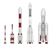
Launch vehicle fleet
Launch vehicle
In spaceflight, a launch vehicle or carrier rocket is a rocket used to carry a payload from the Earth's surface into outer space. A launch system includes the launch vehicle, the launch pad and other infrastructure....
program. During the first phase (1960s-1970s) the country successfully developed a sounding rockets program, and by the 1980s, research had yielded the Satellite Launch Vehicle-3 and the more advanced Augmented Satellite Launch Vehicle (ASLV), complete with operational supporting infrastructure. ISRO further applied its energies to the advancement of launch vehicle technology resulting in the creation of Polar Satellite Launch Vehicle
Polar Satellite Launch Vehicle
The Polar Satellite Launch Vehicle , commonly known by its abbreviation PSLV, is an expendable launch system developed and operated by the Indian Space Research Organisation . It was developed to allow India to launch its Indian Remote Sensing satellites into sun synchronous orbits, a service that...
(PSLV) and Geosynchronous Satellite Launch Vehicle
Geosynchronous Satellite Launch Vehicle
The Geosynchronous Satellite Launch Vehicle is an expendable launch system operated by the Indian Space Research Organisation...
(GSLV) technologies.
Satellite Launch Vehicle (SLV)
-
- Status: Decommissioned
The Satellite Launch Vehicle, usually known by its abbreviation SLV or SLV-3 was a 4-stage solid-fuel light launcher. It was intended to reach a height of 500 km and carry a payload of 40 kg. Its first launch took place in 1979 with 2 more in each subsequent year, and the final launch in 1983. Only two of its four test flights were successful.
Augmented Satellite Launch Vehicle (ASLV)
-
- Status: Decommissioned
The Augmented Satellite Launch Vehicle, usually known by its abbreviation ASLV was a 5-stage solid propellant rocket with the capability of placing a 150 kg satellite into LEO
Low Earth orbit
A low Earth orbit is generally defined as an orbit within the locus extending from the Earth’s surface up to an altitude of 2,000 km...
. This project was started by the ISRO during the early 1980s to develop technologies needed for a payload to be placed into a geostationary orbit. Its design was based on Satellite Launch Vehicle. The first launch test was held in 1987, and after that 3 others followed in 1988, 1992 and 1994, out of which only 2 were successful, before it was decommissioned.
Polar Satellite Launch Vehicle (PSLV)
-
- Status: Active
The Polar Satellite Launch Vehicle, usually known by its abbreviation PSLV, is an expendable launch system
Expendable launch system
An expendable launch system is a launch system that uses an expendable launch vehicle to carry a payload into space. The vehicles used in expendable launch systems are designed to be used only once , and their components are not recovered for re-use after launch...
developed to allow India
India
India , officially the Republic of India , is a country in South Asia. It is the seventh-largest country by geographical area, the second-most populous country with over 1.2 billion people, and the most populous democracy in the world...
to launch its Indian Remote Sensing (IRS) satellites into sun synchronous orbits, a service that was, until the advent of the PSLV, commercially viable only from Russia
Russia
Russia or , officially known as both Russia and the Russian Federation , is a country in northern Eurasia. It is a federal semi-presidential republic, comprising 83 federal subjects...
. PSLV can also launch small satellites into geostationary transfer orbit (GTO). The reliability and versatility of the PSLV is proven by the fact that it has launched 30 spacecraft (14 Indian and 16 from other countries) into a variety of orbits so far. In April 2008, it successfully launched 10 satellites at once, breaking a world record held by Russia.
On 15 July 2011 PSLV flight for 19 times with the first maiden voyage was failure in September 1993. So, with 18th successive mission to put satellites, PSLV trusted as rocket with 94 percent success.
Geosynchronous Satellite Launch Vehicle (GSLV)
-
- Status: Active
The Geosynchronous Satellite Launch Vehicle, usually known by its abbreviation GSLV, is an expendable launch system developed to enable India to launch its INSAT
Indian National Satellite System
INSAT or the Indian National Satellite System is a series of multipurpose Geo-stationary satellites launched by ISRO to satisfy the telecommunications, broadcasting, meteorology, and search and rescue operations....
-type satellites into geostationary orbit and to make India less dependent on foreign rockets. At present, it is ISRO's heaviest satellite launch vehicle and is capable of putting a total payload of up to 5 tons to Low Earth Orbit. The vehicle is built by India with the cryogenic engine purchased from Russia while the ISRO develops its own engine program.
In a setback for ISRO, the latest attempt to launch the GSLV, GSLV-F06 carrying GSAT-5P, failed on 25 December 2010. The initial evaluation implies that loss of control for the strap-on boosters caused the rocket to veer from its intended flight path, forcing a programmed detonation. Sixty-four seconds into the first stage of flight, the rocket began to break up due to the acute angle of attack. The body housing the 3rd stage, the cryogenic stage, incurred structural damage, forcing the range safety team to initiate a programmed detonation of the rocket.
Geosynchronous Satellite Launch Vehicle Mark-III (GSLV III)
-
- Status: In Development
The Geosynchronous Satellite Launch Vehicle Mark-III is a launch vehicle currently under development by the Indian Space Research Organization. It is intended to launch heavy satellites into geostationary orbit
Geostationary orbit
A geostationary orbit is a geosynchronous orbit directly above the Earth's equator , with a period equal to the Earth's rotational period and an orbital eccentricity of approximately zero. An object in a geostationary orbit appears motionless, at a fixed position in the sky, to ground observers...
, and will allow India
India
India , officially the Republic of India , is a country in South Asia. It is the seventh-largest country by geographical area, the second-most populous country with over 1.2 billion people, and the most populous democracy in the world...
to become less dependent on foreign rockets for heavy lifting. The rocket is the technological successor to the GSLV, however is not derived from its predecessor. The maiden flight is scheduled to take place in 2012.
Earth observation and communication satellites
Aryabhata (satellite)
Aryabhatta was India's first satellite, named after the great Indian astronomer of the same name. It was launched by the Soviet Union on 19 April 1975 from Kapustin Yar using a Cosmos-3M launch vehicle. It was built by the Indian Space Research Organization to gain experience in building and...
, was launched by the Ariane Rocket as a part of APPLE Experiment from Kourou in 1975. This was followed by the Rohini series of experimental satellites which were built and launched indigenously. At present, ISRO operates a large number of earth observation satellites.
The INSAT series
INSAT (Indian National Satellite System) is a series of multipurpose geostationary satellites launched by ISRO to satisfy the telecommunications, broadcasting, meteorology and search-and-rescue needs of India. Commissioned in 1983, INSAT is the largest domestic communication system in the Asia-Pacific Region. It is a joint venture of the Department of Space, Department of Telecommunications, India Meteorological DepartmentIndia Meteorological Department
The India Meteorological Department , also referred to as the Met Office, is an agency of the Ministry of Earth Sciences of the Government of India. It is the principal agency responsible for meteorological observations, weather forecasting and seismology...
, All India Radio
All India Radio
All India Radio , officially known since 1956 as Akashvani , is the radio broadcaster of India and a division of Prasar Bharati. Established in 1936, it is the sister service of Prasar Bharati's Doordarshan, the national television broadcaster. All India Radio is one of the largest radio networks...
and Doordarshan
DoorDarshan
Doordarshan is an Indian public service broadcaster, a division of Prasar Bharati. It is one of the largest broadcasting organizations in India in terms of the infrastructure of studios and transmitters. Recently, it has also started Digital Terrestrial Transmitters. On September 15, 2009,...
. The overall coordination and management of INSAT system rests with the Secretary-level INSAT Coordination Committee.
The IRS series
Indian Remote Sensing satellites (IRS) are a series of earth observation satellites, built, launched and maintained by ISRO. The IRS series provides remote sensing services to the country. The Indian Remote Sensing Satellite system is the largest constellation of remote sensing satellites for civilian use in operation today in the world. All the satellites are placed in polar sun-synchronous orbitSun-synchronous orbit
A Sun-synchronous orbit is a geocentric orbit which combines altitude and inclination in such a way that an object on that orbit ascends or descends over any given point of the Earth's surface at the same local mean solar time. The surface illumination angle will be nearly the same every time...
and provide data in a variety of spatial, spectral and temporal resolutions to enable several programs to be undertaken relevant to national development. The initial versions are composed of the 1 (A,B,C,D) nomenclature. The later versions are named based on their area of application including OceanSat, CartoSat, ResourceSat.
Other satellites
ISRO has also launched a set of experimental geostationary satellites known as the GSATGSAT
The GSAT satellites are India's indigenously developed technologies of satellite communications, like digital audio, data and video broadcasting. GSAT has been designed with two S-band and 3 C-band transponders .-GSAT-4:GSAT-4, also known as HealthSat was an experimental satellite launched on 15th...
series. Kalpana-1
Kalpana-1
Kalpana-1 is the first dedicated meteorological satellite launched by Indian Space Research Organisation using Polar Satellite Launch Vehicle on 2002-09-12. This was the first satellite launched by the PSLV into the Geostationary orbit....
, ISRO's first dedicated meteorological satellite, was launched by the Polar Satellite Launch Vehicle
Polar Satellite Launch Vehicle
The Polar Satellite Launch Vehicle , commonly known by its abbreviation PSLV, is an expendable launch system developed and operated by the Indian Space Research Organisation . It was developed to allow India to launch its Indian Remote Sensing satellites into sun synchronous orbits, a service that...
on 12 September 2002. The satellite was originally known as MetSat-1. In February 2003 it was renamed to Kalpana-1 by the then Indian Prime Minister Atal Bihari Vajpayee in memory of Kalpana Chawla
Kalpana Chawla
Kalpana Chawla was an Indian-American astronaut with NASA. She was one of seven crew members killed in the Space Shuttle Columbia disaster.-Early life:...
– a NASA astronaut of Indian origin who perished in Space Shuttle Columbia
Space Shuttle Columbia
Space Shuttle Columbia was the first spaceworthy Space Shuttle in NASA's orbital fleet. First launched on the STS-1 mission, the first of the Space Shuttle program, it completed 27 missions before being destroyed during re-entry on February 1, 2003 near the end of its 28th, STS-107. All seven crew...
.
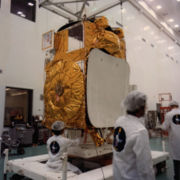
Extraterrestrial exploration
India's first mission beyond Earth's orbit was Chandrayaan-1, a lunar spacecraft which successfully entered the lunar orbit on 8 November 2008. ISRO plans to follow up Chandrayaan-1 with Chandrayaan-2Chandrayaan-2
Chandrayaan-2 , is a joint lunar exploration mission proposed by the Indian Space Research Organisation and the Russian Federal Space Agency and has a projected cost of...
and unmanned missions to Mars
Mars
Mars is the fourth planet from the Sun in the Solar System. The planet is named after the Roman god of war, Mars. It is often described as the "Red Planet", as the iron oxide prevalent on its surface gives it a reddish appearance...
and Near-Earth object
Near-Earth object
A near-Earth object is a Solar System object whose orbit brings it into close proximity with the Earth. All NEOs have a perihelion distance less than 1.3 AU. They include a few thousand near-Earth asteroids , near-Earth comets, a number of solar-orbiting spacecraft, and meteoroids large enough to...
s such as asteroids and comets.
Lunar exploration
Chandrayaan-1 (Sanskrit: चंद्रयान-१) is India's first mission to the moon. The unmanned lunar exploration mission includes a lunar orbiter and an impactor called the Moon Impact ProbeMoon Impact Probe
The Moon Impact Probe developed by the Indian Space Research Organisation , India's national space agency, was a lunar probe that was released by ISRO's Chandrayaan-1 lunar remote sensing orbiter which in turn was launched, on 22 October 2008, aboard a modified version of ISRO's Polar Satellite...
. India launched the spacecraft using a modified version of the PSLV is C11 on 22 October 2008 from Satish Dhawan Space Centre
Satish Dhawan Space Centre
The Satish Dhawan Space Centre is the launch centre for the Indian Space Research Organisation . It is located in Sriharikota, Andhra Pradesh, India, north of Chennai in South India. It was originally called Sriharikota High Altitude Range , and was sometime known as Sriharikota Launching Range...
, Sriharikota. The vehicle was successfully inserted into lunar orbit on 8 November 2008. It carries high-resolution remote sensing equipment for visible, near infrared, and soft and hard X-ray frequencies. Over its two-year operational period, it is intended to survey the lunar surface to produce a complete map of its chemical characteristics and 3-dimensional topography. The polar regions are of special interest, as they might contain ice
Lunar ice
Lunar water is water that is present on the Moon. Liquid water cannot persist at the Moon's surface, and water vapour is quickly decomposed by sunlight and lost to outer space...
. The lunar mission carries five ISRO payloads and six payloads from other international space agencies including NASA
NASA
The National Aeronautics and Space Administration is the agency of the United States government that is responsible for the nation's civilian space program and for aeronautics and aerospace research...
, ESA, and the Bulgarian Aerospace Agency
Bulgarian Aerospace Agency
Space research in Bulgaria is coordinated by the Inter-Department Commission for Space Research which is constituted from the deputy ministers of several ministries and representatives of the Bulgarian Academy of Sciences . Co-chairman is the President of BAS...
, which were carried free of cost. The Chandrayaan-1 became the first lunar mission to discover existence of water on the moon.
Planetary exploration
The Indian Space Research Organisation had begun preparations for a mission to Mars and had received seed money of 10 crore from the government.The space agency was looking at launch opportunities between 2013 and 2015. The space agency would use its Geosynchronous Satellite Launch VehicleGeosynchronous Satellite Launch Vehicle
The Geosynchronous Satellite Launch Vehicle is an expendable launch system operated by the Indian Space Research Organisation...
(GSLV) to put the satellite in orbit and was considering using ion-thrusters, liquid engines or nuclear power
Nuclear power
Nuclear power is the use of sustained nuclear fission to generate heat and electricity. Nuclear power plants provide about 6% of the world's energy and 13–14% of the world's electricity, with the U.S., France, and Japan together accounting for about 50% of nuclear generated electricity...
to propel it further towards Mars. The Mars mission studies had already been completed and that space scientists were trying to collect scientific proposals and scientific objectives.
Human spaceflight program
The Indian Space Research Organization has been sanctioned a budget of for its human spaceflight program. According to the Space Commission which passed the budget, an unmanned flight will be launched in 2013 and manned mission will launch in 2016. If realized in the stated time-frame, India will become the fourth nation, after the USSR
Soviet Union
The Soviet Union , officially the Union of Soviet Socialist Republics , was a constitutionally socialist state that existed in Eurasia between 1922 and 1991....
, USA
United States
The United States of America is a federal constitutional republic comprising fifty states and a federal district...
and China
People's Republic of China
China , officially the People's Republic of China , is the most populous country in the world, with over 1.3 billion citizens. Located in East Asia, the country covers approximately 9.6 million square kilometres...
, to successfully carry out manned missions indigenously.
Technology demonstration
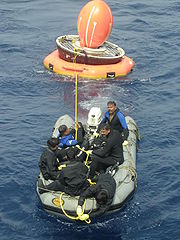
The Space Capsule Recovery ExperimentSpace Capsule Recovery Experiment
The Space Capsule Recovery Experiment is an Indian experimental spacecraft which was launched at 03:53 GMT on January 10, 2007 from Sriharikota by the Indian Space Research Organization . The launch was conducted using the PSLV C7 rocket, along with three other satellites...
(SCRE or more commonly SRE or SRE-1) is an experimental Indian spacecraft which was launched using the PSLV C7 rocket, along with three other satellites. It remained in orbit for 12 days before re-entering the Earth's atmosphere and splashing down into the Bay of Bengal.
The SRE-1 was designed to demonstrate the capability to recover an orbiting space capsule, and the technology for performing experiments in the microgravity conditions of an orbiting platform. It was also intended to test thermal protection, navigation, guidance, control, deceleration and flotation systems, as well as study hypersonic aero-thermodynamics, management of communication blackouts, and recovery operations.
ISRO also plans to launch SRE-2 and SRE-3 in the near future to test advanced re-entry technology for future manned missions.
Astronaut training and other facilities
ISRO will set up an astronaut training centre in BangaloreBangalore
Bengaluru , formerly called Bengaluru is the capital of the Indian state of Karnataka. Bangalore is nicknamed the Garden City and was once called a pensioner's paradise. Located on the Deccan Plateau in the south-eastern part of Karnataka, Bangalore is India's third most populous city and...
by 2012 to prepare personnel for flights on board the crewed vehicle. The centre will use water simulation to train the selected astronauts in rescue and recovery operations and survival in zero gravity, and will undertake studies of the radiation environment of space.
ISRO will build centrifuges
High-G training
High-G training is done by aviators and astronauts who are subject to high levels of acceleration . It is designed to prevent a g-induced Loss Of Consciousness , a situation when g-forces move the blood away from the brain to the extent that consciousness is lost.Incidents of acceleration-induced...
to prepare astronauts for the acceleration phase of the mission. It also plans to build a new Launch pad to meet the target of launching a manned space mission by 2015. This would be the third launchpad at the Satish Dhawan Space Centre
Satish Dhawan Space Centre
The Satish Dhawan Space Centre is the launch centre for the Indian Space Research Organisation . It is located in Sriharikota, Andhra Pradesh, India, north of Chennai in South India. It was originally called Sriharikota High Altitude Range , and was sometime known as Sriharikota Launching Range...
, Sriharikota.
Development of crew vehicle
The Indian Space Research Organisation (ISRO) is working towards a maiden manned Indian space mission vehicle that can carry three astronauts for seven days in a near earth orbit. The Indian manned spacecraft temporarily named as Orbital VehicleISRO Orbital Vehicle
The Indian manned spacecraft temporarily named Orbital Vehicle is intended to be the basis of the indigenous Indian human spaceflight program. The capsule will be designed to carry three people, and a planned upgraded version will be equipped with rendezvous and docking capability.In its maiden...
intend to be the basis of indigenous Indian human spaceflight program.
The capsule will be designed to carry three people, and a planned upgraded version will be equipped with a rendezvous and docking capability. In its maiden manned mission, ISRO's largely autonomous 3-ton capsule will orbit the Earth at 248 miles (400 km) in altitude for up to seven days with a two-person crew on board. The crew vehicle would launch atop of ISRO's GSLV Mk II, currently under development. The GSLV Mk II features an indigenously developed cryogenic upper-stage engine. The first test of the cryogenic engine, held on 15 April 2010, failed as the cryogenic phase did not perform as expected and rocket deviated from the planned trajectory. A future launch has been scheduled for 2011. If successful then ISRO will become the sixth entity, after United States
NASA
The National Aeronautics and Space Administration is the agency of the United States government that is responsible for the nation's civilian space program and for aeronautics and aerospace research...
, Russia
Russian Federal Space Agency
The Russian Federal Space Agency , commonly called Roscosmos and abbreviated as FKA and RKA , is the government agency responsible for the Russian space science program and general aerospace research. It was previously the Russian Aviation and Space Agency .Headquarters of Roscosmos are located...
, China
China National Space Administration
The China National Space Administration is the national space agency of the People's Republic of China responsible for the national space program. It is responsible for planning and development of space activities...
, Japan
Japan Aerospace Exploration Agency
The , or JAXA, is Japan's national aerospace agency. Through the merger of three previously independent organizations, JAXA was formed on October 1, 2003, as an Independent Administrative Institution administered by the Ministry of Education, Culture, Sports, Science and Technology and the...
and Europe
European Space Agency
The European Space Agency , established in 1975, is an intergovernmental organisation dedicated to the exploration of space, currently with 18 member states...
, to develop this technology.
Planetary sciences and astronomy
India's space era dawned when the first two-stage sounding rocket was launched from ThumbaThumba
Thumba is a suburb of Thiruvananthapuram city, capital of Kerala, India.Thumba became well-known to the out-siders after the establishment of Thumba Equatorial Rocket Launching Station , which was the first of that kind in India...
in 1963. Even before this, noteworthy contributions were made by the Indian scientists in the following areas of space science research:
- Cosmic rays and high energy astronomy using both ground based as well as balloon borne experiments/studies such as neutron/meson monitors, Geiger Muller particle detectorGeiger–Müller tubeA Geiger–Müller tube is the sensing element of a Geiger counter instrument that can detect a single particle of ionizing radiation, and typically produce an audible click for each. It was named for Hans Geiger who invented the device in 1908, and Walther Müller who collaborated with Geiger in...
s/counters etc. - Ionospheric research using ground based radio propagation techniques such as ionosondeIonosondeAn ionosonde, or chirpsounder, is a special radar for the examination of the ionosphere. An ionosonde consists of:* A high frequency transmitter, automatically tunable over a wide range...
, VLF/HF/VHF radio probing, a chain of magnetometer stations etc. - Upper atmospheric research using ground based optical techniques such as Dobson spectrometers for measurement of total ozone content, air glow photometers etc.
- Indian astronomers have been carrying out major investigations using a number of ground based optical and radio telescopes with varying sophistication.
With the advent of the Indian space program, emphasis was laid on indigenous, self-reliant and state-of-the-art development of technology for immediate practical applications in the fields of space science research activities in the country.
There is a national balloon launching facility at Hyderabad jointly supported by TIFR and ISRO. This facility has been extensively used for carrying out research in high energy (i.e., X- and gamma ray) astronomy, IR astronomy, middle atmospheric trace constituents including CFCs & aerosols, ionisation, electric conductivity and electric fields.
The flux of secondary particles and X-ray
X-ray
X-radiation is a form of electromagnetic radiation. X-rays have a wavelength in the range of 0.01 to 10 nanometers, corresponding to frequencies in the range 30 petahertz to 30 exahertz and energies in the range 120 eV to 120 keV. They are shorter in wavelength than UV rays and longer than gamma...
and gamma-rays of atmospheric origin produced by the interaction of the cosmic rays is very low. This low background, in the presence of which one has to detect the feeble signal from cosmic sources is a major advantage in conducting hard X-ray observations from India. The second advantage is that many bright sources like Cyg X-1, Crab Nebula
Crab Nebula
The Crab Nebula is a supernova remnant and pulsar wind nebula in the constellation of Taurus...
, Scorpius X-1
Scorpius X-1
Scorpius X-1 is an X-ray source located roughly 9000 light years away in the constellation Scorpius. Scorpius X-1 was the first extrasolar X-ray source discovered, and, aside from the Sun, it is the strongest source of X-rays in the sky...
and Galactic Centre sources are observable from Hyderabad due to their favourable declination. With these considerations, an X-ray astronomy
X-ray astronomy
X-ray astronomy is an observational branch of astronomy which deals with the study of X-ray observation and detection from astronomical objects. X-radiation is absorbed by the Earth's atmosphere, so instruments to detect X-rays must be taken to high altitude by balloons, sounding rockets, and...
group was formed at TIFR in 1967 and development of an instrument with an orientable X-ray telescope
X-ray telescope
An X-ray telescope is a telescope that is designed to observe remote objects in the X-ray spectrum. In order to get above the Earth's atmosphere, which is opaque to X-rays, X-ray telescopes must be mounted on high altitude rockets or artificial satellites.-Optical design:X-ray telescopes can use...
for hard X-ray observations was undertaken. The first balloon flight with the new instrument was made on 28 April 1968 in which observations of Scorpius X-1 were successfully carried out. In a succession of balloon flights made with this instrument between 1968 and 1974 a number of binary X-ray sources including Scorpius X-1, Cyg X-1
Cygnus X-1
Cygnus X-1 is a well-known galactic X-ray source in the constellation Cygnus. It was discovered in 1964 during a rocket flight and is one of the strongest X-ray sources seen from Earth, producing a peak X-ray flux density of 2.3 Wm−2Hz−1...
, Her X-1 etc. and the diffuse cosmic X-ray background were studied. Many new and astrophysically important results were obtained from these observations.
One of most important achievements of ISRO in this field was the discovery of three species of bacteria in the upper stratosphere at an altitude of between 20–40 km. The bacteria, highly resistant to ultra-violet radiation, are not found elsewhere on Earth, leading to speculation on whether they are extraterrestrial in origin. These three bacteria can be considered to be extremophile
Extremophile
An extremophile is an organism that thrives in physically or geochemically extreme conditions that are detrimental to most life on Earth. In contrast, organisms that live in more moderate environments may be termed mesophiles or neutrophiles...
s. Until then, the upper stratosphere was believed to be inhospitable because of the high doses of ultra-violet radiation. The bacteria were named as Bacillus isronensis in recognition of ISRO's contribution in the balloon experiments, which led to its discovery, Bacillus aryabhata after India's celebrated ancient astronomer Aryabhata
Aryabhata
Aryabhata was the first in the line of great mathematician-astronomers from the classical age of Indian mathematics and Indian astronomy...
and Janibacter Hoylei after the distinguished astrophysicist Fred Hoyle
Fred Hoyle
Sir Fred Hoyle FRS was an English astronomer and mathematician noted primarily for his contribution to the theory of stellar nucleosynthesis and his often controversial stance on other cosmological and scientific matters—in particular his rejection of the "Big Bang" theory, a term originally...
.
Research facilities
| Facility | Location | Description |
|---|---|---|
| Physical Research Laboratory Physical Research Laboratory The Physical Research Laboratory is a national Research Institute for space and allied sciences, supported mainly by Department of Space, Government of India. This research laboratory has ongoing research programmes in Astronomy and Astrophysics, Atmospheric Sciences and Aeronomy, Earth Sciences,... |
Ahmedabad Ahmedabad Ahmedabad also known as Karnavati is the largest city in Gujarat, India. It is the former capital of Gujarat and is also the judicial capital of Gujarat as the Gujarat High Court has its seat in Ahmedabad... |
Solar planetary physics, infrared astronomy, geo-cosmo physics, plasma physics, astrophysics Astrophysics Astrophysics is the branch of astronomy that deals with the physics of the universe, including the physical properties of celestial objects, as well as their interactions and behavior... , archaeology Archaeology Archaeology, or archeology , is the study of human society, primarily through the recovery and analysis of the material culture and environmental data that they have left behind, which includes artifacts, architecture, biofacts and cultural landscapes... , and hydrology Hydrology Hydrology is the study of the movement, distribution, and quality of water on Earth and other planets, including the hydrologic cycle, water resources and environmental watershed sustainability... are some of the branches of study at this institute. An observatory at Udaipur Udaipur Udaipur , also known as the City of Lakes, is a city, a Municipal Council and the administrative headquarters of the Udaipur district in the state of Rajasthan in western India. It is located southwest of the state capital, Jaipur, west of Kota, and northeast from Ahmedabad... also falls under the control of this institution. |
| Semi-Conductor Laboratory Semi-Conductor Laboratory The Semi-Conductor Laboratory, Chandigarh, is a research institute of the Department of Space, Government of India. Its aims include research and development in the field of Semiconductor technology.... |
Chandigarh Chandigarh Chandigarh is a union territory of India that serves as the capital of two states, Haryana and Punjab. The name Chandigarh translates as "The Fort of Chandi". The name is from an ancient temple called Chandi Mandir, devoted to the Hindu goddess Chandi, in the city... |
Research & Development in the field of semiconductor technology, micro-electromechanical systems and process technologies relating to semiconductor processing. |
| National Atmospheric Research Laboratory National Atmospheric Radar Laboratory The National Atmospheric Research Laboratory [or राष्ट्रीय वायुमण्डलीय अनुसंधान प्रयोगशाला] is an autonomous Research Institute funded by the Department of Space of the Government of India. NARL is engaged in fundamental and applied research in the field of Atmospheric Sciences... |
Chittoor Chittoor Chittoor also known as Chittur, is a City and municipal corporation located in the Chittoor District of Andhra Pradesh, India. It is conveniently located on major highways linking the cities of Bangalore and Chennai.... |
The NARL carries out fundamental and applied research in Atmospheric and Space Sciences. |
| Raman Research Institute (RRI) Raman Research Institute Raman Research Institute is a research institute in Bangalore, India. It was started by Nobel laureate Sir C. V. Raman.The main areas of research are:*Astronomy and Astrophysics*Liquid Crystals*Theoretical Physics*Optics... |
Bangalore Bangalore Bengaluru , formerly called Bengaluru is the capital of the Indian state of Karnataka. Bangalore is nicknamed the Garden City and was once called a pensioner's paradise. Located on the Deccan Plateau in the south-eastern part of Karnataka, Bangalore is India's third most populous city and... |
RRI carries out research in selected areas of physics, such as astrophysics and astronomy. |
| Space Applications Centre Space Applications Centre The Space Applications Centre is an institution of research in Ahmedabad, India under the aegis of the Indian Space Research Organization... |
Ahmedabad Ahmedabad Ahmedabad also known as Karnavati is the largest city in Gujarat, India. It is the former capital of Gujarat and is also the judicial capital of Gujarat as the Gujarat High Court has its seat in Ahmedabad... |
The SAC deals with the various aspects of practical use of space technology. Among the fields of research at the SAC are geodesy Geodesy Geodesy , also named geodetics, a branch of earth sciences, is the scientific discipline that deals with the measurement and representation of the Earth, including its gravitational field, in a three-dimensional time-varying space. Geodesists also study geodynamical phenomena such as crustal... , satellite based telecommunications Telecommunication Telecommunication is the transmission of information over significant distances to communicate. In earlier times, telecommunications involved the use of visual signals, such as beacons, smoke signals, semaphore telegraphs, signal flags, and optical heliographs, or audio messages via coded... , surveying Surveying See Also: Public Land Survey SystemSurveying or land surveying is the technique, profession, and science of accurately determining the terrestrial or three-dimensional position of points and the distances and angles between them... , remote sensing Remote sensing Remote sensing is the acquisition of information about an object or phenomenon, without making physical contact with the object. In modern usage, the term generally refers to the use of aerial sensor technologies to detect and classify objects on Earth by means of propagated signals Remote sensing... , meteorology Meteorology Meteorology is the interdisciplinary scientific study of the atmosphere. Studies in the field stretch back millennia, though significant progress in meteorology did not occur until the 18th century. The 19th century saw breakthroughs occur after observing networks developed across several countries... , environment monitoring etc. The SEC additionally operates the Delhi Earth Station. |
| North Eastern-Space Applications Center | Shillong Shillong -Connectivity:Although well connected by road, Shillong has no rail connection and a proper air connection. Umroi Airport exists but has only limited flights.-Roadways:Shillong is well connected by roads with all major north eastern states... |
Providing developmental support to North East by undertaking specific application projects using remote sensing, GIS, satellite communication and conducting space science research. |
Test facilities
| Facility | Location | Description |
|---|---|---|
| Liquid Propulsion Systems Centre Liquid Propulsion Systems Centre The Liquid Propulsion Systems Centre , located at three places, Valiyamala, near Nedumangad in Thiruvananthapuram District, Kerala, Mahendragiri in Thirunelveli District of Tamil Nadu and Bangaluru, Karnataka... |
Bangalore, Thiruvananthapuram, and Nagercoil Nagercoil Nagercoil is the 12th largest city in the southernmost Indian state of Tamil Nadu and a municipality and administrative headquarters of Kanyakumari District... |
The LPSC handles testing and implementation of liquid propulsion control packages and helps develop engines for launch vehicles and satellites. The testing is largely conducted at Mahendragiri. The LPSC also constructs precision transducers. |
Construction and launch facilities
| Facility | Location | Description |
|---|---|---|
| ISRO Satellite Centre | Bangalore Bangalore Bengaluru , formerly called Bengaluru is the capital of the Indian state of Karnataka. Bangalore is nicknamed the Garden City and was once called a pensioner's paradise. Located on the Deccan Plateau in the south-eastern part of Karnataka, Bangalore is India's third most populous city and... |
The venue of eight successful spacecraft projects is also one of the main satellite technology bases of ISRO. The facility serves as a venue for implementing indigenous spacecraft in India. The satellites Ayrabhata, Bhaskara, APPLE, and IRS-1A were constructed at this site, and the IRS and INSAT satellite series are presently under development here. |
| Laboratory for Electro-Optics Systms-LEOS | Bangalore Bangalore Bengaluru , formerly called Bengaluru is the capital of the Indian state of Karnataka. Bangalore is nicknamed the Garden City and was once called a pensioner's paradise. Located on the Deccan Plateau in the south-eastern part of Karnataka, Bangalore is India's third most populous city and... |
The Unit of ISRO responsible for the development of attitude sensors for all satellites. The high precision optics for all cameras and payloads in all ISRO satellites including Chandrayaan-1 are developed at this laboratory. Located at Peenya Industrial Estate, Bangalore. |
| Satish Dhawan Space Centre Satish Dhawan Space Centre The Satish Dhawan Space Centre is the launch centre for the Indian Space Research Organisation . It is located in Sriharikota, Andhra Pradesh, India, north of Chennai in South India. It was originally called Sriharikota High Altitude Range , and was sometime known as Sriharikota Launching Range... |
Sriharikota Sriharikota Sriharikota is a barrier island off the coast of the southern state of Andhra Pradesh in India. It houses India's only satellite launch centre in the Satish Dhawan Space Centre and is used by the Indian Space Research Organisation to launch satellites using multi-stage rockets such as the Polar... |
With multiple sub-sites the Sriharikota island facility acts as a launching site for India's satellites. The Sriharikota facility is also the main launch base for India's sounding rockets. The centre is also home to India's largest Solid Propellant Space Booster Plant (SPROB) and houses the Static Test and Evaluation Complex (STEX). |
| Vikram Sarabhai Space Centre Vikram Sarabhai Space Centre The Vikram Sarabhai Space Centre is a major space research centre of the Indian Space Research Organisation , focusing on rocket and space vehicles for India's satellite programme... |
Thiruvananthapuram Thiruvananthapuram Thiruvananthapuram , formerly known as Trivandrum, is the capital of the Indian state of Kerala and the headquarters of the Thiruvananthapuram District. It is located on the west coast of India near the extreme south of the mainland... |
The largest ISRO base is also the main technical centre and the venue of development of the SLV-3 Satellite Launch Vehicle The Indian Satellite Launch Vehicle or SLV was a project started in the early 1970s by Indian Space Research Organisation to develop the technology needed to launch satellites. The project was headed by Dr. APJ Abdul Kalam. SLV was intended to reach a height of 400 km and carry a payload of... , ASLV ASLV Augmented Satellite Launch Vehicle , was a 5-stage solid propellant rocket developed by the Indian Space Research Organisation to place 150 kg satellites into LEO. This project was started by India during the early 1980s to develop technologies needed for a payload to be placed into a... , and PSLV series. The base supports India's Thumba Equatorial Rocket Launching Station Thumba Equatorial Rocket Launching Station The Thumba Equatorial Rocket Launching Station is an Indian spaceport, operated by the Indian Space Research Organization. It is located in Thumba, Thiruvananthapuram which is near the southern tip of India, very close to earth's magnetic equator... and the Rohini Sounding Rocket program. This facility is also developing the GSLV series. |
| Thumba Equatorial Rocket Launching Station Thumba Equatorial Rocket Launching Station The Thumba Equatorial Rocket Launching Station is an Indian spaceport, operated by the Indian Space Research Organization. It is located in Thumba, Thiruvananthapuram which is near the southern tip of India, very close to earth's magnetic equator... |
Thiruvananthapuram Thiruvananthapuram Thiruvananthapuram , formerly known as Trivandrum, is the capital of the Indian state of Kerala and the headquarters of the Thiruvananthapuram District. It is located on the west coast of India near the extreme south of the mainland... |
TERLS is used to launch sounding rockets. |
Tracking and control facilities
| Facility | Location | Description |
|---|---|---|
| Indian Deep Space Network (IDSN) Indian Deep Space Network The Indian Deep Space Network is a network of large antennas and communication facilities that supports the interplanetary spacecraft missions of India. It is located at Byalalu, a village about 100 km from Bangalore, India. It was officially inaugurated on 17 October 2008 by ISRO chairman... |
Bangalore Bangalore Bengaluru , formerly called Bengaluru is the capital of the Indian state of Karnataka. Bangalore is nicknamed the Garden City and was once called a pensioner's paradise. Located on the Deccan Plateau in the south-eastern part of Karnataka, Bangalore is India's third most populous city and... |
This network receives, processes, archives and distributes the spacecraft health data and payload data in real time. It can track and monitor satellites up to very large distances, even beyond the Moon Moon The Moon is Earth's only known natural satellite,There are a number of near-Earth asteroids including 3753 Cruithne that are co-orbital with Earth: their orbits bring them close to Earth for periods of time but then alter in the long term . These are quasi-satellites and not true moons. For more... . |
| National Remote Sensing Centre | Hyderabad | The NRSC applies remote sensing to manage natural resources and study aerial surveying. With centres at Balanagar Balanagar Balanagar is a mandal in Ranga Reddy district of Andhra Pradesh, India. Balanagar is one of the major Industrial estates in India located in north west side of Hyderabad. Several Government owned industries are established in this location. IDPL, IDL, NRSA , HAL , BHEL R&D Are few amongst them... and Shadnagar Mahbubnagar district Mahabubnagar or Mahboobnagar , also known as Palamooru is a district in the Andhra Pradesh state of India, in the Telangana region. It is named after its largest city and district headquarters, Mahabubnagar.It is the second largest district in the state in terms of area... it also has training facilities at Dehradun Dehradun - Geography :The Dehradun district has various types of physical geography from Himalayan mountains to Plains. Raiwala is the lowest point at 315 meters above sea level, and the highest points are within the Tiuni hills, rising to 3700 m above sea level... in form of the Indian Institute of Remote Sensing Indian Institute of Remote Sensing The Indian Institute of Remote Sensing is the training and education arm of the Indian Department of Space. Located in Dehradun, the institute offers courses in Remote sensing and Geographic Information Systems , ranging in length from one week to two years.-History:Formerly known as the Indian... . |
| Indian Space Research Organisation Telemetry, Tracking and Command Network Indian Space Research Organisation Telemetry, Tracking and Command Network The Indian Space Research Organization , over the years, established a comprehensive network of ground stations to provide Telemetry, Tracking and Command support to satellite and launch vehicle missions... |
Bangalore (headquarters) and a number of ground stations throughout India and World. | Software development Software development Software development is the development of a software product... , ground operations, Tracking Telemetry and Command (TTC), and support is provided by this institution. ISTRAC has Tracking stations throughout the country and all over the world in Port Louis Port Louis -Economy:The economy is dominated by its port, which handles Mauritius' international trade. The port was founded by the French who preferred Port Louis as the City is shielded by the Port Louis/Moka mountain range. It is the largest container handling facility in the Indian Ocean and can... (Mauritius Mauritius Mauritius , officially the Republic of Mauritius is an island nation off the southeast coast of the African continent in the southwest Indian Ocean, about east of Madagascar... ), Bearslake (Russia Russia Russia or , officially known as both Russia and the Russian Federation , is a country in northern Eurasia. It is a federal semi-presidential republic, comprising 83 federal subjects... ), Biak Biak Biak features a tropical rainforest climate with nearly identical temperatures throughout the course of the year. The average annual temperature in the city is 27 degrees celsius, which is also generally the average temperature of each day in Biak... (Indonesia Indonesia Indonesia , officially the Republic of Indonesia , is a country in Southeast Asia and Oceania. Indonesia is an archipelago comprising approximately 13,000 islands. It has 33 provinces with over 238 million people, and is the world's fourth most populous country. Indonesia is a republic, with an... ) and Brunei Brunei Brunei , officially the State of Brunei Darussalam or the Nation of Brunei, the Abode of Peace , is a sovereign state located on the north coast of the island of Borneo, in Southeast Asia... . |
| Master Control Facility | Hassan; Karnataka Karnataka Karnataka , the land of the Kannadigas, is a state in South West India. It was created on 1 November 1956, with the passing of the States Reorganisation Act and this day is annually celebrated as Karnataka Rajyotsava... |
Geostationary satellite orbit raising, payload testing, and in-orbit operations are performed at this facility. The MCF has earth stations and Satellite Control Centre (SCC) for controlling satellites. A second MCF-like facility named 'MCF-B' is being constructed at Bhopal. |
Human resource development
| Facility | Location | Description |
|---|---|---|
| Indian Institute of Remote Sensing Indian Institute of Remote Sensing The Indian Institute of Remote Sensing is the training and education arm of the Indian Department of Space. Located in Dehradun, the institute offers courses in Remote sensing and Geographic Information Systems , ranging in length from one week to two years.-History:Formerly known as the Indian... (IIRS) |
Dehradun Dehradun - Geography :The Dehradun district has various types of physical geography from Himalayan mountains to Plains. Raiwala is the lowest point at 315 meters above sea level, and the highest points are within the Tiuni hills, rising to 3700 m above sea level... |
Indian Institute of Remote Sensing (IIRS) under National Remote Sensing Centre, Department of Space, Govt. of India is a premier training and educational institute set up for developing trained professional in the field of Remote Sensing, Geoinformatics and GPS Technology for Natural Resources, Environmental and Disaster Management. |
| Indian Institute of Space Science and Technology (IIST) | Thiruvananthapuram Thiruvananthapuram Thiruvananthapuram , formerly known as Trivandrum, is the capital of the Indian state of Kerala and the headquarters of the Thiruvananthapuram District. It is located on the west coast of India near the extreme south of the mainland... |
The institute offers undergraduate and graduate courses in Aerospace engineering, Avionics and Physical Sciences. The students of first batch of IIST were inducted into different ISRO centres by end of July 2011. |
| Development and Educational Communication Unit | Ahmedabad Ahmedabad Ahmedabad also known as Karnavati is the largest city in Gujarat, India. It is the former capital of Gujarat and is also the judicial capital of Gujarat as the Gujarat High Court has its seat in Ahmedabad... |
The centre works for education, research, and training, mainly in conjunction with the INSAT program. The main activities carried out at DECU include GRAMSAT and EDUSAT projects. The Training and Development Communication Channel (TDCC) also falls under the operational control of the DECU. |
Commercial wing
| Facility | Location | Description |
|---|---|---|
| Antrix Corporation Antrix Corporation Antrix Corporation Limited is commercial wing of Indian Space Research Organization . The name "Antrix" is an anglicized version of Antariksh, from the Sanskrit word for "space" or "sky".-Products and services:... |
Bangalore | The marketing agency under government control markets ISRO's hardware, manpower, and software. |
Other facilities include:
- Balasore Rocket Launching Station (BRLS)BalasoreBalasore is a strategically located city in the state of Orissa, about north of the state capital Bhubaneswar, in eastern India. It is the administrative headquarters of Balasore district. It is best known for Chandipur beach. It is also the site of the Indian Ballistic Missile Defense...
– OrissaOrissaOrissa , officially Odisha since Nov 2011, is a state of India, located on the east coast of India, by the Bay of Bengal. It is the modern name of the ancient nation of Kalinga, which was invaded by the Maurya Emperor Ashoka in 261 BC. The modern state of Orissa was established on 1 April... - INSAT Master Control Facility (IMCF) – Bhopal
- ISRO Inertial Systems Unit (IISU)ISRO Inertial Systems UnitThe ISRO Inertial Systems Unit is a research and development unit of the Indian Space Research Organisation located in Thiruvananthapuram that specialises in inertial sensors and systems in satellite technology...
– ThiruvananthapuramThiruvananthapuramThiruvananthapuram , formerly known as Trivandrum, is the capital of the Indian state of Kerala and the headquarters of the Thiruvananthapuram District. It is located on the west coast of India near the extreme south of the mainland... - Indian Regional Navigational Satellite System (IRNSS)Indian Regional Navigational Satellite SystemThe Indian Regional Navigational Satellite System is an autonomous regional satellite navigation system being developed by the Indian Space Research Organisation which would be under total control of Indian government...
- Aerospace Command of India (ACI)
- Indian National Committee for Space Research (INCOSPAR)Indian National Committee for Space ResearchThe Indian National Committee for Space Research was set up in 1962 by the Indian Government under Dr. Vikram Sarabhai to formulate the Indian Space Program. At the time, the committee was part of the Tata Institute of Fundamental Research, led by M. G. K. Menon. The committee took over the...
- Inter University Centre for Astronomy and Astrophysics (IUCAA)Inter-University Centre for Astronomy and AstrophysicsThe Inter-University Centre for Astronomy and Astrophysics is an autonomous institution set up by the University Grants Commission to promote nucleation and growth of active groups in astronomy and astrophysics in Indian universities...
- Indian Department of Space (IDS)Department of SpaceThe Department of Space is an Indian government department responsible for administration of the Indian space program.The Indian Space Research Organization is the primary research and development arm of the DoS...
- Indian Space Science Data Centre (ISSDC)
- Spacecraft Control Centre (SCC)
- Regional Remote Sensing Service Centres (RRSSC)
- Development and Educational Communication Unit (DECU)
Vision for the future
Forthcoming Satellites
| Satellite Name | Details |
|---|---|
| RISAT - 1 | Radar Imaging Satellite (RISAT) is a microwave remote sensing satellite carrying a Synthetic Aperture Radar (SAR) The satellite weighing around 1850 kg is in the final stages of development for a launch in 2011 into a 536 km orbit with 25 days repetitivity with an added advantage of 12 days inner cycle for Coarse Resolution ScanSAR mode. |
| INSAT - 3D | INSAT-3D is a meteorological satellite, planned to be launched on-board GSLV in 2011. The satellite has many new technology elements like star sensor, micro stepping Solar Array Drive Assembly (SADA) to reduce the spacecraft disturbances and Bus Management Unit (BMU) for control and telecomm and/telemetry function. It also incorporates new features of bi-annual rotation and Image and Mirror motion compensations for improved performance of the meteorological payloads. |
| SARAL | The Satellite for ARGOS and ALTIKA (SARAL) is a joint ISRO-CNES mission and planned to be launched during 2011. The Ka band altimeter, ALTIKA, provided by CNES payload consists of a Ka-band radar altimeter, operating at 35.75 GHz. A dual frequency total power type microwave radiometer (23.8 and 37 GHz) is embedded in the altimeter to correct tropospheric effects on the altimeter measurement. Doppler Orbitography and Radio-positioning Integrated by Satellite (DORIS) on board enables precise determination of the orbit. A Laser Retroreflector Array (LRA) helps to calibrate the precise orbit determination system and the altimeter system several times throughout the mission. |
| ASTROSAT | ASTROSAT is a first dedicated Indian Astronomy satellite mission, which will enable multi-wavelength observations of the celestial bodies and cosmic sources in X-ray and UV spectral bands simultaneously. The scientific payloads cover the Visible (3500-6000 Å ), UV (1300-3000 Å ), soft and hard X-ray regimes (0.5-8 keV; 3-80 keV). The uniqueness of ASTROSAT lies in its wide spectral coverage extending over visible, UV, soft and hard X-ray regions. |
| GSAT-6 / INSAT-4E | The primary goal of GSAT-6/INSAT-4E, which is a Multimedia broadcast satellite, is to cater to the consumer requirements of providing entertainment and information services to vehicles through Digital Multimedia consoles and to the Multimedia mobile Phones. The satellite carries a 5 spot beam BSS and 5 spot beam MSS. It will be positioned at 83º East longitude with a mission life of 12 years. |
| GSAT-7 / INSAT-4F | GSAT-7/INSAT-4F is a multi-band satellite carrying payloads in UHF, S-band, C-band and . The satellite weighs 2330 kg with a payload power of 2000W and mission life of 9 years. |
| GSAT-9 | GSAT-9 will carry 6 C band and 24 transponders with India coverage beam. The satellite is planned to be launched during 2011-12 with a mission life of 12 years and positioned at 48º East longitude. This I-2K satellite has a liftoff mass of 2330 kg and payload power of 2300 W. |
| GSAT-10 | GSAT-I0 will carry 12 Normal C-band, 12 Extended C-band and 12 transponders. It will also carry GPS Aided Geo Augmented Navigation (GAGAN) payload. The satellite is planned to be launched during 2011 with a mission life of 15 years and positioned at 83º East longitude. This I-3K satellite with liftoff mass of 3435 kg and payload power of 4500 W will be launched on board ARIANE-5. |
| GSAT-11 | GSAT-11 is based on I-4K bus which is under advanced stage of development. The spacecraft can generate 10-12 KW of power and can support payload power of 8KW. The payload configuration is on-going. It consists of 16 spot beams covering entire country including Andaman & Nicobar islands. The communication link to the user-end terminals operate in Ku-band while the communication link to the hubs operate in Ka-band. The payload is configured to be operated as a high data throughput satellite, to be realised in orbit in 2013 time frame. |
| GSAT-14 | GSAT-14 is intended to serve as a replacement for EDUSAT as the spacecraft is configured with 6 Ku and 6 Ext C band transponders providing India coverage beams. In addition, the spacecraft also carries Ka band beacons, which are planned to be used to carry out studies related to rain and atmospheric effects on Ka band satellite communication links in Indian region. The spacecraft weighs around 2050 kg and is planned to be launched by GSLV with indigenous cryogenic upper stage. |
| IRNSS-1 | Indian Regional Navigational Satellite System (IRNSS)-1, the first of the seven satellites of the IRNSS constellation, carries a Navigation payload and a C-band ranging transponder. The spacecraft employs an optimised I-1K structure with a power handling capability of around 1600W and a lift off mass of 1380 kg, and is designed for a nominal mission life of 7 years. The first satellite of IRNSS constellation is planned to be launched onboard PSLV during 2012-13 while the full constellation is planned to be realised during 2014 time frame. |
Future launch vehicles
GSLV-Mk IIIGSLV-Mk III is envisaged to launch four tonne satellite into geosynchronous transfer orbit. GSLV-Mk III is a three-stage vehicle with a 110 tonne core liquid propellant stage (L-110) and a strap-on stage with two solid propellant motors, each with 200 tonne propellant (S-200). The upper stage will be cryogenic with a propellant loading of 25 tonne (C-25). GSLV Mk-III will have a lift-off weight of about 626 tonne and will be 43.43 m tall. The payload fairing will have a diameter of 5 metre and a payload volume of 100 cubic metre. GSLV Mk III is planned to be launched during 2013.
Reusable Launch Vehicle-Technology Demonstrator (RLV-TD)
As a first step towards realizing a Two Stage To Orbit (TSTO) fully re-usable launch vehicle, a series of technology demonstration missions have been conceived. For this purpose a Winged Reusable Launch Vehicle technology Demonstrator (RLV-TD) has been configured. The RLV-TD will act as a flying test bed to evaluate various technologies viz., hypersonic flight, autonomous landing, powered cruise flight and hypersonic flight using air-breathing propulsion. First in the series of demonstration trials is the hypersonic flight experiment (HEX).
Human Space Flight Mission Programme
Space exploration
Lunar exploration programFollowing the success of Chandrayaan-1, the country's first moon mission, ISRO is planning a series of further lunar missions in the next decade, including a manned mission which is stated to take place in 2020 – approximately the same time as the China National Space Administration
China National Space Administration
The China National Space Administration is the national space agency of the People's Republic of China responsible for the national space program. It is responsible for planning and development of space activities...
(CNSA) manned lunar mission and NASA
NASA
The National Aeronautics and Space Administration is the agency of the United States government that is responsible for the nation's civilian space program and for aeronautics and aerospace research...
's Project Constellation
Project Constellation
Constellation Program is a human spaceflight program within NASA, the space agency of the United States. The stated goals of the program were to gain significant experience in operating away from Earth's environment, develop technologies needed for opening the space frontier, and conduct...
plans to return to the moon with its Orion-Altair project.
- Chandrayaan-2Chandrayaan-2Chandrayaan-2 , is a joint lunar exploration mission proposed by the Indian Space Research Organisation and the Russian Federal Space Agency and has a projected cost of...
(Sanskrit: चंद्रयान-२) India’s second unmanned mission to the Moon, will have an Orbiter and Lander-Rover module. ISRO will have the prime responsibility for the Orbiter and Rover; Roskosmos, Russia will be responsible for Lander. Chandrayaan-2 will be launched on India’s Geosynchronous Satellite Launch Vehicle (GSLV-MkII) around 2012-13 timeframe. The science goals of the mission are to further improve the understanding of the origin and evolution of the Moon using instruments onboard Orbiter and in-situ analysis of lunar samples using Lander and Rover.
Mars exploration program
- ISRO plans to carry out an unmanned mission to MarsMarsMars is the fourth planet from the Sun in the Solar System. The planet is named after the Roman god of war, Mars. It is often described as the "Red Planet", as the iron oxide prevalent on its surface gives it a reddish appearance...
in this decade. According to ISRO, the Mars mission remains at a conceptual stage but is expected to be finalised shortly. The current version of India's geo-synchronous satellite launch vehicle will be used to lift the new craft into space.
Solar exploration program
- ISRO plans to carry out an unmanned mission to SunSunThe Sun is the star at the center of the Solar System. It is almost perfectly spherical and consists of hot plasma interwoven with magnetic fields...
by the year 2014. The probe is named as Aditya-1 and will weigh about 700kg.
Space Science Missions
Space Capsule Recovery Experiment IISpace Capsule Recovery Experiment II
The Space Capsule Recovery Experiment II is an Indian re-entry demonstration experiment designed by the Indian Space Research Organization. It is follow-on mission of SRE-1 which was successfully completed in January 2007. It will test some of the critical technologies for the Indian human...
The main objective of SRE II is to realize a fully recoverable capsule and provide a platform to conduct microgravity experiments on Micro-biology, Agriculture, Powder Metallurgy, etc. SRE-2 is proposed to be launched on board PSLV.
Aditya (spacecraft)
The First Indian space based Solar Coronagraph to study solar Corona in visible and near IR bands. Launch of the Aditya mission is planned during the next high solar activity period ~ 2012. The main objectives is to study the Coronal Mass Ejection (CME) and consequently the crucial physical parameters for space weather such as the coronal magnetic field structures, evolution of the coronal magnetic field etc. This will provide completely new information on the velocity fields and their variability in the inner corona having an important bearing on the unsolved problem of heating of the corona would be obtained.
Satellite navigation
GAGANThe Ministry of Civil Aviation has decided to implement an indigenous Satellite-Based Regional GPS Augmentation System also known as Space-Based Augmentation System (SBAS) as part of the Satellite-Based Communications, Navigation and Surveillance (CNS)/Air Traffic Management (ATM) plan for civil aviation. The Indian SBAS system has been given an acronym GAGAN - GPS Aided GEO Augmented Navigation. A national plan for satellite navigation including implementation of Technology Demonstration System (TDS) over the Indian air space as a proof of concept has been prepared jointly by Airports Authority of India (AAI) and ISRO. TDS was successfully completed during 2007 by installing eight Indian Reference Stations (INRESs) at eight Indian airports and linked to the Master Control Center (MCC) located near Bangalore.
The first GAGAN navigation payload has been fabricated and it was proposed to be flown on GSAT-4 during Apr 2010. However, GSAT-4 was not placed in orbit as GSLV-D3 could not complete the mission. Two more GAGAN payloads will be subsequently flown, one each on two geostationary satellites, GSAT-8 and GSAT-10.
IRNSS
The Indian Regional Navigational Satellite System (IRNSS) is an autonomous regional satellite navigation system being developed by Indian Space Research Organisation which would be under total control of Indian government. The requirement of such a navigation system is driven by the fact that access to Global Navigation Satellite Systems like GPS are not guaranteed in hostile situations. ISRO plans to launch the constellation of satellites between 2010 and 2012.
Applications
India uses its satellites communication network – one of the largest in the world – for applications such as land management, water resources management, natural disaster forecasting, radio networking, weather forecasting, meteorological imaging and computer communication. Business, administrative services, and schemes such as the National Informatics CentreNational Informatics Centre
The National Informatics Centre ' is the main science & technology organisation of India's Union Government in informatics services and information-and-communication- technology applications...
(NICNET) are direct beneficiaries of applied satellite technology. Dinshaw Mistry—on the subject of practical applications of the Indian space program—writes:
The INSAT-2 satellites also provide telephone links to remote areas; data transmission for organizations such as the National Stock Exchange
National Stock Exchange of India
The National Stock Exchange is a stock exchange located at Mumbai, Maharashtra, India. It is the 9th largest stock exchange in the world by market capitalization and largest in India by daily turnover and number of trades, for both equities and derivative trading. NSE has a market capitalization...
; mobile satellite service communications for private operators, railways, and road transport; and broadcast satellite services, used by India’s state-owned television agency as well as commercial television channels. India’s EDUSAT (Educational Satellite), launched aboard the GSLV in 2004, was intended for adult literacy and distance learning applications in rural areas. It augmented and would eventually replace such capabilities already provided by INSAT-3B.
The IRS satellites have found applications with the Indian Natural Resource Management program, with regional Remote Sensing Service Centers in five Indian cities, and with Remote Sensing Application Centers in twenty Indian states that use IRS images for economic development applications. These include environmental monitoring, analyzing soil erosion and the impact of soil conservation measures, forestry management, determining land cover for wildlife sanctuaries, delineating groundwater potential zones, flood inundation mapping, drought monitoring, estimating crop acreage and deriving agricultural production estimates, fisheries monitoring, mining and geological applications such as surveying metal and mineral deposits, and urban planning.
India’s satellites and satellite launch vehicles have had military spin-offs. While India’s 93–124 mile (150–250 km) range Prithvi missile
Prithvi missile
Prithvi is a tactical surface-to-surface short-range ballistic missile developed by DRDO of India under the Integrated Guided Missile Development Program.- Development and History :...
is not derived from the Indian space program, the intermediate range Agni missile is drawn from the Indian space program’s SLV-3. In its early years, when headed by Vikram Sarabhai and Satish Dhawan, ISRO opposed military applications for its dual-use projects such as the SLV-3. Eventually, however, the Defence Research and Development (DRDO)–based missile program borrowed human resources and technology from ISRO. Missile scientist A. P. J. Abdul Kalam (elected president of India in 2002), who had headed the SLV-3 project at ISRO, moved to DRDO to direct India’s missile program. About a dozen scientists accompanied Abdul Kalam from ISRO to DRDO, where Abdul Kalam designed the Agni missile using the SLV-3’s solidfuel first stage and a liquid-fuel (Prithvi-missile-derived) second stage. The IRS and INSAT satellites were primarily intended and used for civilian-economic applications, but they also offered military spin-offs. In 1996 New Delhi
New Delhi
New Delhi is the capital city of India. It serves as the centre of the Government of India and the Government of the National Capital Territory of Delhi. New Delhi is situated within the metropolis of Delhi. It is one of the nine districts of Delhi Union Territory. The total area of the city is...
’s Ministry of Defence temporarily blocked the use of IRS-1C by India’s environmental and agricultural ministries in order to monitor ballistic missiles near India’s borders. In 1997 the Indian air force
Indian Air Force
The Indian Air Force is the air arm of the Indian armed forces. Its primary responsibility is to secure Indian airspace and to conduct aerial warfare during a conflict...
’s “Airpower Doctrine” aspired to use space assets for surveillance and battle management.
Institutions like the Indira Gandhi National Open University
Indira Gandhi National Open University
The Indira Gandhi National Open University , known as IGNOU is a national university with its headquarters in New Delhi, Delhi, India. Named after former Prime Minister of India, Indira Gandhi, the university was established in 1985 with a budget of 2000 crore, when the Parliament of India passed...
(IGNOU) and the Indian Institute of Technology use satellites for scholarly applications. Between 1975 and 1976, India conducted its largest sociological program using space technology, reaching 2400 villages through video programming in local languages aimed at educational development via ATS-6
ATS-6
ATS-6 was a NASA experimental satellite, built by Fairchild Space and Electronics Division It has been called the world's first educational satellite as well as world's first experimental Direct Broadcast Satellite as part of the Satellite Instructional Television Experiment between NASA and ISRO...
technology developed by NASA. This experiment—named Satellite Instructional Television Experiment
Satellite Instructional Television Experiment
The Satellite Instructional Television Experiment or SITE was an experimental satellite communications project launched in India in 1975, designed jointly by NASA and the Indian Space Research Organization . The project made available informational television programmes to rural India...
(SITE)—conducted large scale video broadcasts resulting in significant improvement in rural education.
ISRO has applied its technology to "telemedicine", directly connecting patients in rural areas to medical professionals in urban locations via satellites. Since high-quality healthcare is not universally available in some of the remote areas of India, the patients in remote areas are diagnosed and analyzed by doctors in urban centres in real time via video conferencing. The patient is then advised medicine and treatment. The patient is then treated by the staff at one of the 'super-specialty hospitals' under instructions from the doctor. Mobile telemedicine vans are also deployed to visit locations in far-flung areas and provide diagnosis and support to patients.
ISRO has also helped implement India's Biodiversity Information System, completed in October 2002. Nirupa Sen details the program: "Based on intensive field sampling and mapping using satellite remote sensing and geospatial modelling tools, maps have been made of vegetation cover on a 1 : 250,000 scale. This has been put together in a web-enabled database which links gene-level information of plant species with spatial information in a BIOSPEC database of the ecological hot spot regions, namely northeastern India
North-East India
Northeast India refers to the easternmost region of India consisting of the contiguous Seven Sister States, Sikkim, and parts of North Bengal...
, Western Ghats
Western Ghats
The Western Ghats, Western Ghauts or the Sahyādri is a mountain range along the western side of India. It runs north to south along the western edge of the Deccan Plateau, and separates the plateau from a narrow coastal plain along the Arabian Sea. The Western Ghats block rainfall to the Deccan...
, Western Himalayas
Himalayas
The Himalaya Range or Himalaya Mountains Sanskrit: Devanagari: हिमालय, literally "abode of snow"), usually called the Himalayas or Himalaya for short, is a mountain range in Asia, separating the Indian subcontinent from the Tibetan Plateau...
and Andaman and Nicobar Islands. This has been made possible with collaboration between the Department of Biotechnology and ISRO."
The Indian IRS-P5 (CARTOSAT-1
CARTOSAT-1
Cartosat-1 is a stereoscopic Earth observation satellite in a sun-synchronous orbit. The satellite was built, launched and maintained by the Indian Space Research Organisation. Weighing around 1560 kg at launch, its applications will mainly be towards cartography in India. It was launched by...
) was equipped with high-resolution panchromatic equipment to enable it for cartographic purposes. IRS-P5 (CARTOSAT-1) was followed by a more advanced model named IRS-P6 developed also for agricultural applications. The CARTOSAT-2
CARTOSAT-2
Cartosat-2 is an Earth observation satellite in a sun-synchronous orbit. The satellite was built, launched and maintained by the Indian Space Research Organisation. Weighing around 680 kg at launch, its applications will mainly be towards cartography in India...
project, equipped with single panchromatic camera which supported scene-specific on-spot images, succeed the CARTOSAT-1 project.
Global cooperation
ISRO has had the benefit of International cooperation since inception.- Establishment of TERLS, conduct of SITE & STEP, launches of AryabhataAryabhataAryabhata was the first in the line of great mathematician-astronomers from the classical age of Indian mathematics and Indian astronomy...
, BhaskaraBhaskara Satellite seriesThe Bhaskara-I and II Satellites were two satellites built by the Indian Space Research Organisation that formed India's first low orbit Earth Observation Satellite. They collected data on telemetry, oceanography and hydrology.-Bhaskara-I:...
, APPLEAPPLEThis article is about the satellite APPLE. For the fruit apple, see Apple. For other uses see Apple . HI MY NAME IS gRANNY SMITH APPLE...
, IRS-IA and IRS-IB/ satellites, manned space mission, etc. involved international cooperation. - ISRO operates LUT/MCC under the international COSPAS/SARSAT Programme for Search and Rescue.
- India has established a Center for Space Science and Technology Education in Asia and the Pacific (CSSTE-AP) that is sponsored by the United NationsUnited NationsThe United Nations is an international organization whose stated aims are facilitating cooperation in international law, international security, economic development, social progress, human rights, and achievement of world peace...
. - India hosted the Second UN-ESCAP Ministerial Conference on Space Applications for Sustainable Development in AsiaAsiaAsia is the world's largest and most populous continent, located primarily in the eastern and northern hemispheres. It covers 8.7% of the Earth's total surface area and with approximately 3.879 billion people, it hosts 60% of the world's current human population...
and the Pacific in November 1999. - India is a member of the United Nations Committee on the Peaceful Uses of Outer Space, Cospas-SarsatCospas-SarsatCospas-Sarsat is an international satellite-based search and rescue distress alert detection and information distribution system, established by Canada, France, the United States, and the former Soviet Union in 1979. It is best known as the system that detects and locates emergency beacons...
, International Astronautical FederationInternational Astronautical FederationInternational Astronautical Federation , the world's foremost space advocacy organisation, is based in Paris. It was founded in 1951 as a non-governmental organization. It has 206 members from 58 countries across the world. They are drawn from space agencies, industry, professional associations,...
, Committee on Space ResearchCOSPARThe Committee on Space Research was established by the International Council for Science in 1958.Among COSPAR's objectives are the promotion of scientific research in space on an international level, with emphasis on the free exchange of results, information, and opinions, and providing a forum,...
(COSPAR), Inter-Agency Space Debris Coordination CommitteeInter-Agency Space Debris Coordination CommitteeThe Inter-Agency Space Debris Coordination Committee is an inter-governmental agency whose aim is to co-ordinate efforts to deal with debris in orbit around the Earth founded in 1993.-Members:*Agenzia Spaziale Italiana...
(IADC), International Space UniversityInternational Space UniversityThe International Space University is a private university founded in 1987. The University currently offers three degree granting programs — Master of Science in Space Management, Master of Science in Space Studies and Executive MBA — in addition to a non-degree-granting Space Studies Program.The...
, and the Committee on Earth Observation Satellite (CEOS). - Chandrayaan-1 carried scientific payloads from NASANASAThe National Aeronautics and Space Administration is the agency of the United States government that is responsible for the nation's civilian space program and for aeronautics and aerospace research...
, ESA and the Bulgarian Space Agency. - The Russian Space Agency is cooperating with India in developing the rover for Chandrayaan-2Chandrayaan-2Chandrayaan-2 , is a joint lunar exploration mission proposed by the Indian Space Research Organisation and the Russian Federal Space Agency and has a projected cost of...
and also in the Indian manned mission. - The United States on 24 January 2011, removed several Indian government defense-related companies, including ISRO, from the so-called Entity List, in an effort to drive hi-tech trade and forge closer strategic ties with India.
ISRO and the Department of Space have signed formal Memorandum of Understanding
Memorandum of understanding
A memorandum of understanding is a document describing a bilateral or multilateral agreement between parties. It expresses a convergence of will between the parties, indicating an intended common line of action. It is often used in cases where parties either do not imply a legal commitment or in...
agreements with a number of foreign political entities, including:-
European Union
European Union
The European Union is an economic and political union of 27 independent member states which are located primarily in Europe. The EU traces its origins from the European Coal and Steel Community and the European Economic Community , formed by six countries in 1958...
India carries out joint operations with foreign space agencies, such as the Indo-French Megha-Tropiques Mission
Megha-Tropiques Mission
Megha-Tropiques is a satellite mission to study the water cycle in the tropical atmosphere in the context of climate change A collaborative effort between Indian Space Research Organisation and French Centre National d’Etudes Spatiales , Megha-Tropiques was successfully deployed into orbit by...
. On 25 June 2002 India and the European Union agreed to bilateral cooperation in the field of science and technology. A joint EU-India group of scholars was formed on 23 November 2001 to further promote joint research and development. India holds observer status at CERN
CERN
The European Organization for Nuclear Research , known as CERN , is an international organization whose purpose is to operate the world's largest particle physics laboratory, which is situated in the northwest suburbs of Geneva on the Franco–Swiss border...
while a joint India-EU Software Education and Development Center is due at Bangalore
Bangalore
Bengaluru , formerly called Bengaluru is the capital of the Indian state of Karnataka. Bangalore is nicknamed the Garden City and was once called a pensioner's paradise. Located on the Deccan Plateau in the south-eastern part of Karnataka, Bangalore is India's third most populous city and...
.
See also
- Asian Space RaceAsian space raceSeveral Asian countries have national space programs, and they are considered to be competing with each other to achieve scientific and technological advancements in space. The media has occasionally called this competition the Asian space race. The exploration of Outer space is of strategic...
- AVATAR RLV
- BhoosampadaBhoosampadaBhoosampada is an Information portal of Indian Space Research Organisation . It was dedicated to the nation on 28 January 2009 by Chairman ISRO at National Remote Sensing Centre, Hyderabad...
- BhuvanBhuvanBhuvan, , is a software application which allows users to explore a 3D representation of the surface of the Earth. The browser is specifically tailored to view India, offering the highest resolution in this region. A beta version was launched on 12 August 2009.- Overview :ISRO launched the beta...
- Communication-Centric Intelligence Satellite
- GSLV Mk.IIIGSLV IIIThe GSLV-III or Geosynchronous Satellite Launch Vehicle mark III is a launch vehicle currently under development by the Indian Space Research Organization...
- List of aerospace engineering topics
- List of Indian satellites
- List of Space Agencies
- Timeline of Solar System explorationTimeline of solar system explorationThis is a timeline of Solar System exploration ordered by date of spacecraft launch. It includes:*All spacecraft that have left Earth orbit for the purposes of Solar System exploration , including lunar probes....
Further reading
- [ISRO plans human colony on moon]; by Bibhu Ranjan Mishra in Bangalore; 18 December 2007; Rediff India Abroad (Rediff.comRediff.comRediff.com India is a news, information, entertainment, and shopping portal. It was founded in 1996 as "Rediff On The NeT" and is headquartered in Mumbai, India with offices in New Delhi and New York City, USA....
)
- The Economics of India's Space Programme, by U.Sankar, Oxford University Press, New Delhi, 2007, ISBN.13:978-0-19-568345-5
External links
- ISRO Home Page
- NARL Home Page
- FAS article on ISRO.
- Article on India's space program.
- About India's space program, launch Vehicles,Chandrayaan.