

Cospas-Sarsat
Encyclopedia
Cospas-Sarsat is an international satellite-based search and rescue
(SAR) distress
alert detection and information distribution system, established by Canada
, France
, the United States
, and the former Soviet Union
in 1979. It is best known as the system that detects and locates emergency beacons activated by aircraft, ships and backcountry hikers in distress. Over the years many countries have joined the project, either as providers of ground segments or as user states. , 26 countries (Algeria, Argentina, Australia, Brazil, Chile, China (P.R.of), Greece, India
, Indonesia, Italy, Japan, Korea (Rep.of), New Zealand, Nigeria, Norway, Pakistan, Peru, Saudi Arabia, Singapore, South Africa, Spain, Thailand, Turkey, UAE, UK, Vietnam) and two organizations (ITDC of Chinese Taipei and Hong Kong, China) are providers of ground segments, while 11 countries are user states (Cyprus, Denmark, Finland, Germany, Madagascar, Netherlands, Poland, Serbia, Sweden, Switzerland, Tunisia). Cospas-Sarsat is based in Montréal, Québec, Canada, and is headed by Steven Lett of the United States.
The system consists of a ground segment and a space segment:
The space segment of the Cospas-Sarsat system currently consists of SARR instruments aboard 5 geosynchronous satellite
s called GEOSARs, and SARR and SARP instruments aboard 6 low-earth polar orbit satellites called LEOSARs.
on June 29, 1982. Cospas-Sarsat began tracking the two original types of distress radiobeacons in September, 1982. Specifically, these were:
More recently, a new type of distress radiobeacon became available (in 2003 in the USA) http://searchandrescue.gsfc.nasa.gov/beacons/index.html:
The four founding countries led development of the 406 MHz marine EPIRB for detection by the system. The EPIRB was seen as a key advancement in SAR technology in the perilous maritime environment. Prior to the founding of Cospas-Sarsat, the aviation community had already been using the 121.5 MHz frequency for distress. ELTs for general aviation
were constructed to transmit on 121.5 MHz, a frequency monitored by airliners and other aircraft. Military aircraft beacons were manufactured to transmit at 243.0 MHz, in the band commonly used by military aviation. Early in its history, the Cospas-Sarsat system was engineered to detect beacon-alerts transmitted at 406 MHz, 121.5 MHz and 243.0 MHz. More recently, the Cospas-Sarsat system has been designed to detect only alerts transmitted at 406 MHz (see below). This allows the system to be optimized for the increasingly sophisticated 406 MHz beacons, and avoids problems (including false alerts) from the less-sophisticated legacy 121.5 MHz and 243.0 MHz beacons. Many ELTs include both a 406 MHz transmitter, for satellite detection, and a 121.5 MHz transmitter that can be received by local search crews using direction-finding equipment.
The design of distress radiobeacons as a whole has evolved significantly since 1982; the newest 406 MHz beacons incorporate GPS
receivers; such beacons transmit highly accurate positions of distress almost instantly to SAR agencies via the GEOSAR satellites. The advent of such beacons has created the current motto of SAR agencies --- "Taking the 'Search' out of Search and Rescue." (See MEOSAR below.) http://www.aeromedix.com/aeromedix_articles/plb/index.html
COSPAS (КОСПАС) is an acronym
for the Russian words "Cosmicheskaya Sistema Poiska Avariynyh Sudov" (Космическая Система Поиска Аварийных Судов), which translates to "Space System for the Search of Vessels in Distress". SARSAT is an acronym
for Search And Rescue Satellite-Aided Tracking.
Cospas-Sarsat is an element of the Global Maritime Distress Safety System
(GMDSS). Automatic-activating EPIRBs are now required on International Convention for the Safety of Life at Sea
(SOLAS) ships, commercial fishing vessels, and all passenger ships, are designed to transmit to a Rescue Coordination Centre
a vessel identification and an accurate location of the vessel from anywhere in the world.
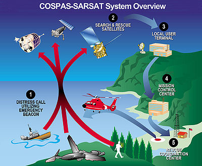 The ground segment of the system consists of:
The space segment of the system consists of:
A SARR/SARP instrument is a small package, typically attached to a satellite that is being launched primarily for another purpose.http://searchandrescue.gsfc.nasa.gov/cospas_sarsat/satellites.html These SARR/SARP are considered a secondary payload onboard satellites with a generally unrelated scientific or telecommunications purpose. See the technical information below for lists of SARR/SARP and their associated satellites.
es called local user terminals (LUT). Each nation's LUTs are monitored by an MCC (Mission Control Centre
), a data distribution clearinghouse that distributes alert information to the various rescue coordination centre
s.
processing. LUTs detecting non-geostationary satellites perform mathematical calculations based on the Doppler
-induced frequency shift received by LEOSAR and MEOSAR satellites as they pass over a beacon transmitting at a fixed frequency. From the mathematical calculations, it is possible to determine both bearing and range with respect to the satellite. The range and bearing are measured from the rate of change of the received frequency, which varies both according to the path of the satellite in space and the rotation of the earth. This allows a computer algorithm to triangulate the position of the beacon. A faster change in the received frequency indicates that the beacon is closer to the satellite's ground track. When the beacon is moving toward or away from the satellite track due to the earth's rotation, that Doppler shift also can be used in the calculation.
The more precise the beacon's transmitting frequency is, the more precise will be the results of the mathematical algorithms in determining location, saving search time. Modern 406 MHz beacons are far more precise than the older, retired beacon designs.
 LEOSAR predates the GEOSAR system, and it complements it. LEOSAR satellites are monitored by 44 LEOLUTs (low Earth orbit local user terminals). The complementary LEOSAR satellites provide periodic coverage of the entire earth with an emphasis on polar regions. The LEOSAR satellites operate in a store-and-forward mode for 406 MHz signals --- they store distress signals and forward them to the next LEOLUT ground station they overfly. The 6-satellite polar-orbit constellation LEOSAR system provides frequent coverage of the poles with approximately 100 minute orbits.
Up until mid-2007, two of the LEOSAR satellites were Cospas satellites provided by the former Soviet Union
and operated by the Russian Federation. However, they were recently taken offline, and now, the American NOAA Polar Operational Environmental Satellites
(POES) and the EUMETSAT MetOp
-A are the only LEOSAR satellites in service. COSPAS satellites characteristically orbit at 1000 km altitude.
The six operational LEOSAR satellites (with both SARR and SARP instruments) are the Sarsat satellites provided by the United States NOAA
and Europe's EUMETSAT. These orbit at an altitude of approximately 850 km. They are:
Operational SARR are installed on the following five geostationary satellites:
SARR undergoing testing or in a role as an on-orbit spare are installed on the following geostationary satellites:
The "406 MHz" distress radiobeacon band is 100 kHz
wide and centered at 406.05 MHz. Individual beacons transmit in assigned 3 kHz
channels. A transmitted distress message is either a 112-bit "short" message or a 144-bit "long" message, both including 49 bits of identification information. If the beacon has a GNSS receiver or position information derived from another local source (such as ship navigation equipment), then that information also is encoded in the transmitted distress message.
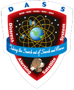 Supporters of the Cospas-Sarsat system are preparing to demonstrate and evaluate a new capability called MEOSAR (Medium Earth Orbit Search and Rescue satellites), consisting of SAR
transponders aboard navigation satellites of Europe, Russia and the United States. In its current (project) form, the U.S. space-segment component is being called the Distress Alerting Satellite System (DASS) by NASA
. MEOSAR will consist of SAR
transponders aboard Europe's Galileo constellation, Russian Glonass spacecraft (Glonass-K No. 1 having been launched on 26 February 2011), and the U.S. GPS
satellite constellation. MEOSAR assets will report signals from Cospas-Sarsat search and rescue
beacon
s in the 406.0–406.1 MHz band. MEOSAR satellites will be able to provide near-instantaneous detection, identification, and location determination of 406 MHz beacons. The beacon can transmit coordinates of its position encoded in the alert message (if the position information is available from an on-board GNSS receiver or another source such as a ship's navigation sensors). Or the position can be determined independently by the receiving LUT by analyzing the frequency-difference-of-arrival (related to Doppler
-induced variations) and/or the time-difference-of-arrival. It is planned that the MEOSAR system will be able to download information back to the distress radiobeacon by encoding "Return Link Service" messages into the Galileo navigation data stream.
Search and rescue
Search and rescue is the search for and provision of aid to people who are in distress or imminent danger.The general field of search and rescue includes many specialty sub-fields, mostly based upon terrain considerations...
(SAR) distress
Distress signal
A distress signal is an internationally recognized means for obtaining help. Distress signals take the form of or are commonly made by using radio signals, displaying a visually detected item or illumination, or making an audible sound, from a distance....
alert detection and information distribution system, established by Canada
Canada
Canada is a North American country consisting of ten provinces and three territories. Located in the northern part of the continent, it extends from the Atlantic Ocean in the east to the Pacific Ocean in the west, and northward into the Arctic Ocean...
, France
France
The French Republic , The French Republic , The French Republic , (commonly known as France , is a unitary semi-presidential republic in Western Europe with several overseas territories and islands located on other continents and in the Indian, Pacific, and Atlantic oceans. Metropolitan France...
, the United States
United States
The United States of America is a federal constitutional republic comprising fifty states and a federal district...
, and the former Soviet Union
Soviet Union
The Soviet Union , officially the Union of Soviet Socialist Republics , was a constitutionally socialist state that existed in Eurasia between 1922 and 1991....
in 1979. It is best known as the system that detects and locates emergency beacons activated by aircraft, ships and backcountry hikers in distress. Over the years many countries have joined the project, either as providers of ground segments or as user states. , 26 countries (Algeria, Argentina, Australia, Brazil, Chile, China (P.R.of), Greece, India
India
India , officially the Republic of India , is a country in South Asia. It is the seventh-largest country by geographical area, the second-most populous country with over 1.2 billion people, and the most populous democracy in the world...
, Indonesia, Italy, Japan, Korea (Rep.of), New Zealand, Nigeria, Norway, Pakistan, Peru, Saudi Arabia, Singapore, South Africa, Spain, Thailand, Turkey, UAE, UK, Vietnam) and two organizations (ITDC of Chinese Taipei and Hong Kong, China) are providers of ground segments, while 11 countries are user states (Cyprus, Denmark, Finland, Germany, Madagascar, Netherlands, Poland, Serbia, Sweden, Switzerland, Tunisia). Cospas-Sarsat is based in Montréal, Québec, Canada, and is headed by Steven Lett of the United States.
The system consists of a ground segment and a space segment:
- Distress radiobeacons to be activated in a life-threatening emergency
- SAR signal repeaters (SARR) and SAR signal processors (SARP) aboard satellites
- Satellite downlink receiving and signal processing stations called LUTs (local user terminals)
- Mission Control CentresMission Control Centre (Cospas-Sarsat)In the field of Search and Rescue, Mission Control Centres are a type of clearinghouse responsible for receiving and distributing distress signal alerts from distress radiobeacons...
that distribute to Rescue Coordination CentreRescue coordination centreA rescue coordination centre or RCC is a primary search and rescue facility in a country that is staffed by supervisory personnel and equipped for coordinating and controlling search and rescue operations....
s distress alert data (particularly beacon location data) generated by the LUTs - Rescue Coordination CentreRescue coordination centreA rescue coordination centre or RCC is a primary search and rescue facility in a country that is staffed by supervisory personnel and equipped for coordinating and controlling search and rescue operations....
s that facilitate coordination of the SAR agency and personnel response to a distress situation.
The space segment of the Cospas-Sarsat system currently consists of SARR instruments aboard 5 geosynchronous satellite
Geosynchronous satellite
A geosynchronous Satellite is a satellite whose orbit on the Earth repeats regularly over points on the Earth over time. If such a satellite's orbit lies over the equator, the orbit is circular and its angular velocity is the same as the earth's, then it is called a geostationary satellite...
s called GEOSARs, and SARR and SARP instruments aboard 6 low-earth polar orbit satellites called LEOSARs.
Background information
The first system satellite 'COSPAS-1' (Kosmos 1383) was launched from Plesetsk CosmodromePlesetsk Cosmodrome
Plesetsk Cosmodrome is a Russian spaceport, located in Arkhangelsk Oblast, about 800 km north of Moscow and approximately 200 km south of Arkhangelsk.-Overview:...
on June 29, 1982. Cospas-Sarsat began tracking the two original types of distress radiobeacons in September, 1982. Specifically, these were:
- EPIRBs (Emergency Position-Indicating Radio Beacons), which signal maritime distress; and
- ELTs (Emergency Locator Transmitters), which signal aircraft distress
More recently, a new type of distress radiobeacon became available (in 2003 in the USA) http://searchandrescue.gsfc.nasa.gov/beacons/index.html:
- PLBs (Personal Locator Beacons), are for personal use and are intended to indicate a person in distress who is away from normal emergency services (i.e. 1-1-21-1-2112 is the principal emergency telephone number that can be dialed free of charge from any telephone or any mobile phone in order to reach emergency services in the European Union , its candidates for accession, members of the EEA agreement, as well as several other countries in the world...
/ 9-1-19-1-19-1-1 is the emergency telephone number for the North American Numbering Plan .It is one of eight N11 codes.The use of this number is for emergency circumstances only, and to use it for any other purpose can be a crime.-History:In the earliest days of telephone technology, prior to the...
)
The four founding countries led development of the 406 MHz marine EPIRB for detection by the system. The EPIRB was seen as a key advancement in SAR technology in the perilous maritime environment. Prior to the founding of Cospas-Sarsat, the aviation community had already been using the 121.5 MHz frequency for distress. ELTs for general aviation
General aviation
General aviation is one of the two categories of civil aviation. It refers to all flights other than military and scheduled airline and regular cargo flights, both private and commercial. General aviation flights range from gliders and powered parachutes to large, non-scheduled cargo jet flights...
were constructed to transmit on 121.5 MHz, a frequency monitored by airliners and other aircraft. Military aircraft beacons were manufactured to transmit at 243.0 MHz, in the band commonly used by military aviation. Early in its history, the Cospas-Sarsat system was engineered to detect beacon-alerts transmitted at 406 MHz, 121.5 MHz and 243.0 MHz. More recently, the Cospas-Sarsat system has been designed to detect only alerts transmitted at 406 MHz (see below). This allows the system to be optimized for the increasingly sophisticated 406 MHz beacons, and avoids problems (including false alerts) from the less-sophisticated legacy 121.5 MHz and 243.0 MHz beacons. Many ELTs include both a 406 MHz transmitter, for satellite detection, and a 121.5 MHz transmitter that can be received by local search crews using direction-finding equipment.
The design of distress radiobeacons as a whole has evolved significantly since 1982; the newest 406 MHz beacons incorporate GPS
Global Positioning System
The Global Positioning System is a space-based global navigation satellite system that provides location and time information in all weather, anywhere on or near the Earth, where there is an unobstructed line of sight to four or more GPS satellites...
receivers; such beacons transmit highly accurate positions of distress almost instantly to SAR agencies via the GEOSAR satellites. The advent of such beacons has created the current motto of SAR agencies --- "Taking the 'Search' out of Search and Rescue." (See MEOSAR below.) http://www.aeromedix.com/aeromedix_articles/plb/index.html
COSPAS (КОСПАС) is an acronym
Acronym and initialism
Acronyms and initialisms are abbreviations formed from the initial components in a phrase or a word. These components may be individual letters or parts of words . There is no universal agreement on the precise definition of the various terms , nor on written usage...
for the Russian words "Cosmicheskaya Sistema Poiska Avariynyh Sudov" (Космическая Система Поиска Аварийных Судов), which translates to "Space System for the Search of Vessels in Distress". SARSAT is an acronym
Acronym and initialism
Acronyms and initialisms are abbreviations formed from the initial components in a phrase or a word. These components may be individual letters or parts of words . There is no universal agreement on the precise definition of the various terms , nor on written usage...
for Search And Rescue Satellite-Aided Tracking.
Cospas-Sarsat is an element of the Global Maritime Distress Safety System
Global Maritime Distress Safety System
The Global Maritime Distress and Safety System is an internationally agreed-upon set of safety procedures, types of equipment, and communication protocols used to increase safety and make it easier to rescue distressed ships, boats and aircraft....
(GMDSS). Automatic-activating EPIRBs are now required on International Convention for the Safety of Life at Sea
International Convention for the Safety of Life at Sea
The International Convention for the Safety of Life at Sea is an international maritime safety treaty. The SOLAS Convention in its successive forms is generally regarded as the most important of all international treaties concerning the safety of merchant ships.- History :The first version of the...
(SOLAS) ships, commercial fishing vessels, and all passenger ships, are designed to transmit to a Rescue Coordination Centre
Rescue coordination centre
A rescue coordination centre or RCC is a primary search and rescue facility in a country that is staffed by supervisory personnel and equipped for coordinating and controlling search and rescue operations....
a vessel identification and an accurate location of the vessel from anywhere in the world.
Phase-out of 121.5 & 243.0 MHz distress radiobeacons
Starting on 1 February 2009, the Cospas-Sarsat System stopped processing signals from the anachronistic 121.5 MHz and 243 MHz beacons. Now only signals from 406 MHz beacons are processed. The switch to 406 MHz is expected to result in a substantial reduction in wasted use of SAR resources on false alerts while simultaneously increasing the responsiveness of the system for real distress cases.System composition
- Distress radiobeacons
- Satellite downlink receiving and signal processing stations called local user terminals (LUT)
- Mission Control CentresMission Control Centre (Cospas-Sarsat)In the field of Search and Rescue, Mission Control Centres are a type of clearinghouse responsible for receiving and distributing distress signal alerts from distress radiobeacons...
that distribute distress alert data generated by the LUTs - Joint Rescue Coordination Centers (also referred to as Rescue Coordination Centres)Joint Rescue Coordination CentersThe National Search and Rescue Plan or National SAR Plan is a policy document of the Federal government of the United States that establishes the responsibilities for search and rescue within the United States....
that coordinate SARSearch and rescueSearch and rescue is the search for and provision of aid to people who are in distress or imminent danger.The general field of search and rescue includes many specialty sub-fields, mostly based upon terrain considerations...
response to a distress situation
The space segment of the system consists of:
- SAR signal processors aboard satellites
Space segment
The Cospas-Sarsat system space segment consists of SARR/SARP instruments aboard:- 5 geosynchronous satellites called GEOSARs, and
- 6 low-earth polar orbit satellites LEOSARs.http://www.cospas-sarsat.org/Status/spaceSegmentStatus.htm
A SARR/SARP instrument is a small package, typically attached to a satellite that is being launched primarily for another purpose.http://searchandrescue.gsfc.nasa.gov/cospas_sarsat/satellites.html These SARR/SARP are considered a secondary payload onboard satellites with a generally unrelated scientific or telecommunications purpose. See the technical information below for lists of SARR/SARP and their associated satellites.
Ground segment
The satellites are monitored by receiving stations equipped with satellite-tracking satellite dishSatellite dish
A satellite dish is a dish-shaped type of parabolic antenna designed to receive microwaves from communications satellites, which transmit data transmissions or broadcasts, such as satellite television.-Principle of operation:...
es called local user terminals (LUT). Each nation's LUTs are monitored by an MCC (Mission Control Centre
Mission Control Centre (Cospas-Sarsat)
In the field of Search and Rescue, Mission Control Centres are a type of clearinghouse responsible for receiving and distributing distress signal alerts from distress radiobeacons...
), a data distribution clearinghouse that distributes alert information to the various rescue coordination centre
Rescue coordination centre
A rescue coordination centre or RCC is a primary search and rescue facility in a country that is staffed by supervisory personnel and equipped for coordinating and controlling search and rescue operations....
s.
Doppler processing
The Cospas-Sarsat system was made possible by DopplerDoppler effect
The Doppler effect , named after Austrian physicist Christian Doppler who proposed it in 1842 in Prague, is the change in frequency of a wave for an observer moving relative to the source of the wave. It is commonly heard when a vehicle sounding a siren or horn approaches, passes, and recedes from...
processing. LUTs detecting non-geostationary satellites perform mathematical calculations based on the Doppler
Doppler effect
The Doppler effect , named after Austrian physicist Christian Doppler who proposed it in 1842 in Prague, is the change in frequency of a wave for an observer moving relative to the source of the wave. It is commonly heard when a vehicle sounding a siren or horn approaches, passes, and recedes from...
-induced frequency shift received by LEOSAR and MEOSAR satellites as they pass over a beacon transmitting at a fixed frequency. From the mathematical calculations, it is possible to determine both bearing and range with respect to the satellite. The range and bearing are measured from the rate of change of the received frequency, which varies both according to the path of the satellite in space and the rotation of the earth. This allows a computer algorithm to triangulate the position of the beacon. A faster change in the received frequency indicates that the beacon is closer to the satellite's ground track. When the beacon is moving toward or away from the satellite track due to the earth's rotation, that Doppler shift also can be used in the calculation.
The more precise the beacon's transmitting frequency is, the more precise will be the results of the mathematical algorithms in determining location, saving search time. Modern 406 MHz beacons are far more precise than the older, retired beacon designs.
LEOSAR
Up until mid-2007, two of the LEOSAR satellites were Cospas satellites provided by the former Soviet Union
Soviet Union
The Soviet Union , officially the Union of Soviet Socialist Republics , was a constitutionally socialist state that existed in Eurasia between 1922 and 1991....
and operated by the Russian Federation. However, they were recently taken offline, and now, the American NOAA Polar Operational Environmental Satellites
Polar Operational Environmental Satellites
The Polar Operational Environmental Satellite project operates a constellation of weather satellites in polar orbits around the Earth. It is a joint effort between the National Oceanic and Atmospheric Administration and the European Organisation for the Exploitation of Meteorological Satellites...
(POES) and the EUMETSAT MetOp
MetOp
MetOp is a series of polar orbiting meteorological satellites operated by the European Organisation for the Exploitation of Meteorological Satellites. The satellites are all part af the EUMETSAT Polar System. It is intended to replace the soon to be retired TIROS network...
-A are the only LEOSAR satellites in service. COSPAS satellites characteristically orbit at 1000 km altitude.
The six operational LEOSAR satellites (with both SARR and SARP instruments) are the Sarsat satellites provided by the United States NOAA
National Oceanic and Atmospheric Administration
The National Oceanic and Atmospheric Administration , pronounced , like "noah", is a scientific agency within the United States Department of Commerce focused on the conditions of the oceans and the atmosphere...
and Europe's EUMETSAT. These orbit at an altitude of approximately 850 km. They are:
- Sarsat-7 instruments aboard NOAA-15NOAA-15NOAA-15 is one of the NASA-provided TIROS series of weather forecasting satellite run by NOAA. It was launched on 13 May 1998, and is currently operational, in a sun-synchronous orbit, 807 km above the Earth, orbiting every 101 minutes...
- Sarsat-8 instruments aboard NOAA-16NOAA-16NOAA-16 is one of the NASA-provided TIROS series of weather forecasting satellite run by NOAA. It was launched on 21 September 2000, and is currently operational, in a sun-synchronous orbit, 849 km above the Earth, orbiting every 102 minutes. It hosts the AMSU, AVHRR and High Resolution...
- Sarsat-9 instruments aboard NOAA-17NOAA-17NOAA-17 is a weather forecasting satellite run by NOAA. It was launched on 24 June 2002, and is currently operational, in a sun-synchronous orbit, 824 km above the Earth, orbiting every 101 minutes. It hosts the AMSU, AVHRR and High Resolution Infrared Radiation Sounder instruments.APT...
- Sarsat-10 instruments aboard NOAA-18NOAA-18NOAA-18 is a weather forecasting satellite run by NOAA. NOAA-N was launched on May 20, 2005, into a sun-synchronous orbit at an altitude of 854 km above the Earth, with an orbital period of 102 minutes. It hosts the AMSU-A, MHS, AVHRR and High Resolution Infrared Radiation Sounder instruments, as...
- Sarsat-11 instruments aboard METOP-AMetOpMetOp is a series of polar orbiting meteorological satellites operated by the European Organisation for the Exploitation of Meteorological Satellites. The satellites are all part af the EUMETSAT Polar System. It is intended to replace the soon to be retired TIROS network...
- Sarsat-12 instruments aboard NOAA-19NOAA-19NOAA-19, designated NOAA-N prior to launch, is the last of the United States National Oceanic and Atmospheric Administration's POES series of weather satellites...
GEOSAR
The GEOSAR satellites are monitored by 16 GEOLUTs (Geostationary Earth Orbit Local User Terminals.) The GEOSAR satellites provide continuous coverage of the entire earth below about 70 degrees latitude with a view toward the equatorial sky. Some locations have poor radio reception toward the GEOSAR satellites and polar regions are not well covered.Operational SARR are installed on the following five geostationary satellites:
- The GOESGoesGoes is a municipality and a city in the southwestern Netherlands in Zuid-Beveland, in the province Zeeland. The city of Goes has approximately 27,000 residents.-History of Goes:...
geostationary satellites (USA) GOES 13GOES 13GOES 13, known as GOES-N before becoming operational, is an American weather satellite which is part of the US National Oceanic and Atmospheric Administration's Geostationary Operational Environmental Satellite system. It was launched in 2006...
at 75° W75th meridian westThe meridian 75° west of Greenwich is a line of longitude that extends from the North Pole across the Arctic Ocean, North America, the Atlantic Ocean, the Caribbean Sea, South America, the Pacific Ocean, the Southern Ocean, and Antarctica to the South Pole....
(the GOES-East role for meteorological purposes) and GOES 11GOES 11GOES 11, known as GOES-L before becoming operational, is an American weather satellite, which is part of the US National Oceanic and Atmospheric Administration's Geostationary Operational Environmental Satellite system...
at 135° W135th meridian westThe meridian 135° west of Greenwich is a line of longitude that extends from the North Pole across the Arctic Ocean, North America, the Pacific Ocean, the Southern Ocean, and Antarctica to the South Pole....
(the GOES-West role for meteorological purposes) - The INSAT-3A geostationary satellite (India) at 93.5° E
- The Meteosat Second Generation (MSG) geostationary satellites (Europe) MSG-1 (also known as Meteosat-8MeteosatThe Meteosat series of satellites are geostationary meteorological satellites operated by EUMETSAT under the Meteosat Transition Programme and the Meteosat Second Generation program....
) at 9.5° E and MSG-2 (also known as Meteosat-9MeteosatThe Meteosat series of satellites are geostationary meteorological satellites operated by EUMETSAT under the Meteosat Transition Programme and the Meteosat Second Generation program....
) fixed over the Prime MeridianPrime MeridianThe Prime Meridian is the meridian at which the longitude is defined to be 0°.The Prime Meridian and its opposite the 180th meridian , which the International Date Line generally follows, form a great circle that divides the Earth into the Eastern and Western Hemispheres.An international...
.
SARR undergoing testing or in a role as an on-orbit spare are installed on the following geostationary satellites:
- The GOESGoesGoes is a municipality and a city in the southwestern Netherlands in Zuid-Beveland, in the province Zeeland. The city of Goes has approximately 27,000 residents.-History of Goes:...
geostationary satellites (USA) GOES 12GOES 12GOES 12, known as GOES-M before becoming operational is an American weather satellite, which is part of the US National Oceanic and Atmospheric Administration's Geostationary Operational Environmental Satellite system. It was launched in 2001, and it is in standby orbit...
at 60° W60th meridian westThe meridian 60° west of Greenwich is a line of longitude that extends from the North Pole across the Arctic Ocean, Greenland, North America, the Atlantic Ocean, South America, the Southern Ocean, and Antarctica to the South Pole....
, GOES 14GOES 14GOES 14, known as GOES-O prior to reaching its operational orbit, is an American weather satellite, which is part of the US National Oceanic and Atmospheric Administration 's Geostationary Operational Environmental Satellite...
at 105° W105th meridian westThe meridian 105° west of Greenwich is a line of longitude that extends from the North Pole across the Arctic Ocean, North America, the Pacific Ocean, the Southern Ocean, and Antarctica to the South Pole....
and GOES 15GOES 15GOES 15, previously known as GOES-P, is an American weather satellite, which will form part of the Geostationary Operational Environmental Satellite system operated by the US National Oceanic and Atmospheric Administration. The spacecraft was constructed by Boeing, and is the last of three GOES...
at 89.5° W90th meridian westThe meridian 90° west of Greenwich is a line of longitude that extends from the North Pole across the Arctic Ocean, North America, the Gulf of Mexico, Central America, the Pacific Ocean, the Southern Ocean, and Antarctica to the South Pole.... - The Electro-L No. 1 geostationary satellite (Russia) at 76° E.
Beacon technical information
Typical rescue beacon radios transmit a 5 watt signal for 0.5 second once every 50 seconds. Most of these terminals sold since 1997 include a GPS receiver so they can report precise GPS lat-lon location. Aircraft distress radiobeacons (ELTs) are automatically activated by g-force switches that detect sudden deceleration during a crash, while maritime radiobeacons (EPIRBs) are normally activated by contact with sea water.The "406 MHz" distress radiobeacon band is 100 kHz
Hertz
The hertz is the SI unit of frequency defined as the number of cycles per second of a periodic phenomenon. One of its most common uses is the description of the sine wave, particularly those used in radio and audio applications....
wide and centered at 406.05 MHz. Individual beacons transmit in assigned 3 kHz
Hertz
The hertz is the SI unit of frequency defined as the number of cycles per second of a periodic phenomenon. One of its most common uses is the description of the sine wave, particularly those used in radio and audio applications....
channels. A transmitted distress message is either a 112-bit "short" message or a 144-bit "long" message, both including 49 bits of identification information. If the beacon has a GNSS receiver or position information derived from another local source (such as ship navigation equipment), then that information also is encoded in the transmitted distress message.
MEOSAR
Search and rescue
Search and rescue is the search for and provision of aid to people who are in distress or imminent danger.The general field of search and rescue includes many specialty sub-fields, mostly based upon terrain considerations...
transponders aboard navigation satellites of Europe, Russia and the United States. In its current (project) form, the U.S. space-segment component is being called the Distress Alerting Satellite System (DASS) by NASA
NASA
The National Aeronautics and Space Administration is the agency of the United States government that is responsible for the nation's civilian space program and for aeronautics and aerospace research...
. MEOSAR will consist of SAR
Search and rescue
Search and rescue is the search for and provision of aid to people who are in distress or imminent danger.The general field of search and rescue includes many specialty sub-fields, mostly based upon terrain considerations...
transponders aboard Europe's Galileo constellation, Russian Glonass spacecraft (Glonass-K No. 1 having been launched on 26 February 2011), and the U.S. GPS
Global Positioning System
The Global Positioning System is a space-based global navigation satellite system that provides location and time information in all weather, anywhere on or near the Earth, where there is an unobstructed line of sight to four or more GPS satellites...
satellite constellation. MEOSAR assets will report signals from Cospas-Sarsat search and rescue
Search and rescue
Search and rescue is the search for and provision of aid to people who are in distress or imminent danger.The general field of search and rescue includes many specialty sub-fields, mostly based upon terrain considerations...
beacon
Beacon
A beacon is an intentionally conspicuous device designed to attract attention to a specific location.Beacons can also be combined with semaphoric or other indicators to provide important information, such as the status of an airport, by the colour and rotational pattern of its airport beacon, or of...
s in the 406.0–406.1 MHz band. MEOSAR satellites will be able to provide near-instantaneous detection, identification, and location determination of 406 MHz beacons. The beacon can transmit coordinates of its position encoded in the alert message (if the position information is available from an on-board GNSS receiver or another source such as a ship's navigation sensors). Or the position can be determined independently by the receiving LUT by analyzing the frequency-difference-of-arrival (related to Doppler
Doppler effect
The Doppler effect , named after Austrian physicist Christian Doppler who proposed it in 1842 in Prague, is the change in frequency of a wave for an observer moving relative to the source of the wave. It is commonly heard when a vehicle sounding a siren or horn approaches, passes, and recedes from...
-induced variations) and/or the time-difference-of-arrival. It is planned that the MEOSAR system will be able to download information back to the distress radiobeacon by encoding "Return Link Service" messages into the Galileo navigation data stream.
Rescue statistics
In 2010, the Cospas-Sarsat system provided emergency-beacon alert data used in rescuing 2,362 people in 641 SAR events. From September 1982 until December 2010, Cospas-Sarsat alert data has helped to rescue 30,713 people in 8,387 SAR events.http://www.cospas-sarsat.org/DocumentsSystemDataDocument/SD33-DEC07_ENG.pdf| Category | 2010 SAR Events |
|---|---|
| Aviation | 20% |
| Maritime | 56% |
| Land | 24% |
| Total | 100% |