

Indian National Satellite System
Encyclopedia
Indian Space Research Organisation
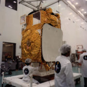
The Indian Space Research Organisation is an independent Indian governmental agency established in 1969 for the research and development of vehicles and activities for the exploration of space within and outside of Earth’s atmosphere. Headquartered in Bangalore...
to satisfy the telecommunications, broadcasting
Broadcasting
Broadcasting is the distribution of audio and video content to a dispersed audience via any audio visual medium. Receiving parties may include the general public or a relatively large subset of thereof...
, meteorology
Meteorology
Meteorology is the interdisciplinary scientific study of the atmosphere. Studies in the field stretch back millennia, though significant progress in meteorology did not occur until the 18th century. The 19th century saw breakthroughs occur after observing networks developed across several countries...
, and search and rescue
Search and rescue
Search and rescue is the search for and provision of aid to people who are in distress or imminent danger.The general field of search and rescue includes many specialty sub-fields, mostly based upon terrain considerations...
operations.
Commissioned in 1983, INSAT is the largest domestic communication system in the Asia Pacific Region. It is a joint venture of the Department of Space
Department of Space
The Department of Space is an Indian government department responsible for administration of the Indian space program.The Indian Space Research Organization is the primary research and development arm of the DoS...
, Department of Telecommunications, India Meteorological Department
India Meteorological Department
The India Meteorological Department , also referred to as the Met Office, is an agency of the Ministry of Earth Sciences of the Government of India. It is the principal agency responsible for meteorological observations, weather forecasting and seismology...
, All India Radio
All India Radio
All India Radio , officially known since 1956 as Akashvani , is the radio broadcaster of India and a division of Prasar Bharati. Established in 1936, it is the sister service of Prasar Bharati's Doordarshan, the national television broadcaster. All India Radio is one of the largest radio networks...
and Doordarshan
DoorDarshan
Doordarshan is an Indian public service broadcaster, a division of Prasar Bharati. It is one of the largest broadcasting organizations in India in terms of the infrastructure of studios and transmitters. Recently, it has also started Digital Terrestrial Transmitters. On September 15, 2009,...
. The overall coordination and management of INSAT system rests with the Secretary-level INSAT Coordination Committee.
INSAT satellites provide transponder
Transponder
In telecommunication, the term transponder has the following meanings:...
s in various bands (C, S, Extended C and Ku) to serve the television and communication needs of India
India
India , officially the Republic of India , is a country in South Asia. It is the seventh-largest country by geographical area, the second-most populous country with over 1.2 billion people, and the most populous democracy in the world...
. Some of the satellites also have the Very High Resolution Radiometer
Advanced Very High Resolution Radiometer
The Advanced Very High Resolution Radiometer is a space-borne sensor embarked on the National Oceanic and Atmospheric Administration family of polar orbiting platforms . AVHRR instruments measure the reflectance of the Earth in 5 relatively wide spectral bands...
(VHRR), CCD
Charge-coupled device
A charge-coupled device is a device for the movement of electrical charge, usually from within the device to an area where the charge can be manipulated, for example conversion into a digital value. This is achieved by "shifting" the signals between stages within the device one at a time...
camera
Camera
A camera is a device that records and stores images. These images may be still photographs or moving images such as videos or movies. The term camera comes from the camera obscura , an early mechanism for projecting images...
s for metrological
Metrology
Metrology is the science of measurement. Metrology includes all theoretical and practical aspects of measurement. The word comes from Greek μέτρον , "measure" + "λόγος" , amongst others meaning "speech, oration, discourse, quote, study, calculation, reason"...
imaging. The satellites also incorporate transponder(s) for receiving distress alert signals for search and rescue missions in the South Asia
South Asia
South Asia, also known as Southern Asia, is the southern region of the Asian continent, which comprises the sub-Himalayan countries and, for some authorities , also includes the adjoining countries to the west and the east...
n and Indian Ocean
Indian Ocean
The Indian Ocean is the third largest of the world's oceanic divisions, covering approximately 20% of the water on the Earth's surface. It is bounded on the north by the Indian Subcontinent and Arabian Peninsula ; on the west by eastern Africa; on the east by Indochina, the Sunda Islands, and...
Region, as ISRO is a member of the Cospas-Sarsat
Cospas-Sarsat
Cospas-Sarsat is an international satellite-based search and rescue distress alert detection and information distribution system, established by Canada, France, the United States, and the former Soviet Union in 1979. It is best known as the system that detects and locates emergency beacons...
programme.
INSAT system
Television
Television is a telecommunication medium for transmitting and receiving moving images that can be monochrome or colored, with accompanying sound...
and radio
Radio
Radio is the transmission of signals through free space by modulation of electromagnetic waves with frequencies below those of visible light. Electromagnetic radiation travels by means of oscillating electromagnetic fields that pass through the air and the vacuum of space...
broadcasting, telecommunication
Telecommunication
Telecommunication is the transmission of information over significant distances to communicate. In earlier times, telecommunications involved the use of visual signals, such as beacons, smoke signals, semaphore telegraphs, signal flags, and optical heliographs, or audio messages via coded...
s and meteorological sectors. It enabled the rapid expansion of TV and modern telecommunication facilities to even the remote areas and off-shore islands. Together, the system provides transponders in C, Extended C and Ku bands for a variety of communication services. Some of the INSATs also carry instruments for meteorological observation and data relay for providing meteorological services. KALPANA-1 is an exclusive meteorological satellite. The satellites are monitored and controlled by Master Control Facilities that exist in Hassan and Bhopal.
Satellites in service
There are currently 11 satellites in service out of 21 which have ever been part of INSAT system.INSAT-2E
It is the last of the five satellites in INSAT-2 series. It carries seventeen C-band and lower extended C-band transponders providing zonal and global coverage with an Effective Isotropic Radiated Power (EIRP) of 36 dBW. It also carries a Very High Resolution Radiometer (VHRR) with imaging capacity in the visible (0.55-0.75 µm), thermal infrared (10.5-12.5 µm) and water vapour (5.7-7.1 µm) channels and provides 2x2 km, 8x8 km and 8x8 km ground resolution respectively. In addition to the above two payloads it has with it a Charge Coupled Device (CCD) cameraCamera
A camera is a device that records and stores images. These images may be still photographs or moving images such as videos or movies. The term camera comes from the camera obscura , an early mechanism for projecting images...
providing 1x1 km ground resolution in the Visible (0.63-0.69 µm), Near Infrared (0.77-0.86 µm) and Shortwave Infrared (1.55-1.70 µm) bands.
INSAT-3A
The multipurpose satellite, INSAT-3A, was launched by ArianeAriane
Ariane is a feminine name. It is a French translation of the Greek name Ariadne. It may refer to:-People:* Princess Ariane of the Netherlands * Ariane Ascaride , French actress and screenwriter...
in April 2003. It is located at 93.5 degree East longitude. The payloads on INSAT-3A are as follows:
- 12 Normal C-band transponders (9 channels provide expanded coverage from Middle East to South East Asia with an EIRP of 38 dBW, 3 channels provide India coverage with an EIRP of 36 dBW and 6 Extended C-band transponders provide India coverage with an EIRP of 36 dBW).
- 6 Ku band transponders provide India coverage with EIRP of 48 dBW.
- A Very High Resolution Radiometer (VHRR) with imaging capacity in the visible (0.55-0.75 µm), thermal infrared (10.5-12.5 µm) and Water Vapour (5.7-7.1 µm) channels, provide 2x2 km, 8x8 km and 8x8 km ground resolutions respectively.
- A CCD camera provides 1x1 km ground resolution, in the visible (0.63-0.69 µm), near infrared (0.77-0.86 µm) and shortwave infrared (1.55-1.70 µm) bands.
- A Data Relay Transponder (DRT) having global receive coverage with a 400 MHz uplink and
4500 MHz downlink for relay of meteorological, hydrological and oceanographic data from unattended land and ocean-based automatic data collection-cum-transmission platforms.
- A Satellite Aided Search and Rescue (SAS&R) SARPSARPStandards And Recommended Practices are technical specifications adopted by the Council of ICAO in accordance with Article 37 of the Convention on International Civil Aviation in order to achieve "the highest practicable degree of uniformity in regulations, standards, procedures and organization...
payload having global receive coverage with 406 MHz uplink and 4500 MHz downlink with India coverage, for relay of signals from distress beacons in sea, air or land. See also Cospas-SarsatCospas-SarsatCospas-Sarsat is an international satellite-based search and rescue distress alert detection and information distribution system, established by Canada, France, the United States, and the former Soviet Union in 1979. It is best known as the system that detects and locates emergency beacons...
.
INSAT-3C
Launched in January 2002, INSAT-3C is positioned at 74 degree East longitude74th meridian east
The meridian 74° east of Greenwich is a line of longitude that extends from the North Pole across the Arctic Ocean, Asia, the Indian Ocean, the Southern Ocean, and Antarctica to the South Pole....
. INSAT-3C payloads include 24 Normal C-band transponders providing an EIRP of 37 dBW, six Extended C-band transponders with EIRP of 37 dBW, two S-band transponders to provide BSS services with 42 dBW EIRP and an MSS payload similar to that on INSAT-3B. All the transponders provide coverage over India.
INSAT-3E
Launched in September 2003, INSAT-3E is positioned at 55 degree East longitude55th meridian east
The meridian 55° east of Greenwich is a line of longitude that extends from the North Pole across the Arctic Ocean, Europe, Asia, the Indian Ocean, the Southern Ocean, and Antarctica to the South Pole....
and carries 24 Normal C-band transponders provide an edge of coverage EIRP of 37 dBW over India and 12 Extended C-band transponders provide an edge of coverage EIRP of 38 dBW over India.
KALPANA-1
KALPANA-1Kalpana-1
Kalpana-1 is the first dedicated meteorological satellite launched by Indian Space Research Organisation using Polar Satellite Launch Vehicle on 2002-09-12. This was the first satellite launched by the PSLV into the Geostationary orbit....
is an exclusive meteorological satellite launched by PSLV in September 2002. It carries VHRR and DRT payloads to provide meteorological services. It is located at 74 degree East longitude
74th meridian east
The meridian 74° east of Greenwich is a line of longitude that extends from the North Pole across the Arctic Ocean, Asia, the Indian Ocean, the Southern Ocean, and Antarctica to the South Pole....
.
GSAT-2
Launched by the second flight of GSLV in May 2003, GSAT-2 is located at 48 degree East longitude48th meridian east
The meridian 48° east of Greenwich is a line of longitude that extends from the North Pole across the Arctic Ocean, Europe, Asia, Africa, the Indian Ocean, Madagascar, the Southern Ocean, and Antarctica to the South Pole....
and carries four Normal C-band transponders to provide 36 dBW EIRP with India coverage, two Ku band transponders with 42 dBW EIRP over India and an MSS payload similar to those on INSAT-3B and INSAT-3C.
EDUSAT
Configured for audio-visual medium employing digital interactive classroom lessons and multimedia content, EDUSAT was launched by GSLV in September 2004. Its transponders and their ground coverage are specially configured to cater to the educational requirements. The satellite carries a Ku band transponder covering the Indian mainland region with 50 dBW EIRP, five Ku band spot beam transponders for South, West, Central, North and North East regional coverage with 55 dBW EIRP and six Extended C-band transponders with India coverage with 37 dBW EIRP. EDUSAT is positioned at 74 degree East longitude74th meridian east
The meridian 74° east of Greenwich is a line of longitude that extends from the North Pole across the Arctic Ocean, Asia, the Indian Ocean, the Southern Ocean, and Antarctica to the South Pole....
and is collocated with KALPANA-1 and INSAT-3
INSAT-4A
Launched in December 2005 by the European ArianeAriane
Ariane is a feminine name. It is a French translation of the Greek name Ariadne. It may refer to:-People:* Princess Ariane of the Netherlands * Ariane Ascaride , French actress and screenwriter...
launch vehicle, INSAT-4A is positioned at 83 degree East longitude
83rd meridian east
The meridian 83° east of Greenwich is a line of longitude that extends from the North Pole across the Arctic Ocean, Asia, the Indian Ocean, the Southern Ocean, and Antarctica to the South Pole....
along with INSAT-2E and INSAT-3B. It carries 12 Ku band 36 MHz bandwidth transponders employing 140 W TWTAs to provide an EIRP of 52 dBW at the edge of coverage polygon with footprint covering Indian main land and 12 C-band 36 MHz bandwidth transponders provide an EIRP of 39 dBW at the edge of coverage with expanded radiation patterns encompassing Indian geographical boundary, area beyond India in southeast and northwest regions. Tata Sky
Tata Sky
TATA Sky is a direct broadcast satellite television provider in India, using MPEG-2 digital compression technology, transmitting using INSAT 4A at 83.0°E....
, a joint venture
Joint venture
A joint venture is a business agreement in which parties agree to develop, for a finite time, a new entity and new assets by contributing equity. They exercise control over the enterprise and consequently share revenues, expenses and assets...
between the TATA Group
Tata Group
Tata Group is an Indian multinational conglomerate company headquartered in Mumbai, Maharashtra, India. Tata Group is one of the largest companies in India by market capitalization and revenue. It has interests in communications and information technology, engineering, materials, services, energy,...
and STAR
STAR TV
Satellite Television Asia Region is an Asian TV service owned by Rupert Murdoch's News Corporation. It is headquartered in Hong Kong, with regional offices in mainland China, Taiwan....
uses INSAT-4A for distributing their Direct To Home Digital Television services across India.
INSAT-4B
It was launched in March 2007 by the European ArianeAriane
Ariane is a feminine name. It is a French translation of the Greek name Ariadne. It may refer to:-People:* Princess Ariane of the Netherlands * Ariane Ascaride , French actress and screenwriter...
launch vehicle. Configured with payloads identical to that of INSAT-4A, INSAT-4B carries 12 Ku band and 12 C-band transponders to provide EIRP of 52 dBW and 39 dBW respectively. Two Tx/Rx dual grid offset fed shaped beam reflectors of 2.2 m diameter for Ku band and 2 m diameter for C-band are used. INSAT-4B augments the high power transponder capacity over India in Ku band and over a wider region in C-band. It is co-located with INSAT-3A at 93.5 degree E longitude.
The national space agency Indian Space Research Organisation (ISRO)
Indian Space Research Organisation
The Indian Space Research Organisation is an independent Indian governmental agency established in 1969 for the research and development of vehicles and activities for the exploration of space within and outside of Earth’s atmosphere. Headquartered in Bangalore...
has allotted nearly seven Ku band transponders to Sun Direct; a DTH service provider from South India, and the other five to Doordarshan's DD Direct Plus. 12 transponders in the C band are for TV, radio and telecommunication purposes
Glitch in INSAT 4B
On July 7, 2010, ISRO has reported a glitch in the operation of INSAT 4B. Power was not flowing from one of the solar panels to the satellite bus from July 7 night, which led to switching off 50 per cent of the transponders on board the satellite. ISRO engineers said the glitch could have developed because a relay that transferred power from the solar panel to the satellite bus could have “misbehaved” or the wires connecting the panel to the satellite could have snapped.
China-Stuxnet Connection
American cyber warfare expert Jeffrey Carr
Jeffrey Carr
Jeffrey Carr is a cybersecurity analyst and expert. He lives in Seattle Washington. He is founder and CEO of Taia Global inc. He is also the founder and principal investigator of Project Grey Goose, an open source investigation into cyber conflicts including the Russian cyber attacks on Georgia,...
, who specialises in investigations of cyber attacks against government, mentioned in his interview with The Times of India, that the reason for this power glitch may have been an infection by the sophisticated Stuxnet worm. He attributed the development of Stuxnet worm most likely to Government of China which had the necessary sophistication to develop the bug and would gain the maximum by failure of Indian satellite. He also pointed out that Stuxnet was discovered just a month before the Indian satellite was hit by the power glitch, the reason for which still remains unknown. ISRO uses the same Siemens software that was targeted by Stuxnet.
INSAT-4CR
INSAT-4CR was launched on 2 September 2007 by GSLV-F04. It is a replacement satellite of INSAT-4C which was lost when GSLV-F02 failed and had to be destroyed on its course. It carries 12 Ku band 36 MHz bandwidth transponders employing 140 W TWTAs to provide an Effective Isotropic Radiated Power of 51.5 dBW at Edge of Coverage with footprint covering Indian mainland. It also incorporates a Ku band Beacon as an aid to tracking the satellite.On 8 September 2007 ISRO reported the satellite had reached a near geosynchronous orbit, and would be stabilized in its intended orbital position of 74 degrees E longitude
74th meridian east
The meridian 74° east of Greenwich is a line of longitude that extends from the North Pole across the Arctic Ocean, Asia, the Indian Ocean, the Southern Ocean, and Antarctica to the South Pole....
by 15 September. The satellite is designed for a mission life in of ten years. There were reports that the mission life of the satellite had decreased by five years as the thrusters had to burn this much fuel to restore the satellite to its correct orbit. However, the ISRO later refuted this claim dismissing it as false.
This satellite is used by Airtel Digital TV
Airtel digital TV
Airtel digital TV is an Indian direct broadcast satellite service provider owned and operated by Bharti Airtel. Its satellite service, launched on 2008, transmits digital satellite television and audio to households in India. It uses MPEG-4 digital compression with DVB-S2 technology, transmitting...
and Sun Direct DTH
Sun Direct DTH
Sun Direct is an Indian direct broadcast satellite service provider. Its satellite service, launched on 2005, transmits digital satellite television and audio to households in India. Sun Direct uses MPEG-4 digital compression technology, transmitting on INSAT 4B at 93.5°E. and MEASAT-3 at 91.5°E...
.