
First level NUTS of the European Union
Encyclopedia
The Nomenclature of Territorial Units for Statistics
, (NUTS, for the French nomenclature d'unités territoriales statistiques), is a geocode
standard
for referencing the administrative divisions of countries for statistical purposes. The standard was developed by the European Union
.
There are three levels of NUTS defined, with two levels of local administrative unit
s (LAUs) below. Not all countries have every level of division, depending on their size. One of the most extreme cases is Luxembourg, which has only LAUs; the three NUTS divisions each correspond to the entire country itself.
Below are the first level NUTS regions of the European Union.
Nomenclature of Territorial Units for Statistics
The Nomenclature of Territorial Units for Statistics or Nomenclature of Units for Territorial Statistics is a geocode standard for referencing the subdivisions of countries for statistical purposes...
, (NUTS, for the French nomenclature d'unités territoriales statistiques), is a geocode
Geocode
GEOCODE is a standardized all-natural number representation format specification for geospatial coordinate measurements that provide details of the exact location of geospatial point at, below, or above the surface of the earth at a specified moment of time.Geocode is patented under US Patents...
standard
Standardization
Standardization is the process of developing and implementing technical standards.The goals of standardization can be to help with independence of single suppliers , compatibility, interoperability, safety, repeatability, or quality....
for referencing the administrative divisions of countries for statistical purposes. The standard was developed by the European Union
European Union
The European Union is an economic and political union of 27 independent member states which are located primarily in Europe. The EU traces its origins from the European Coal and Steel Community and the European Economic Community , formed by six countries in 1958...
.
There are three levels of NUTS defined, with two levels of local administrative unit
Local administrative unit
Generally, a local administrative unit is a low level administrative division of a country, ranked below a province, region, or state. Not all countries describe their locally governed areas this way, but it can be descriptively applied anywhere to refer to counties, municipalities, etc.In the...
s (LAUs) below. Not all countries have every level of division, depending on their size. One of the most extreme cases is Luxembourg, which has only LAUs; the three NUTS divisions each correspond to the entire country itself.
Below are the first level NUTS regions of the European Union.
| Code | Name | Corresponding second level subdivisions | Map | |||
|---|---|---|---|---|---|---|
| AT |  Austria Austria |
|||||
| AT1 | East Austria | Burgenland Burgenland Burgenland is the easternmost and least populous state or Land of Austria. It consists of two Statutarstädte and seven districts with in total 171 municipalities. It is 166 km long from north to south but much narrower from west to east... , Lower Austria Lower Austria Lower Austria is the northeasternmost state of the nine states in Austria. The capital of Lower Austria since 1986 is Sankt Pölten, the most recently designated capital town in Austria. The capital of Lower Austria had formerly been Vienna, even though Vienna is not officially part of Lower Austria... , Vienna Vienna Vienna is the capital and largest city of the Republic of Austria and one of the nine states of Austria. Vienna is Austria's primary city, with a population of about 1.723 million , and is by far the largest city in Austria, as well as its cultural, economic, and political centre... |
 |
|||
| AT2 | South Austria | Carinthia Carinthia (state) Carinthia is the southernmost Austrian state or Land. Situated within the Eastern Alps it is chiefly noted for its mountains and lakes.The main language is German. Its regional dialects belong to the Southern Austro-Bavarian group... , Styria Styria (state) Styria is a state or Bundesland, located in the southeast of Austria. In area it is the second largest of the nine Austrian federated states, covering 16,401 km². It borders Slovenia as well as the other Austrian states of Upper Austria, Lower Austria, Salzburg, Burgenland, and Carinthia. ... |
||||
| AT3 | West Austria | Upper Austria Upper Austria Upper Austria is one of the nine states or Bundesländer of Austria. Its capital is Linz. Upper Austria borders on Germany and the Czech Republic, as well as on the other Austrian states of Lower Austria, Styria, and Salzburg... , Salzburg Salzburg (state) Salzburg is a state or Land of Austria with an area of 7,156 km2, located adjacent to the German border. It is also known as Salzburgerland, to distinguish it from its capital city, also named Salzburg... , Tyrol Tyrol (state) Tyrol is a state or Bundesland, located in the west of Austria. It comprises the Austrian part of the historical region of Tyrol.The state is split into two parts–called North Tyrol and East Tyrol–by a -wide strip of land where the state of Salzburg borders directly on the Italian province of... , Vorarlberg Vorarlberg Vorarlberg is the westernmost federal-state of Austria. Although it is the second smallest in terms of area and population , it borders three countries: Germany , Switzerland and Liechtenstein... |
||||
| BE |  Belgium Belgium |
|||||
| BE1 | Brussels Capital Region Brussels Brussels , officially the Brussels Region or Brussels-Capital Region , is the capital of Belgium and the de facto capital of the European Union... |
Brussels Capital Region Brussels Brussels , officially the Brussels Region or Brussels-Capital Region , is the capital of Belgium and the de facto capital of the European Union... |
 |
|||
| BE2 | Flemish Region Flemish Region The Flemish Region is one of the three official regions of the Kingdom of Belgium—alongside the Walloon Region and the Brussels-Capital Region. Colloquially, it is usually simply referred to as Flanders, of which it is the institutional iteration within the context of the Belgian political system... |
Antwerp Antwerp (province) Antwerp is the northernmost province both of the Flemish Region, also called Flanders, and of Belgium. It borders on the Netherlands and the Belgian provinces of Limburg, Flemish Brabant and East Flanders. Its capital is Antwerp which comprises the Port of Antwerp... , Limburg Limburg (Belgium) Limburg is the easternmost province of modern Flanders, which is one of the three main political and cultural sub-divisions of modern Belgium. It is located west of the river Meuse . It borders on the Dutch provinces of North Brabant and Limburg and the Belgian provinces of Liège, Flemish Brabant... , East Flanders East Flanders East Flanders is a province of Flanders, one of the three regions of Belgium. It borders on the Netherlands and in Belgium on the provinces of Antwerp, Flemish Brabant , of Hainaut and of West Flanders... , Flemish Brabant Flemish Brabant Flemish Brabant is a province of Flanders, one of the three regions of Belgium. It borders on the Belgian provinces of Antwerp, Limburg, Liège, Walloon Brabant, Hainaut and East Flanders. Flemish Brabant also completely surrounds the Brussels-Capital Region. Its capital is Leuven... , West Flanders |
||||
| BE3 | Walloon Region Walloon Region The Walloon Region, commonly called Wallonia, is one of the three federal Regions of Belgium, and its capital is Namur. It comprises, as defined by Article 5 of the Constitution of Belgium, the provinces of Walloon Brabant, Hainaut, Liège, Luxembourg and Namur... |
Walloon Brabant Walloon Brabant Walloon Brabant is a province of Wallonia in Belgium. It borders on the province of Flemish Brabant and the provinces of Liège, Namur and Hainaut . Its capital is Wavre... , Hainaut, Liège Liège (province) Liège is the easternmost province of Belgium and belongs to the Walloon Region. It is an area of French and German ethnicity. It borders on the Netherlands, Germany, Luxembourg, and in Belgium the provinces of Luxembourg, Namur, Walloon Brabant , and those of Flemish Brabant and Limburg . Its... , Luxembourg Luxembourg (Belgium) Luxembourg is the southernmost province of Wallonia and of Belgium. It borders on the Grand Duchy of Luxembourg, France, and the Belgian provinces of Namur and Liège. Its capital is Arlon, in the south-east of the province.It has an area of 4,443 km², making it the largest Belgian province... , Namur Namur (province) Namur is a province of Wallonia, one of the three regions of Belgium. It borders on the Walloon provinces of Hainaut, Walloon Brabant, Liège and Luxembourg in Belgium, and on France. Its capital is the city of Namur... |
||||
| BG |  Kingdom of Bulgaria Kingdom of Bulgaria |
|||||
| BG3 | Severna I Iztochna | Severozapaden Severozapaden Severozepaden is a region of Bulgaria. The capital is the city of Pleven. The region has the lowest-ranked economy in Bulgaria and the European Union, with a GDP of € 6,400 or 25.6 % of EU27 average . It includes five administrative divisions or oblasts: Vidin Province, Vratsa Province, Montana... , Severen tsentralen Severen tsentralen Severen Tsentralen is a planning region of Bulgaria, encompassing five Bulgarian provinces: Ruse, Veliko Tarnovo, Gabrovo, Targovishte and Razgrad.The region is mostly inhabited by Bulgarians, Turkish and Romani people... , Severoiztochen Severoiztochen Severoiztochen is a planning region in Bulgaria.The region includes four provinces: Silistra Province, Varna Province, Shumen Province and Dobrich Province.... , Yugoiztochen Yugoiztochen Yugoiztochen is one of Bulgaria's planning regions. The capital is Burgas. It includes: Burgas Province, Sliven Province, Yambol Province and Stara Zagora Province.... |
 |
|||
| BG4 | Yugozapadna I Yuzhna Tsentralna | Yugozapaden Yugozapaden Yugozapaden is a planning region in Bulgaria. The capital, also the national capital, is Sofia. It includes: Blagoevgrad Province, Sofia city, Sofia Province, Pernik Province and Kyustendil Province.... , Yuzhen tsentralen Yuzhen tsentralen Yuzhen tsentralen is a Bulgarian region. The capital is Plovdiv, the second-largest city in Bulgaria. It includes five Bulgarians provinces : Plovdiv Province, Pazardzhik Province, Smolyan Province, Kardzhali Province and Haskovo Province.... |
||||
| CY NUTS of Cyprus In the NUTS codes of Cyprus , the three levels are:-Local administrative units:Below the NUTS levels, the two LAU levels are:... |  Cyprus Cyprus |
|||||
| CY0 | Cyprus Cyprus Cyprus , officially the Republic of Cyprus , is a Eurasian island country, member of the European Union, in the Eastern Mediterranean, east of Greece, south of Turkey, west of Syria and north of Egypt. It is the third largest island in the Mediterranean Sea.The earliest known human activity on the... |
Cyprus Cyprus Cyprus , officially the Republic of Cyprus , is a Eurasian island country, member of the European Union, in the Eastern Mediterranean, east of Greece, south of Turkey, west of Syria and north of Egypt. It is the third largest island in the Mediterranean Sea.The earliest known human activity on the... |
|
|||
| CZ |  Czech Republic Czech Republic |
|||||
| CZ0 | Czech Republic Czech Republic The Czech Republic is a landlocked country in Central Europe. The country is bordered by Poland to the northeast, Slovakia to the east, Austria to the south, and Germany to the west and northwest.... |
Prague Prague Prague is the capital and largest city of the Czech Republic. Situated in the north-west of the country on the Vltava river, the city is home to about 1.3 million people, while its metropolitan area is estimated to have a population of over 2.3 million... , Central Bohemia Central Bohemian Region Central Bohemian Region is an administrative unit of the Czech Republic, located in the central part of its historical region of Bohemia. Its administrative center is placed in the Czech capital Prague , which lies in the center of the region... , Southwest, Northwest, Northeast, Southeast, Central Moravia, Moravia-Silesia Moravian-Silesian Region Moravian-Silesian Region , or Moravo-Silesian Region, is one of 14 administrative Regions of the Czech Republic, until May 2001 it was formerly called the Ostrava Region . The region is located in the north-eastern part of its historical region of Moravia and in most of the Czech part of the... |
 |
|||
| DE NUTS of Germany In the NUTS codes of Germany , the three levels are:-DE1 :In the NUTS codes of Germany , the three levels are:-DE1 :... |  Germany Germany |
|||||
| DE1 | Baden-Württemberg Baden-Württemberg Baden-Württemberg is one of the 16 states of Germany. Baden-Württemberg is in the southwestern part of the country to the east of the Upper Rhine, and is the third largest in both area and population of Germany's sixteen states, with an area of and 10.7 million inhabitants... |
Stuttgart Stuttgart (region) Stuttgart is one of the four administrative districts of Baden-Württemberg, Germany, located in the north-east of the state of Baden-Württemberg, in the southwestern part of Germany.It is sub-divided into the three regions Heilbronn-Franken, Ostwürttemberg, Stuttgart.- External links :*... , Karlsruhe Karlsruhe (region) Karlsruhe is one of the four administrative districts of Baden-Württemberg, Germany, located in the north-west of the state. It is subdivided into the three regional associations : Mittlerer Oberrhein , Rhein-Neckar and Nordschwarzwald .- External links :*... , Freiburg Freiburg (region) Freiburg is one of the four Regierungsbezirke of Baden-Württemberg, Germany, located in the south-west of the country. It covers the Black Forest hills as well as the Rhine valley. It's sub-divided into the three regions Hochrhein-Bodensee, Schwarzwald-Baar-Heuberg and Südlicher Oberrhein.-... , Tübingen Tübingen (region) Tübingen is one of the four Administrative Regions of Baden-Württemberg, Germany, located in the south-east of the country. It covers most of the German shore of Lake Constance , and also the beginning of the Danube River valley. It is sub-divided into the three regions : Neckar-Alb, Donau-Iller... |
 |
|||
| DE2 | Bavaria Bavaria Bavaria, formally the Free State of Bavaria is a state of Germany, located in the southeast of Germany. With an area of , it is the largest state by area, forming almost 20% of the total land area of Germany... |
Upper Bavaria Upper Bavaria Upper Bavaria is one of the seven administrative regions of Bavaria, Germany.- Geography :Upper Bavaria is located in the southern portion of Bavaria, and is centered around the city of Munich. It is subdivided into four regions : Ingolstadt, Munich, Bayerisches Oberland , and Südostoberbayern... , Lower Bavaria Lower Bavaria Lower Bavaria is one of the seven administrative regions of Bavaria, Germany, located in the east of the state.- Geography :Lower Bavaria is subdivided into two regions - Landshut and Donau-Wald. Recent election results mark it as the most conservative part of Germany, generally giving huge... , Upper Palatinate Upper Palatinate The Upper Palatinate is one of the seven administrative regions of Bavaria, Germany, located in the east of Bavaria.- History :The region took its name first in the early 16th century, because it was by the Treaty of Pavia one of the main portions of the territory of the Wittelsbach Elector... , Upper Franconia Upper Franconia Upper Franconia is a Regierungsbezirk of the state of Bavaria, southern Germany. It forms part of the historically significant region of Franconia , all now part of the German Federal State of Bayern .With more than 200 independent breweries which brew... , Middle Franconia Middle Franconia Middle Franconia is one of the three administrative regions of Franconia in Bavaria, Germany. It is in the west of Bavaria and adjoins the state of Baden-Württemberg... , Lower Franconia Lower Franconia Lower Franconia is one of the three administrative regions of Franconia in Bavaria , Germany .... , Swabia Swabia (administrative region) Swabia is one of the seven administrative regions of Bavaria, Germany.- Geography :Swabia is located in southwest Bavaria. It was formed out of the part of the historic region of Swabia which was annexed by Bavaria in 1803. It was once formally ruled by dukes of the Hohenstaufen dynasty. During... |
||||
| DE3 | Berlin Berlin Berlin is the capital city of Germany and is one of the 16 states of Germany. With a population of 3.45 million people, Berlin is Germany's largest city. It is the second most populous city proper and the seventh most populous urban area in the European Union... |
Berlin | ||||
| DE4 | Brandenburg Brandenburg Brandenburg is one of the sixteen federal-states of Germany. It lies in the east of the country and is one of the new federal states that were re-created in 1990 upon the reunification of the former West Germany and East Germany. The capital is Potsdam... |
Brandenburg-Northeast Brandenburg-Northeast Brandenburg-Northeast is a NUTS-2 Regions of Germany, encompassing the northeastern portion of the state of Brandenburg.... , Brandenburg-Southwest Brandenburg-Southwest Brandenburg-Northeast is a NUTS-2 Regions of Germany, encompassing the southwestern portion of the state of Brandenburg.... |
||||
| DE5 | Bremen (state) Bremen (state) The Free Hanseatic City of Bremen is the smallest of Germany's 16 states. A more informal name, but used in some official contexts, is Land Bremen .-Geography:... |
Bremen (state) Bremen (state) The Free Hanseatic City of Bremen is the smallest of Germany's 16 states. A more informal name, but used in some official contexts, is Land Bremen .-Geography:... |
||||
| DE6 | Hamburg Hamburg -History:The first historic name for the city was, according to Claudius Ptolemy's reports, Treva.But the city takes its modern name, Hamburg, from the first permanent building on the site, a castle whose construction was ordered by the Emperor Charlemagne in AD 808... |
Hamburg Hamburg -History:The first historic name for the city was, according to Claudius Ptolemy's reports, Treva.But the city takes its modern name, Hamburg, from the first permanent building on the site, a castle whose construction was ordered by the Emperor Charlemagne in AD 808... |
||||
| DE7 | Hessen | Darmstadt Darmstadt (region) Darmstadt is one of the three Regierungsbezirke of Hesse, Germany, located in the south of the state.- External links :*... , Gießen Gießen (region) Gießen is one of the three Regierungsbezirke of Hesse, Germany, located in the middle of the state.- External links :*... , Kassel Kassel (region) Kassel is one of the three Regierungsbezirke of Hesse, Germany, located in the north of the state. It was created in 1866 when Prussia annexed the area to form the new province Hesse-Nassau... |
||||
| DE8 | Mecklenburg-Vorpommern | Mecklenburg-Vorpommern | ||||
| DE9 | Lower Saxony Lower Saxony Lower Saxony is a German state situated in north-western Germany and is second in area and fourth in population among the sixteen states of Germany... |
Braunschweig Braunschweig (region) Brunswick is one of the four former administrative regions of Lower Saxony, Germany, located in the southeast of the state. The region covers roughly the area of the former state of Brunswick-Lüneburg... , Hanover Hanover (region) Hanover was a Regierungsbezirk of the Prussian Province of Hanover and of Lower Saxony, Germany, that existed from 1885 until 2004. It was located in the south of the state around the city of Hanover, its capital.... , Lüneburg Lüneburg (region) Lüneburg was one of the four Regierungsbezirke of Lower Saxony, Germany, located in the north of the federal state between the three cities Bremen, Hamburg and Hanover.... , Weser-Ems Weser-Ems Weser-Ems was the most westerly of the four Regierungsbezirke of Lower Saxony, Germany, bordering the Dutch provinces of Groningen, Drenthe and Overijssel... |
||||
| DEA | North Rhine-Westphalia North Rhine-Westphalia North Rhine-Westphalia is the most populous state of Germany, with four of the country's ten largest cities. The state was formed in 1946 as a merger of the northern Rhineland and Westphalia, both formerly part of Prussia. Its capital is Düsseldorf. The state is currently run by a coalition of the... |
Düsseldorf Düsseldorf (region) Düsseldorf is one of the five Regierungsbezirke of North Rhine-Westphalia, Germany, located in the north-west of the country. It covers the western part of the Ruhr Area, as well as the Niederrheinische Tiefebene, the lower Rhine area. It is the most populated of all German administrative areas of... , Cologne Cologne (region) Cologne is one of the five governmental districts of the German Federal State of North Rhine-Westphalia. It is located in the south-west of that state and covers the hills of the Eifel as well as the Bergisches Land.... , Münster Münster (region) Münster is one of the five Regierungsbezirke of North Rhine-Westphalia, Germany, located in the north of the state, and named after the city of Münster. It includes the area which in medieval times was known as the Dreingau.... , Detmold Detmold (region) The Regierungsbezirk Detmold is one of the five Regierungsbezirke of North Rhine-Westphalia, Germany, located in the north-east of the state... , Arnsberg Arnsberg (region) Arnsberg is one of the five Regierungsbezirke of North Rhine-Westphalia, Germany, located in the south-east of the country. It covers the Sauerland hills as well as the east part of the Ruhr area.... |
||||
| DEB | Rhineland-Palatinate Rhineland-Palatinate Rhineland-Palatinate is one of the 16 states of the Federal Republic of Germany. It has an area of and about four million inhabitants. The capital is Mainz. English speakers also commonly refer to the state by its German name, Rheinland-Pfalz .... |
Koblenz Koblenz (region) Koblenz was one of the three Regierungsbezirke of Rhineland-Palatinate, Germany, located in the north-east of the state.The region was created in 1815 as part of the Prussian Rhineland, becoming part of the new state of Rhineland-Palatinate in 1946.... , Trier Trier (region) Trier was one of the three Regierungsbezirke of Rhineland-Palatinate, Germany, located in the west of the state.The region was created in 1815 as part of the Prussian Rhineland. Before World War I parts of Saarland were administered within Regierungsbezirk Trier... , Rheinhessen-Pfalz Rheinhessen-Pfalz Rheinhessen-Pfalz was one of the three Regierungsbezirke of Rhineland-Palatinate, Germany, located in the south of the state... |
||||
| DEC | Saarland Saarland Saarland is one of the sixteen states of Germany. The capital is Saarbrücken. It has an area of 2570 km² and 1,045,000 inhabitants. In both area and population, it is the smallest state in Germany other than the city-states... |
Saarland Saarland Saarland is one of the sixteen states of Germany. The capital is Saarbrücken. It has an area of 2570 km² and 1,045,000 inhabitants. In both area and population, it is the smallest state in Germany other than the city-states... |
||||
| DED | Saxony Saxony The Free State of Saxony is a landlocked state of Germany, contingent with Brandenburg, Saxony Anhalt, Thuringia, Bavaria, the Czech Republic and Poland. It is the tenth-largest German state in area, with of Germany's sixteen states.... |
Chemnitz Chemnitz (region) thumb|right|200px|none|The [[:de:Regierungsbezirk Chemnitz|Regierungsbezirk Chemnitz]] before August 2008Chemnitz is one of the three Direktionsbezirke of the Free State of Saxony, Germany, located in the south-west of the state... , Dresden Dresden (region) Dresden is one of the three Direktionsbezirke of the Free State of Saxony, Germany, located in the east of the state. It coincides with the Planungsregionen Oberlausitz-Niederschlesien and Oberes Elbtal/Osterzgebirge.-History:... , Leipzig Leipzig (region) Leipzig is one of the three Direktionsbezirke of the Free State of Saxony, Germany, located in the north-west of the state. It coincides with the Planungsregion Westsachsen.-History:... |
||||
| DEE | Saxony-Anhalt Saxony-Anhalt Saxony-Anhalt is a landlocked state of Germany. Its capital is Magdeburg and it is surrounded by the German states of Lower Saxony, Brandenburg, Saxony, and Thuringia.Saxony-Anhalt covers an area of... |
Saxony-Anhalt Saxony-Anhalt Saxony-Anhalt is a landlocked state of Germany. Its capital is Magdeburg and it is surrounded by the German states of Lower Saxony, Brandenburg, Saxony, and Thuringia.Saxony-Anhalt covers an area of... |
||||
| DEF | Schleswig-Holstein Schleswig-Holstein Schleswig-Holstein is the northernmost of the sixteen states of Germany, comprising most of the historical duchy of Holstein and the southern part of the former Duchy of Schleswig... |
Schleswig-Holstein Schleswig-Holstein Schleswig-Holstein is the northernmost of the sixteen states of Germany, comprising most of the historical duchy of Holstein and the southern part of the former Duchy of Schleswig... |
||||
| DEG | Thuringia Thuringia The Free State of Thuringia is a state of Germany, located in the central part of the country.It has an area of and 2.29 million inhabitants, making it the sixth smallest by area and the fifth smallest by population of Germany's sixteen states.... |
Thuringia Thuringia The Free State of Thuringia is a state of Germany, located in the central part of the country.It has an area of and 2.29 million inhabitants, making it the sixth smallest by area and the fifth smallest by population of Germany's sixteen states.... |
||||
| DK |  Denmark Denmark |
|||||
| DK0 | Denmark Denmark Denmark is a Scandinavian country in Northern Europe. The countries of Denmark and Greenland, as well as the Faroe Islands, constitute the Kingdom of Denmark . It is the southernmost of the Nordic countries, southwest of Sweden and south of Norway, and bordered to the south by Germany. Denmark... |
Hovedstaden Region Hovedstaden The Capital Region of Denmark is an administrative region of Denmark established on January 1, 2007 as part of the 2007 Danish Municipal Reform, which replaced the traditional counties with five larger regions. At the same time, smaller municipalities were merged into larger units, cutting the... , Zealand Region Sjælland Region Zealand is an administrative region of Denmark established on January 1, 2007 as part of the 2007 Danish Municipal Reform, which replaced the traditional counties with five larger regions. At the same time, smaller municipalities were merged into larger units, cutting the number of... , Region of Southern Denmark, Central Jutland Region Midtjylland Central Denmark Region or Central Jutland Region is an administrative region of Denmark established on January 1, 2007 as part of the 2007 Danish Municipal Reform, which replaced the traditional counties with five larger regions. At the same time, smaller municipalities were merged into larger... , North Jutland Region Nordjylland North Denmark Region or North Jutland Region is an administrative region of Denmark established on January 1, 2007 as part of the 2007 Danish Municipal Reform, which replaced the traditional counties with five larger regions. At the same time, smaller municipalities were merged into larger... |
|
|||
| EE NUTS of Estonia In the NUTS codes of Estonia , the three levels are:-NUTS codes:The LAU codes of Estonia can be downloaded here: -See also:* Subdivisions of Estonia* ISO 3166-2 codes of Estonia... |  Estonia Estonia |
|||||
| EE0 | Estonia Estonia Estonia , officially the Republic of Estonia , is a state in the Baltic region of Northern Europe. It is bordered to the north by the Gulf of Finland, to the west by the Baltic Sea, to the south by Latvia , and to the east by Lake Peipsi and the Russian Federation . Across the Baltic Sea lies... |
Estonia Estonia Estonia , officially the Republic of Estonia , is a state in the Baltic region of Northern Europe. It is bordered to the north by the Gulf of Finland, to the west by the Baltic Sea, to the south by Latvia , and to the east by Lake Peipsi and the Russian Federation . Across the Baltic Sea lies... |
 |
|||
| ES |  Spain Spain |
|||||
| ES1 | North West | Galicia, Asturias Asturias The Principality of Asturias is an autonomous community of the Kingdom of Spain, coextensive with the former Kingdom of Asturias in the Middle Ages... , Cantabria Cantabria Cantabria is a Spanish historical region and autonomous community with Santander as its capital city. It is bordered on the east by the Basque Autonomous Community , on the south by Castile and León , on the west by the Principality of Asturias, and on the north by the Cantabrian Sea.Cantabria... |
 |
|||
| ES2 | North East | Basque Community Basque Country (autonomous community) The Basque Country is an autonomous community of northern Spain. It includes the Basque provinces of Álava, Biscay and Gipuzkoa, also called Historical Territories.... , Navarre Navarre Navarre , officially the Chartered Community of Navarre is an autonomous community in northern Spain, bordering the Basque Country, La Rioja, and Aragon in Spain and Aquitaine in France... , La Rioja, Aragon Aragon Aragon is a modern autonomous community in Spain, coextensive with the medieval Kingdom of Aragon. Located in northeastern Spain, the Aragonese autonomous community comprises three provinces : Huesca, Zaragoza, and Teruel. Its capital is Zaragoza... |
||||
| ES3 | Community of Madrid | Community of Madrid | ||||
| ES4 | Centre | Castile and León Castile and León Castile and León is an autonomous community in north-western Spain. It was so constituted in 1983 and it comprises the historical regions of León and Old Castile... , Castile-La Mancha Castile-La Mancha Castile-La Mancha is an autonomous community of Spain. Castile-La Mancha is bordered by Castile and León, Madrid, Aragon, Valencia, Murcia, Andalusia, and Extremadura. It is one of the most sparsely populated of Spain's autonomous communities... , Extremadura Extremadura Extremadura is an autonomous community of western Spain whose capital city is Mérida. Its component provinces are Cáceres and Badajoz. It is bordered by Portugal to the west... |
||||
| ES5 | East | Catalonia Catalonia Catalonia is an autonomous community in northeastern Spain, with the official status of a "nationality" of Spain. Catalonia comprises four provinces: Barcelona, Girona, Lleida, and Tarragona. Its capital and largest city is Barcelona. Catalonia covers an area of 32,114 km² and has an... , Valencian Community Valencian Community The Valencian Community is an autonomous community of Spain located in central and south-eastern Iberian Peninsula. Its capital and largest city is Valencia... , Balearic Islands Balearic Islands The Balearic Islands are an archipelago of Spain in the western Mediterranean Sea, near the eastern coast of the Iberian Peninsula.The four largest islands are: Majorca, Minorca, Ibiza and Formentera. The archipelago forms an autonomous community and a province of Spain with Palma as the capital... |
||||
| ES6 | South | Andalusia Andalusia Andalusia is the most populous and the second largest in area of the autonomous communities of Spain. The Andalusian autonomous community is officially recognised as a nationality of Spain. The territory is divided into eight provinces: Huelva, Seville, Cádiz, Córdoba, Málaga, Jaén, Granada and... , Region of Murcia Region of Murcia The Region of Murcia is an autonomous community of Spain located in the southeast of the country, between Andalusia and Valencian Community, on the Mediterranean coast.... , Ceuta Ceuta Ceuta is an autonomous city of Spain and an exclave located on the north coast of North Africa surrounded by Morocco. Separated from the Iberian peninsula by the Strait of Gibraltar, Ceuta lies on the border of the Mediterranean Sea and the Atlantic Ocean. Ceuta along with the other Spanish... , Melilla Melilla Melilla is a autonomous city of Spain and an exclave on the north coast of Morocco. Melilla, along with the Spanish exclave Ceuta, is one of the two Spanish territories located in mainland Africa... |
||||
| ES7 | Canary Islands Canary Islands The Canary Islands , also known as the Canaries , is a Spanish archipelago located just off the northwest coast of mainland Africa, 100 km west of the border between Morocco and the Western Sahara. The Canaries are a Spanish autonomous community and an outermost region of the European Union... |
Canary Islands Canary Islands The Canary Islands , also known as the Canaries , is a Spanish archipelago located just off the northwest coast of mainland Africa, 100 km west of the border between Morocco and the Western Sahara. The Canaries are a Spanish autonomous community and an outermost region of the European Union... |
||||
| FI |  Finland Finland |
|||||
| FI1 | Mainland Finland Mainland Finland Mainland Finland is a term used for instance in statistics to exclude the autonomous Åland Islands under Finnish sovereignty. Mainland Finland is not to be confused with Finland Proper, which is the province adjacent to Åland... |
East Finland, South Finland, West Finland, North Finland | 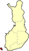 |
|||
| FI2 | Åland | Åland | ||||
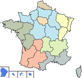
| FR |  Early Modern France Early Modern France |
|||||
| FR1 | Île-de-France Île-de-France (région) Île-de-France is the wealthiest and most populated of the twenty-two administrative regions of France, composed mostly of the Paris metropolitan area.... |
Île-de-France Île-de-France (région) Île-de-France is the wealthiest and most populated of the twenty-two administrative regions of France, composed mostly of the Paris metropolitan area.... |
 |
|||
| FR2 | Parisian basin | Champagne-Ardenne Champagne-Ardenne Champagne-Ardenne is one of the 27 regions of France. It is located in the northeast of the country, bordering Belgium, and consists of four departments: Aube, Ardennes, Haute-Marne, and Marne. The region is famous for its sparkling white wine . Its rivers, most of which flow west, include the... , Picardie Picardie Picardy is one of the 27 regions of France. It is located in the northern part of France.-History:The historical province of Picardy stretched from north of Noyon to Calais, via the whole of the Somme department and the north of the Aisne department... , Haute-Normandie Haute-Normandie Upper Normandy is one of the 27 regions of France. It was created in 1984 from two départements: Seine-Maritime and Eure, when Normandy was divided into Lower Normandy and Upper Normandy. This division continues to provoke controversy, and some continue to call for reuniting the two regions... , Centre Centre (France) Centre is one of the 27 regions of France, located towards the northwest of the actual centre of the country, around the Loire Valley. Its capital is Orléans, although its largest city is Tours.-Features:... , Basse-Normandie Basse-Normandie Lower Normandy is an administrative region of France. It was created in 1956, when the Normandy region was divided into Lower Normandy and Upper Normandy... , Bourgogne Bourgogne Burgundy is one of the 27 regions of France.The name comes from the Burgundians, an ancient Germanic people who settled in the area in early Middle-age. The region of Burgundy is both larger than the old Duchy of Burgundy and smaller than the area ruled by the Dukes of Burgundy, from the modern... |
||||
| FR3 | Nord-Pas-de-Calais | Nord-Pas-de-Calais | ||||
| FR4 | East | Lorraine Lorraine (région) Lorraine is one of the 27 régions of France. The administrative region has two cities of equal importance, Metz and Nancy. Metz is considered to be the official capital since that is where the regional parliament is situated... , Alsace Alsace Alsace is the fifth-smallest of the 27 regions of France in land area , and the smallest in metropolitan France. It is also the seventh-most densely populated region in France and third most densely populated region in metropolitan France, with ca. 220 inhabitants per km²... , Franche-Comté Franche-Comté Franche-Comté the former "Free County" of Burgundy, as distinct from the neighbouring Duchy, is an administrative region and a traditional province of eastern France... |
||||
| FR5 | West | Pays de la Loire Pays de la Loire Pays de la Loire is one of the 27 regions of France. It is one of the regions created in the late 20th century to serve as a zone of influence for its capital, Nantes, one of a handful so-called "balancing metropolises" ¹... , Brittany, Poitou-Charentes Poitou-Charentes Poitou-Charentes is an administrative region in central western France comprising four departments: Charente, Charente-Maritime, Deux-Sèvres and Vienne. The regional capital is Poitiers.-Politics:The regional council is composed of 56 members... |
||||
| FR6 | South West | Aquitaine Aquitaine Aquitaine , archaic Guyenne/Guienne , is one of the 27 regions of France, in the south-western part of metropolitan France, along the Atlantic Ocean and the Pyrenees mountain range on the border with Spain. It comprises the 5 departments of Dordogne, :Lot et Garonne, :Pyrénées-Atlantiques, Landes... , Midi-Pyrénées Midi-Pyrénées Midi-Pyrénées is the largest region of metropolitan France by area, larger than the Netherlands or Denmark.Midi-Pyrénées has no historical or geographical unity... , Limousin Limousin (région) Limousin is one of the 27 regions of France. It is composed of three départements: Corrèze, Creuse and the Haute-Vienne.Situated largely in the Massif Central, as of January 1st 2008, the Limousin comprised 740,743 inhabitants on nearly 17 000 km2, making it the second least populated region of... |
||||
| FR7 | Centre East | Rhône-Alpes Rhône-Alpes Rhône-Alpes is one of the 27 regions of France, located on the eastern border of the country, towards the south. The region was named after the Rhône River and the Alps mountain range. Its capital, Lyon, is the second-largest metropolitan area in France after Paris... , Auvergne Auvergne (région) Auvergne is one of the 27 administrative regions of France. It comprises the 4 departments of Allier, Puy de Dome, Cantal and Haute Loire.The current administrative region of Auvergne is larger than the historical province of Auvergne, and includes provinces and areas that historically were not... |
||||
| FR8 | Mediterranean | Languedoc-Roussillon Languedoc-Roussillon Languedoc-Roussillon is one of the 27 regions of France. It comprises five departments, and borders the other French regions of Provence-Alpes-Côte d'Azur, Rhône-Alpes, Auvergne, Midi-Pyrénées on the one side, and Spain, Andorra and the Mediterranean sea on the other side.-Geography:The region is... , Provence-Alpes-Côte d'Azur Provence-Alpes-Côte d'Azur Provence-Alpes-Côte d'Azur or PACA is one of the 27 regions of France.It is made up of:* the former French province of Provence* the former papal territory of Avignon, known as Comtat Venaissin... , Corse Corse Corse may refer to:*Corse, the French name for Corsica, the fourth largest island in the Mediterranean Sea*Corse , a European surname of multiple origins *Corse, a Shakespearean word for Corpse... |
||||
| FR9 | Overseas departments | Guadeloupe Guadeloupe Guadeloupe is an archipelago located in the Leeward Islands, in the Lesser Antilles, with a land area of 1,628 square kilometres and a population of 400,000. It is the first overseas region of France, consisting of a single overseas department. As with the other overseas departments, Guadeloupe... , Martinique Martinique Martinique is an island in the eastern Caribbean Sea, with a land area of . Like Guadeloupe, it is an overseas region of France, consisting of a single overseas department. To the northwest lies Dominica, to the south St Lucia, and to the southeast Barbados... , French Guiana French Guiana French Guiana is an overseas region of France, consisting of a single overseas department located on the northern Atlantic coast of South America. It has borders with two nations, Brazil to the east and south, and Suriname to the west... , Réunion Réunion Réunion is a French island with a population of about 800,000 located in the Indian Ocean, east of Madagascar, about south west of Mauritius, the nearest island.Administratively, Réunion is one of the overseas departments of France... |
||||
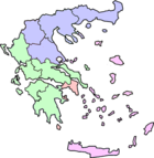
| GR NUTS of Greece In the NUTS codes of Greece , the three levels are:-NUTS codes:* GR1 VOREIA ELLADA** GR11 Anatoliki Makedonia, Thraki*** GR111 Evros Prefecture*** GR112 Xanthi Prefecture... |  Greece Greece |
|||||
| GR1 | Voreia Ellada Voreia Ellada Voreia Ellada , meaning Northern Greece, is a first level NUTS administrative division of Greece created for statistical purposes by the European Union.... |
East Macedonia and Thrace East Macedonia and Thrace East Macedonia and Thrace is one of the thirteen regions of Greece. It consists of the northeastern parts of the country, comprising the eastern part of the region of Macedonia along with the region of Thrace, and the islands of Thasos and Samothrace.... , Central Macedonia Central Macedonia Central Macedonia is one of the thirteen regions of Greece, consisting of the central part of the region of Macedonia. With a population of over 1.8 million, it is the second most populous in Greece after Attica.- Administration :... , West Macedonia West Macedonia West Macedonia is one of the thirteen regions of Greece, consisting of the western part of Greek Macedonia. It is divided into the regional units of Florina, Grevena, Kastoria, and Kozani.-Geography:... , Thessaly Thessaly Thessaly is a traditional geographical region and an administrative region of Greece, comprising most of the ancient region of the same name. Before the Greek Dark Ages, Thessaly was known as Aeolia, and appears thus in Homer's Odyssey.... |
 |
|||
| GR2 | Kentriki Ellada Kentriki Ellada Kentriki Ellada , meaning Central Greece, is a NUTS administrative division of Greece created for statistical purposes by the European Union. This first level NUTS division is not used by Greece for administrative reasons. Central Greece however is the name of both a geographical region and a... |
Epirus Epirus (periphery) Epirus , formally the Epirus Region , is a geographical and administrative region in northwestern Greece. It borders the regions of West Macedonia and Thessaly to the east, West Greece to the south, the Ionian Sea and the Ionian Islands to the west and the country of Albania to the north. The... , Ionian Islands Ionian Islands The Ionian Islands are a group of islands in Greece. They are traditionally called the Heptanese, i.e... , West Greece West Greece West Greece is one of the thirteen regions of Greece. It comprises the western part of continental Greece and the northwestern part of the Peloponnese peninsula.- Administration :... , Central Greece Central Greece Continental Greece or Central Greece , colloquially known as Roúmeli , is a geographical region of Greece. Its territory is divided into the administrative regions of Central Greece, Attica, and part of West Greece... , Peloponnese Peloponnese The Peloponnese, Peloponnesos or Peloponnesus , is a large peninsula , located in a region of southern Greece, forming the part of the country south of the Gulf of Corinth... |
||||
| GR3 | Attica Attica Attica is a historical region of Greece, containing Athens, the current capital of Greece. The historical region is centered on the Attic peninsula, which projects into the Aegean Sea... |
Attica Attica Attica is a historical region of Greece, containing Athens, the current capital of Greece. The historical region is centered on the Attic peninsula, which projects into the Aegean Sea... |
||||
| GR4 | Nisia Aigaiou, Kriti | South Aegean South Aegean The South Aegean is one of the thirteen regions of Greece. It consists of the Cyclades and Dodecanese island groups in the central and southeastern Aegean Sea.- Administration :... , North Aegean North Aegean The North Aegean is one of the thirteen regions of Greece. It comprises the islands of the north-eastern Aegean Sea, except for Samothrace, which belongs to the region of East Macedonia and Thrace, and Imbros and Tenedos which belong to Turkey.... , Crete Crete Crete is the largest and most populous of the Greek islands, the fifth largest island in the Mediterranean Sea, and one of the thirteen administrative regions of Greece. It forms a significant part of the economy and cultural heritage of Greece while retaining its own local cultural traits... |
||||
| HU |  Hungary Hungary |
|||||
| HU1 | Central Hungary Central Hungary Central Hungary is one of the seven statistical regions in Hungary . It includes and .- Administration :... |
Central Hungary Central Hungary Central Hungary is one of the seven statistical regions in Hungary . It includes and .- Administration :... |
 |
|||
| HU2 | Transdanubia Transdanubia Transdanubia is a traditional region of Hungary.-Traditional interpretation:The borders of Transdanubia are the Danube river , the Drava and Mura rivers and the foothills of the Alps roughly along the border between Hungary and Austria .Transdanubia comprises the counties of Győr-Moson-Sopron,... |
Central Transdanubia Central Transdanubia Central Transdanubia is a statistical region of Hungary. It is part of Transdanubia region. Central Transdanubia includes counties of Fejér, Komárom-Esztergom, and Veszprém.... , Western Transdanubia Western Transdanubia Western Transdanubia is a statistical region of Hungary. It is part of the Transdanubia region. Western Transdanubia includes the counties of Zala, Vas, and Győr-Moson-Sopron.... , Southern Transdanubia Southern Transdanubia Southern Transdanubia is a statistical region of Hungary. It is part of the Transdanubia region. Southern Transdanubia includes the counties of Somogy, Tolna, and Baranya. Its capital is the city of Pécs.... |
||||
| HU3 | Great Plain and North | Northern Hungary Northern Hungary Northern Hungary is a region in Hungary. As a statistical region it includes the counties Borsod-Abaúj-Zemplén, Heves and Nógrád, but in colloquial speech it usually also refers to Szabolcs-Szatmár-Bereg county. The region is actually in the north-eastern part of the country, but the northwestern... , Northern Great Plain Northern Great Plain Northern Great Plain is a statistical region of Hungary. It is part of Great Plain and North region. Northern Great Plain includes the counties of Hajdú-Bihar, Jász-Nagykun-Szolnok, and Szabolcs-Szatmár-Bereg. It is also one of the largest plains in the world with an area of about 3000 square... , Southern Great Plain Southern Great Plain Southern Great Plain is a statistical region of Hungary. It is part of Great Plain and North region. Southern Great Plain includes the 3 counties:* Bács-Kiskun* Békés* Csongrád... |
||||
| IE |  Republic of Ireland Republic of Ireland |
|||||
| IE0 | Ireland Ireland Ireland is an island to the northwest of continental Europe. It is the third-largest island in Europe and the twentieth-largest island on Earth... |
Border, Midland and Western, Southern and Eastern |  |
|||
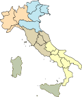
| IT |  Italy Italy |
|||||
| ITC | North West Northwest Italy Northwest Italy is one of the five official statistical regions of Italy used by the National Institute of Statistics , a first level NUTS region and a European Parliament constituency... |
Aosta Valley, Liguria Liguria Liguria is a coastal region of north-western Italy, the third smallest of the Italian regions. Its capital is Genoa. It is a popular region with tourists for its beautiful beaches, picturesque little towns, and good food.-Geography:... , Lombardy Lombardy Lombardy is one of the 20 regions of Italy. The capital is Milan. One-sixth of Italy's population lives in Lombardy and about one fifth of Italy's GDP is produced in this region, making it the most populous and richest region in the country and one of the richest in the whole of Europe... , Piedmont Piedmont Piedmont is one of the 20 regions of Italy. It has an area of 25,402 square kilometres and a population of about 4.4 million. The capital of Piedmont is Turin. The main local language is Piedmontese. Occitan is also spoken by a minority in the Occitan Valleys situated in the Provinces of... |
 |
|||
| ITD | North East Northeast Italy Northeast Italy is one of the five official statistical regions of Italy used by the National Institute of Statistics , a first level NUTS region and a European Parliament constituency... |
Emilia-Romagna Emilia-Romagna Emilia–Romagna is an administrative region of Northern Italy comprising the two historic regions of Emilia and Romagna. The capital is Bologna; it has an area of and about 4.4 million inhabitants.... , Friuli-Venezia Giulia Friuli-Venezia Giulia Friuli–Venezia Giulia is one of the twenty regions of Italy, and one of five autonomous regions with special statute. The capital is Trieste. It has an area of 7,858 km² and about 1.2 million inhabitants. A natural opening to the sea for many Central European countries, the region is... , Trentino-Alto Adige/Südtirol, Veneto Veneto Veneto is one of the 20 regions of Italy. Its population is about 5 million, ranking 5th in Italy.Veneto had been for more than a millennium an independent state, the Republic of Venice, until it was eventually annexed by Italy in 1866 after brief Austrian and French rule... |
||||
| ITE | Centre Central Italy Central Italy is one of the five official statistical regions of Italy used by the National Institute of Statistics , a first level NUTS region and a European Parliament constituency... |
Lazio, Marche Marche The population density in the region is below the national average. In 2008, it was 161.5 inhabitants per km2, compared to the national figure of 198.8. It is highest in the province of Ancona , and lowest in the province of Macerata... , Tuscany Tuscany Tuscany is a region in Italy. It has an area of about 23,000 square kilometres and a population of about 3.75 million inhabitants. The regional capital is Florence .... , Umbria Umbria Umbria is a region of modern central Italy. It is one of the smallest Italian regions and the only peninsular region that is landlocked.Its capital is Perugia.Assisi and Norcia are historical towns associated with St. Francis of Assisi, and St... |
||||
| ITF | South South Italy South Italy is one of the five official statistical regions of Italy used by the National Institute of Statistics , a first level NUTS region and a European Parliament constituency. South Italy encompasses six of the country's 20 regions:*Abruzzo... |
Abruzzo Abruzzo Abruzzo is a region in Italy, its western border lying less than due east of Rome. Abruzzo borders the region of Marche to the north, Lazio to the west and south-west, Molise to the south-east, and the Adriatic Sea to the east... , Apulia Apulia Apulia is a region in Southern Italy bordering the Adriatic Sea in the east, the Ionian Sea to the southeast, and the Strait of Òtranto and Gulf of Taranto in the south. Its most southern portion, known as Salento peninsula, forms a high heel on the "boot" of Italy. The region comprises , and... , Basilicata Basilicata Basilicata , also known as Lucania, is a region in the south of Italy, bordering on Campania to the west, Apulia to the north and east, and Calabria to the south, having one short southwestern coastline on the Tyrrhenian Sea between Campania in the northwest and Calabria in the southwest, and a... , Calabria Calabria Calabria , in antiquity known as Bruttium, is a region in southern Italy, south of Naples, located at the "toe" of the Italian Peninsula. The capital city of Calabria is Catanzaro.... , Campania Campania Campania is a region in southern Italy. The region has a population of around 5.8 million people, making it the second-most-populous region of Italy; its total area of 13,590 km² makes it the most densely populated region in the country... , Molise Molise Molise is a region of Southern Italy, the second smallest of the regions. It was formerly part of the region of Abruzzi e Molise and now a separate entity... |
||||
| ITG | Islands Insular Italy Insular Italy is one of the five official statistical regions of Italy used by the National Institute of Statistics , a first level NUTS region and a European Parliament constituency. Insular Italy encompasses two of the country's 20 regions:... |
Sardinia Sardinia Sardinia is the second-largest island in the Mediterranean Sea . It is an autonomous region of Italy, and the nearest land masses are the French island of Corsica, the Italian Peninsula, Sicily, Tunisia and the Spanish Balearic Islands.The name Sardinia is from the pre-Roman noun *sard[],... , Sicily Sicily Sicily is a region of Italy, and is the largest island in the Mediterranean Sea. Along with the surrounding minor islands, it constitutes an autonomous region of Italy, the Regione Autonoma Siciliana Sicily has a rich and unique culture, especially with regard to the arts, music, literature,... |
||||
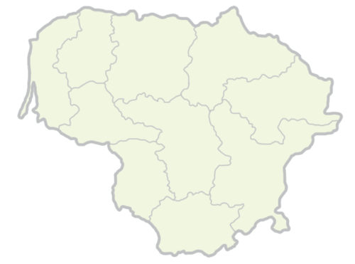
| LT NUTS of Lithuania In the NUTS codes of Lithuania , the three levels are:-NUTS codes:* Subdivisions of Lithuania* ISO 3166-2 codes of Lithuania* FIPS region codes of Lithuania-Sources:* * ** ** * * **... |  Lithuania Lithuania |
|||||
| LT0 | Lithuania Lithuania Lithuania , officially the Republic of Lithuania is a country in Northern Europe, the biggest of the three Baltic states. It is situated along the southeastern shore of the Baltic Sea, whereby to the west lie Sweden and Denmark... |
Lithuania Lithuania Lithuania , officially the Republic of Lithuania is a country in Northern Europe, the biggest of the three Baltic states. It is situated along the southeastern shore of the Baltic Sea, whereby to the west lie Sweden and Denmark... |
 |
|||
| LU NUTS of Luxembourg In the NUTS codes of Luxembourg , the three levels are:-Local administrative units:Below the NUTS levels, the two LAU levels are:... |  Luxembourg Luxembourg |
|||||
| LU0 | Luxembourg Luxembourg Luxembourg , officially the Grand Duchy of Luxembourg , is a landlocked country in western Europe, bordered by Belgium, France, and Germany. It has two principal regions: the Oesling in the North as part of the Ardennes massif, and the Gutland in the south... |
Luxembourg Luxembourg Luxembourg , officially the Grand Duchy of Luxembourg , is a landlocked country in western Europe, bordered by Belgium, France, and Germany. It has two principal regions: the Oesling in the North as part of the Ardennes massif, and the Gutland in the south... |
 |
|||
| LV NUTS of Latvia In the NUTS codes of Latvia , the three levels are:-NUTS codes:The LAU codes of Latvia can be downloaded here: -See also:* Subdivisions of Latvia* ISO 3166-2 codes of Latvia... |  Latvia Latvia |
|||||
| LV0 | Latvia Latvia Latvia , officially the Republic of Latvia , is a country in the Baltic region of Northern Europe. It is bordered to the north by Estonia , to the south by Lithuania , to the east by the Russian Federation , to the southeast by Belarus and shares maritime borders to the west with Sweden... |
Latvia Latvia Latvia , officially the Republic of Latvia , is a country in the Baltic region of Northern Europe. It is bordered to the north by Estonia , to the south by Lithuania , to the east by the Russian Federation , to the southeast by Belarus and shares maritime borders to the west with Sweden... |
||||
| MT NUTS of Malta In the NUTS codes of Malta , the three levels are:-NUTS codes:Below the NUTS levels, the two LAU levels are:The LAU codes of Malta can be downloaded here: ... |  Malta Malta |
|||||
| MT0 | Malta Malta Malta , officially known as the Republic of Malta , is a Southern European country consisting of an archipelago situated in the centre of the Mediterranean, south of Sicily, east of Tunisia and north of Libya, with Gibraltar to the west and Alexandria to the east.Malta covers just over in... |
Malta Malta Malta , officially known as the Republic of Malta , is a Southern European country consisting of an archipelago situated in the centre of the Mediterranean, south of Sicily, east of Tunisia and north of Libya, with Gibraltar to the west and Alexandria to the east.Malta covers just over in... |
 |
|||
| NL |  Netherlands Netherlands |
|||||
| NL1 | North Netherlands | Groningen Groningen (province) Groningen [] is the northeasternmost province of the Netherlands. In the east it borders the German state of Niedersachsen , in the south Drenthe, in the west Friesland and in the north the Wadden Sea... , Friesland Friesland Friesland is a province in the north of the Netherlands and part of the ancient region of Frisia.Until the end of 1996, the province bore Friesland as its official name. In 1997 this Dutch name lost its official status to the Frisian Fryslân... , Drenthe Drenthe Drenthe is a province of the Netherlands, located in the north-east of the country. The capital city is Assen. It is bordered by Overijssel to the south, Friesland to the west, Groningen to the north, and Germany to the east.-History:Drenthe, unlike many other parts of the Netherlands, has been a... |
 |
|||
| NL2 | East Netherlands | Overijssel Overijssel Overijssel is a province of the Netherlands in the central eastern part of the country. The region has a NUTS classification of NL21. The province's name means "Lands across river IJssel". The capital city of Overijssel is Zwolle and the largest city is Enschede... , Gelderland Gelderland Gelderland is the largest province of the Netherlands, located in the central eastern part of the country. The capital city is Arnhem. The two other major cities, Nijmegen and Apeldoorn have more inhabitants. Other major regional centers in Gelderland are Ede, Doetinchem, Zutphen, Tiel, Wijchen,... , Flevoland Flevoland Flevoland is a province of the Netherlands. Located in the centre of the country, at the location of the former Zuiderzee, the province was established on January 1, 1986; the twelfth province of the country, with Lelystad as its capital... |
||||
| NL3 | West Netherlands | Utrecht Utrecht (province) Utrecht is the smallest province of the Netherlands in terms of area, and is located in the centre of the country. It is bordered by the Eemmeer in the north, Gelderland in the east, the river Rhine in the south, South Holland in the west, and North Holland in the northwest... , North Holland North Holland North Holland |West Frisian]]: Noard-Holland) is a province situated on the North Sea in the northwest part of the Netherlands. The provincial capital is Haarlem and its largest city is Amsterdam.-Geography:... , South Holland South Holland South Holland is a province situated on the North Sea in the western part of the Netherlands. The provincial capital is The Hague and its largest city is Rotterdam.South Holland is one of the most densely populated and industrialised areas in the world... , Zeeland Zeeland Zeeland , also called Zealand in English, is the westernmost province of the Netherlands. The province, located in the south-west of the country, consists of a number of islands and a strip bordering Belgium. Its capital is Middelburg. With a population of about 380,000, its area is about... |
||||
| NL4 | South Netherlands | North Brabant North Brabant North Brabant , sometimes called Brabant, is a province of the Netherlands, located in the south of the country, bordered by Belgium in the south, the Meuse River in the north, Limburg in the east and Zeeland in the west.- History :... , Limburg Limburg (Netherlands) Limburg is the southernmost of the twelve provinces of the Netherlands. It is located in the southeastern part of the country and bordered by the province of Gelderland to the north, Germany to the east, Belgium to the south and part of the west, andthe Dutch province of North Brabant partly to... |
||||
| PL NUTS of Poland In the NUTS codes of Poland , the three levels are:-NUTS codes:In the NUTS codes of Poland , the three levels are:... |  Poland Poland |
|||||
| PL1 | Centralny | Łódź, Mazovia Masovian Voivodeship -Administrative division:Masovian Voivodeship is divided into 42 counties : 5 city counties and 37 "land counties"... |
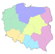 |
|||
| PL2 | Poludniowy | Lesser Poland Lesser Poland Voivodeship Małopolska Voivodeship , or Lesser Poland Voivodeship, is a voivodeship, in southern Poland... , Silesia Silesian Voivodeship Silesian Voivodeship, or Silesia Province , is a voivodeship, or province, in southern Poland, centering on the historic region known as Upper Silesia... |
||||
| PL3 | Wschodni | Lublin Lublin Voivodeship - Administrative division :Lublin Voivodeship is divided into 24 counties : 4 city counties and 20 land counties. These are further divided into 213 gminas.... , Subcarpathian Subcarpathian Voivodeship Podkarpackie Voivodeship , or Subcarpathian Voivodeship, is a voivodeship, or province, in extreme-southeastern Poland. Its administrative capital and largest city is Rzeszów... , Świętokrzyskie Swietokrzyskie Voivodeship Świętokrzyskie Voivodeship, or Świętokrzyskie Province , is one of the 16 voivodeships into which Poland is presently divided. It is situated in central Poland, in the historical province of Lesser Poland, and takes its name from the Świętokrzyskie mountain range... , Podlaskie Podlaskie Voivodeship Podlaskie Voivodeship , is a voivodeship in northeastern Poland. It borders on Masovian Voivodeship to the west, Warmian-Masurian Voivodeship to the northwest, Lublin Voivodeship to the south, the Belarusssian Voblasts of Grodno and Brest to the east, the Lithuanian Counties of Alytus and... |
||||
| PL4 | Północno-Zachodni | Greater Poland Greater Poland Voivodeship Wielkopolska Voivodeship , or Greater Poland Voivodeship, is a voivodeship, or province, in west-central Poland. It was created on 1 January 1999 out of the former Poznań, Kalisz, Konin, Piła and Leszno Voivodeships, pursuant to the Polish local government reforms adopted in 1998... , West Pomerania West Pomeranian Voivodeship West Pomeranian Voivodeship, , is a voivodeship in northwestern Poland. It borders on Pomeranian Voivodeship to the east, Greater Poland Voivodeship to the southeast, Lubusz Voivodeship to the south, the German federal-state of Mecklenburg-West Pomerania to the west, and the Baltic Sea to the north... , Lubusz Lubusz Voivodeship - Administrative division :Lubusz Voivodeship is divided into 14 counties : 2 city counties and 12 land counties. These are further divided into 83 gminas.... |
||||
| PL5 | Południowo-Zachodni | Lower Silesia Lower Silesian Voivodeship Lower Silesian Voivodeship, or Lower Silesia Province , is one of the 16 voivodeships into which Poland is currently divided. It lies in southwestern Poland... , Opole Voivodeship Opole Voivodeship - Administrative division :Opole Voivodeship is divided into 12 counties : 1 city county and 11 land counties. These are further divided into 71 gminas.The counties are listed in the following table .- Economy :... |
||||
| PL6 | Północny | Kuyavian-Pomeranian Kuyavian-Pomeranian Voivodeship -Transportation:Transportation infrastructure is of critical importance to the voivodeship's economy. Kuyavia-Pomerania is a major node point in the Polish transportation system. Railway lines from the South and East pass through Bydgoszcz in order to reach the major ports on the Baltic Sea... , Varmia-Masuria Warmian-Masurian Voivodeship Warmian-Masurian Voivodeship, or Warmia-Masuria Province , is a voivodeship in northeastern Poland. Its capital and largest city is Olsztyn... , Pomerania Pomeranian Voivodeship Pomeranian Voivodeship, or Pomerania Province , is a voivodeship, or province, in north-central Poland. It comprises most of Pomerelia , as well as an area east of the Vistula River... |
||||
| PT NUTS of Portugal In the NUTS codes of Portugal , the three levels are:-NUTS codes:In the NUTS codes of Portugal , the three levels are:... |  Portugal Portugal |
|||||
| PT1 | Mainland Portugal | Norte, Algarve, Centro, Lisbon, Alentejo | 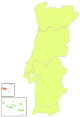 |
|||
| PT2 | Azores Azores The Archipelago of the Azores is composed of nine volcanic islands situated in the middle of the North Atlantic Ocean, and is located about west from Lisbon and about east from the east coast of North America. The islands, and their economic exclusion zone, form the Autonomous Region of the... |
Azores Azores The Archipelago of the Azores is composed of nine volcanic islands situated in the middle of the North Atlantic Ocean, and is located about west from Lisbon and about east from the east coast of North America. The islands, and their economic exclusion zone, form the Autonomous Region of the... |
||||
| PT3 | Madeira Madeira Madeira is a Portuguese archipelago that lies between and , just under 400 km north of Tenerife, Canary Islands, in the north Atlantic Ocean and an outermost region of the European Union... |
Madeira Madeira Madeira is a Portuguese archipelago that lies between and , just under 400 km north of Tenerife, Canary Islands, in the north Atlantic Ocean and an outermost region of the European Union... |
||||
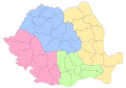
| RO NUTS of Romania In the NUTS codes of Romania , the three levels are:-NUTS codes:In the NUTS codes of Romania , the three levels are:... |  Kingdom of Romania Kingdom of Romania |
|||||
| RO1 | One | Nord-Vest Nord-Vest (development region) Nord-Vest is a development region in Romania, created in 1998. As other development regions, it does not have any administrative powers, its main function being to co-ordinate regional development projects and manage funds from the European Union.-Counties:The Nord-Vest region is made up of the... , Centru Centru (development region) Centru is a development region in Romania.-Demographics:Centru has a total population of 2,523,021. Its population density is 73.99/km², somewhat lower than the national average of 91.3/km². The region is one of the most ethnically-diverse in Romania, with ethnic Romanians making up 65.4% of the... |
 |
|||
| RO2 | Two | Nord-Est Nord-Est (development region) Nord-Est or Nord-Est Moldova is a development region in Romania.-Counties:The Nord-Est region is made up of the following counties:*Bacău*Botoşani*Iaşi*Neamţ*Suceava*Vaslui-Economy:... , Sud-Est Sud-Est (development region) Sud-Est is a development region in Romania.- References :... |
||||
| RO3 | Three | Sud Sud (development region) Sud or Sud-Muntenia is a development region in Romania. The Capital of South Development Region is Călăraşi.- References :... , Bucureşti-Ilfov Bucharest-Ilfov (development region) The Bucharest-Ilfov development region is a development region in Romania, encompassing the national capital, Bucharest, as well as the surrounding Ilfov County. As other development regions, it does not have any administrative powers, its main function being to co-ordinate regional development... |
||||
| RO4 | Four | Sud-Vest Sud-Vest (development region) Sud-Vest or Sud-Vest Oltenia is a development region in Romania. It is roughly coterminous with the historic region of Oltenia , and from that reason it is called sometimes Regiunea de dezvoltare Sud-Vest Oltenia.Danube forms boundary between Romania and Serbia/Bulgaria.- References :*... , Vest Vest (development region) Vest or Vest-Banat is a development region in Romania created in 1998. As with the other development regions, it does not have any administrative powers. Its primary functions are coordinating regional development projects and managing funds from the European Union.- References :... |
||||
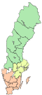
| SE |  Sweden Sweden |
|||||
| SE1 | East Sweden | Stockholm County Stockholm County Stockholm County is a county or län on the Baltic sea coast of Sweden. It borders Uppsala County and Södermanland County. It also borders Mälaren and the Baltic Sea. The city of Stockholm is the capital of Sweden. Stockholm County is divided by the historic provinces of Uppland and Södermanland... , East Middle Sweden East Middle Sweden East Middle Sweden is a National Area of Sweden. The National Areas are a part of the Nomenclature of Territorial Units for Statistics of Sweden.-Geography:... |
 |
|||
| SE2 | South Sweden South Sweden South Sweden is a National Area of Sweden. The National Areas are a part of the Nomenclature of Territorial Units for Statistics of Sweden.-Geography:South Sweden is situated in the southern part of its country... |
Småland and the islands Småland and the islands Småland and the islands is a National Area of Sweden. The National Areas are a part of the Nomenclature of Territorial Units for Statistics of Sweden... , South Sweden South Sweden South Sweden is a National Area of Sweden. The National Areas are a part of the Nomenclature of Territorial Units for Statistics of Sweden.-Geography:South Sweden is situated in the southern part of its country... , West Sweden |
||||
| SE3 | North Sweden | North Middle Sweden North Middle Sweden North Middle Sweden is a National Area of Sweden. The National Areas are a part of the Nomenclature of Territorial Units for Statistics of Sweden.-Geography:... , Middle Norrland Middle Norrland Middle Norrland is a National Area of Sweden. The National Areas are a part of the Nomenclature of Territorial Units for Statistics of Sweden.-Geography:... , Upper Norrland Upper Norrland Upper Norrland is a National Area of Sweden. The National Areas are a part of the Nomenclature of Territorial Units for Statistics of Sweden.-Geography:... |
||||
| SI NUTS of Slovenia In the NUTS codes of Slovenia , the three levels are:-NUTS codes:... |  Slovenia Slovenia |
|||||
| SI0 | Slovenia Slovenia Slovenia , officially the Republic of Slovenia , is a country in Central and Southeastern Europe touching the Alps and bordering the Mediterranean. Slovenia borders Italy to the west, Croatia to the south and east, Hungary to the northeast, and Austria to the north, and also has a small portion of... |
Eastern Slovenia Eastern Slovenia Eastern Slovenia is one of the two NUTS-2 Regions of Slovenia. The region forms the eastern part of the country and includes the cities of Maribor, Celje and Velenje. It is the poorer of the two regions of Slovenia and its GDP per capita is 72.5% of the European Union average .... , Western Slovenia Western Slovenia Western Slovenia is one of the two NUTS-2 Regions of Slovenia. The region forms the western part of the country and includes the cities of Ljubljana, Koper, Kranj and Nova Gorica. It is the richer of the two regions of Slovenia and its GDP per capita is 105.4% of the European Union average .... |
 |
|||
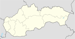
| SK NUTS of Slovakia In the NUTS codes of Slovakia , the three levels are:-NUTS codes:* ISO 3166-2 codes of Slovakia* FIPS region codes of Slovakia-Sources:* * ** ** * * ** * , Statoids.com... |  Slovakia Slovakia |
|||||
| SK0 | Slovakia Slovakia The Slovak Republic is a landlocked state in Central Europe. It has a population of over five million and an area of about . Slovakia is bordered by the Czech Republic and Austria to the west, Poland to the north, Ukraine to the east and Hungary to the south... |
Bratislava Region Bratislava Region The Bratislava Region is one of the administrative regions of Slovakia. Its capital is Bratislava. It is the smallest of the eight regions of Slovakia.-Geography:... , Western Slovakia, Central Slovakia, Eastern Slovakia |
 |
|||
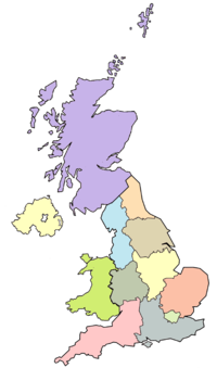
| UK |  United Kingdom United Kingdom |
|||||
| UKC | North East England North East England North East England is one of the nine official regions of England. It covers Northumberland, County Durham, Tyne and Wear, and Teesside . The only cities in the region are Durham, Newcastle upon Tyne and Sunderland... |
Tees Valley Tees Valley The Tees Valley is an area in the North East of England. It can be described as "greater Teesside" and consists of the four unitary authorities created by the breakup of the County of Cleveland in 1996: Hartlepool, Middlesbrough, Redcar & Cleveland, and Stockton-On-Tees along with the borough of... and Durham Durham Durham is a city in north east England. It is within the County Durham local government district, and is the county town of the larger ceremonial county... , Northumberland Northumberland Northumberland is the northernmost ceremonial county and a unitary district in North East England. For Eurostat purposes Northumberland is a NUTS 3 region and is one of three boroughs or unitary districts that comprise the "Northumberland and Tyne and Wear" NUTS 2 region... and Tyne and Wear Tyne and Wear Tyne and Wear is a metropolitan county in north east England around the mouths of the Rivers Tyne and Wear. It came into existence as a metropolitan county in 1974 after the passage of the Local Government Act 1972... |
 |
|||
| UKD | North West England North West England North West England, informally known as The North West, is one of the nine official regions of England.North West England had a 2006 estimated population of 6,853,201 the third most populated region after London and the South East... |
Cumbria Cumbria Cumbria , is a non-metropolitan county in North West England. The county and Cumbria County Council, its local authority, came into existence in 1974 after the passage of the Local Government Act 1972. Cumbria's largest settlement and county town is Carlisle. It consists of six districts, and in... , Cheshire Cheshire Cheshire is a ceremonial county in North West England. Cheshire's county town is the city of Chester, although its largest town is Warrington. Other major towns include Widnes, Congleton, Crewe, Ellesmere Port, Runcorn, Macclesfield, Winsford, Northwich, and Wilmslow... , Greater Manchester Greater Manchester Greater Manchester is a metropolitan county in North West England, with a population of 2.6 million. It encompasses one of the largest metropolitan areas in the United Kingdom and comprises ten metropolitan boroughs: Bolton, Bury, Oldham, Rochdale, Stockport, Tameside, Trafford, Wigan, and the... , Lancashire Lancashire Lancashire is a non-metropolitan county of historic origin in the North West of England. It takes its name from the city of Lancaster, and is sometimes known as the County of Lancaster. Although Lancaster is still considered to be the county town, Lancashire County Council is based in Preston... , Merseyside Merseyside Merseyside is a metropolitan county in North West England, with a population of 1,365,900. It encompasses the metropolitan area centred on both banks of the lower reaches of the Mersey Estuary, and comprises five metropolitan boroughs: Knowsley, St Helens, Sefton, Wirral, and the city of Liverpool... |
||||
| UKE | Yorkshire and the Humber Yorkshire and the Humber Yorkshire and the Humber is one of the nine regions of England and formally one of the government office regions. It covers most of the historic county of Yorkshire, along with the part of northern Lincolnshire that was, from 1974 to 1996, within the former shire county of Humberside. The... |
East Yorkshire East Yorkshire East Yorkshire could be:*East Yorkshire Motor Services*An alternative name for the East Riding of Yorkshire*East Yorkshire , a former district of Humberside*East Yorkshire... and Northern Lincolnshire (Humberside Humberside Humberside was a non-metropolitan and ceremonial county in Northern England from 1 April 1974 until 1 April 1996. It was composed of land from either side of the Humber Estuary, created from portions of the East and West ridings of Yorkshire and parts of Lindsey, Lincolnshire... ), North Yorkshire North Yorkshire North Yorkshire is a non-metropolitan or shire county located in the Yorkshire and the Humber region of England, and a ceremonial county primarily in that region but partly in North East England. Created in 1974 by the Local Government Act 1972 it covers an area of , making it the largest... , South Yorkshire South Yorkshire South Yorkshire is a metropolitan county in the Yorkshire and the Humber region of England. It has a population of 1.29 million. It consists of four metropolitan boroughs: Barnsley, Doncaster, Rotherham, and City of Sheffield... , West Yorkshire West Yorkshire West Yorkshire is a metropolitan county within the Yorkshire and the Humber region of England with a population of 2.2 million. West Yorkshire came into existence as a metropolitan county in 1974 after the passage of the Local Government Act 1972.... |
||||
| UKF | East Midlands East Midlands The East Midlands is one of the regions of England, consisting of most of the eastern half of the traditional region of the Midlands. It encompasses the combined area of Nottinghamshire, Derbyshire, Leicestershire, Rutland, Northamptonshire and most of Lincolnshire... |
Derbyshire Derbyshire Derbyshire is a county in the East Midlands of England. A substantial portion of the Peak District National Park lies within Derbyshire. The northern part of Derbyshire overlaps with the Pennines, a famous chain of hills and mountains. The county contains within its boundary of approx... and Nottinghamshire Nottinghamshire Nottinghamshire is a county in the East Midlands of England, bordering South Yorkshire to the north-west, Lincolnshire to the east, Leicestershire to the south, and Derbyshire to the west... , Leicestershire Leicestershire Leicestershire is a landlocked county in the English Midlands. It takes its name from the heavily populated City of Leicester, traditionally its administrative centre, although the City of Leicester unitary authority is today administered separately from the rest of Leicestershire... , Rutland Rutland Rutland is a landlocked county in central England, bounded on the west and north by Leicestershire, northeast by Lincolnshire and southeast by Peterborough and Northamptonshire.... and Northamptonshire Northamptonshire Northamptonshire is a landlocked county in the English East Midlands, with a population of 629,676 as at the 2001 census. It has boundaries with the ceremonial counties of Warwickshire to the west, Leicestershire and Rutland to the north, Cambridgeshire to the east, Bedfordshire to the south-east,... , Lincolnshire Lincolnshire Lincolnshire is a county in the east of England. It borders Norfolk to the south east, Cambridgeshire to the south, Rutland to the south west, Leicestershire and Nottinghamshire to the west, South Yorkshire to the north west, and the East Riding of Yorkshire to the north. It also borders... |
||||
| UKG | West Midlands West Midlands (region) The West Midlands is an official region of England, covering the western half of the area traditionally known as the Midlands. It contains the second most populous British city, Birmingham, and the larger West Midlands conurbation, which includes the city of Wolverhampton and large towns of Dudley,... |
Herefordshire Herefordshire Herefordshire is a historic and ceremonial county in the West Midlands region of England. For Eurostat purposes it is a NUTS 3 region and is one of three counties that comprise the "Herefordshire, Worcestershire and Gloucestershire" NUTS 2 region. It also forms a unitary district known as the... , Worcestershire Worcestershire Worcestershire is a non-metropolitan county, established in antiquity, located in the West Midlands region of England. For Eurostat purposes it is a NUTS 3 region and is one of three counties that comprise the "Herefordshire, Worcestershire and Warwickshire" NUTS 2 region... and Warwickshire Warwickshire Warwickshire is a landlocked non-metropolitan county in the West Midlands region of England. The county town is Warwick, although the largest town is Nuneaton. The county is famous for being the birthplace of William Shakespeare... , Shropshire Shropshire Shropshire is a county in the West Midlands region of England. For Eurostat purposes, the county is a NUTS 3 region and is one of four counties or unitary districts that comprise the "Shropshire and Staffordshire" NUTS 2 region. It borders Wales to the west... and Staffordshire Staffordshire Staffordshire is a landlocked county in the West Midlands region of England. For Eurostat purposes, the county is a NUTS 3 region and is one of four counties or unitary districts that comprise the "Shropshire and Staffordshire" NUTS 2 region. Part of the National Forest lies within its borders... , West Midlands West Midlands (county) The West Midlands is a metropolitan county in western central England with a 2009 estimated population of 2,638,700. It came into existence as a metropolitan county in 1974 after the passage of the Local Government Act 1972, formed from parts of Staffordshire, Worcestershire and Warwickshire. The... |
||||
| UKH | East of England East of England The East of England is one of the nine official regions of England. It was created in 1994 and was adopted for statistics from 1999. It includes the ceremonial counties of Essex, Hertfordshire, Bedfordshire, Cambridgeshire, Norfolk and Suffolk. Essex has the highest population in the region.Its... |
East Anglia East Anglia East Anglia is a traditional name for a region of eastern England, named after an ancient Anglo-Saxon kingdom, the Kingdom of the East Angles. The Angles took their name from their homeland Angeln, in northern Germany. East Anglia initially consisted of Norfolk and Suffolk, but upon the marriage of... , Bedfordshire Bedfordshire Bedfordshire is a ceremonial county of historic origin in England that forms part of the East of England region.It borders Cambridgeshire to the north-east, Northamptonshire to the north, Buckinghamshire to the west and Hertfordshire to the south-east.... and Hertfordshire Hertfordshire Hertfordshire is a ceremonial and non-metropolitan county in the East region of England. The county town is Hertford.The county is one of the Home Counties and lies inland, bordered by Greater London , Buckinghamshire , Bedfordshire , Cambridgeshire and... , Essex Essex Essex is a ceremonial and non-metropolitan county in the East region of England, and one of the home counties. It is located to the northeast of Greater London. It borders with Cambridgeshire and Suffolk to the north, Hertfordshire to the west, Kent to the South and London to the south west... |
||||
| UKI | Greater London Greater London Greater London is the top-level administrative division of England covering London. It was created in 1965 and spans the City of London, including Middle Temple and Inner Temple, and the 32 London boroughs. This territory is coterminate with the London Government Office Region and the London... |
Inner London Inner London Inner London is the name for the group of London boroughs which form the interior part of Greater London and are surrounded by Outer London. The area was first officially defined in 1965 and for purposes such as statistics, the definition has changed over time. The terms Inner London and Central... , Outer London Outer London Outer London is the name for the group of London Boroughs that form a ring around Inner London.These were areas that were not part of the County of London and became formally part of Greater London in 1965... |
||||
| UKJ | South East England South East England South East England is one of the nine official regions of England, designated in 1994 and adopted for statistical purposes in 1999. It consists of Berkshire, Buckinghamshire, East Sussex, Hampshire, Isle of Wight, Kent, Oxfordshire, Surrey and West Sussex... |
Berkshire Berkshire Berkshire is a historic county in the South of England. It is also often referred to as the Royal County of Berkshire because of the presence of the royal residence of Windsor Castle in the county; this usage, which dates to the 19th century at least, was recognised by the Queen in 1957, and... , Buckinghamshire Buckinghamshire Buckinghamshire is a ceremonial and non-metropolitan home county in South East England. The county town is Aylesbury, the largest town in the ceremonial county is Milton Keynes and largest town in the non-metropolitan county is High Wycombe.... , Oxfordshire Oxfordshire Oxfordshire is a county in the South East region of England, bordering on Warwickshire and Northamptonshire , Buckinghamshire , Berkshire , Wiltshire and Gloucestershire .... , Surrey Surrey Surrey is a county in the South East of England and is one of the Home Counties. The county borders Greater London, Kent, East Sussex, West Sussex, Hampshire and Berkshire. The historic county town is Guildford. Surrey County Council sits at Kingston upon Thames, although this has been part of... , East Sussex East Sussex East Sussex is a county in South East England. It is bordered by the counties of Kent, Surrey and West Sussex, and to the south by the English Channel.-History:... , West Sussex West Sussex West Sussex is a county in the south of England, bordering onto East Sussex , Hampshire and Surrey. The county of Sussex has been divided into East and West since the 12th century, and obtained separate county councils in 1888, but it remained a single ceremonial county until 1974 and the coming... , Hampshire Hampshire Hampshire is a county on the southern coast of England in the United Kingdom. The county town of Hampshire is Winchester, a historic cathedral city that was once the capital of England. Hampshire is notable for housing the original birthplaces of the Royal Navy, British Army, and Royal Air Force... , Isle of Wight Isle of Wight The Isle of Wight is a county and the largest island of England, located in the English Channel, on average about 2–4 miles off the south coast of the county of Hampshire, separated from the mainland by a strait called the Solent... , Kent Kent Kent is a county in southeast England, and is one of the home counties. It borders East Sussex, Surrey and Greater London and has a defined boundary with Essex in the middle of the Thames Estuary. The ceremonial county boundaries of Kent include the shire county of Kent and the unitary borough of... |
||||
| UKK | South West England South West England South West England is one of the regions of England defined by the Government of the United Kingdom for statistical and other purposes. It is the largest such region in area, covering and comprising Bristol, Gloucestershire, Somerset, Dorset, Wiltshire, Devon, Cornwall and the Isles of Scilly. ... |
Gloucestershire Gloucestershire Gloucestershire is a county in South West England. The county comprises part of the Cotswold Hills, part of the flat fertile valley of the River Severn, and the entire Forest of Dean.... , Wiltshire Wiltshire Wiltshire is a ceremonial county in South West England. It is landlocked and borders the counties of Dorset, Somerset, Hampshire, Gloucestershire, Oxfordshire and Berkshire. It contains the unitary authority of Swindon and covers... and Bristol Bristol Bristol is a city, unitary authority area and ceremonial county in South West England, with an estimated population of 433,100 for the unitary authority in 2009, and a surrounding Larger Urban Zone with an estimated 1,070,000 residents in 2007... /Bath area, Dorset Dorset Dorset , is a county in South West England on the English Channel coast. The county town is Dorchester which is situated in the south. The Hampshire towns of Bournemouth and Christchurch joined the county with the reorganisation of local government in 1974... and Somerset Somerset The ceremonial and non-metropolitan county of Somerset in South West England borders Bristol and Gloucestershire to the north, Wiltshire to the east, Dorset to the south-east, and Devon to the south-west. It is partly bounded to the north and west by the Bristol Channel and the estuary of the... , Cornwall and Isles of Scilly Cornwall Cornwall is a unitary authority and ceremonial county of England, within the United Kingdom. It is bordered to the north and west by the Celtic Sea, to the south by the English Channel, and to the east by the county of Devon, over the River Tamar. Cornwall has a population of , and covers an area of... , Devon Devon Devon is a large county in southwestern England. The county is sometimes referred to as Devonshire, although the term is rarely used inside the county itself as the county has never been officially "shired", it often indicates a traditional or historical context.The county shares borders with... |
||||
| UKL | Wales Wales Wales is a country that is part of the United Kingdom and the island of Great Britain, bordered by England to its east and the Atlantic Ocean and Irish Sea to its west. It has a population of three million, and a total area of 20,779 km²... |
West Wales and The Valleys West Wales West Wales is the western area of Wales.Some definitions of West Wales include only Pembrokeshire, Ceredigion and Carmarthenshire, an area which historically comprised the Welsh principality of Deheubarth., an area called "South West Wales" in the Nomenclature of Territorial Units for Statistics.... , East Wales East Wales East Wales is a term sometimes used to refer to the easternmost part of Wales. Like the other regions of Wales, it has no official status and definitions of its actual area vary.... |
||||
| UKM | Scotland Scotland Scotland is a country that is part of the United Kingdom. Occupying the northern third of the island of Great Britain, it shares a border with England to the south and is bounded by the North Sea to the east, the Atlantic Ocean to the north and west, and the North Channel and Irish Sea to the... |
Eastern Scotland, South Western Scotland, North Eastern Scotland, Highlands and Islands Highlands and Islands The Highlands and Islands of Scotland are broadly the Scottish Highlands plus Orkney, Shetland and the Hebrides.The Highlands and Islands are sometimes defined as the area to which the Crofters' Act of 1886 applied... |
||||
| UKN | Northern Ireland Northern Ireland Northern Ireland is one of the four countries of the United Kingdom. Situated in the north-east of the island of Ireland, it shares a border with the Republic of Ireland to the south and west... |
Northern Ireland Northern Ireland Northern Ireland is one of the four countries of the United Kingdom. Situated in the north-east of the island of Ireland, it shares a border with the Republic of Ireland to the south and west... |
||||