
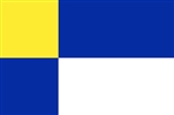
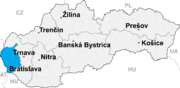
Bratislava Region
Encyclopedia
Regions of Slovakia
Since 1949 , Slovakia has been divided into a number of kraje . Their number, borders and functions have been changed several times. There are currently eight regions of Slovakia and they correspond to the EU's NUTS 3 level of local administrative units. Each kraj consists of okresy...
of Slovakia
Slovakia
The Slovak Republic is a landlocked state in Central Europe. It has a population of over five million and an area of about . Slovakia is bordered by the Czech Republic and Austria to the west, Poland to the north, Ukraine to the east and Hungary to the south...
. Its capital is Bratislava
Bratislava
Bratislava is the capital of Slovakia and, with a population of about 431,000, also the country's largest city. Bratislava is in southwestern Slovakia on both banks of the Danube River. Bordering Austria and Hungary, it is the only national capital that borders two independent countries.Bratislava...
. It is the smallest of the eight regions of Slovakia.
Geography
The region is located in the south-western part of Slovakia and has an area of 2,053 km² and a population of 622,706 (2009). The region is split by the Little CarpathiansLittle Carpathians
The Little Carpathians are a low, about 100 km long, mountain range, part of the Carpathian Mountains. The mountains are situated in Western Slovakia, covering the area from Bratislava to Nové Mesto nad Váhom, a very small part called Hundsheimer Berge is situated south of Devín Gate in...
which start in Bratislava and continue north-eastwards; these mountains separate two lowlands, the Záhorie
Záhorie
Záhorie is a region in western Slovakia bordered by the Little Carpathians in the east and the Morava River in the west. Although not an administrative region in its own right, it is one of the 21 official tourism regions in Slovakia...
lowland in the west and the fertile Danubian Lowland
Danubian Lowland
The Danubian Lowland or Danube Lowland is the name of the part of Little Alföld situated in Slovakia, located between the Danube, the Little Carpathians and all other parts of the Western Carpathians....
in the east, which grows mainly wheat and maize. Major rivers in the region are the Morava River, the Danube
Danube
The Danube is a river in the Central Europe and the Europe's second longest river after the Volga. It is classified as an international waterway....
and the Little Danube
Little Danube
The Little Danube is a branch of the river Danube in Slovakia.It splits from the main river near Bratislava, and flows more or less parallel to the Danube until it flows into the river Váh in Kolárovo...
; the last of these, together with the Danube, encircle the Žitný ostrov
Žitný ostrov
Žitný ostrov, also called Veľký Žitný ostrov to differentiate it from Malý Žitný ostrov , is a river island in southwestern Slovakia, extending from Bratislava to Komárno. It lies between the Danube and its tributary Little Danube and is a major part of the Danubian Flat...
in the south-east. There are three protected landscape areas in the region: the Little Carpathians
Little Carpathians Protected Landscape Area
Little Carpathians Protected Landscape Area is one of the 14 protected landscape areas in Slovakia. The Landscape Area is situated in the Little Carpathians, part of the Carpathian Mountains, in West Slovakia...
, Záhorie
Záhorie Protected Landscape Area
Záhorie Protected Landscape Area is the first lowland protected landscape area in Slovakia. It is located in the non-administrative Záhorie Region in West Slovakia. The Landscape Area protects 275.22 km² and is divided into two separate parts – western and north-eastern...
and Dunajské luhy
Dunajské luhy Protected Landscape Area
Dunajské luhy Protected Landscape Area is one of the youngest of the 14 protected landscape areas in Slovakia. The Landscape Area consists of five separate parts in the Danube Lowland, stretching from Bratislava in the north west, following the Danube and the borders between Slovakia and Hungary...
. The region borders Trnava Region
Trnava Region
The Trnava Region is one of the eight Slovak administrative regions.-Geography:It is located in the middlewest part of Slovakia and forms a territorial band between the Bratislava Region and the rest of Slovakia, between Austrian and Czech borders in the north and Hungarian border in the south...
in the north and east, Győr-Moson-Sopron
Gyor-Moson-Sopron
Győr-Moson-Sopron is the name of an administrative county in north-western Hungary, on the border with Slovakia and Austria. It shares borders with the Hungarian counties Komárom-Esztergom, Veszprém and Vas. The capital of Győr-Moson-Sopron county is Győr...
county in Hungary
Hungary
Hungary , officially the Republic of Hungary , is a landlocked country in Central Europe. It is situated in the Carpathian Basin and is bordered by Slovakia to the north, Ukraine and Romania to the east, Serbia and Croatia to the south, Slovenia to the southwest and Austria to the west. The...
in the south, Burgenland
Burgenland
Burgenland is the easternmost and least populous state or Land of Austria. It consists of two Statutarstädte and seven districts with in total 171 municipalities. It is 166 km long from north to south but much narrower from west to east...
in Austria
Austria
Austria , officially the Republic of Austria , is a landlocked country of roughly 8.4 million people in Central Europe. It is bordered by the Czech Republic and Germany to the north, Slovakia and Hungary to the east, Slovenia and Italy to the south, and Switzerland and Liechtenstein to the...
in the south-west and Lower Austria
Lower Austria
Lower Austria is the northeasternmost state of the nine states in Austria. The capital of Lower Austria since 1986 is Sankt Pölten, the most recently designated capital town in Austria. The capital of Lower Austria had formerly been Vienna, even though Vienna is not officially part of Lower Austria...
in the west.
History
The first known permanent settlement of the area of today's Bratislava was the Linear Pottery CultureLinear Pottery culture
The Linear Pottery culture is a major archaeological horizon of the European Neolithic, flourishing ca. 5500–4500 BC.It is abbreviated as LBK , is also known as the Linear Band Ware, Linear Ware, Linear Ceramics or Incised Ware culture, and falls within the Danubian I culture of V...
, around 5000 BC in the Neolithic
Neolithic
The Neolithic Age, Era, or Period, or New Stone Age, was a period in the development of human technology, beginning about 9500 BC in some parts of the Middle East, and later in other parts of the world. It is traditionally considered as the last part of the Stone Age...
era. Around 200 BC, the Celtic Boii tribe established an oppidum
Oppidum
Oppidum is a Latin word meaning the main settlement in any administrative area of ancient Rome. The word is derived from the earlier Latin ob-pedum, "enclosed space," possibly from the Proto-Indo-European *pedóm-, "occupied space" or "footprint."Julius Caesar described the larger Celtic Iron Age...
on the site of today's Bratislava Castle
Bratislava Castle
Bratislava Castle is the main castle of Bratislava, the capital of Slovakia.The massive rectangular building with four corner towers stands on a quite isolated rocky hill of the Little Carpathians directly above the Danube river in the middle of Bratislava...
. The Romans established their camp Gerulata
Gerulata
Gerulata was a Roman military camp located near today's Rusovce, a borough of Bratislava, Slovakia. It was part of the Roman province Pannonia and built in the 2nd century as a part of the Limes Romanus system...
on the right bank of the Danube in the 1st century and remained there until the 4th century. The area was part of the Principality of Nitra
Principality of Nitra
The Principality of Nitra also Nitrian Principality or Slovak Principality is the name for a polity of Nitra Sloviens, centered on large agglomeration, a multi-tribal centre around Nitra, Slovakia. The initially independent Principality of Nitra came into existence in the early 9th century...
and later, in the 9th century, of Great Moravia
Great Moravia
Great Moravia was a Slavic state that existed in Central Europe and lasted for nearly seventy years in the 9th century whose creators were the ancestors of the Czechs and Slovaks. It was a vassal state of the Germanic Frankish kingdom and paid an annual tribute to it. There is some controversy as...
. From the 10th century onwards, it became part of the Principality of Hungary (later the Kingdom of Hungary
Kingdom of Hungary
The Kingdom of Hungary comprised present-day Hungary, Slovakia and Croatia , Transylvania , Carpatho Ruthenia , Vojvodina , Burgenland , and other smaller territories surrounding present-day Hungary's borders...
) and almost the whole area was part of Pozsony county (the exception being three villages south of Bratislava which were part of Moson
Moson
Moson was a historic administrative county of the Kingdom of Hungary in present-day eastern Austria and northwestern Hungary, on the right side of the Danube river...
county). After the break-up of Austria-Hungary
Austria-Hungary
Austria-Hungary , more formally known as the Kingdoms and Lands Represented in the Imperial Council and the Lands of the Holy Hungarian Crown of Saint Stephen, was a constitutional monarchic union between the crowns of the Austrian Empire and the Kingdom of Hungary in...
in 1918, the county continued to exist in Czechoslovakia
Czechoslovakia
Czechoslovakia or Czecho-Slovakia was a sovereign state in Central Europe which existed from October 1918, when it declared its independence from the Austro-Hungarian Empire, until 1992...
, but it was abolished in 1928 and replaced by a new territorial unit called the "Slovak Land". During the WWII Slovak Republic, Bratislava county was restored, albeit with somewhat modified borders. After the restoration of Czechoslovakia, the pre-breakup status was restored. From 1949–1960 a unit named Bratislava Region existed, but it was replaced in 1960 by the Western Slovak Region (except from 1 July 1969 to 28 December 1970; Bratislava was partly separate from 1968, and from 1971 it was a separate region). After abolition of the regions in 1990, the current system was introduced in 1996. Since the administrative regions became autonomous in 2002, it has been governed by the Bratislava Self-Governing Region.
Demographics
Although it is the smallest region of Slovakia by area, it does not have the lowest population. The largest city is Bratislava (425,459) and the second largest is PezinokPezinok
Pezinok is a city in southwestern Slovakia. It is roughly northeast of Bratislava and has a population of 21,334 .Pezinok lies near the Little Carpathians and thrives mainly on viticulture and agriculture, as well as on brick making and ceramic production.-History:From the second half of the 10th...
(21,334). The region has a high level of urbanization
Urbanization
Urbanization, urbanisation or urban drift is the physical growth of urban areas as a result of global change. The United Nations projected that half of the world's population would live in urban areas at the end of 2008....
(83.2%). According to the 2001 census, there were 599,015 inhabitants in the region, with most of them being Slovaks
Slovaks
The Slovaks, Slovak people, or Slovakians are a West Slavic people that primarily inhabit Slovakia and speak the Slovak language, which is closely related to the Czech language.Most Slovaks today live within the borders of the independent Slovakia...
(91.2%), with minorities of Hungarians (4.6%) and Czechs (1.6%).
Economy
The economy of the Bratislava Region accounts for about a quarter of the Slovak GDP. It is marked by a strong tertiary sector, while the primary sector has a share of only around 1% and the secondary sector around 20%. Important branches include chemical, automobile, machine, electrotechnical and food industries.List of districts
- Bratislava IBratislava IBratislava I is a district in the city of Bratislava. It is identical with its sole borough, Bratislava's Old Town . It is completely surrounded by other Bratislava districts: Bratislava II, Bratislava III, Bratislava IV and Bratislava V....
- Bratislava IIBratislava IIThe Bratislava II is an okres of Bratislava in the Bratislava Region of Slovakia. It covers south-eastern part of Bratislava, including the boroughs of Ružinov, Podunajské Biskupice and Vrakuňa. It is bordered by the Bratislava I, Bratislava III, Bratislava V and Senec districts....
- Bratislava IIIBratislava IIIBratislava III is an okres of Bratislava in the Bratislava Region of Slovakia. The district includes the boroughs of Nové Mesto, Rača and Vajnory. It has an area of 75 km² and 61,418 inhabitants. It is bordered by the Bratislava I, Bratislava II, Bratislava IV, Pezinok and Senec districts....
- Bratislava IVBratislava IVBratislava IV is an okres of Bratislava in the Bratislava Region of Slovakia. It covers the north-western parts of Bratislava, including the boroughs of Devín, Devínska Nová Ves, Dúbravka, Karlova Ves, Lamač and Záhorská Bystrica....
- Bratislava VBratislava VBratislava V is an okres of Bratislava in the Bratislava Region of Slovakia. It is the largest Bratislava district and covers southern areas of Bratislava, including the boroughs of Petržalka, Jarovce, Rusovce and Čunovo. It is bordered by the Danube river to the north and east, which forms its...
- Malacky DistrictMalacky DistrictThe Malacky District is a district inthe Bratislava Region of western Slovakia. Until 1918, the district was part of the Hungarian county of Pressburg.-Municipalities:*Borinka*Gajary*Jablonové*Jakubov*Kostolište*Kuchyňa*Láb...
- Pezinok DistrictPezinok DistrictPezinok District is a district inthe Bratislava Region of western Slovakia. Until 1918, the district was part of the Hungarian county of Pressburg.-Municipalities:*Báhoň*Budmerice*Častá*Doľany*Dubová*Jablonec*Limbach...
- Senec DistrictSenec DistrictSenec District is a district inthe Bratislava Region of western Slovakia. Until 1918, the district was part of the Hungarian county of Pressburg.-Municipalities:*Bernolákovo*Blatné*Boldog*Čataj*Dunajská Lužná*Hamuliakovo...
List of municipalities and towns
There are 73 municipalities in the region, of which 7 are towns (in bold):External links
- Bratislavský samosprávny kraj Official website