
Transdanubia
Encyclopedia
- This article is about Transdanubia, the region in Hungary. Transdanubia can also refer to the 21st and 22nd districts of ViennaDistricts of ViennaThe districts of Vienna are 23 named city sections of Vienna, Austria, which are also numbered for easy reference. For centuries, district boundaries have changed...
, which are the only ones lying on the left bank of the Danube. See FloridsdorfFloridsdorfFloridsdorf is the 21st district of Vienna, Austria .Floridsdorf is located in the northern part of Vienna.The District Office and the centre of Floridsdorf are located round Am Spitz, at the junction of Prager Straße and Brünner Straße .Since 2004, Floridsdorf has had its own tower: the...
and DonaustadtDonaustadtDonaustadt is the 22nd district of Vienna, Austria .Donaustadt is the eastern fourth of Vienna.- Geography :The Donaustadt district is in the northeast part of Vienna and is the largest of the districts in area, occupying about one-quarter of the Vienna city area, 102.24 km².It borders the...
respectively.
Transdanubia is a traditional region of Hungary
Hungary
Hungary , officially the Republic of Hungary , is a landlocked country in Central Europe. It is situated in the Carpathian Basin and is bordered by Slovakia to the north, Ukraine and Romania to the east, Serbia and Croatia to the south, Slovenia to the southwest and Austria to the west. The...
.
Traditional interpretation
The borders of Transdanubia are the DanubeDanube
The Danube is a river in the Central Europe and the Europe's second longest river after the Volga. It is classified as an international waterway....
river (north and east), the Drava
Drava
Drava or Drave is a river in southern Central Europe, a tributary of the Danube. It sources in Toblach/Dobbiaco, Italy, and flows east through East Tirol and Carinthia in Austria, into Slovenia , and then southeast, passing through Croatia and forming most of the border between Croatia and...
and Mura rivers (south) and the foothills of the Alps
Alps
The Alps is one of the great mountain range systems of Europe, stretching from Austria and Slovenia in the east through Italy, Switzerland, Liechtenstein and Germany to France in the west....
roughly along the border between Hungary and Austria (west).
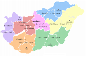
Transdanubia comprises the counties of Győr-Moson-Sopron
Gyor-Moson-Sopron
Győr-Moson-Sopron is the name of an administrative county in north-western Hungary, on the border with Slovakia and Austria. It shares borders with the Hungarian counties Komárom-Esztergom, Veszprém and Vas. The capital of Győr-Moson-Sopron county is Győr...
, Komárom-Esztergom
Komárom-Esztergom
Komárom-Esztergom is an administrative Hungarian county in Transdanubia, on the northern border with Slovakia. It shares borders with the Hungarian counties of , , and...
, Fejér
Fejér
-Geography:Geographically Fejér county is very diverse, its southern part is similar to the Great Plain , other parts are hilly . Lake Velence, a popular resort can also be found here....
, Veszprém
Veszprém (county)
Veszprém is the name of an administrative county in Hungary. Veszprém is also the name of the capital city of Veszprém county.-Veszprém county:...
, Vas
Vas
Vas is the name of an administrative county in present Hungary, and also in the former Kingdom of Hungary. The county is a part of the Centrope Project.-Geography:...
, Zala
Zala
Zala is the name of an administrative county in Hungary. Itlies in south-western Hungary. It is named after the Zala River. It shares borders with Croatia and Slovenia and the Hungarian counties Vas, Veszprém and Somogy. The capital of Zala county is Zalaegerszeg. Its area is 3784 km²...
, Somogy, Tolna
Tolna (county)
Tolna is the name of an administrative county in present Hungary and in the former Kingdom of Hungary. It lies in central Hungary, on the west bank of the river Danube. It shares borders with the Hungarian counties Somogy, Fejér, Bács-Kiskun, and Baranya. The capital of Tolna county is Szekszárd...
, Baranya
Baranya (county)
Baranya is the name of an administrative county in present Hungary, in the Baranya region, and also in the former Kingdom of Hungary ....
and the part of Pest
Pest (county)
Ethnic groups :*Magyars - 93.5%*Germans - 1.7%*Roma - 1.2%*Slovaks - 0.8%*Others - 0.5%*Unknown - 2.3%Religions :*Roman Catholic - 53%*Calvinist - 16%*Lutheran - 3.8%*Greek Catholic - 1.2%*Others - 1.3%...
that lies west of the Danube. (In the early Middle Ages the latter was known as Pilis county.)
This article deals with Transdanubia in this geographical meaning.
Territorial changes
Danube
The Danube is a river in the Central Europe and the Europe's second longest river after the Volga. It is classified as an international waterway....
and Drava
Drava
Drava or Drave is a river in southern Central Europe, a tributary of the Danube. It sources in Toblach/Dobbiaco, Italy, and flows east through East Tirol and Carinthia in Austria, into Slovenia , and then southeast, passing through Croatia and forming most of the border between Croatia and...
rivers, the western border was always identical with the political boundary of Hungary, therefore it was affected by the territorial changes of the 20th century. Before the Treaty of Trianon
Treaty of Trianon
The Treaty of Trianon was the peace agreement signed in 1920, at the end of World War I, between the Allies of World War I and Hungary . The treaty greatly redefined and reduced Hungary's borders. From its borders before World War I, it lost 72% of its territory, which was reduced from to...
in 1920 the present-day regions of Burgenland
Burgenland
Burgenland is the easternmost and least populous state or Land of Austria. It consists of two Statutarstädte and seven districts with in total 171 municipalities. It is 166 km long from north to south but much narrower from west to east...
, Prekmurje
Prekmurje
Prekmurje is a geographically, linguistically, culturally and ethnically defined region settled by Slovenes and lying between the Mur River in Slovenia and the Rába Valley in the most western part of Hungary...
and Međimurje were integral parts of Transdanubia. The three villages of Rusovce
Rusovce
Rusovce castle")) is a borough in southern Bratislava on the right bank of the Danube river, close to the Hungarian border.- History :In the 1st century, there was a Roman settlement named Gerulata in today's Rusovce area. The first preserved written reference to the settlement is from 1208. It...
, Čunovo
Cunovo
Čunovo is a small part of Bratislava, Slovakia, in the southern area near the Hungarian border. It is located close to the Gabčíkovo - Nagymaros Dams.- History :...
and Jarovce
Jarovce
Jarovce is a small borough of Bratislava, Slovakia.- History :The village was first mentioned in 1208 under the name Ban. During the Ottoman wars, many Croats settled here in the 16th century . They are still a strong minority...
also belonged to Transdanubia before the Paris Peace Treaty in 1947. Transdanubia is essentially a Hungarian geographical concept so these areas ceased to be parts of it when they were annexed by neighbouring countries.
EU regions
Transdanubia is a NUTSNomenclature of Territorial Units for Statistics
The Nomenclature of Territorial Units for Statistics or Nomenclature of Units for Territorial Statistics is a geocode standard for referencing the subdivisions of countries for statistical purposes...
territorial unit in the European Union, consisting of Central Transdanubia
Central Transdanubia
Central Transdanubia is a statistical region of Hungary. It is part of Transdanubia region. Central Transdanubia includes counties of Fejér, Komárom-Esztergom, and Veszprém....
, Western Transdanubia
Western Transdanubia
Western Transdanubia is a statistical region of Hungary. It is part of the Transdanubia region. Western Transdanubia includes the counties of Zala, Vas, and Győr-Moson-Sopron....
and Southern Transdanubia
Southern Transdanubia
Southern Transdanubia is a statistical region of Hungary. It is part of the Transdanubia region. Southern Transdanubia includes the counties of Somogy, Tolna, and Baranya. Its capital is the city of Pécs....
(see NUTS:HU
NUTS:HU
In the NUTS codes of Hungary , the three levels are:-NUTS codes:-Local administrative units:Below the NUTS levels, the two LAU levels are:...
). Pest county and Budapest
Budapest
Budapest is the capital of Hungary. As the largest city of Hungary, it is the country's principal political, cultural, commercial, industrial, and transportation centre. In 2011, Budapest had 1,733,685 inhabitants, down from its 1989 peak of 2,113,645 due to suburbanization. The Budapest Commuter...
belong to the region of Central Hungary
Central Hungary
Central Hungary is one of the seven statistical regions in Hungary . It includes and .- Administration :...
. It has an area of 37,000 km2 and a population of around 3.1 million.
Geography

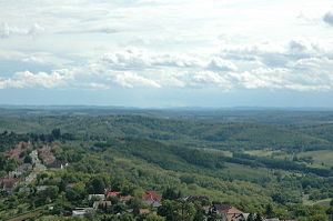
Alpokalja
Alpokalja is a geographic region in Western Hungary, which is part of the Alps. Its highest point in Hungary is Írott-kő, with 882 metres. Although there are several lower mountains, the majority of the territory is hilly...
, the Transdanubian Hills, and the Mezőföld (part of the Great Alföld). The main rivers are the Danube, Drava, Rába
Rába
The Rába is a river in southeastern Austria and western Hungary and a right tributary of the Danube. Its source is in Austria, some kilometres east of Bruck an der Mur below Heubodenhöhe Hill. It flows through the Austrian states of Styria and Burgenland, and the Hungarian counties of Vas and...
, Zala
Zala River
The Zala is a river in south-western Hungary. Its source is in the hills on the borders with Austria and Slovenia. Its length is 139 km and drains water from 2,622 square km...
, and Kapos. In the middle of Transdanubia lies the biggest sweet-water lake of Central Europe, the Lake Balaton
Lake Balaton
Lake Balaton is a freshwater lake in the Transdanubian region of Hungary. It is the largest lake in Central Europe, and one of its foremost tourist destinations. As Hungary is landlocked , Lake Balaton is often affectionately called the "Hungarian Sea"...
. Other importants lakes are the Lake Velence
Lake Velence
Lake Velence is the third largest lake in Hungary. It is a popular holiday destination among Hungarians.The lake has an area of 26 km2., one third of which is covered by the common reed...
and the Lake Fertő.
History
Historically the countiesComitatus (Kingdom of Hungary)
A county is the name of a type of administrative units in the Kingdom of Hungary and in Hungary from the 10th century until the present day....
of Transdanubia were Moson
Moson
Moson was a historic administrative county of the Kingdom of Hungary in present-day eastern Austria and northwestern Hungary, on the right side of the Danube river...
, Győr
Gyor (county)
Győr county was a historic administrative county of the Kingdom of Hungary in present-day north-western Hungary and south-western Slovakia , mostly on the right side of the Danube river...
, Sopron
Sopron (county)
Sopron is the name of a historic administrative county of the Kingdom of Hungary in present-day eastern Austria and northwestern Hungary. The capital of the county was Sopron.- Geography :...
, Vas
Vas
Vas is the name of an administrative county in present Hungary, and also in the former Kingdom of Hungary. The county is a part of the Centrope Project.-Geography:...
, Zala
Zala
Zala is the name of an administrative county in Hungary. Itlies in south-western Hungary. It is named after the Zala River. It shares borders with Croatia and Slovenia and the Hungarian counties Vas, Veszprém and Somogy. The capital of Zala county is Zalaegerszeg. Its area is 3784 km²...
, Veszprém
Veszprém (county)
Veszprém is the name of an administrative county in Hungary. Veszprém is also the name of the capital city of Veszprém county.-Veszprém county:...
, Fejér
Fejér (former county)
Fejér is the name of a historic administrative county of the Kingdom of Hungary. Its territory, which was slightly smaller than that of present Fejér county, is presently in central Hungary...
, Komárom
Komárom county
Komárom county was a historic administrative county of the Kingdom of Hungary in present-day southern Slovakia and north-western Hungary on both sides of the...
, Esztergom, Somogy, Tolna
Tolna (county)
Tolna is the name of an administrative county in present Hungary and in the former Kingdom of Hungary. It lies in central Hungary, on the west bank of the river Danube. It shares borders with the Hungarian counties Somogy, Fejér, Bács-Kiskun, and Baranya. The capital of Tolna county is Szekszárd...
and Baranya
Baranya (former county)
Baranya is the name of a historic administrative county of the Kingdom of Hungary. Its territory is presently in southern Hungary and northeastern Croatia . The capital of the county was Pécs.-Geography:Baranya county was located in Baranya region...
. They comprised the so called Districtus Trans-Danubianus from the beginnings of the 18th century. The boundaries of these counties, established by Stephen I of Hungary remained unchanged for almost 900 years until 1920.
Ancient history
Transdanubia has been populated since the Stone AgeStone Age
The Stone Age is a broad prehistoric period, lasting about 2.5 million years , during which humans and their predecessor species in the genus Homo, as well as the earlier partly contemporary genera Australopithecus and Paranthropus, widely used exclusively stone as their hard material in the...
. Between 10 BCE and 434 CE, it was part of the Roman Empire
Roman Empire
The Roman Empire was the post-Republican period of the ancient Roman civilization, characterised by an autocratic form of government and large territorial holdings in Europe and around the Mediterranean....
. With some present-day Austrian and Croatian territories, it comprised the Province of Pannonia
Pannonia
Pannonia was an ancient province of the Roman Empire bounded north and east by the Danube, coterminous westward with Noricum and upper Italy, and southward with Dalmatia and upper Moesia....
, a romanised, Latin-speaking border region with important Roman towns (Scarbantia, Aquincum
Aquincum
The ancient city of Aquincum was situated on the North-Eastern borders of the Pannonia province within the Roman Empire. The ruins of the city can be found today in Budapest, the capital city of Hungary...
, Sopianae, Gorsium, Savaria
Savaria
Savaria may refer to :-* Szombathely - a city in Hungary* Sarvaiya - a Rajput clan of India* Saawariya - a known Bollywood film....
) and rural villas.
Middle Ages
In the Age of Migrations it was occupied by the HunsHuns
The Huns were a group of nomadic people who, appearing from east of the Volga River, migrated into Europe c. AD 370 and established the vast Hunnic Empire there. Since de Guignes linked them with the Xiongnu, who had been northern neighbours of China 300 years prior to the emergence of the Huns,...
, Ostrogoths, Lombards
Lombards
The Lombards , also referred to as Longobards, were a Germanic tribe of Scandinavian origin, who from 568 to 774 ruled a Kingdom in Italy...
, Gepids, Avars
Eurasian Avars
The Eurasian Avars or Ancient Avars were a highly organized nomadic confederacy of mixed origins. They were ruled by a khagan, who was surrounded by a tight-knit entourage of nomad warriors, an organization characteristic of Turko-Mongol groups...
, Franks
Franks
The Franks were a confederation of Germanic tribes first attested in the third century AD as living north and east of the Lower Rhine River. From the third to fifth centuries some Franks raided Roman territory while other Franks joined the Roman troops in Gaul. Only the Salian Franks formed a...
and the Slavic peoples
Slavic peoples
The Slavic people are an Indo-European panethnicity living in Eastern Europe, Southeast Europe, North Asia and Central Asia. The term Slavic represents a broad ethno-linguistic group of people, who speak languages belonging to the Slavic language family and share, to varying degrees, certain...
. In 900 Pannonia was occupied by the Magyars and after 1000 became part of the Kingdom of Hungary
Kingdom of Hungary
The Kingdom of Hungary comprised present-day Hungary, Slovakia and Croatia , Transylvania , Carpatho Ruthenia , Vojvodina , Burgenland , and other smaller territories surrounding present-day Hungary's borders...
.
Transdanubia has been one of the most important regions of Hungary since the 11th century. Esztergom
Esztergom
Esztergom , is a city in northern Hungary, 46 km north-west of the capital Budapest. It lies in Komárom-Esztergom county, on the right bank of the river Danube, which forms the border with Slovakia there....
has been the ecclesiastical capital of the country since 1001 until today, and Stephen I of Hungary established his royal seat at Székesfehérvár
Székesfehérvár
Székesfehérvár is a city in central Hungary and is the 9th largest in the country. Located around southwest of Budapest. It is inhabited by 101,973 people , with 136,995 in the Székesfehérvár Subregion. The city is the centre of Fejér county and the regional centre of Central Transdanubia...
, later the coronation town of the kings. Other important medieval cities were Veszprém
Veszprém
Veszprém is one of the oldest urban areas in Hungary, and a city with county rights. It lies approximately north of the Lake Balaton. It is the administrative center of the county of the same name.-Location:...
, Pécs
Pécs
Pécs is the fifth largest city of Hungary, located on the slopes of the Mecsek mountains in the south-west of the country, close to its border with Croatia. It is the administrative and economical centre of Baranya county...
, Győr
Gyor
-Climate:-Main sights:The ancient core of the city is Káptalan Hill at the confluence of three rivers: the Danube, Rába and Rábca. Püspökvár, the residence of Győr’s bishops can be easily recognised by its incomplete tower. Győr’s oldest buildings are the 13th-century dwelling tower and the...
and Sopron
Sopron
In 1910 Sopron had 33,932 inhabitants . Religions: 64.1% Roman Catholic, 27.8% Lutheran, 6.6% Jewish, 1.2% Calvinist, 0.3% other. In 2001 the city had 56,125 inhabitants...
. After the devastating Mongol invasion (see Mongol invasion of Europe
Mongol invasion of Europe
The resumption of the Mongol invasion of Europe, during which the Mongols attacked medieval Rus' principalities and the powers of Poland and Hungary, was marked by the Mongol invasion of Rus starting in 21 December 1237...
) new castles were built, and King Béla IV of Hungary
Béla IV of Hungary
Béla IV , King of Hungary and of Croatia , duke of Styria 1254–58. One of the most famous kings of Hungary, he distinguished himself through his policy of strengthening of the royal power following the example of his grandfather Bela III, and by the rebuilding Hungary after the catastrophe of the...
established a new royal capital at Buda
Buda
For detailed information see: History of Buda CastleBuda is the western part of the Hungarian capital Budapest on the west bank of the Danube. The name Buda takes its name from the name of Bleda the Hun ruler, whose name is also Buda in Hungarian.Buda comprises about one-third of Budapest's...
, next to the Danube
Danube
The Danube is a river in the Central Europe and the Europe's second longest river after the Volga. It is classified as an international waterway....
. The region's rich medieval heritage is seen everywhere from the little village churches to the old castles, monasteries and town houses.
Early modern times
In the OttomanOttoman Empire
The Ottoman EmpireIt was usually referred to as the "Ottoman Empire", the "Turkish Empire", the "Ottoman Caliphate" or more commonly "Turkey" by its contemporaries...
era (16-17th centuries) the eastern and southern part of Transdanubia came under Turkish rule. The ever changing border ran along the Transdanubian Mountains and the southern shore of the Lake Balaton. The dangerous border was guarded by frontier-fortresses (végvár), the most important of which were Győr and Nagykanizsa. The Asian-style Ottoman rule and the constant war had devastating effects: dozens of villages were destroyed, the population was decimated and parts of the region became almost totally deserted. The territories belonging to the Royal Hungary
Royal Hungary
The Kingdom of Hungary between 1538 and 1867 was part of the lands of the Habsburg Monarchy, while outside the Holy Roman Empire.After Battle of Mohács, the country was ruled by two crowned kings . They divided the kingdom in 1538...
(except the border regions) were more lucky, because the European-like developments were continuous. Here the 17th century was the period of the Catholic Counter-reformation
Counter-Reformation
The Counter-Reformation was the period of Catholic revival beginning with the Council of Trent and ending at the close of the Thirty Years' War, 1648 as a response to the Protestant Reformation.The Counter-Reformation was a comprehensive effort, composed of four major elements:#Ecclesiastical or...
, the fights for national independence from the Habsburgs and the formation of a new, powerful Catholic aristocracy.
In 1686 the allied Habsburg, Polish and Bavarian army reconquered Buda and terminated the Ottoman rule. In the 18th century the region was slowly rebuilt, and lots of new settlers (Magyars, Germans, Slovaks, Croatians) arrived. Famous baroque castles were built to show the power of the big landowner families, for example the Esterházys in Fertőd
Fertod
Fertőd is a town located in the Győr-Moson-Sopron county of Hungary, not far from Austria. Fertőd was formed when the towns of Eszterháza and Süttör were unified, in 1950....
and the Festetics
Festetics
Festetics is a noble Hungarian family, prominent during the Austro-Hungarian Empire.On August 8, 1746, Josef and Kristof Festetics added de Tolna to their surname...
in Keszthely
Keszthely
Keszthely is a Hungarian city of 21,100 inhabitants located on the western shore of Lake Balaton. It's the second largest city by the lake after Siófok....
. The baroque townscape of the cities survived until today in Győr, Székesfehérvár, Pécs etc.
In the 19th century Trandanubia underwent a capitalist
Capitalism
Capitalism is an economic system that became dominant in the Western world following the demise of feudalism. There is no consensus on the precise definition nor on how the term should be used as a historical category...
development. Thanks to the closeness of Austria it became again the richest part of the country, and – at least after the public opinion – more "European" and Western-like than any other region of Hungary or most regions of post-communist Central Europe
Central Europe
Central Europe or alternatively Middle Europe is a region of the European continent lying between the variously defined areas of Eastern and Western Europe...
.
Modern times
People's Republic of Hungary
The People's Republic of Hungary or Hungarian People's Republic was the official state name of Hungary from 1949 to 1989 during its Communist period under the guidance of the Soviet Union. The state remained in existence until 1989 when opposition forces consolidated in forcing the regime to...
(1949–1989) new industrial cities were built at Tatabánya
Tatabánya
Tatabánya is a city of 69,988 inhabitants in north-western Hungary, in the Central Transdanubian region. It is the capital of Komárom-Esztergom County.- Location :...
, Dunaújváros
Dunaújváros
Dunaújváros is a Hungarian city in Central Transdanubia, along the Danube river. It is in Fejér county.-History:Dunaújváros is one of the newest cities of the country...
, Ajka
Ajka
Ajka is a city in Hungary with about 35,000 inhabitants. It is situated in the hills of Bakony.-History:Around 1000 BCE the area was inhabited by Celts. By the 2nd century CE the territory was conquered by the Romans...
and Komló
Komló
Komló is a town in Baranya county, Hungary. The name of the settlement is derived from the local crop of hops , an ingredient of beer. By the 18th century a depiction of this plant running up a support already featured on the herald of the town....
, and new industries and factories were established, for example Hungary's only atomic power plant at Paks
Paks
Paks is a town in Tolna county, central Hungary, on the banks of the Danube River. Paks is the home of the only Hungarian nuclear power plant, which provides about 40% the country's electricity....
. In Pécs
Pécs
Pécs is the fifth largest city of Hungary, located on the slopes of the Mecsek mountains in the south-west of the country, close to its border with Croatia. It is the administrative and economical centre of Baranya county...
uranium
Uranium
Uranium is a silvery-white metallic chemical element in the actinide series of the periodic table, with atomic number 92. It is assigned the chemical symbol U. A uranium atom has 92 protons and 92 electrons, of which 6 are valence electrons...
was mined and big industrial suburbs were built. One of the most famous plant of Socialist Hungary, the Ikarus Bus
Ikarus Bus
Ikarus is a bus manufacturer based in Budapest, Hungary. It was established in 1895 as Uhri Imre Kovács- és Kocsigyártó Üzeme .-History:...
was established in Székesfehérvár
Székesfehérvár
Székesfehérvár is a city in central Hungary and is the 9th largest in the country. Located around southwest of Budapest. It is inhabited by 101,973 people , with 136,995 in the Székesfehérvár Subregion. The city is the centre of Fejér county and the regional centre of Central Transdanubia...
. After the fall of Socialism, northern Transdanubia was more successful at adapting to the new economical situation than other parts of Hungary (except Budapest
Budapest
Budapest is the capital of Hungary. As the largest city of Hungary, it is the country's principal political, cultural, commercial, industrial, and transportation centre. In 2011, Budapest had 1,733,685 inhabitants, down from its 1989 peak of 2,113,645 due to suburbanization. The Budapest Commuter...
) and most of the foreign investment came here to help the radical economical renewal. In the 1990s Székesfehérvár
Székesfehérvár
Székesfehérvár is a city in central Hungary and is the 9th largest in the country. Located around southwest of Budapest. It is inhabited by 101,973 people , with 136,995 in the Székesfehérvár Subregion. The city is the centre of Fejér county and the regional centre of Central Transdanubia...
was counted as probably the economically most successful Hungarian town. Esztergom
Esztergom
Esztergom , is a city in northern Hungary, 46 km north-west of the capital Budapest. It lies in Komárom-Esztergom county, on the right bank of the river Danube, which forms the border with Slovakia there....
, Győr
Gyor
-Climate:-Main sights:The ancient core of the city is Káptalan Hill at the confluence of three rivers: the Danube, Rába and Rábca. Püspökvár, the residence of Győr’s bishops can be easily recognised by its incomplete tower. Győr’s oldest buildings are the 13th-century dwelling tower and the...
and Szentgotthárd
Szentgotthárd
Szentgotthárd is the westernmost town of Hungary. It is situated on the Rába River near the Austrian border, and is home to much of Hungary's small Slovene ethnic minority....
became centers of the automobile industry with the establishment of the Suzuki
Suzuki
is a Japanese multinational corporation headquartered in Hamamatsu, Japan that specializes in manufacturing compact automobiles and 4x4 vehicles, a full range of motorcycles, all-terrain vehicles , outboard marine engines, wheelchairs and a variety of other small internal combustion engines...
, Audi
Audi
Audi AG is a German automobile manufacturer, from supermini to crossover SUVs in various body styles and price ranges that are marketed under the Audi brand , positioned as the premium brand within the Volkswagen Group....
and Opel
Opel
Adam Opel AG, generally shortened to Opel, is a German automobile company founded by Adam Opel in 1862. Opel has been building automobiles since 1899, and became an Aktiengesellschaft in 1929...
factories. On the other hand some rural regions remained impoverished, especially in Southern Transdanubia and along the River Drave.
See also
- Balaton PrincipalityBalaton PrincipalityThe Principality of Lower Pannonia was a Slavic principality located in the western part of the Pannonian plain, between the rivers Danube to its east The Principality of Lower Pannonia (also called Pannonia, Lower Pannonia, Pannonian Principality, Transdanubian Principality, Slavic Pannonian...
- PannoniaPannoniaPannonia was an ancient province of the Roman Empire bounded north and east by the Danube, coterminous westward with Noricum and upper Italy, and southward with Dalmatia and upper Moesia....