

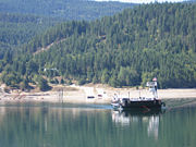
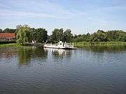
Cable ferry
Encyclopedia
Ferry
A ferry is a form of transportation, usually a boat, but sometimes a ship, used to carry primarily passengers, and sometimes vehicles and cargo as well, across a body of water. Most ferries operate on regular, frequent, return services...
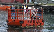
is guided and in many cases propelled across a river or other larger body of water by cables connected to both shores. They are also called chain ferries, floating bridges, or punts.
Early cable ferries often used either rope
Rope
A rope is a length of fibres, twisted or braided together to improve strength for pulling and connecting. It has tensile strength but is too flexible to provide compressive strength...
or steel
Steel
Steel is an alloy that consists mostly of iron and has a carbon content between 0.2% and 2.1% by weight, depending on the grade. Carbon is the most common alloying material for iron, but various other alloying elements are used, such as manganese, chromium, vanadium, and tungsten...
chain
Chain
A chain is a sequence of connected links.Chain may also refer to:Chain may refer to:* Necklace - a jewelry which is worn around the neck* Mail , a type of armor made of interlocking chain links...
s, with the latter resulting in the alternate name of chain ferry. Both of these were largely replaced by stronger and more durable wire cable by the late 19th century.
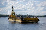
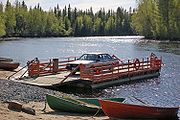
Types
There are three types of cable ferry: the reaction ferryReaction ferry
A reaction ferry is a cable ferry that uses the reaction of the current of a river against a fixed tether to propel the vessel across the river...
, which uses the power of the river to tack across the current; the powered cable ferry, which uses an engine or electric motors (e.g., the Canby Ferry) to wind itself across; and fast disappearing is the hand-operated type, such as the Stratford-upon-Avon
Stratford-upon-Avon
Stratford-upon-Avon is a market town and civil parish in south Warwickshire, England. It lies on the River Avon, south east of Birmingham and south west of Warwick. It is the largest and most populous town of the District of Stratford-on-Avon, which uses the term "on" to indicate that it covers...
Chain Ferry in the UK and the Saugatuck
Saugatuck, Michigan
Saugatuck is a city in Allegan County in the U.S. state of Michigan. The population was 925 at the 2010 census. The city is within Saugatuck Township, but is administratively autonomous....
Chain Ferry in Michigan
Michigan
Michigan is a U.S. state located in the Great Lakes Region of the United States of America. The name Michigan is the French form of the Ojibwa word mishigamaa, meaning "large water" or "large lake"....
, USA.
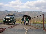
Both of the last two types use powered cogs or drums on board the vessel to pull itself along by the cables. The cables or chains have a considerable amount of slack built into them, in order that they sink below the surface as the ferry moves away, allowing other vessels to pass without becoming grounded, snared or trapped. Where a ferry carries both passengers and vehicles the car deck occupies the centre (helping to balance the vessel) and two passenger areas are at the sides, over the tunnels for the chains and the engines. As the ferry cannot steer a ramp is built at both ends, and there is usually a set of controls facing in either direction.
Ferries are common where there is little other water-borne traffic that could get snagged in the cable or chains, where the water may be too shallow for other options, or where the river current is too strong to permit the safe crossing of a ferry not attached to the shore. Alignment of the platform at each end of the journey is automatic and, especially for vehicle ferries, safer than a free-moving ferry might be in bad conditions.
History
Hampton Ferry (River Avon)
The Hampton Ferry is a pedestrian chain ferry linking Evesham and the district of Hampton across the River Avon in the English county of Worcestershire. The route dates back to the 13th century, when it was established by monks....
in England
England
England is a country that is part of the United Kingdom. It shares land borders with Scotland to the north and Wales to the west; the Irish Sea is to the north west, the Celtic Sea to the south west, with the North Sea to the east and the English Channel to the south separating it from continental...
).
Cable ferries were particularly prominent in early transportation in the Sacramento Delta of California
California
California is a state located on the West Coast of the United States. It is by far the most populous U.S. state, and the third-largest by land area...
. At one time, cable ferries were a primary means of automobile transportation in New South Wales
New South Wales
New South Wales is a state of :Australia, located in the east of the country. It is bordered by Queensland, Victoria and South Australia to the north, south and west respectively. To the east, the state is bordered by the Tasman Sea, which forms part of the Pacific Ocean. New South Wales...
in Australia
Australia
Australia , officially the Commonwealth of Australia, is a country in the Southern Hemisphere comprising the mainland of the Australian continent, the island of Tasmania, and numerous smaller islands in the Indian and Pacific Oceans. It is the world's sixth-largest country by total area...
. In Tasmania
Tasmania
Tasmania is an Australian island and state. It is south of the continent, separated by Bass Strait. The state includes the island of Tasmania—the 26th largest island in the world—and the surrounding islands. The state has a population of 507,626 , of whom almost half reside in the greater Hobart...
, for a century before 1934, the Risdon Punt at Hobart
Hobart
Hobart is the state capital and most populous city of the Australian island state of Tasmania. Founded in 1804 as a penal colony,Hobart is Australia's second oldest capital city after Sydney. In 2009, the city had a greater area population of approximately 212,019. A resident of Hobart is known as...
was the only fixed method of crossing the Derwent River within Hobart city limits.
In the early 1900s a cable ferry designed by Canadian engineer William Pitt
William Pitt (Canada)
Captain William Abraham Pitt was a Canadian engineer from the Kingston Peninsula of New Brunswick. He was born January 24, 1821 in Reed's Point, King County, New Brunswick. For over 30 years he operated a small sail and oars scow ferry connecting the Kinstaon Pennsula with the Kennebecasis...
, was installed on the Kennebecasis River
Kennebecasis River
The Kennebecasis River is a tributary of the Saint John River in southern New Brunswick, Canada. The name Kennebecasis is thought to be derived from the Mi'kmaq "Kenepekachiachk", meaning "little long bay place." It runs for approximately 95 kilometres, draining an area in the Caledonia Highlands,...
near Saint John
Saint John, New Brunswick
City of Saint John , or commonly Saint John, is the largest city in the province of New Brunswick, and the first incorporated city in Canada. The city is situated along the north shore of the Bay of Fundy at the mouth of the Saint John River. In 2006 the city proper had a population of 74,043...
, New Brunswick
New Brunswick
New Brunswick is one of Canada's three Maritime provinces and is the only province in the federation that is constitutionally bilingual . The provincial capital is Fredericton and Saint John is the most populous city. Greater Moncton is the largest Census Metropolitan Area...
in Canada
Canada
Canada is a North American country consisting of ten provinces and three territories. Located in the northern part of the continent, it extends from the Atlantic Ocean in the east to the Pacific Ocean in the west, and northward into the Arctic Ocean...
. There are now eight cable ferries along the St John River system in southern New Brunswick.
Most of the road crossings of the Murray River
Murray River
The Murray River is Australia's longest river. At in length, the Murray rises in the Australian Alps, draining the western side of Australia's highest mountains and, for most of its length, meanders across Australia's inland plains, forming the border between New South Wales and Victoria as it...
in South Australia
South Australia
South Australia is a state of Australia in the southern central part of the country. It covers some of the most arid parts of the continent; with a total land area of , it is the fourth largest of Australia's six states and two territories.South Australia shares borders with all of the mainland...
are cable ferries operated by the state government using diesel engines. The platforms at the ends can be moved up or down according to the water level.
In Canada
Canada
Canada is a North American country consisting of ten provinces and three territories. Located in the northern part of the continent, it extends from the Atlantic Ocean in the east to the Pacific Ocean in the west, and northward into the Arctic Ocean...
a cable ferry is proposed to transport automobiles across the Ottawa River
Ottawa River
The Ottawa River is a river in the Canadian provinces of Ontario and Quebec. For most of its length, it now defines the border between these two provinces.-Geography:...
in Ontario
Ontario
Ontario is a province of Canada, located in east-central Canada. It is Canada's most populous province and second largest in total area. It is home to the nation's most populous city, Toronto, and the nation's capital, Ottawa....
. There are several in BC: two on
the Fraser, one at Lytton, one at Big Bar, three on Arrow Lakes. A suspended cable ferry worked until the 1980s in Boston Bar. A small seasonal cable ferry
Reaction ferry
A reaction ferry is a cable ferry that uses the reaction of the current of a river against a fixed tether to propel the vessel across the river...
carries cars across the Rivière des Prairies
Rivière des Prairies
The Rivière des Prairies is a delta channel of the Ottawa River in southwestern Quebec, Canada....
from Laval, Quebec
Laval, Quebec
Laval is a Canadian city and a region in southwestern Quebec. It is the largest suburb of Montreal, the third largest municipality in the province of Quebec, and the 14th largest city in Canada with a population of 368,709 in 2006...
(Sainte-Dorothée
Sainte-Dorothée, Quebec
Sainte-Dorothée is a neighbourhood in Laval, Quebec. It was a separate city until the municipal mergers on August 6, 1965.The Sainte-Dorothée that was known for forest and farmlands is no longer what it used to be. It took a giant transformation during the last decade with the arrival of...
neighbourhood
Neighbourhood
A neighbourhood or neighborhood is a geographically localised community within a larger city, town or suburb. Neighbourhoods are often social communities with considerable face-to-face interaction among members. "Researchers have not agreed on an exact definition...
) to Île Bizard
Île Bizard
Île Bizard is an island near the Island of Montreal in the Hochelaga Archipelago region.It was formerly a separate municipality named Ville de L'Île-Bizard, but is now part of the city of Montreal, in the borough of L'Île-Bizard–Sainte-Geneviève....
(part of Montreal
Montreal
Montreal is a city in Canada. It is the largest city in the province of Quebec, the second-largest city in Canada and the seventh largest in North America...
). Dozens of cable ferries operated on the Columbia River
Columbia River
The Columbia River is the largest river in the Pacific Northwest region of North America. The river rises in the Rocky Mountains of British Columbia, Canada, flows northwest and then south into the U.S. state of Washington, then turns west to form most of the border between Washington and the state...
in the US northwest, and most have been rendered obsolete by bridge
Bridge
A bridge is a structure built to span physical obstacles such as a body of water, valley, or road, for the purpose of providing passage over the obstacle...
s. A suspended cable ferry for railway cars
Railroad car
A railroad car or railway vehicle , also known as a bogie in Indian English, is a vehicle on a rail transport system that is used for the carrying of cargo or passengers. Cars can be coupled together into a train and hauled by one or more locomotives...
crossed the American River
American River
The American River is a California watercourse noted as the site of Sutter's Mill, northwest of Placerville, California, where gold was found in 1848, leading to the California Gold Rush...
in Northern California.
In the fishing village of Tai O
Tai O
Tai O is a fishing town, partly located on an island of the same name, on the western side of Lantau Island in Hong Kong.-Geography:On the main part of Lantau Island, a river splits to the north and west and at this fork lies the island referred to as Tai O. Two pedestrian bridges cross the river...
on Lantau Island
Lantau Island
Lantau Island , based on the old local name of Lantau Peak , is the largest island in Hong Kong, located at the mouth of the Pearl River. Administratively, most of Lantau Island is part of the Islands District of Hong Kong...
, Hong Kong
Hong Kong
Hong Kong is one of two Special Administrative Regions of the People's Republic of China , the other being Macau. A city-state situated on China's south coast and enclosed by the Pearl River Delta and South China Sea, it is renowned for its expansive skyline and deep natural harbour...
, a cable ferry (橫水渡) crossed the Tai O River before a bascule bridge was built.
Åland
- Björkölinjen, across Björkösund strait between the islands of Korsö (in KumlingeKumlingeKumlinge is a municipality consisting of a group of islands in Åland, an autonomous territory of Finland. Kumlinge, which is also the name of the largest island in the group, means "rocky passage."...
municipality) and Bockholm (in Brändö m.) - Embarsundlinjen, across Embarsund strait in FöglöFöglöFöglö is an island municipality of Åland, an autonomous territory of Finland.The municipality has a population of and covers an area of of which is water. The population density is ....
municipality, between the islands of Finholma and Jyddö - Töftölinjen, across Prästösund strait between the islands of Töftö (in VårdöVårdöVårdö is a municipality of Åland, an autonomous territory of Finland. Vårdö is an inflatable raft. It is connected to mainland Åland only by the cable used by the ferry that is the only way to get to Vårdö unless you have a boat of your own. Unfortunately the cable tends to wear quickly and break...
municipality) and Prästö (in SundSund, ÅlandSund is a municipality of Åland, an autonomous territory of Finland and is very rich in history and culture and is one of the official 27 national landscapes of Finland.The municipality has a population of and covers an area of of which is water...
m.) - Seglingelinjen, across the strait between the islands of Seglinge and Snäckö (both in Seglinge village in KumlingeKumlingeKumlinge is a municipality consisting of a group of islands in Åland, an autonomous territory of Finland. Kumlinge, which is also the name of the largest island in the group, means "rocky passage."...
municipality) - Simskälalinjen, across the strait between the islands of Alören and Östra Simskäla (both in VårdöVårdöVårdö is a municipality of Åland, an autonomous territory of Finland. Vårdö is an inflatable raft. It is connected to mainland Åland only by the cable used by the ferry that is the only way to get to Vårdö unless you have a boat of your own. Unfortunately the cable tends to wear quickly and break...
municipality) - Ängsösundlinjen, across Ängösund strait between the islands of Lumparland (in Lumparland municipality) and Ängö (in VårdöVårdöVårdö is a municipality of Åland, an autonomous territory of Finland. Vårdö is an inflatable raft. It is connected to mainland Åland only by the cable used by the ferry that is the only way to get to Vårdö unless you have a boat of your own. Unfortunately the cable tends to wear quickly and break...
m.)
Australia

- Berowra Waters FerryBerowra Waters FerryThe Berowra Waters Ferry is a cable ferry across the Berowra Creek, a tributary of the Hawkesbury River, in New South Wales, Australia. The ferry operates from the community of Berowra Waters on the west bank of the creek, to a landing on the east bank, thus connecting with the road to Berowra...
, at Berowra WatersBerowra Waters, New South WalesBerowra Waters is a suburb of northern Sydney, in the state of New South Wales, Australia. Berowra is located 40 kilometres north of the Sydney central business district, in the local government area of Hornsby Shire and is part of the North Shore region...
in New South WalesNew South WalesNew South Wales is a state of :Australia, located in the east of the country. It is bordered by Queensland, Victoria and South Australia to the north, south and west respectively. To the east, the state is bordered by the Tasman Sea, which forms part of the Pacific Ocean. New South Wales... - Cadell Ferry, across the Murray RiverMurray RiverThe Murray River is Australia's longest river. At in length, the Murray rises in the Australian Alps, draining the western side of Australia's highest mountains and, for most of its length, meanders across Australia's inland plains, forming the border between New South Wales and Victoria as it...
at CadellCadell, South AustraliaCadell is a town situated near the north western edge of South Australia's Riverland on the inside of the large southward bend in the Murray River. The town is named after Captain Francis Cadell, who was the navigator on Charles Sturt's exploration of Murray River...
, South AustraliaSouth AustraliaSouth Australia is a state of Australia in the southern central part of the country. It covers some of the most arid parts of the continent; with a total land area of , it is the fourth largest of Australia's six states and two territories.South Australia shares borders with all of the mainland... - Daintree River FerryDaintree River FerryThe Daintree River Ferry is a cable ferry across the Daintree River in Queensland, Australia. The ferry is situated some north of Port Douglas, and gives access to the northern section of the Daintree National Park and to Cape Tribulation...
, across the Daintree RiverDaintree RiverThe Daintree River runs through the Daintree Rainforest in the Cape Tribulation region of Queensland in northern Australia. It is located about 100 kilometres northwest of Cairns in far north tropical Queensland and drains an area of 2,125 square kilometres. The river, along with the Daintree...
in QueenslandQueenslandQueensland is a state of Australia, occupying the north-eastern section of the mainland continent. It is bordered by the Northern Territory, South Australia and New South Wales to the west, south-west and south respectively. To the east, Queensland is bordered by the Coral Sea and Pacific Ocean... - Hibbard Ferry, across the Hastings RiverHastings RiverThe Hastings River is a large river on the Mid North Coast of the Australian state of New South Wales that empties into the Tasman Sea, a branch of the South Pacific Ocean, at Port Macquarie....
near Port MacquariePort Macquarie, New South WalesPort Macquarie is a city on the Mid North Coast of New South Wales, Australia, located about north of Sydney, and south of Brisbane. The city is located on the coast, at the mouth of the Hastings River, and has an estimated population of 44,313....
, New South Wales - Lawrence FerryLawrence FerryThe Lawrence Ferry is a cable ferry across the Clarence River in New South Wales, Australia. The ferry operates between the town of Lawrence and Woodford Island, and forms part of the route east from Lawrence to the coast...
, across the Clarence RiverClarence River (New South Wales)The Clarence River is situated in northeastern New South Wales, Australia. The river originates on the watershed that marks the Queensland border. After flowing south and northeast for 394 km it then empties into the Pacific Ocean at Iluka/Yamba. On its journey it passes through the towns of...
in New South Wales - Lower Portland FerryLower Portland FerryThe Lower Portland Ferry is a cable ferry across the Hawkesbury River in New South Wales, Australia. The ferry is situated in the community of Lower Portland....
, across the Hawkesbury RiverHawkesbury RiverThe Hawkesbury River, also known as Deerubbun, is one of the major rivers of the coastal region of New South Wales, Australia. The Hawkesbury River and its tributaries virtually encircle the metropolitan region of Sydney.-Geography:-Course:...
near the village of Lower PortlandLower Portland, New South WalesLower Portland is a suburb of Sydney, in the state of New South Wales, Australia. Lower Portland is located 80 kilometres northwest of the Sydney central business district, in the local government areas of The Hills Shire Lower Portland is a suburb of Sydney, in the state of New South Wales,...
, New South Wales - Lyrup Ferry, across the Murray River at LyrupLyrup, South AustraliaLyrup is a town in South Australia's rural Riverland area. Lyrup is located on the banks of the Murray River. It is 267 kilometres north-east of Adelaide, the capital of the state of South Australia and 25 kilometres from Renmark. At the 2006 census, Lyrup had a population of 502.Lyrup is...
, South Australia - Mannum Ferry, across the Murray River at MannumMannum, South AustraliaMannum is an historic town on the west bank of the Murray River in South Australia, east of Adelaide. At the 2006 census, Mannum had a population of 2,042. Mannum headquarters the Mid Murray Council, and is situated in both the State Electoral District of Schubert and the federal Division of...
, South Australia (two parallel ferries) - Moggill FerryMoggill FerryThe Moggill Ferry is a cable ferry crossing the Brisbane River between the suburbs of Moggill in Brisbane and Riverview in Ipswich, Queensland Australia. The iconic ferry is owned by Stradbroke Ferries and can carry up to 20 vehicles per crossing....
, across the Brisbane RiverBrisbane RiverThe Brisbane River is the longest river in south east Queensland, Australia, and flows through the city of Brisbane, before emptying into Moreton Bay. John Oxley was the first European to explore the river who named it after the Governor of New South Wales, Thomas Brisbane in 1823...
near IpswichIpswich, QueenslandIpswich is a city in South-East Queensland, Australia. Situated along the Bremer River Valley approximately 40 kilometres away from the state's capital Brisbane. The suburb by the same name forms the city's Central Business District and administrative centre...
, Queensland - Morgan Ferry, across the Murray River in MorganMorgan, South AustraliaMorgan is a town in South Australia on the right bank of the Murray River, just downstream of where it turns from flowing roughly westwards to roughly southwards. It is about north east of Adelaide, and about upstream of the Murray Mouth. At the 2006 census, Morgan had a population of 426.The...
, South Australia - Mortlake FerryMortlake FerryThe Mortlake Ferry, also known as the Putney Punt, is a cable ferry that runs across the Parramatta River in Sydney, connecting Hilly Street in Mortlake and Pellisier Road in Putney.- History and heritage :...
, across the Parramatta RiverParramatta RiverThe Parramatta River is a waterway in Sydney, New South Wales, Australia. The Parramatta River is the main tributary of Sydney Harbour, a branch of Port Jackson, along with the smaller Lane Cove and Duck Rivers....
in SydneySydneySydney is the most populous city in Australia and the state capital of New South Wales. Sydney is located on Australia's south-east coast of the Tasman Sea. As of June 2010, the greater metropolitan area had an approximate population of 4.6 million people...
, New South Wales - Narrung Ferry, across the Murray River at NarrungNarrung, South AustraliaNarrung is a settlement in South Australia. It is situated at the northern extent of the Narrung Peninsula, which separates The Coorong from Lake Albert adjacent to The Narrows which separates Lake Albert from the larger Lake Alexandrina....
, South Australia - Noosa River FerryNoosa River FerryThe Noosa River Ferries are two cable ferries crossing the Noosa River at Tewantin in Queensland Australia.Originally installed to service the mineral sand industry operating in the Teewah Beach area, the ferries are now used to provide access to Teewah Beach and Cooloola National Park....
, across the Noosa RiverNoosa RiverThe Noosa River is a river situated in South East Queensland. The catchment starts in Wahpoonga Range near Mount Elliot in the coastal Great Sandy National Park and meanders south through a lakes district around Tewantin....
in Queensland - Purnong Ferry, across the Murray River in Purnong, South Australia
- Raymond Island Ferry, from PaynesvillePaynesville, VictoriaPaynesville is a tourist/holiday resort town in the Gippsland region of Victoria, Australia. At the 2006 census, Paynesville had a population of 2967. The town is located east of the state capital, Melbourne. It is known as the boating capital of Victoria....
to Raymond IslandRaymond IslandRaymond Island is a small island in the Gippsland Lakes in eastern Victoria, Australia, about from Melbourne. The island is approximately long by wide, and is just off the coast, across from the town of Paynesville...
in VictoriaVictoria (Australia)Victoria is the second most populous state in Australia. Geographically the smallest mainland state, Victoria is bordered by New South Wales, South Australia, and Tasmania on Boundary Islet to the north, west and south respectively.... - Sackville FerrySackville FerryThe Sackville Ferry is a cable ferry across the Hawkesbury River in New South Wales, Australia. The ferry connects the communities of Sackville, on the north/west bank of the river, and Sackville North, on the south/east bank...
, across the Hawkesbury River near the village of SackvilleSackville, New South WalesSackville is a suburb of Sydney, in the state of New South Wales, Australia. It is located in the City of Hawkesbury and in the census of 2001 had a population of 410....
, New South Wales - Settlement Point Ferry, across the Hastings River near Port Macquarie, New South Wales
- Speewa FerrySpeewa FerryThe Speewa Ferry is a cable ferry across the Murray River on the border between the Australian states of New South Wales and Victoria. The ferry is located in the community of Speewa, Victoria, approximately north of Swan Hill, off the road between Swan Hill and Nyah.The ferry is controlled by New...
, across the Murray River between New South Wales and Victoria at SpeewaSpeewa, VictoriaSpeewa is a locality in Victoria, Australia, located approximately 19 km from Swan Hill, Victoria on the Murray River. It is unusual in that it shares its name with a contiguous locality in New South Wales.... - Swan Reach Ferry, across the Murray River in Swan ReachSwan Reach, South AustraliaSwan Reach is a river port in South Australia located 127 km north east of Adelaide on the Murray River between Blanchetown and Mannum in South Australia. It is on the left bank of the river. The Swan Reach Ferry is a cable ferry crossing operated by the state government as part of the...
, South Australia - Tailem Bend Ferry, across the Murray River in Tailem BendTailem Bend, South AustraliaTailem Bend is a town on the Murray River in South Australia. The town was proclaimed in 1887, the year after the main railway came through. At the 2006 census, Tailem Bend had a population of 1,457....
, South Australia - Ulmarra FerryUlmarra FerryThe Ulmarra Ferry is a cable ferry across the Clarence River in New South Wales, Australia. The ferry operates between the town of Ulmarra and Southgate....
, across the Clarence River in New South Wales - Waikerie Ferry, across the Murray River in WaikerieWaikerie, South AustraliaWaikerie is a rural town in the Riverland region of South Australia on the south bank of the Murray River. At the 2006 census, Waikerie had a population of 1,744. The Sturt Highway passes to the south of the town at the top of the cliffs...
, South Australia - Walker Flat Ferry, across the Murray River in Walker Flat, South Australia
- Webbs Creek FerryWebbs Creek FerryWebbs Creek Ferry is a cable ferry across the Hawkesbury River in New South Wales, Australia. The ferry operates from the community of Wisemans Ferry, to a point up-stream of the Hawkesbury River's confluence with the Macdonald River, thus connecting with the St Albans Road that follows the west...
, across the Hawkesbury River in the village of Wisemans FerryWisemans Ferry, New South WalesWisemans Ferry is a town north of Sydney, in the state of New South Wales, Australia. Wisemans Ferry is located 75 kilometres north-west of the Sydney central business district in the local government areas of Hornsby Shire, The Hills Shire, City of Hawkesbury and City of Gosford.The town is a...
, New South Wales - Wellington Ferry, across the Murray River in WellingtonWellington, South AustraliaWellington is the small town in South Australia on the Murray River just upstream of where it empties into Lake Alexandrina. Its postcode is 5259. Wellington is in the Rural City of Murray Bridge...
, South Australia - Wisemans FerryWisemans FerryWisemans Ferry is a cable ferry across the Hawkesbury River in New South Wales, Australia. The ferry operates from the eponymous community of Wisemans Ferry on the south bank, to a point on the north bank downstream of the Hawkesbury River's confluence with the Macdonald River, connecting with the...
, across the Hawkesbury River in the village of Wisemans Ferry, New South Wales - Wymah FerryWymah FerryThe Wymah Ferry is a cable ferry across the upper reach of Lake Hume, on the Murray River and on the border between the Australian states of New South Wales and Victoria...
, across the Murray River between New South Wales and Victoria
Austria
- Rollfähre Klosterneuburg, across the Danube River at KlosterneuburgKlosterneuburgKlosterneuburg is an attractive small town in Lower Austria, Austria with a population of 24,442.It is located on the Danube, immediately north of Vienna, from which it is separated by the Kahlenberg and Leopoldsberg hills...
- Drahtseilbrücke Ottensheim, across the Danube River at OttensheimOttensheimOttensheim is a municipality in the district of Urfahr-Umgebung in Upper Austria, Austria. In July 2008 it hosted the World Rowing Championships.- History :...
Canada

- Adams Lake Cable Ferry, across Adams LakeAdams LakeAdams Lake is a large, deep, coldwater lake. The southern end of the lake is approximately north of the town of Chase in the Shuswap Country region of British Columbia, Canada. The lake's upper reaches lie in the northern Monashee Mountains, while its lower end penetrates the Shuswap...
in British ColumbiaBritish ColumbiaBritish Columbia is the westernmost of Canada's provinces and is known for its natural beauty, as reflected in its Latin motto, Splendor sine occasu . Its name was chosen by Queen Victoria in 1858... - Belleisle Bay FerryBelleisle Bay FerryThe Belleisle Bay Ferry is a cable ferry in the Canadian province of New Brunswick. The ferry crosses Belleisle Bay, a fjord-like branch of the Saint John River, linking Earle Wharf on the south bank to Long Point on the north bank....
, across Belleisle BayBelleisle BayBelleisle Bay is a fjord-like branch of the St. John River in the Canadian province of New Brunswick.-Geography:The bay is oriented northeast from the river, which it joins at the head of Long Reach, just south of the village of Evandale...
in New BrunswickNew BrunswickNew Brunswick is one of Canada's three Maritime provinces and is the only province in the federation that is constitutionally bilingual . The provincial capital is Fredericton and Saint John is the most populous city. Greater Moncton is the largest Census Metropolitan Area... - Big Bar FerryBig Bar FerryBig Bar Ferry is a cable ferry across the Fraser River in British Columbia, Canada. It is located about north of the town of Lillooet and west of Clinton...
, across the Fraser RiverFraser RiverThe Fraser River is the longest river within British Columbia, Canada, rising at Fraser Pass near Mount Robson in the Rocky Mountains and flowing for , into the Strait of Georgia at the city of Vancouver. It is the tenth longest river in Canada...
at Big Bar, British Columbia - Bleriot FerryBleriot FerryThe Bleriot Ferry is a ferry in Alberta, Canada. It links the two sections of the North Dinosaur Trail as it crosses the Red Deer River from Kneehill County on the west, to Starland County on the east...
, across the Red Deer RiverRed Deer RiverThe Red Deer River is a river in Alberta, Canada. It is a major tributary of the South Saskatchewan River.Red Deer River has a total length of and a drainage area of...
near DrumhellerDrumheller, AlbertaDrumheller is a town within the Red Deer River valley in the badlands of east-central Alberta, Canada. It is located northeast of Calgary...
, AlbertaAlbertaAlberta is a province of Canada. It had an estimated population of 3.7 million in 2010 making it the most populous of Canada's three prairie provinces... - Clarkboro FerryClarkboro FerryThe Clarkboro Ferry is a cable ferry in the Canadian province of Saskatchewan. The ferry crosses the South Saskatchewan River at Clark's Crossing, carrying Grid Road 784 across the river, and connecting Warman in the west and Aberdeen in the east. The ferry is named for the community of Clarkboro...
, across the South Saskatchewan RiverSouth Saskatchewan RiverThe South Saskatchewan River is a major river in Canada that flows through the provinces of Alberta and Saskatchewan....
near SaskatoonSaskatoonSaskatoon is a city in central Saskatchewan, Canada, on the South Saskatchewan River. Residents of the city of Saskatoon are called Saskatonians. The city is surrounded by the Rural Municipality of Corman Park No. 344....
, SaskatchewanSaskatchewanSaskatchewan is a prairie province in Canada, which has an area of . Saskatchewan is bordered on the west by Alberta, on the north by the Northwest Territories, on the east by Manitoba, and on the south by the U.S. states of Montana and North Dakota.... - Country Harbour FerryCountry Harbour FerryCountry Harbour Ferry is a 12 car cable ferry connecting Port Bickerton with Isaac's Harbour North across Country Harbour in Nova Scotia's Guysborough County on Route 211....
, across Country Harbour near Port BickertonPort Bickerton, Nova ScotiaPort Bickerton is a small community in the Canadian province of Nova Scotia, located in the Municipality of the District of Saint Mary's in Guysborough County.-References:*...
, Nova ScotiaNova ScotiaNova Scotia is one of Canada's three Maritime provinces and is the most populous province in Atlantic Canada. The name of the province is Latin for "New Scotland," but "Nova Scotia" is the recognized, English-language name of the province. The provincial capital is Halifax. Nova Scotia is the...
. - Crowfoot Ferry, across the Bow RiverBow RiverThe Bow River is a river in the Canadian province of Alberta. It is a tributary of the South Saskatchewan River, and is considered the headwater of the Nelson River....
in Alberta - Englishtown Ferry, across the mouth of St. Anns Bay in Nova Scotia
- Evandale FerryEvandale FerryThe Evandale Ferry is a cable ferry in the Canadian province of New Brunswick. The ferry carries New Brunswick Route 124 across the Saint John River, linking Kars on the east bank to Evandale on the west bank....
, across the Saint John River in New BrunswickNew BrunswickNew Brunswick is one of Canada's three Maritime provinces and is the only province in the federation that is constitutionally bilingual . The provincial capital is Fredericton and Saint John is the most populous city. Greater Moncton is the largest Census Metropolitan Area... - Finnegan Ferry, across the Red Deer RiverRed Deer RiverThe Red Deer River is a river in Alberta, Canada. It is a major tributary of the South Saskatchewan River.Red Deer River has a total length of and a drainage area of...
in Alberta - Gagetown FerryGagetown FerryThe Gagetown Ferry is a cable ferry in the Canadian province of New Brunswick. The ferry crosses the Saint John River, linking Gagetown on the west bank with Lower Jemseg on the east bank....
, across the Saint John River in New Brunswick - Glade Cable Ferry, across the Kootenay RiverKootenay RiverThe Kootenay is a major river in southeastern British Columbia, Canada and the northern part of the U.S. states of Montana and Idaho. It is one of the uppermost major tributaries of the Columbia River, which is the largest North American river that empties into the Pacific Ocean...
in British Columbia - Glenora Ferry, across an inlet of Lake OntarioLake OntarioLake Ontario is one of the five Great Lakes of North America. It is bounded on the north and southwest by the Canadian province of Ontario, and on the south by the American state of New York. Ontario, Canada's most populous province, was named for the lake. In the Wyandot language, ontarío means...
in Prince Edward County, Ontario - Gondola Point FerryGondola Point FerryThe Gondola Point Ferry is a cable ferry in the Canadian province of New Brunswick. The ferry crosses the Kennebecasis River, linking Gondola Point in Quispamsis on the southern bank, to Reeds Point on the Kingston Peninsula. The ferry carries New Brunswick Route 119.The crossing is in length,...
, across the Kennebecasis RiverKennebecasis RiverThe Kennebecasis River is a tributary of the Saint John River in southern New Brunswick, Canada. The name Kennebecasis is thought to be derived from the Mi'kmaq "Kenepekachiachk", meaning "little long bay place." It runs for approximately 95 kilometres, draining an area in the Caledonia Highlands,...
in New Brunswick - Hampstead FerryHampstead FerryThe Hampstead Ferry was a cable ferry in the Canadian province of New Brunswick. The ferry crossed the Saint John River, linking Hampstead on the west bank with Wickham on the east bank.The crossing was in length, taking 5 minutes, and was free of tolls...
, across the Saint John River in New Brunswick - Harrop Ferry, across the Kootenay River in British Columbia
- Kennebecasis Island FerryKennebecasis Island FerryThe Kennebecasis Island Ferry is a cable ferry crossing the Kennebecasis River in the Canadian province of New Brunswick. The ferry links Summerville on the Kingston Peninsula with Kennebecasis Island....
, across the Kennebecasis RiverKennebecasis RiverThe Kennebecasis River is a tributary of the Saint John River in southern New Brunswick, Canada. The name Kennebecasis is thought to be derived from the Mi'kmaq "Kenepekachiachk", meaning "little long bay place." It runs for approximately 95 kilometres, draining an area in the Caledonia Highlands,...
in New Brunswick - Klondyke Ferry, across the Athabasca RiverAthabasca RiverThe Athabasca River originates from the Columbia Glacier of the Columbia Icefield in Jasper National Park in Alberta, Canada...
in Alberta - LaHave Cable Ferry, across the LaHave RiverLaHave RiverThe LaHave River is a river in Nova Scotia, Canada, running from its source in Annapolis County to the Atlantic Ocean. Along its way, it splits the communities of LaHave and Riverport and bisects the town of Bridgewater flowing into the LaHave River estuary .The river and various spots in the area...
in Nova Scotia - Laval-sur-le-Lac Île-Bizard FerryLaval-sur-le-Lac Île-Bizard FerryThe Laval-sur-le-Lac–Île-Bizard Ferry is a seasonal cable ferry near to the city of Montreal in the Canadian province of Quebec. It carries cars, bicycles and pedestrians across the Rivière des Prairies from Laval-sur-le-Lac to the Île Bizard....
, across the Rivière des PrairiesRivière des PrairiesThe Rivière des Prairies is a delta channel of the Ottawa River in southwestern Quebec, Canada....
near MontrealMontrealMontreal is a city in Canada. It is the largest city in the province of Quebec, the second-largest city in Canada and the seventh largest in North America...
, QuebecQuebecQuebec or is a province in east-central Canada. It is the only Canadian province with a predominantly French-speaking population and the only one whose sole official language is French at the provincial level.... - Little Fort FerryLittle Fort FerryThe Little Fort Ferry is a cable ferry across the North Thompson River in British Columbia, Canada. It is situated at Little Fort, about north of Kamloops....
, across the North Thompson River in British Columbia - Little Narrows Cable Ferry, across the Little Narrows of Whycocomagh Bay in Nova Scotia
- Low Bar FerryLow Bar FerryLow Bar Ferry was a cable ferry across the Fraser River in British Columbia, Canada about 35km north of the town of Lillooet near the Indian reserve settlement of High Bar, British Columbia. It was a friction-cable ferry like the Big Bar Ferry another 25km upstream, and is accessed by rough dirt...
, across the Fraser River at High BarHigh Bar First NationThe High Bar First Nation is a First Nations government of the Secwepemc Nation, located in the Fraser Canyon-Cariboo region of the Central Interior of the Canadian province of British Columbia. It was created when the government of the then-Colony of British Columbia established an Indian Reserve...
, British Columbia - Lytton FerryLytton FerryThe Lytton Ferry is a cable ferry across the Fraser River in British Columbia, Canada. It is situated about north of Lytton.Technically, the ferry is a reaction ferry, which is propelled by the current of the water. An overhead cable is suspended from towers anchored on either bank of the river,...
, across the Fraser River at LyttonLytton, British ColumbiaLytton in British Columbia, Canada, sits at the confluence of the Thompson River and Fraser River on the east side of the Fraser. The location has been inhabited by the Nlaka'pamux people for over 10,000 years, and is one of the earliest locations settled by non-natives in the Southern Interior of...
, British Columbia - McLure FerryMcLure FerryThe McLure Ferry is a cable ferry across the North Thompson River in British Columbia, Canada. It is situated about north of Kamloops.Technically, the ferry is a reaction ferry, which is propelled by the current of the water. An overhead cable is suspended from towers anchored on either bank of...
, across the North Thompson River in British Columbia - Needles Cable FerryNeedles ferryThe Needles Ferry is a cable ferry across Lower Arrow Lake in British Columbia, Canada. It is situated south of Nakusp and links Needles and Fauquier.-Operation:...
, across Lower Arrow Lake in British Columbia - Riverhurst FerryRiverhurst FerryThe Riverhurst Ferry is a cable ferry in the Canadian province of Saskatchewan. The ferry crosses Lake Diefenbaker, linking Riverhurst on the west bank to Lucky Lake on the east bank. The ferry is how Highway 42 crosses Lake Diefenbaker....
, across Lake DiefenbakerLake DiefenbakerLake Diefenbaker is a reservoir in Southern Saskatchewan, Canada. It was formed by the construction of Gardiner Dam and the Qu'Appelle River Dam across the South Saskatchewan and Qu'Appelle Rivers respectively. Construction began in 1959 and the lake was filled in 1967. The lake is long with...
, Saskatchewan - Rosevear Ferry, across the McLeod RiverMcLeod RiverMcleod River is a significant river in west-central Alberta, Canada. It forms in the foothills of the Canadian Rockies, and is a major tributary of the Athabasca River.-Course:...
near EdsonEdson, AlbertaEdson is a town in west-central Alberta, Canada. It is located in Yellowhead County, west of Edmonton along the Yellowhead Highway and east of the intersection with Highway 47.- History :left|thumb|200px|Welcome Sign...
, AlbertaAlbertaAlberta is a province of Canada. It had an estimated population of 3.7 million in 2010 making it the most populous of Canada's three prairie provinces... - Usk FerryUsk FerryThe Usk Ferry is a cable ferry across the Skeena River in British Columbia, Canada. It is situated about north-east of Terrace at Usk.Technically, the ferry is a reaction ferry, which is propelled by the current of the water. An overhead cable is suspended from towers anchored on either bank of...
, across the Skeena RiverSkeena RiverThe Skeena River is the second longest river entirely within British Columbia, Canada . The Skeena is an important transportation artery, particularly for the Tsimshian and the Gitxsan - whose names mean "inside the Skeena River" and "people of the Skeena River" respectively, and also during the...
in UskUsk, British ColumbiaUsk is a hamlet in British Columbia, Canada just off Highway 16 north-east of Terrace on the north bank of the Skeena River. Once famous for berry-growing, a flood in the 1930s destroyed most of the community. A few people still live there now. Access is by the Usk Ferry, a reaction ferry, or...
, British Columbia - Westfield FerryWestfield FerryThe Westfield Ferry is a cable ferry in the Canadian province of New Brunswick. The ferry crosses the Saint John River, linking Grand Bay-Westfield on the west bank to Hardings Point on the east bank....
, across the Saint John River in New Brunswick
Denmark
- Østre Ferry, across IsefjordIsefjordThe Isefjord, Danish Isefjorden, is a deeply branched arm of the sea into the Danish island Zealand.From its relatively narrow entrance from the Kattegat at Hundested and Rørvig, branches of the Isefjord stretch 35 km inland and divide the northern part of Zealand into the peninsulas of...
between Hammer Bakke and OrøOrøOrø is a small island in Denmark located in the Isefjord.It covers and has a population of 867 .Administratively the island belongs to Holbæk Municipality....
. Uses cables for steering, but propellers for propulsion. - Udbyhøj Ferry, across Randers Fjord.
Finland

- Alassalmi FerryAlassalmi FerryThe Alassalmi Ferry is a cable ferry linking Manamansalo island and mainland, across the Alassalmi strait on lake Oulujärvi, in Finland.The ferry links the South-Western coast of Manamansalo island with the West of lake Oulujärvi, on the municipality of Vaala in Kainuu, Finland...
, across Alassalmi strait on lake OulujärviOulujärviOulujärvi is a lake in Finland located in the Oulu Province. With the area of it is the fifth largest lake in the country. The lake drained by the Oulu River, which flows northwestward from the lake to the Gulf of Bothnia. Its nickname is the "Kainuu sea", and it is surrounded by three...
between Manamansalo island and mainland - Arvinsalmi Ferry, across Arvinsalmi strait between the municipalities of RääkkyläRääkkyläRääkkylä is a municipality of Finland.It is located in the province of Eastern Finland and is part of the North Karelia region. The municipality has a population of and covers an area of of which is water. The population density is ....
and LiperiLiperiLiperi is a municipality of Finland. It is located in the province of Eastern Finland and is part of the North Karelia region. Liperi is a picturesque community of with the growth rate of 83 newcomers in 11 months in 2007. The population density is...
- Barösund Ferry, across Barösund strait between Barölandet and Orslandet islands
- Bergö Ferry, in Bergö
- Eskilsö Ferry
- Hanhivirta Ferry, in EnonkoskiEnonkoskiEnonkoski is a municipality of Finland. It is located about north of Savonlinna in the province of Eastern Finland and is part of the Southern Savonia region.-History:...
- Hirvisalmi Ferry, across Hirvisalmi strait between the mainland and Paalasmaa island in JuukaJuukaJuuka is a municipality of Finland.It is located in the province of Eastern Finland and is part of the North Karelia region. The municipality has a population of and covers an area of of which is water. The population density is ....
- Hämmärönsalmi Ferry, across Hämmärönsalmi strait (Rimito-Hanka) in Rimito, Nådendal (part of r. road 1890)
- Högsar Ferry, between Högsar and StorlandetStorlandetStorlandet is the main island of the former Nagu municipality in Western Finland. It has an area of ....
islands in NaguNaguNagu is a former municipality of Finland. On 1 January 2009, it was consolidated with Houtskär, Iniö, Korpo and Pargas to form the new town of Väståboland....
, VäståbolandVäståbolandVäståboland is a municipality of Finland, in the Archipelago Sea. The big limestone mine in Pargas is the base of the main industry, while there is still significant rural areas. Except the central parts of Pargas the municipality is mostly rural....
(part of r. road 12019) - Karhun Cable Ferry, between the mainland and the island of Karhu, IiIi, FinlandIi is a municipality of Finland.It is situated by the Bothnian Bay, at the mouth of river Iijoki, and it is part of the Northern Ostrobothnia region. The municipality has a population of and covers an area of of which is water. The population density is .The municipality is unilingually...
- Keistiö Ferry, between Keistiö and IniöIniöIniö is a former municipality of Finland. On 1 January 2009, it was consolidated with Houtskär, Korpo, Nagu and Pargas to form the new town of Väståboland....
islands in IniöIniöIniö is a former municipality of Finland. On 1 January 2009, it was consolidated with Houtskär, Korpo, Nagu and Pargas to form the new town of Väståboland....
, VäståbolandVäståbolandVäståboland is a municipality of Finland, in the Archipelago Sea. The big limestone mine in Pargas is the base of the main industry, while there is still significant rural areas. Except the central parts of Pargas the municipality is mostly rural.... - Kivimo Ferry, between Roslax on mainland HoutskärHoutskärHoutskär is a former municipality of Finland. On 1 January 2009, it was consolidated with Iniö, Korpo, Nagu and Pargas to form the new town of Väståboland....
and Kivimo islands in HoutskärHoutskärHoutskär is a former municipality of Finland. On 1 January 2009, it was consolidated with Iniö, Korpo, Nagu and Pargas to form the new town of Väståboland....
, VäståbolandVäståbolandVäståboland is a municipality of Finland, in the Archipelago Sea. The big limestone mine in Pargas is the base of the main industry, while there is still significant rural areas. Except the central parts of Pargas the municipality is mostly rural.... - Kokkila Ferry, between Kokkila on the mainland and AngelniemiAngelniemiAngelniemi is a former municipality of Finland. It became part of Halikko in 1967. It was located on partly on the continent by the Halikonlahti Bay and partly on Kimito Island and is still nowadays the only part of the island where Finnish is the primary language...
on Kemiö island (part of r. road 1835) - Kyläniemi Ferry, between Utula and Kyläniemi
- Lövö Ferry, between KasnäsKasnäsKasnäs is a village in the municipality of Kimitoön, Finland. It belongs to the archipelago of Hitis. Blåmusslan, one of the two information centers of the Archipelago National Park is situated here. The ferries to the archipelago of Hitis, including Vänö and Tunnhamn, leave from here. There is...
and LövöLövo- External links :*...
islands in Hitis, KimitoönKimitoönKimitoön is the largest coastal island of Finland with the area of . It is situated in the Finland Proper region in Western Finland province. The island has a population of 7,500 divided between the two municipalities: Kimitoön and Salo of which Salo is mostly located on the mainland. The island...
(part of r. road 1830) - Mossala Ferry, between Björkö and Mossala islands in HoutskärHoutskärHoutskär is a former municipality of Finland. On 1 January 2009, it was consolidated with Iniö, Korpo, Nagu and Pargas to form the new town of Väståboland....
, VäståbolandVäståbolandVäståboland is a municipality of Finland, in the Archipelago Sea. The big limestone mine in Pargas is the base of the main industry, while there is still significant rural areas. Except the central parts of Pargas the municipality is mostly rural....
(part of regional road 12003) - Pellinki Ferry, between the mainland and the island of Pellinki
- Pettu Ferry, between Pettu and UtöUtö, FinlandUtö is a small island in the Archipelago Sea in the Baltic sea and belongs to Väståboland municipality. It is the southernmost year-round inhabited island in Finland. On the island there's a lighthouse, pilot station, a small guest harbour, a shop and a post office. Due to the remoteness of the...
islands in Finby, SaloSalo, FinlandSalo is a town and municipality of Finland.It is located in the province of Western Finland and is part of the Finland Proper region. The municipality has a population of and covers an area of of which is water. The population density is .... - Pikkarala FerryPikkarala FerryPikkarala Ferry is a single-operator cable-guided ferry operating across Oulujoki river between Pikkarala and Lapinkangas. The ferry route is a part of Pikkarala private road. The ferry operates between 08:00—17:00 from Monday to Friday and 08:00—15:00 on Saturdays when traffic so requires...
, across OulujokiOulujokiOulujoki is a river in Oulu province, Finland.Its origin is Oulujärvi and, its watershed area covers a significant part of Kainuu region....
river in Pikkarala, OuluOuluOulu is a city and municipality of inhabitants in the region of Northern Ostrobothnia, in Finland. It is the most populous city in Northern Finland and the sixth most populous city in the country. It is one of the northernmost larger cities in the world.... - Puutossalmi Ferry, in KuopioKuopioKuopio is a city and a municipality located in the region of Northern Savonia, Finland. A population of makes it the ninth biggest city in the country. The city has a total area of , of which is water and half forest...
- Saverkeit Ferry, between mainland HoutskärHoutskärHoutskär is a former municipality of Finland. On 1 January 2009, it was consolidated with Iniö, Korpo, Nagu and Pargas to form the new town of Väståboland....
and Västra Saverkeit islands in HoutskärHoutskärHoutskär is a former municipality of Finland. On 1 January 2009, it was consolidated with Iniö, Korpo, Nagu and Pargas to form the new town of Väståboland....
, VäståbolandVäståbolandVäståboland is a municipality of Finland, in the Archipelago Sea. The big limestone mine in Pargas is the base of the main industry, while there is still significant rural areas. Except the central parts of Pargas the municipality is mostly rural....
(part of r. road 12005) - Skagen Ferry, between JumoJumoJumo is a social network service and website launched on November 30, 2010, to index charities so that people can find and evaluate them. Jumo was founded by Facebook co-founder Chris Hughes. On August 17, 2011 he announced Jumo was merging with the GOOD organization, providing a social engagement...
and IniöIniöIniö is a former municipality of Finland. On 1 January 2009, it was consolidated with Houtskär, Korpo, Nagu and Pargas to form the new town of Väståboland....
islands in IniöIniöIniö is a former municipality of Finland. On 1 January 2009, it was consolidated with Houtskär, Korpo, Nagu and Pargas to form the new town of Väståboland....
, VäståbolandVäståbolandVäståboland is a municipality of Finland, in the Archipelago Sea. The big limestone mine in Pargas is the base of the main industry, while there is still significant rural areas. Except the central parts of Pargas the municipality is mostly rural....
(part of r. road 12230) - Skåldö Ferry, between Degerö and Skåldö islands in Ekenäs, RaseborgRaseborghttp://en.wikipedia.org/w/index.php?title=Raseborg&action=editRaseborg is a town and municipality of Finland. It was created on January 1, 2009, when the municipalities of Ekenäs, Karis and Pohja were consolidated into a single town....
- Tappuvirta Ferry, Tappuvirrantie
- Vartsala Ferry, between Vartsala and Kivimaa islands in Gustavs (part of r. road 192)
- Vånö Ferry, between Vånö and Attu islands in PargasPargasPargas is a former town and municipality in south-western Finland. On 1 January 2009, it was consolidated with Houtskär, Iniö, Korpo and Nagu to form the new town of Väståboland....
, VäståbolandVäståbolandVäståboland is a municipality of Finland, in the Archipelago Sea. The big limestone mine in Pargas is the base of the main industry, while there is still significant rural areas. Except the central parts of Pargas the municipality is mostly rural....
(part of r. road 12027)
France
- Bac du Sauvage Ferry, across a branch of the RhôneRhôneRhone can refer to:* Rhone, one of the major rivers of Europe, running through Switzerland and France* Rhône Glacier, the source of the Rhone River and one of the primary contributors to Lake Geneva in the far eastern end of the canton of Valais in Switzerland...
in the CamargueCamargueThe Camargue is the region located south of Arles, France, between the Mediterranean Sea and the two arms of the Rhône River delta. The eastern arm is called the Grand Rhône; the western one is the Petit Rhône....
Germany
.jpg)
- Aken Ferry, across the Elbe at AkenAken (Elbe)Aken is a town in the district of Anhalt-Bitterfeld in Saxony-Anhalt, Germany. The town is located at the left bank of the Elbe river.- Geography :...
in Saxony-AnhaltSaxony-AnhaltSaxony-Anhalt is a landlocked state of Germany. Its capital is Magdeburg and it is surrounded by the German states of Lower Saxony, Brandenburg, Saxony, and Thuringia.Saxony-Anhalt covers an area of... - Barby FerryBarby FerryThe Barby Ferry, also known as the Ronney Barby Ferry, is a cable ferry across the Elbe river between Barby and Walternienburg in Saxony-Anhalt, Germany....
, across the ElbeElbeThe Elbe is one of the major rivers of Central Europe. It rises in the Krkonoše Mountains of the northwestern Czech Republic before traversing much of Bohemia , then Germany and flowing into the North Sea at Cuxhaven, 110 km northwest of Hamburg...
at BarbyBarby, GermanyBarby is a town in the Salzlandkreis district, in Saxony-Anhalt, Germany. It is situated on the left bank of the Elbe river, near the confluence with the Saale, approx. southeast of Magdeburg...
in Saxony-AnhaltSaxony-AnhaltSaxony-Anhalt is a landlocked state of Germany. Its capital is Magdeburg and it is surrounded by the German states of Lower Saxony, Brandenburg, Saxony, and Thuringia.Saxony-Anhalt covers an area of... - Caputh FerryCaputh FerryThe Caputh Ferry is a vehicular cable ferry in the municipality of Schwielowsee of the state of Brandenburg, Germany. It crosses the River Havel at its outlet from the Templiner See to the Schwielowsee, and crosses between the villages of Caputh and Geltow....
, across the HavelHavelThe Havel is a river in north-eastern Germany, flowing through the German states of Mecklenburg-Vorpommern, Brandenburg, Berlin and Saxony-Anhalt. It is a right tributary of the Elbe river and in length...
at Caputh in BrandenburgBrandenburgBrandenburg is one of the sixteen federal-states of Germany. It lies in the east of the country and is one of the new federal states that were re-created in 1990 upon the reunification of the former West Germany and East Germany. The capital is Potsdam... - Coswig FerryCoswig FerryThe Coswig Ferry, also known as the Wörlitz Coswig Ferry, is a cable ferry across the Elbe river between Coswig and Wörlitz in Saxony-Anhalt, Germany. The ferry is owned by the municipality of Coswig....
, across the Elbe at CoswigCoswig, AnhaltCoswig is a town in the district of Wittenberg of Saxony-Anhalt, Germany. It is situated on the right bank of the Elbe, approx. 12 km west of Wittenberg, and 15 km east of Dessau.- History :...
in Saxony-Anhalt - Ferchland Grieben FerryFerchland Grieben FerryThe Ferchland Grieben Ferry is a cable ferry across the Elbe river between Ferchland and Grieben in Saxony-Anhalt, Germany.- References :...
, across the Elbe between Ferchland and GriebenGriebenthumb|left|Post mill in GriebenGrieben is a village and a former municipality in the district of Stendal, in Saxony-Anhalt, Germany. Since 31 May 2010, it is part of the town Tangerhütte....
in Saxony-Anhalt - Ketzin Cable FerryKetzin Cable FerryThe Ketzin Cable Ferry is a vehicular cable ferry that crosses the River Havel between Ketzin and Schmergow, both located in Brandenburg, Germany.- References :...
, across the Havel at KetzinKetzinKetzin is a town in the Havelland district, in Brandenburg, Germany. It is situated on the river Havel, 17 km northwest of Potsdam, and 40 km west of Berlin.-Geography:...
in Brandenburg - Kiewitt FerryKiewitt FerryThe Kiewitt Ferry is a passenger cable ferry in the city of Potsdam in Brandenburg, Germany. It crosses the Havel river, at the northern end of the Templiner See, between Auf dem Kiewitt on the Potsdam side and the Hermannswerder peninsular....
, across the Havel at PotsdamPotsdamPotsdam is the capital city of the German federal state of Brandenburg and part of the Berlin/Brandenburg Metropolitan Region. It is situated on the River Havel, southwest of Berlin city centre....
in Brandenburg - Maintal–Dörnigheim Ferry, across the Main near MaintalMaintalMaintal is the second largest town of the Main-Kinzig district, in Hesse, Germany. It is situated on the river Main, between Frankfurt am Main and Hanau.-Neighbouring places:...
in HesseHesseHesse or Hessia is both a cultural region of Germany and the name of an individual German state.* The cultural region of Hesse includes both the State of Hesse and the area known as Rhenish Hesse in the neighbouring Rhineland-Palatinate state... - Friesenheimer Insel - Sandhofen FerryFriesenheimer Insel - Sandhofen FerryThe Friesenheimer Insel - Sandofen ferry is Germany's oldest working chain ferry. It connects Sandhofen with the Friesenheimer island on a daily basis between 15 March and 31 October....
, across a old arm of the RheinRheinRhein may refer to* the German word for the Rhine, a major river in Europe* Rhein , a substance in the anthraquinone group found in rhubarb* Rhein, Saskatchewan, a community in Canada...
in MannheimMannheimMannheim is a city in southwestern Germany. With about 315,000 inhabitants, Mannheim is the second-largest city in the Bundesland of Baden-Württemberg, following the capital city of Stuttgart.... - Pritzerbe FerryPritzerbe FerryThe Pritzerbe Ferry is a vehicular cable ferry that crosses the Havel river between Pritzerbe and Kützkow , both located in Brandenburg, Germany.- References :...
, across the Havel between HavelseeHavelseeHavelsee is a town in the Potsdam-Mittelmark district, in Brandenburg, Germany. It is situated on the river Havel, 12 km northwest of Brandenburg.The Pritzerbe Ferry, a vehicular cable ferry, crosses the Havel between Havelsee and Kützkow.-References:...
and Kützkow in Brandenburg - Rathen FerryRathen FerryThe Rathen Ferry is a passenger cable ferry across the Elbe river at Rathen in Saxony, Germany. It connects Niederrathen, on the east bank, to Oberrathen, on the west bank. Kurort Rathen railway station, on the Dresden S-Bahn, is about from the Oberrathen ferry terminal...
, across the Elbe at RathenRathenRathen is a village in the Elbe Sandstone Mountains, in Saxony, Germany, about 35 km southeast of Dresden on the Elbe River. Rathen has between 400 and 500 inhabitants....
in SaxonySaxonyThe Free State of Saxony is a landlocked state of Germany, contingent with Brandenburg, Saxony Anhalt, Thuringia, Bavaria, the Czech Republic and Poland. It is the tenth-largest German state in area, with of Germany's sixteen states.... - Räbel Ferry, across the Elbe between RäbelRabelRabel is a municipality in the district of Schleswig-Flensburg, in Schleswig-Holstein, Germany....
and HavelbergHavelbergHavelberg is a town in the district of Stendal, in Saxony-Anhalt, Germany. It is situated on the Havel, and part of the town is built on an island in the centre of the river. The two parts were incorporated as a town in 1875...
in Saxony-Anhalt - Rothenburg FerryRothenburg FerryThe Rothenburg Ferry is a cable ferry across the Saale at Rothenburg in Saxony-Anhalt, Germany.Technically, the ferry is a reaction ferry, which is propelled by the current of the water. The ferry is attached to a floating cable which is anchored firmly in the riverbed upstream of the ferry...
, across the SaaleSaaleThe Saale, also known as the Saxon Saale and Thuringian Saale , is a river in Germany and a left-bank tributary of the Elbe. It is not to be confused with the smaller Franconian Saale, a right-bank tributary of the Main, or the Saale in Lower Saxony, a tributary of the Leine.-Course:The Saale...
at RothenburgRothenburg, Saxony-AnhaltRothenburg is a village and a former municipality in the Saalekreis district, Saxony-Anhalt, Germany. Since 1 January 2011, it is part of the town Löbejün-Wettin. The Rothenburg Ferry, a cable ferry, crosses the Saale river at Rothenburg....
in Saxony-Anhalt - Sandau FerrySandau FerryThe Sandau Ferry, also known as the Sandau Büttnershof Ferry, is a cable ferry across the Elbe river between Sandau and Büttnershof in Saxony-Anhalt, Germany....
, across the Elbe at SandauSandauSandau is a town in the district of Stendal, in Sachsen-Anhalt, Germany. It is situated on the right bank of the Elbe, approx. 5 km south of Havelberg. It is part of the Verbandsgemeinde Elbe-Havel-Land....
in Saxony-Anhalt - Straussee FerryStraussee FerryThe Straussee Ferry is a passenger cable ferry that crosses the Straussee lake, near the town of Strausberg in Brandenburg, Germany.-Overview:...
, across the StrausseeStrausseeThe Straussee is a lake, located in Strausberg, Brandenburg, Germany. It is situated about north-east of the city of Berlin. The town of Strausberg occupies the eastern shore of the lake, whilst the forest of the Strausberger Wald is on the western shore....
at StrausbergStrausbergStrausberg is a city in Brandenburg, Germany, located 30 km east of Berlin. With a population of 26,206 in 2010 it is the largest town in the district of Märkisch-Oderland.-History:...
in Brandenburg - Teterower See FerryTeterower See FerryThe Teterower See Ferry is a cable ferry providing access to the island of Burgwallinsel in the Teterower See in Mecklenburg-Vorpommern, Germany.- References :...
, to an island in the Teterower SeeTeterower SeeThe Teterower See is a lake within the Mecklenburgische Schweiz und Kummerower See Nature Park in Mecklenburg-Vorpommern, Germany. It is situated immediately to the north-east of the town of Teterow, and is about north of Berlin....
in Mecklenburg-Vorpommern - Veckerhagen FerryVeckerhagen FerryThe Veckerhagen Ferry is a cable ferry across the Weser River in Germany. The ferry crosses between Veckerhagen, in Hesse, and Hemeln, in Lower Saxony. The crossing is located some north of Kassel. The ferry takes automotive, bicycle and foot passengers....
, across the Weser between Veckerhagen in Hesse and HemelnHemelnHemeln is an outlying borough of the City of Hann. Münden. The village lies on the right bank of the Weser River, 12 km from the city proper. The highways L561 and L560 run through the community. The village's population of some 960 includes those of the two neighboring villages, Glashütte...
in Lower SaxonyLower SaxonyLower Saxony is a German state situated in north-western Germany and is second in area and fourth in population among the sixteen states of Germany... - Westerhüsen FerryWesterhüsen FerryThe Westerhüsen Ferry is a cable ferry across the Elbe river in the city of Magdeburg in Saxony-Anhalt, Germany. The ferry links the districts of Westerhüsen, on the left bank, and Randau- Calenberge opposite....
, across the Elbe at MagdeburgMagdeburgMagdeburg , is the largest city and the capital city of the Bundesland of Saxony-Anhalt, Germany. Magdeburg is situated on the Elbe River and was one of the most important medieval cities of Europe....
in Saxony-Anhalt
Hong Kong, China
- Nam Sang Wai Ferry, at Nam Sang WaiNam Sang WaiNam Sang Wai is a wetland area to the north of Yuen Long, in Hong Kong.-Geography:Nam Sang Wai covers a roughly triangular area. It is bordered by the Shan Pui River in the west, separating it from Yuen Long Industrial Estate, the Kam Tin River in the east and a branch of the Kam Tin River in the...
in northwestern New TerritoriesNew TerritoriesNew Territories is one of the three main regions of Hong Kong, alongside Hong Kong Island and the Kowloon Peninsula. It makes up 86.2% of Hong Kong's territory. Historically, it is the region described in The Convention for the Extension of Hong Kong Territory... - Tai O Ferry, at Tai OTai OTai O is a fishing town, partly located on an island of the same name, on the western side of Lantau Island in Hong Kong.-Geography:On the main part of Lantau Island, a river splits to the north and west and at this fork lies the island referred to as Tai O. Two pedestrian bridges cross the river...
on Lantau IslandLantau IslandLantau Island , based on the old local name of Lantau Peak , is the largest island in Hong Kong, located at the mouth of the Pearl River. Administratively, most of Lantau Island is part of the Islands District of Hong Kong...
Mozambique
- Ferry across Shire RiverShire RiverThe Shire is a river in Malawi and Mozambique. The river has been known as the Shiré or Chire River. It is the outlet of Lake Malawi and flows into the Zambezi. Its length is 402 km; including Lake Malawi and the Ruhuhu, its headstream, it has a length of about 1200 km...
, 37 km south of Malawi's southernmost border
Netherlands
- Oijen FerryOijen FerryThe Oijen Ferry is a cable ferry across the Meuse River in the Netherlands. The ferry crosses from the village of Oijen in North Brabant, to a point near Alphen in Gelderland. The crossing is located some north-east of 's-Hertogenbosch....
, across the MeuseMeuse RiverThe Maas or Meuse is a major European river, rising in France and flowing through Belgium and the Netherlands before draining into the North Sea...
at Oijen - Wijhe FerryWijhe FerryThe Wijhe Ferry is a cable ferry across the IJssel in the Netherlands. The ferry crosses from Wijhe in Overijssel to Vorchten in Gelderland. The crossing is located some south of Zwolle....
, across the IJsselIJsselRiver IJssel , sometimes called Gelderse IJssel to avoid confusion with its Hollandse IJssel namesake in the west of the Netherlands, is a branch of the Rhine in the Dutch provinces of Gelderland and Overijssel...
at WijheWijheWijhe is a village in the Dutch province of Overijssel. It is located in the municipality of Olst-Wijhe, about 12 km south of Zwolle on the banks of the river IJssel.Wijhe was a separate municipality until 2001, when it merged with Olst....
South Africa
- Malgas Ferry, across the Breede RiverBreede RiverThe Breede River , is a river in the Western Cape Province of South Africa. Travelling inland north from Cape Town, the river runs in a west to east direction, the surrounding western mountains thus forming the first continental divide experienced by European settlers in the 18th century...
at Malgas, Western CapeWestern CapeThe Western Cape is a province in the south west of South Africa. The capital is Cape Town. Prior to 1994, the region that now forms the Western Cape was part of the much larger Cape Province...

Sweden
- Adelson Ferry, across Lake MälarenMälarenLake Mälaren is the third-largest lake in Sweden, after Lakes Vänern and Vättern. Its area is 1,140 km² and its greatest depth is 64 m. Mälaren spans 120 kilometers from east to west...
from MunsöMunsöMunsö is a village and a former island in Ekerö Municipality, Sweden. Because of post-glacial rebound, this island in Lake Mälaren is now connected to the island Ekerö.The village has a 12th-century round church....
to AdelsöAdelsöAdelsö is an island in the middle of Lake Mälaren in Sweden, near southern and northern Björkfjärden. The administrative center of the important Viking settlement Birka was situated at Hovgården on Adelsö.-Geography:... - Ivö Ferry, across Ivö LakeIvö LakeIvö Lake is the largest and deepest lake of Skåne, Sweden, located in the municipalities of Kristianstad and Bromölla in the northeastern part of Skåne County. It covers an area of just under 55 km², with a maximum depth of 50 meters...
between Barum and Ivö Island - Gräsö Ferry, between ÖregrundÖregrundÖregrund is a locality situated in Östhammar Municipality, Uppsala County, Sweden with 1,555 inhabitants in 2010. It is located by the coast of the Baltic Sea. Öregrund is, despite its small population, for historical reasons often still referred to as a city.- History :The town was granted a royal...
and GräsöGräsöGräsö is an island in Östhammar Municipality, off the coast of Uppland province. It has an area of 93 km2 and a population of 800....
in ÖsthammarÖsthammarÖsthammar is a locality and the seat of Östhammar Municipality, Uppsala County, Sweden with 4,534 inhabitants in 2010. Today Östhammar Municipality is a part of Uppsala County, but the area has historically been a part of Stockholm County.-History:...
United Kingdom

- Butts FerryButts FerryThe Butts Ferry is a hand operated pedestrian cable ferry that crosses the River Exe in the city of Exeter in the English county of Devon. The crossing has been in use since at least 1641, but the name is more recent...
, across the River ExeRiver ExeThe River Exe in England rises near the village of Simonsbath, on Exmoor in Somerset, near the Bristol Channel coast, but flows more or less directly due south, so that most of its length lies in Devon. It reaches the sea at a substantial ria, the Exe Estuary, on the south coast of Devon...
in ExeterExeterExeter is a historic city in Devon, England. It lies within the ceremonial county of Devon, of which it is the county town as well as the home of Devon County Council. Currently the administrative area has the status of a non-metropolitan district, and is therefore under the administration of the...
, DevonDevonDevon is a large county in southwestern England. The county is sometimes referred to as Devonshire, although the term is rarely used inside the county itself as the county has never been officially "shired", it often indicates a traditional or historical context.The county shares borders with... - Cowes Floating BridgeCowes Floating BridgeThe Cowes Floating Bridge is a vehicular chain ferry which crosses the River Medina on the Isle of Wight, off the south coast of England. The ferry crosses the tidal river from East Cowes to Cowes. The first floating bridge between East Cowes and Cowes was established in 1859 and is one of the few...
, across the River MedinaRiver MedinaThe River Medina is the main river of the Isle of Wight, rising at St Catherine's Down in the south of the Island and through the capital Newport, towards the Solent at Cowes. The river is a navigable tidal estuary from Newport northwards where it takes the form of a ria . The Medina is 17km long...
on the Isle of WightIsle of WightThe Isle of Wight is a county and the largest island of England, located in the English Channel, on average about 2–4 miles off the south coast of the county of Hampshire, separated from the mainland by a strait called the Solent... - Dartmouth Higher FerryDartmouth Higher FerryThe Dartmouth Higher Ferry, also known as the Dartmouth–Kingswear Floating Bridge, is a vehicular cable ferry which crosses the River Dart in the English county of Devon...
, across the River DartRiver DartThe River Dart is a river in Devon, England which rises high on Dartmoor, and releases to the sea at Dartmouth. Its valley and surrounding area is a place of great natural beauty.-Watercourse:...
in Devon - Hampton FerryHampton Ferry (River Avon)The Hampton Ferry is a pedestrian chain ferry linking Evesham and the district of Hampton across the River Avon in the English county of Worcestershire. The route dates back to the 13th century, when it was established by monks....
, across the River Avon near EveshamEveshamEvesham is a market town and a civil parish in the Local Authority District of Wychavon in the county of Worcestershire, England with a population of 22,000. It is located roughly equidistant between Worcester, Cheltenham and Stratford-upon-Avon...
in WorcestershireWorcestershireWorcestershire is a non-metropolitan county, established in antiquity, located in the West Midlands region of England. For Eurostat purposes it is a NUTS 3 region and is one of three counties that comprise the "Herefordshire, Worcestershire and Warwickshire" NUTS 2 region... - Hampton Loade FerryHampton Loade FerryHampton Loade Ferry is a pedestrian cable ferry linking the villages of Hampton Loade and Hampton across the River Severn in the English county of Shropshire and providing a link to Hampton Loade village from Hampton Loade station on the heritage Severn Valley Railway, in Hampton village.The...
, across the River SevernRiver SevernThe River Severn is the longest river in Great Britain, at about , but the second longest on the British Isles, behind the River Shannon. It rises at an altitude of on Plynlimon, Ceredigion near Llanidloes, Powys, in the Cambrian Mountains of mid Wales...
in ShropshireShropshireShropshire is a county in the West Midlands region of England. For Eurostat purposes, the county is a NUTS 3 region and is one of four counties or unitary districts that comprise the "Shropshire and Staffordshire" NUTS 2 region. It borders Wales to the west... - King Harry FerryKing Harry FerryThe King Harry Ferry Bridge is a vehicular chain ferry which crosses the Carrick Roads reach of the estuary of the River Fal in the United Kingdom county of Cornwall. The ferry crosses between the villages of Feock and Philleigh, roughly half way between the city of Truro, the lowest bridging point...
, across the River FalRiver FalThe River Fal flows through Cornwall, United Kingdom, rising on the Goss Moor and reaching the English Channel at Falmouth. On or near the banks of the Fal are the castles of Pendennis and St Mawes as well as Trelissick Garden. The River Fal separates the Roseland peninsula from the rest of...
in CornwallCornwallCornwall is a unitary authority and ceremonial county of England, within the United Kingdom. It is bordered to the north and west by the Celtic Sea, to the south by the English Channel, and to the east by the county of Devon, over the River Tamar. Cornwall has a population of , and covers an area of... - Reedham FerryReedham FerryReedham Ferry is a vehicular cable ferry which crosses the River Yare in the English county of Norfolk. The ferry crosses the river near the village of Reedham, forming the only crossing point between the city of Norwich and Great Yarmouth and also the only remaining vehicle ferry in Norfolk,...
, across the River YareRiver YareThe River Yare is a river in the English county of Norfolk. In its lower reaches the river connects with the navigable waterways of The Broads....
in NorfolkNorfolkNorfolk is a low-lying county in the East of England. It has borders with Lincolnshire to the west, Cambridgeshire to the west and southwest and Suffolk to the south. Its northern and eastern boundaries are the North Sea coast and to the north-west the county is bordered by The Wash. The county... - Sandbanks FerrySandbanks FerrySandbanks Ferry is a vehicular chain ferry which crosses the entrance of Poole Harbour in the English county of Dorset. The route runs from Sandbanks to Studland and in doing so connects the coastal parts of the towns of Bournemouth and Poole with Swanage and the Isle of Purbeck...
, across the entrance to Poole HarbourPoole HarbourPoole Harbour is a large natural harbour in Dorset, southern England, with the town of Poole on its shores. The harbour is a drowned valley formed at the end of the last ice age and is the estuary of several rivers, the largest being the Frome. The harbour has a long history of human settlement...
in DorsetDorsetDorset , is a county in South West England on the English Channel coast. The county town is Dorchester which is situated in the south. The Hampshire towns of Bournemouth and Christchurch joined the county with the reorganisation of local government in 1974... - Stratford-upon-Avon Ferry, across the River Avon at Stratford-upon-AvonStratford-upon-AvonStratford-upon-Avon is a market town and civil parish in south Warwickshire, England. It lies on the River Avon, south east of Birmingham and south west of Warwick. It is the largest and most populous town of the District of Stratford-on-Avon, which uses the term "on" to indicate that it covers...
in Warwickshire - Torpoint FerryTorpoint FerryThe Torpoint Ferry is a car and pedestrian chain ferry, connecting the A374 road which crosses the Hamoaze, a stretch of water at the mouth of the River Tamar, between Devonport in Plymouth and Torpoint in Cornwall...
, across the River TamarRiver TamarThe Tamar is a river in South West England, that forms most of the border between Devon and Cornwall . It is one of several British rivers whose ancient name is assumed to be derived from a prehistoric river word apparently meaning "dark flowing" and which it shares with the River Thames.The...
between Devon and Cornwall - Trowlock Island Ferry, to Trowlock IslandTrowlock IslandTrowlock Island lies in the River Thames, just upstream of Teddington Lock and close to the Middlesex bank, in the London Borough of Richmond upon Thames, England.It is home to 29 bungalows as well as the Royal Canoe Club's clubhouse and gym...
in the River ThamesRiver ThamesThe River Thames flows through southern England. It is the longest river entirely in England and the second longest in the United Kingdom. While it is best known because its lower reaches flow through central London, the river flows alongside several other towns and cities, including Oxford,... - Windermere FerryWindermere FerryThe Windermere Ferry is a vehicular cable ferry which crosses Windermere, a lake in the English county of Cumbria. The route forms part of the B5285 road and crosses the lake at about its mid-point, from Ferry Nab in Bowness-on-Windermere to Far Sawrey, a distance of some...
, across WindermereWindermereWindermere is the largest natural lake of England. It is also a name used in a number of places, including:-Australia:* Lake Windermere , a reservoir, Australian Capital Territory * Lake Windermere...
in CumbriaCumbriaCumbria , is a non-metropolitan county in North West England. The county and Cumbria County Council, its local authority, came into existence in 1974 after the passage of the Local Government Act 1972. Cumbria's largest settlement and county town is Carlisle. It consists of six districts, and in...
United States
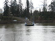
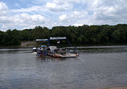

- Akers Ferry, across the Current RiverCurrent River (Missouri)The Current River forms in the southeastern portion of the Ozarks of Missouri and becomes a 7th order stream as it flows southeasterly out of the Ozarks into northeastern Arkansas where it becomes a tributary of the Black River, which is a tributary of the White River, a tributary of the...
near SalemSalem, Missouri-External links:* * Historic maps of Salem in the at the University of Missouri...
in MissouriMissouriMissouri is a US state located in the Midwestern United States, bordered by Iowa, Illinois, Kentucky, Tennessee, Arkansas, Oklahoma, Kansas and Nebraska. With a 2010 population of 5,988,927, Missouri is the 18th most populous state in the nation and the fifth most populous in the Midwest. It... - Avoca Island Ferry, across the intracoastal waterway to Avoca Island near Morgan CityMorgan City, LouisianaMorgan City is a city in St. Martin and St. Mary parishes in the U.S. state of Louisiana. The population was 12,404 at the 2010 census....
in LouisianaLouisianaLouisiana is a state located in the southern region of the United States of America. Its capital is Baton Rouge and largest city is New Orleans. Louisiana is the only state in the U.S. with political subdivisions termed parishes, which are local governments equivalent to counties... - Buena Vista Ferry, across the Willamette RiverWillamette RiverThe Willamette River is a major tributary of the Columbia River, accounting for 12 to 15 percent of the Columbia's flow. The Willamette's main stem is long, lying entirely in northwestern Oregon in the United States...
in OregonOregonOregon is a state in the Pacific Northwest region of the United States. It is located on the Pacific coast, with Washington to the north, California to the south, Nevada on the southeast and Idaho to the east. The Columbia and Snake rivers delineate much of Oregon's northern and eastern... - Canby Ferry, across the Willamette RiverWillamette RiverThe Willamette River is a major tributary of the Columbia River, accounting for 12 to 15 percent of the Columbia's flow. The Willamette's main stem is long, lying entirely in northwestern Oregon in the United States...
in OregonOregonOregon is a state in the Pacific Northwest region of the United States. It is located on the Pacific coast, with Washington to the north, California to the south, Nevada on the southeast and Idaho to the east. The Columbia and Snake rivers delineate much of Oregon's northern and eastern... - Los Ebanos FerryLos Ebanos FerryThe Los Ebanos Ferry, formally known as the Los Ebanos-Diaz Ordaz Ferry, is a hand-operated cable ferry that travels across the Rio Grande between Los Ebanos, Texas and Gustavo Díaz Ordaz, Tamaulipas. It is the last of its kind along the entire stretch of the Rio Grande...
, across the Rio GrandeRio GrandeThe Rio Grande is a river that flows from southwestern Colorado in the United States to the Gulf of Mexico. Along the way it forms part of the Mexico – United States border. Its length varies as its course changes...
between Los Ebanos, TexasLos Ebanos, TexasLos Ebanos is a census-designated place in Hidalgo County, Texas, United States. The population was 403 at the 2000 census. It is part of the McAllen–Edinburg–Mission Metropolitan Statistical Area...
and Gustavo Díaz Ordaz, TamaulipasGustavo Díaz Ordaz, TamaulipasGustavo Díaz Ordaz is a municipality located in the Mexican state of Tamaulipas.-Towns and villages:The largest localities are:-Adjacent municipalities and counties:* Reynosa Municipality - east... - Elwell FerryElwell FerryElwell Ferry is an inland cable ferry which has operated since 1905 on Elwell Ferry Road between NC Highway 53 and NC Highway 87, crossing the Cape Fear River and connecting the communities of Carvers Creek and Kelly in Bladen County, North Carolina....
, across the Cape Fear RiverCape Fear RiverThe Cape Fear River is a long blackwater river in east central North Carolina in the United States. It flows into the Atlantic Ocean near Cape Fear, from which it takes its name. The overall water quality of the river is continuously measured and monitored by and conducted by the , , and the...
in North CarolinaNorth CarolinaNorth Carolina is a state located in the southeastern United States. The state borders South Carolina and Georgia to the south, Tennessee to the west and Virginia to the north. North Carolina contains 100 counties. Its capital is Raleigh, and its largest city is Charlotte... - Fredericktown FerryFredericktown FerryThe Fredericktown Ferry is a cable driven ferry that operates on the Monongahela River in southwestern Pennsylvania about 30 miles south of Pittsburgh. The ferry consists of a 60-foot steel boat that can hold up to 6 vehicles at a time...
, across the Monongahela RiverMonongahela RiverThe Monongahela River is a river on the Allegheny Plateau in north-central West Virginia and southwestern Pennsylvania in the United States...
in southwestern PennsylvaniaPennsylvaniaThe Commonwealth of Pennsylvania is a U.S. state that is located in the Northeastern and Mid-Atlantic regions of the United States. The state borders Delaware and Maryland to the south, West Virginia to the southwest, Ohio to the west, New York and Ontario, Canada, to the north, and New Jersey to... - Hatton FerryHatton FerryHatton Ferry is a cable ferry located 5.5 miles west of Scottsville, Virginia on the James River. It is the last poled ferry in the United States. The ferry crosses the river upstream of Scottsville between Albemarle County and Buckingham County....
, across the James RiverJames River (Virginia)The James River is a river in the U.S. state of Virginia. It is long, extending to if one includes the Jackson River, the longer of its two source tributaries. The James River drains a catchment comprising . The watershed includes about 4% open water and an area with a population of 2.5 million...
in VirginiaVirginiaThe Commonwealth of Virginia , is a U.S. state on the Atlantic Coast of the Southern United States. Virginia is nicknamed the "Old Dominion" and sometimes the "Mother of Presidents" after the eight U.S. presidents born there... - Ironton FerryIronton FerryIronton Ferry is a four-car cable ferry that crosses a narrow point on the South Arm of Lake Charlevoix in the U.S. State of Michigan in the town Ironton. The Ferry connects Ironton, a small village about 5 miles from Charlevoix, Michigan, to Boyne City, Michigan. Ironton was a Pig Iron Factory...
, across an arm of Lake CharlevoixLake CharlevoixLake Charlevoix is a lake in Charlevoix County in the U.S. state of Michigan. It is the third largest lake in the state with a surface area of over 17,200 acres and 56 miles of shoreline...
in MichiganMichiganMichigan is a U.S. state located in the Great Lakes Region of the United States of America. The name Michigan is the French form of the Ojibwa word mishigamaa, meaning "large water" or "large lake".... - J-Mack Ferry, across an arm of the Sacramento RiverSacramento RiverThe Sacramento River is an important watercourse of Northern and Central California in the United States. The largest river in California, it rises on the eastern slopes of the Klamath Mountains, and after a journey south of over , empties into Suisun Bay, an arm of the San Francisco Bay, and...
in CaliforniaCaliforniaCalifornia is a state located on the West Coast of the United States. It is by far the most populous U.S. state, and the third-largest by land area... - Merrimac FerryMerrimac FerryThe Merrimac Ferry is a ferry that crosses the Wisconsin River between Columbia and Sauk Counties in Wisconsin. Its western point is located near the village of Merrimac on State Highway 113. The eastern point is located in Okee, Wisconsin....
, across the Wisconsin RiverWisconsin River-External links:* * * , Wisconsin Historical Society* * * *...
in WisconsinWisconsinWisconsin is a U.S. state located in the north-central United States and is part of the Midwest. It is bordered by Minnesota to the west, Iowa to the southwest, Illinois to the south, Lake Michigan to the east, Michigan to the northeast, and Lake Superior to the north. Wisconsin's capital is... - Merry Point Ferry, across the Corrotoman RiverCorrotoman RiverThe Corrotoman River is a small river on the northern banks of the Rappahannock River in Virginia, United States. The Corrotoman River is about 8 miles from the mouth of the Rappahannock River, which drains into the Chesapeake Bay. The Corrotoman River cuts into the Northern Neck; a region of...
in VirginiaVirginiaThe Commonwealth of Virginia , is a U.S. state on the Atlantic Coast of the Southern United States. Virginia is nicknamed the "Old Dominion" and sometimes the "Mother of Presidents" after the eight U.S. presidents born there... - Parker's FerryParker's FerryParker's Ferry is a cable ferry located on the Meherrin River in Hertford County, North Carolina. The ferry is operated by a contractor for the North Carolina Department of Transportation....
, across the Meherrin RiverMeherrin RiverThe Meherrin River is a long river in the U.S. states of Virginia and North Carolina. It begins in central Virginia, about northwest of Emporia, and flows roughly east-southeast into North Carolina, where it joins the larger Chowan River....
in North Carolina - Princeton Ferry, across the Sacramento River in California
- Sans Souci FerrySans Souci FerryThe Sans Souci Ferry is a cable ferry located on the Cashie River in Bertie County, North Carolina. The ferry is operated by the North Carolina Department of Transportation....
, across the Cashie River in North Carolina - Saugatuck Ferry, across the Kalamazoo RiverKalamazoo RiverThe Kalamazoo River is a river in the U.S. state of Michigan. The river is long from the junction of its North and South branches to its mouth at Lake Michigan, with a total length extending to when one includes the South Branch...
in Michigan - Sunnybank Ferry, across the Little Wicomico RiverLittle Wicomico RiverThe Little Wicomico River is a river in the United States state of Virginia. The river, mostly tidal, lows into Chesapeake Bay at the junction of the south shore of the Potomac River, which is also the Maryland-Virginia boundary, with Chesapeake Bay....
in Virginia - Sycamore Island Ferry, across the Potomac RiverPotomac RiverThe Potomac River flows into the Chesapeake Bay, located along the mid-Atlantic coast of the United States. The river is approximately long, with a drainage area of about 14,700 square miles...
in MarylandMarylandMaryland is a U.S. state located in the Mid Atlantic region of the United States, bordering Virginia, West Virginia, and the District of Columbia to its south and west; Pennsylvania to its north; and Delaware to its east... - Ticonderoga Ferry, across Lake ChamplainLake ChamplainLake Champlain is a natural, freshwater lake in North America, located mainly within the borders of the United States but partially situated across the Canada—United States border in the Canadian province of Quebec.The New York portion of the Champlain Valley includes the eastern portions of...
between Ticonderoga, New YorkNew YorkNew York is a state in the Northeastern region of the United States. It is the nation's third most populous state. New York is bordered by New Jersey and Pennsylvania to the south, and by Connecticut, Massachusetts and Vermont to the east...
and ShorehamShoreham, VermontShoreham is a town in Addison County, Vermont, United States. The population was 1,222 at the 2000 census.-Geography:According to the United States Census Bureau, the town has a total area of 46.3 square miles , of which 43.5 square miles is land and 2.8 square miles is...
, VermontVermontVermont is a state in the New England region of the northeastern United States of America. The state ranks 43rd in land area, , and 45th in total area. Its population according to the 2010 census, 630,337, is the second smallest in the country, larger only than Wyoming. It is the only New England... - Upper Ferry, across the Wicomico RiverWicomico River (Maryland eastern shore)The Wicomico River is a tributary of the Chesapeake Bay on the eastern shore of Maryland. It drains an area of low marshlands and farming country in the middle Delmarva Peninsula. The name "Wicomico" derives from the words wicko mekee, meaning "a place where houses are built," apparently...
in Maryland - Valley View FerryValley View FerryThe Valley View Ferry provides passage over the Kentucky River in rural central Kentucky. Located on Kentucky Route 169, it helps connect auto traffic between the county seats of Richmond in Madison County and Nicholasville in Jessamine County. The ferry was founded in 1780, predating Kentucky's...
, across the Kentucky RiverKentucky RiverThe Kentucky River is a tributary of the Ohio River, long, in the U.S. state of Kentucky. The river and its tributaries drain much of the central region of the state, with its upper course passing through the coal-mining regions of the Cumberland Mountains, and its lower course passing through the...
in KentuckyKentuckyThe Commonwealth of Kentucky is a state located in the East Central United States of America. As classified by the United States Census Bureau, Kentucky is a Southern state, more specifically in the East South Central region. Kentucky is one of four U.S. states constituted as a commonwealth... - Wheatland FerryWheatland FerryThe Wheatland Ferry is a cable ferry that connects Marion County and Yamhill County across the Willamette River in the U.S. state of Oregon. The ferry travels approximately 580 feet across the river, depending on the height of the river, and is powered by two electric motors connected to an...
, across the Willamette River in Oregon - White's FerryWhite's FerryWhite's Ferry is a cable ferry service operating across the Potomac River. It is located six miles west of Poolesville, Maryland, and north of Leesburg, Virginia. It is the only ferry still operating on the Potomac River. The General Jubal A...
, across the Potomac River in Maryland - Whitehaven Ferry, across the Wicomico River at WhitehavenWhitehaven, MarylandWhitehaven is an unincorporated community in Wicomico County, Maryland, United States.Whitehaven is home to one of the few remaining public ferries in Maryland, and was once a thriving settlement which included stores, a shipyard, and the Whitehaven Hotel. It is the location of the Whitehaven...
, Maryland - Woodland FerryWoodland FerryThe Woodland Ferry is a cable ferry located in western Sussex County, Delaware, spanning the Nanticoke River, west of the city of Seaford. The ferry is currently operated by the Delaware Department of Transportation, and operates year-round...
, across the Nanticoke RiverNanticoke RiverThe Nanticoke River is a major tributary of the Chesapeake Bay on the Delmarva Peninsula. It rises in southern Kent County, Delaware, flows through Sussex County, Delaware, and forms the boundary between Dorchester County, Maryland and Wicomico County, Maryland. The river course proceeds southwest...
in DelawareDelawareDelaware is a U.S. state located on the Atlantic Coast in the Mid-Atlantic region of the United States. It is bordered to the south and west by Maryland, and to the north by Pennsylvania...
Zambia
- Chambeshi Ferry, across the Chambeshi RiverChambeshi RiverThe Chambeshi River of northeastern Zambia is the most remote headstream of the Congo River and therefore considered its source...
near Mbesuma - Kabompo FerryKabompo FerryThe Kabompo Ferry is a vehicle pontoon ferry with a 25-tonne capacity on the Kabompo River dividing the Western and North-Western Provinces of Zambia. It is a manually-powered cable ferry, propelled by pulling on the steel cables which anchor it to each bank of the 100 m wide river...
, across the Kabompo RiverKabompo RiverThe Kabompo River is one of the main tributaries of the upper Zambezi River river. It flows entirely in Zambia, rising to the east of the source of the Zambezi, in North-Western Province along the watershed between the Zambezi and Congo river basins which also forms the border between Zambia and DR...
80 km south-east of Kabompo - Kafue Ferry, across the Kafue RiverKafue RiverThe Kafue River sustains one of the world's great wildlife environments. It is a major tributary of the Zambezi, and of Zambia's principal rivers, it is the most central and the most urban, and the longest and largest lying wholly within Zambia....
4.5 km west of the ZambeziZambeziThe Zambezi is the fourth-longest river in Africa, and the largest flowing into the Indian Ocean from Africa. The area of its basin is , slightly less than half that of the Nile...
See also
- Aerial tramwayAerial tramwayAn aerial tramway , cable car , ropeway or aerial tram is a type of aerial lift which uses one or two stationary ropes for support while a third moving rope provides propulsion...
- Cable carCable car (railway)A cable car or cable railway is a mass transit system using rail cars that are hauled by a continuously moving cable running at a constant speed. Individual cars stop and start by releasing and gripping this cable as required...
- FerryFerryA ferry is a form of transportation, usually a boat, but sometimes a ship, used to carry primarily passengers, and sometimes vehicles and cargo as well, across a body of water. Most ferries operate on regular, frequent, return services...
- FunicularFunicularA funicular, also known as an inclined plane or cliff railway, is a cable railway in which a cable attached to a pair of tram-like vehicles on rails moves them up and down a steep slope; the ascending and descending vehicles counterbalance each other.-Operation:The basic principle of funicular...
- Pontoon (boat)Pontoon (boat)A pontoon is a flotation device with buoyancy sufficient to float itself as well as a heavy load. A pontoon boat is a flattish boat that relies on pontoons to float. Pontoons may be used on boats, rafts, barges, docks, floatplanes or seaplanes. Pontoons may support a platform, creating a raft. A...
- Punt (boat)Punt (boat)A punt is a flat-bottomed boat with a square-cut bow, designed for use in small rivers or other shallow water. Punting refers to boating in a punt. The punter generally propels the punt by pushing against the river bed with a pole...
- Reaction ferryReaction ferryA reaction ferry is a cable ferry that uses the reaction of the current of a river against a fixed tether to propel the vessel across the river...
External links
- Twyford chain ferry on the River TrentRiver TrentThe River Trent is one of the major rivers of England. Its source is in Staffordshire on the southern edge of Biddulph Moor. It flows through the Midlands until it joins the River Ouse at Trent Falls to form the Humber Estuary, which empties into the North Sea below Hull and Immingham.The Trent...
,UK, 1899 - Cable ferries operating in New Brunswick, Canada