
Port Macquarie, New South Wales
Encyclopedia

New South Wales
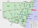
New South Wales is a state of :Australia, located in the east of the country. It is bordered by Queensland, Victoria and South Australia to the north, south and west respectively. To the east, the state is bordered by the Tasman Sea, which forms part of the Pacific Ocean. New South Wales...
, Australia
Australia
Australia , officially the Commonwealth of Australia, is a country in the Southern Hemisphere comprising the mainland of the Australian continent, the island of Tasmania, and numerous smaller islands in the Indian and Pacific Oceans. It is the world's sixth-largest country by total area...
, located about 390 km (242 mi) north of Sydney
Sydney
Sydney is the most populous city in Australia and the state capital of New South Wales. Sydney is located on Australia's south-east coast of the Tasman Sea. As of June 2010, the greater metropolitan area had an approximate population of 4.6 million people...
, and 570 km (354 mi) south of Brisbane. The city is located on the coast, at the mouth of the Hastings River
Hastings River
The Hastings River is a large river on the Mid North Coast of the Australian state of New South Wales that empties into the Tasman Sea, a branch of the South Pacific Ocean, at Port Macquarie....
, and has an estimated population of 44,313.
History
The site of Port Macquarie was first visited by Europeans in 1818 when John OxleyJohn Oxley
John Joseph William Molesworth Oxley was an explorer and surveyor of Australia in the early period of English colonisation.October 1802 he was engaged in coastal survey work including an expedition to Western Port in 1804-05...
reached the Pacific Ocean
Pacific Ocean
The Pacific Ocean is the largest of the Earth's oceanic divisions. It extends from the Arctic in the north to the Southern Ocean in the south, bounded by Asia and Australia in the west, and the Americas in the east.At 165.2 million square kilometres in area, this largest division of the World...
from the interior, after his journey to explore inland New South Wales. He named the location after the Governor of New South Wales
Governors of New South Wales
The Governor of New South Wales is the state viceregal representative of the Australian monarch, Queen Elizabeth II, who is equally shared with 15 other sovereign nations in a form of personal union, as well as with the eleven other jurisdictions of Australia, and resides predominantly in her...
, Lachlan Macquarie
Lachlan Macquarie
Major-General Lachlan Macquarie CB , was a British military officer and colonial administrator. He served as the last autocratic Governor of New South Wales, Australia from 1810 to 1821 and had a leading role in the social, economic and architectural development of the colony...
.
Oxley noted that 'the port abounds with fish, the sharks were larger and more numerous than I have ever before observed. The forest hills and rising grounds abounded with large kangaroos and the marshes afford shelter and support to innumerable wild fowl. Independent of the Hastings River, the area is generally well watered, there is a fine spring at the very entrance to the Port'.
In 1821, Port Macquarie was founded as the first penal settlement, replacing Newcastle
Newcastle, New South Wales
The Newcastle metropolitan area is the second most populated area in the Australian state of New South Wales and includes most of the Newcastle and Lake Macquarie Local Government Areas...
as the destination for convicts that had committed secondary crimes in New South Wales
New South Wales
New South Wales is a state of :Australia, located in the east of the country. It is bordered by Queensland, Victoria and South Australia to the north, south and west respectively. To the east, the state is bordered by the Tasman Sea, which forms part of the Pacific Ocean. New South Wales...
. Newcastle, which had fulfilled this role for the previous two decades, had lost the features required for a place for dumping irredeemable criminals, that being isolation, which was lost as the Hunter Valley
Hunter Valley
The Hunter Region, more commonly known as the Hunter Valley, is a region of New South Wales, Australia, extending from approximately to north of Sydney with an approximate population of 645,395 people. Most of the population of the Hunter Region lives within of the coast, with 55% of the entire...
was opened up to farmers, and large amounts of hard labour, which had diminishing as the cedar in the area ran out and the settlement grew in size. Port Macquarie, however, with its thick bush, tough terrain and local aborigines
Australian Aborigines
Australian Aborigines , also called Aboriginal Australians, from the latin ab originem , are people who are indigenous to most of the Australian continentthat is, to mainland Australia and the island of Tasmania...
that were keen to return escaping prisoners in return for tobacco and blankets, provided large amounts of both isolation and hard labour to keep the criminals in control. Under its first commandant, Francis Allman, who was fond of the flogging, the settlement became hell, where the convicts had limited liberties, especially in regard to being in possession of letters and writing papers, which could get a convict up to 100 lashes.
Due to the lack of liberties of the settlement, Ralph Darling
Ralph Darling
General Sir Ralph Darling, GCH was a British colonial Governor and Governor of New South Wales from 1825 to 1831.-Early career:...
, governor of New South Wales, quickly sent many 'specials' or literate convicts with a decent education who had voiced negative views about him. Later on in the settlements history, in the 1830s, disabled convicts started to arrive. One-armed men would be grouped together and required to break stones, men with wooden legs would become delivery men, and the blind would often be given tasks during the night which they performed more skilfully than those with sight.
In 1823 the first sugar cane to be cultivated in Australia was planted there. The region was first opened to settlers in 1830 and later on in the decade the penal settlement was closed in favour of a new penal settlement at Moreton Bay
Brisbane
Brisbane is the capital and most populous city in the Australian state of Queensland and the third most populous city in Australia. Brisbane's metropolitan area has a population of over 2 million, and the South East Queensland urban conurbation, centred around Brisbane, encompasses a population of...
. Settlers quickly took advantage of the area's good pastoral land, timber resources and fisheries.
St Thomas’ Anglican Church is a Georgian building designed by Lieutenant T Owen and was built by convicts under military supervision during 1824-1828. This church is among the oldest in Australia and one of the few remaining convict built churches. Inside there are red cedar box pews that were peculiar to that period in church architecture. The Walker Pipe Organ is the only one of its type in the southern hemisphere
Southern Hemisphere
The Southern Hemisphere is the part of Earth that lies south of the equator. The word hemisphere literally means 'half ball' or "half sphere"...
. The castellated tower permits excellent views of the coastline, town and river. This church is now classified by the National Trust of Australia
National Trust of Australia
The Australian Council of National Trusts is the peak body for community-based, non-government organisations committed to promoting and conserving Australia's indigenous, natural and historic heritage....
(NSW) and it is also registered on the National Estate.
In 1840 the “Wool Road” from the Northern Tablelands was under construction to enable wool
Wool
Wool is the textile fiber obtained from sheep and certain other animals, including cashmere from goats, mohair from goats, qiviut from muskoxen, vicuña, alpaca, camel from animals in the camel family, and angora from rabbits....
and other produce to be shipped from the port. Port Macquarie was declared a municipality in 1887, but the town never progressed as a port due to presence of a notorious coastal bar across the mouth of the river.
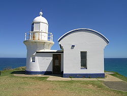
Over 20 shipwrecks occurred in the Tacking Point area before a lighthouse was designed by James Barnet
James Barnet
James Johnstone Barnet was the Colonial Architect for New South Wales from 1862 - 1890.-Life and career:Barnet was born at Almericlose, Arbroath, Scotland. The son of a builder, he was educated at the local high school...
and erected there in 1879 by Shepard and Mortley. Tacking Point Lighthouse
Tacking Point Lighthouse
Tacking Point Lighthouse is Australia's third oldest lighthouse. It was built on a rocky headland about 8 kilometres south of Port Macquarie in 1879 by Shepard and Mortley, to a design by the New South Wales government's architect of the time, James Barnet...
is classified by the National Trust of Australia (NSW).
Population
In the 2006 Census the wider area of the Hastings Valley had a total population of 68,429 up 9.5% from the 2001 Census. Port Macquarie is now the fastest growing place in New South Wales. The town is expected to grow from an estimated 43,655 people in 2009 to 58,888 in 2027.General
Port Macquarie is a retirement destination, known for its extensive beaches and waterways. The town is also known for its koalaKoala
The koala is an arboreal herbivorous marsupial native to Australia, and the only extant representative of the family Phascolarctidae....
population, being the home to the Billabong Koala Park
Billabong Koala Park
Billabong Koala Park is a wildlife park and koala breeding center located in Port Macquarie, New South Wales, Australia. It was opened in 1989, and features a wide variety of Australian and exotic animals. It is known world wide as a breeding centre for koalas....
, and the Koala Preservation Society's Koala Hospital, caring for koalas injured through bushfire, dog attacks and collisions with vehicles.
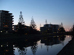
In recent times, real estate developments have led to debates with residents, in particular the Rydges Hotel (formerly Four Points by Sheraton) built opposite the Town Green. The Post Office on the Town Green was demolished to make way for a new apartment block, a development that saw the controversial removal of several large fig trees and subsequent debate in the community about the value of public space.
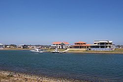
The residential suburbs stretch to Lighthouse Beach in the south, Thrumster to the west and to the north shore, on the north bank of the river. Settlement Point has a new canal development, being one of the most recent real estate developments in the town. More recently, July 2010, Sovereign Hills, has begun development in the west. At present it includes a new school, St Joseph's Regional College, and shortly there be will shopping facilities and residential areas.
To get a first hand impression of life in Port Macquarie, there are plenty of historical documents available for viewing at the Port Macquarie Historical Society.
Transit Hill
Transit Hill is an area in the south of Port Macquarie that provides communication and transport links to the rest of the Port Macquarie Area. The peak of Transit Hill is occupied by telecommunication towers, particularly Optus and Telstra towers.Transit Hill also features two of Port Macquarie's main arterial roads which provide a direct link between Lighthouse Beach and Port Macquarie CBD. The main intersection of Pacific and Kennedy Drive is situated midway up Transit Hill.
Transit Hill is a mid to high socio-economic community, with houses on Orr Street fetching high sales prices due to its ocean and city views. Transit Hill borders Lighthouse Beach, Dahlsford, Shelley Beach and Waniora.
Beaches
Beaches include (in order from north to south): North Shore, Town Beach, Oxley Beach, Rocky Beach, Flynns Beach, Nobbys Beach, Shelly Beach, Miners Beach and Lighthouse Beach. Only Town, Flynns and Lighthouse Beaches are manned by Surf Life Saving ClubSurf Life Saving Club
Surf Life Saving Clubs are volunteer institutions at Australia's beaches. The clubs conduct surf lifesaving services on weekends and public holidays and host many beach sport activities, such as Nippers, surf carnivals and other competitions...
s. Lighthouse beach is only patrolled at the northern end. Dogs can be walked off-leash at Lighthouse Beach, excluding sections at the northern end.
Climate
Port Macquarie has a humid subtropical climate.
Public schools
- Port Macquarie Public School
- Westport Public School
- Hastings Public School
- Tacking Point Public School
Catholic schools
- St. Joseph's Primary School
- St. Peter's Primary School
- St. Agnes' Primary School
Other private schools
- St. Columba Anglican School
- Port Macquarie Adventist School
- Heritage Christian School
Private schools
- St. Columba Anglican School
- Heritage Christian School
- St. Joseph's Regional College
- St. Paul's High School
- Newman Senior Technical College (Year 11 & 12)
- Mackillop Senior College (Year 11 & 12)
Tertiary educational facilities
There is also a TAFE campus for further qualifications. Courses are also offered by the University of NewcastleUniversity of Newcastle, Australia
The University of Newcastle is an Australian public university that was established in 1965. The University's main and largest campus is located in Callaghan, a suburb of Newcastle in New South Wales...
through the TAFE campus.
Transport links
Port Macquarie is linked by daily air services to Sydney.Port Macquarie is linked by a 6 Day Shuttle Service called Holiday Coast Connections. The area they service is Port Macquarie, Lake Cathie,Bonny Hills,Laureiton, Kew, Taree, Forster, Bulahdelah, Newcastle Airport, Newcastle Railway, John Hunter Hospital, Mater Hospital and Newcastle Uni.
Road access is via the Pacific
Pacific Highway (Australia)
The Pacific Highway is a major transport route along part of the east coast of Australia and is part of Australia's national route 1.It is 960 km long and links Sydney, the capital of New South Wales, to Brisbane, the capital of Queensland, along the coast, via Gosford, Newcastle, Taree, Port...
and Oxley
Oxley Highway
The Oxley Highway is a rural highway in New South Wales, Australia. It starts at Nevertire where it joins the Mitchell Highway. It links Warren, Gilgandra, Coonabarabran, Gunnedah, Carroll, Tamworth, Bendemeer, Walcha, Yarrowitch, Ellenborough, Long Flat, Wauchope and ends at Port Macquarie on the...
Highways. The Pacific Highway lies between Port Macquarie and Wauchope, and is the main road for tourists travelling from coastal areas. Improvements to the Oxley and Pacific Highway has seen steady improvements in travel times between Sydney and the mid-north coast region from 6 hours to just 4 hours (from Wahroonga to the Oxley Highway interchange);
The four proposed or in-construction road projects that are underway:
- Karuah to Bulahdelah section 2 and 3 - Under construction (Karuah to Bulahdelah section 1 - Completed December 2006).
- BulahdelahBulahdelahBulahdelah is a locality in the Hunter/Mid North Coast region of New South Wales, Australia in the Great Lakes Council Local Government Area. The main population centre, where 69% of the area's population lives, is the town of Bulahdelah.-Geography:...
Bypass - Early works commenced in November 2007. The Bulahdelah bypass/upgrade will fill the only missing link between Hexham and Port Macquarie once the Karuah to Bulahdelah section(s) 2 and 3 and the Coopernook to Herons Creek upgrades are open in 2010. - Coopernook to Herons Creek - Under construction.
- The Oxley Highway upgrade, from a 2 lane undivided road to a 4-lane divided carriageway, from Wrights Road to the Pacific Highway, stage 1 - Pre-construction.
These four projects are all from the AusLink
AusLink
AusLink was an Australian Government land transport funding program, established in June 2004 and administered by the Department of Transport and Regional Services. In 2009 it was replaced with the Nation Building Program under the Nation Building Program Act 2009...
funding on a 50/50 "joint basis" from the Commonwealth and the state of NSW (50% from Commonwealth Government and the other 50% from the NSW Government.
There is no railway station in Port Macquarie. The closet station providing passenger service is located in Wauchope
Wauchope, New South Wales
-People from Wauchope:* Iva Davies - Musician, Icehouse* Alison Langdon - Channel Nine News Reader - Today Show* Phil Jamieson - Musician, Grinspoon* Andrew Stoner - NSW National Party of Australia leader, Member for Oxley...
(19 kilometres (11.8 mi) inland) on the North Coast Railway Line
North Coast railway line, New South Wales
The North Coast Line is the primary rail route in the Mid North Coast and Northern Rivers regions of New South Wales, and forms a major part of the Sydney-Brisbane rail corridor....
. A bus transfer service is available from Port Macqaurie to Wauchope station.
Port Macquarie Airport
Port Macquarie Airport
Port Macquarie Airport is an airport in Port Macquarie, New South Wales, Australia. The airport is 5 km from the city center and is owned and managed by the Port Macquarie-Hastings Council...
has regular flights to Sydney with QantasLink
QantasLink
QantasLink is a regional brand of Australian airline Qantas and is an affiliate member of the Oneworld airline alliance. It is a major competitor to Regional Express Airlines, Virgin Australia and Skywest Airlines. As of September 2010 QantasLink provides 1900 flights each week to 54 domestic and...
(5 times daily) and Virgin Australia (twice daily), and also to Lord Howe Island
Lord Howe Island
Lord Howe Island is an irregularly crescent-shaped volcanic remnant in the Tasman Sea between Australia and New Zealand, directly east of mainland Port Macquarie, and about from Norfolk Island. The island is about 11 km long and between 2.8 km and 0.6 km wide with an area of...
with QantasLink
QantasLink
QantasLink is a regional brand of Australian airline Qantas and is an affiliate member of the Oneworld airline alliance. It is a major competitor to Regional Express Airlines, Virgin Australia and Skywest Airlines. As of September 2010 QantasLink provides 1900 flights each week to 54 domestic and...
.
Annual events
- Festival of the SunFestival of the SunFestival of the Sun is an annual outdoor music festival held in December at the Sundowner Breakwall Tourist Park[1], Port Macquarie, New South Wales, Australia...
(December) - Sundowner BREAM Classic (November)
- Pacific Coast Slam (January)
Ironman
See also
- Lake Cathie, New South WalesLake Cathie, New South WalesLake Cathie is a town in New South Wales, Australia about 15 minutes drive south of Port Macquarie and has a permanent population of 2,000.The town is a popular holiday destination on the Mid North Coast because of its tranquil location which hosts the lake, lagoon and beaches...
- Laurieton, New South WalesLaurieton, New South WalesLaurieton is a coastal town on the Mid North Coast of the Australian state of New South Wales. Laurieton is the largest town in the Camden Haven district. Laurieton is 365 km north of Sydney and 42 km south of Port Macquarie...
- Macquarie CountyMacquarie County, New South WalesMacquarie County is one of the 141 Cadastral divisions of New South Wales, Australia. It is bordered to the north by the Apsley River, and to the south by the Manning River...
External links
- Port Macquarie-Hastings Council
- Port Macquarie Tourist Information
- Port Macquarie Koala Hospital
- Festival of the Sun
- Port Macquarie Hastings Municipal Band
- Greater Port Macquarie Focus Magazine
- St Columba Anglican School
- Greater Port Macquarie Discover Magazine
- Port Macquarie Holiday Guide
- Port Macquarie.info
- Port News