

Kennebecasis River
Encyclopedia
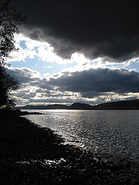
The Kennebecasis River (icon ) is a tributary of the Saint John River
in southern New Brunswick
, Canada
. The name Kennebecasis is thought to be derived from the Mi'kmaq "Kenepekachiachk", meaning "little long bay place." It runs for approximately 95 kilometres, draining an area in the Caledonia Highlands, an extension of the Appalachian Mountains
, inland from the Bay of Fundy
.
, near the rural community of Goshen. It runs southwest through the community of Penobsquis
; several tributaries join the river in the town of Sussex
several kilometres further west.
Between Sussex and the river's junction with the Saint John River at Millidgeville
(part of Saint John
), the Kennebecasis River runs through a well-defined river valley which has become one of the primary land transportation routes in the southern part of the province, hosting the Route 1
expressway
and the Canadian National Railway
line to the Port of Saint John
.
The upper two thirds of the Kennebecasis River passes through pastoral rural countryside consisting of Acadian mixed forest and various agricultural areas, notably dairy
farms around Sussex. Southwest of Sussex, the river becomes increasingly larger as it passes the communities of Norton
and Hampton
, before it empties into a delta
-like area called Hampton Marsh. West of Hampton, the Kennebecasis flows in a broad fjord
-like glacial valley which defines the southern side of the Kingston Peninsula. At its junction with the Saint John River, the Kennebecasis River helps to form Grand Bay.
Several large islands can be found in the river, such as Kennebecasis Island
just off-shore from Summerville on the Kingston Peninsula, and uninhabited (with the exception of a few summer cottages) Long Island, located near Rothesay
.
 The communities of Nauwigewauk
, Quispamsis
and Rothesay
become increasingly urban as the river approaches its junction with the Saint John River. The lower Kennebecasis River valley is largely a suburban/exurban region for Saint John
. The area is outside the summer 'fog
belt' for the Bay of Fundy
and enjoys more sunshine year-round than Saint John. It is also substantially colder in winter than the Bay of Fundy-climate controlled city proper.
"The Valley" or "KV", as the lower Kennebecasis River valley is called by locals, has experienced dramatic population growth over the past several decades, largely owing to the development of Route 1 through the area in the 1960s. Once a minor dormitory suburb of the Saint John area, the towns of Rothesay and Quispamsis constitute a moderately-sized population centre with some commercial development. Saint John, by contrast, has suffered from an erosion of its tax and commercial bases as population and businesses have migrated away from the urban core.
The Kennebecasis effectively isolates the Kingston Peninsula
from suburban sprawl. It is crossed by two ferry services, the Gondola Point Ferry
that connects Gondola Point
to Reeds Point, and the Summerville to Millidgeville Ferry
that connects Millidgeville
to Summerville. A third ferry service, the Kennebecasis Island Ferry
connects Summerville to Kennebecasis Island
. Several controversial proposals have been made in recent decades to build a highway bridge over the Kennebecasis River to the Kingston Peninsula however this has been rejected by numerous provincial governments citing financial pressures as well as the likelihood of suburban sprawl occurring in this farming area as a result.
The Kennebecasis River valley communities have rich histories; many were settled by Loyalists in the 1780s and 1790s who traveled upriver from Saint John to land grants offered by the British government. They became more prominent during the late 1800s following construction of the European and North American Railway
through the area, which allowed for easier travel between Saint John and Moncton. Over the ensuing decades, the lower Kennebecasis River valley became a summer vacation destination for wealthy Maritimers, Americans and central Canadians. It is also a popular cruising
destination for recreational boating as a result of its connection with the navigable portions of the Saint John River.
45°19′0"N 66°8′0"W
Saint John River
The Saint John River is a river, approximately long, located principally in the Canadian province of New Brunswick but also in, and arising from the province of Quebec and the U.S. state of Maine. It forms part of the Canada – United States border in two different places along its length...
in southern New Brunswick
New Brunswick
New Brunswick is one of Canada's three Maritime provinces and is the only province in the federation that is constitutionally bilingual . The provincial capital is Fredericton and Saint John is the most populous city. Greater Moncton is the largest Census Metropolitan Area...
, Canada
Canada
Canada is a North American country consisting of ten provinces and three territories. Located in the northern part of the continent, it extends from the Atlantic Ocean in the east to the Pacific Ocean in the west, and northward into the Arctic Ocean...
. The name Kennebecasis is thought to be derived from the Mi'kmaq "Kenepekachiachk", meaning "little long bay place." It runs for approximately 95 kilometres, draining an area in the Caledonia Highlands, an extension of the Appalachian Mountains
Appalachian Mountains
The Appalachian Mountains #Whether the stressed vowel is or ,#Whether the "ch" is pronounced as a fricative or an affricate , and#Whether the final vowel is the monophthong or the diphthong .), often called the Appalachians, are a system of mountains in eastern North America. The Appalachians...
, inland from the Bay of Fundy
Bay of Fundy
The Bay of Fundy is a bay on the Atlantic coast of North America, on the northeast end of the Gulf of Maine between the Canadian provinces of New Brunswick and Nova Scotia, with a small portion touching the U.S. state of Maine...
.
Description
The river's source is in the foothills of Albert CountyAlbert County, New Brunswick
Albert County is located in southeastern New Brunswick, Canada on the Chignecto Bay of the Bay of Fundy. Prior to the abolition of county government in 1967, the county seat was Hopewell Cape...
, near the rural community of Goshen. It runs southwest through the community of Penobsquis
Penobsquis, New Brunswick
Penobsquis is a Canadian village in New Brunswick.It is located east of Sussex in the Kennebecasis River valley. The area has many dairy farms....
; several tributaries join the river in the town of Sussex
Sussex, New Brunswick
Sussex is a Canadian town in Kings County, New Brunswick.Sussex straddles the Kennebecasis River, 70 km northeast of Saint John, and is a major dairy products producer in the province...
several kilometres further west.
Between Sussex and the river's junction with the Saint John River at Millidgeville
Millidgeville, New Brunswick
Millidgeville is a Canadian neighbourhood in the city of Saint John, New Brunswick.Millidgeville is situated on the northern edge of the city, on Brothers Cove off the Kennebecasis River at the point where that westerly flowing river meets the southerly flowing St. John River...
(part of Saint John
Saint John, New Brunswick
City of Saint John , or commonly Saint John, is the largest city in the province of New Brunswick, and the first incorporated city in Canada. The city is situated along the north shore of the Bay of Fundy at the mouth of the Saint John River. In 2006 the city proper had a population of 74,043...
), the Kennebecasis River runs through a well-defined river valley which has become one of the primary land transportation routes in the southern part of the province, hosting the Route 1
New Brunswick Route 1
Route 1 is an important highway in the southern part of the Canadian province of New Brunswick. It begins in the west from the Canada-United States border at St. Stephen, and runs east for to Route 2 at River Glade....
expressway
Limited-access road
A limited-access road known by various terms worldwide, including limited-access highway, dual-carriageway and expressway, is a highway or arterial road for high-speed traffic which has many or most characteristics of a controlled-access highway , including limited or no access to adjacent...
and the Canadian National Railway
Canadian National Railway
The Canadian National Railway Company is a Canadian Class I railway headquartered in Montreal, Quebec. CN's slogan is "North America's Railroad"....
line to the Port of Saint John
Port of Saint John
The Port of Saint John is a port complex that occupies of land along of waterfront. The port is located at the mouth of the Saint John River in Saint John, New Brunswick, with facilities on both sides of the river. The Port of Saint John is noted for its extreme tidal range and river currents...
.
The upper two thirds of the Kennebecasis River passes through pastoral rural countryside consisting of Acadian mixed forest and various agricultural areas, notably dairy
Dairy
A dairy is a business enterprise established for the harvesting of animal milk—mostly from cows or goats, but also from buffalo, sheep, horses or camels —for human consumption. A dairy is typically located on a dedicated dairy farm or section of a multi-purpose farm that is concerned...
farms around Sussex. Southwest of Sussex, the river becomes increasingly larger as it passes the communities of Norton
Norton, New Brunswick
Norton is a Canadian village in Kings County, New Brunswick.It is situated on the Kennebecasis River 55 kilometres northeast of Saint John...
and Hampton
Hampton, New Brunswick
Hampton is a Canadian town in Kings County, New Brunswick.Located on the Kennebecasis River 30 kilometres northeast of Saint John, Hampton is the shire town of Kings County...
, before it empties into a delta
River delta
A delta is a landform that is formed at the mouth of a river where that river flows into an ocean, sea, estuary, lake, reservoir, flat arid area, or another river. Deltas are formed from the deposition of the sediment carried by the river as the flow leaves the mouth of the river...
-like area called Hampton Marsh. West of Hampton, the Kennebecasis flows in a broad fjord
Fjord
Geologically, a fjord is a long, narrow inlet with steep sides or cliffs, created in a valley carved by glacial activity.-Formation:A fjord is formed when a glacier cuts a U-shaped valley by abrasion of the surrounding bedrock. Glacial melting is accompanied by rebound of Earth's crust as the ice...
-like glacial valley which defines the southern side of the Kingston Peninsula. At its junction with the Saint John River, the Kennebecasis River helps to form Grand Bay.
Several large islands can be found in the river, such as Kennebecasis Island
Kennebecasis Island
Kennebecasis Island is a small Canadian island located in the Province of New Brunswick at the confluence of the St. John River and Kennebecasis River....
just off-shore from Summerville on the Kingston Peninsula, and uninhabited (with the exception of a few summer cottages) Long Island, located near Rothesay
Rothesay, New Brunswick
Rothesay is a Canadian town located in Kings County, New Brunswick. It is a bedroom community of Saint John along the Kennebecasis River.Located along the lower Kennebecasis River valley, Rothesay borders the city of Saint John to the southwest, and the neighbouring town of Quispamsis to the...
.
Lower Kennebecasis River valley
Nauwigewauk, New Brunswick
Nauwigewauk is a community in the Canadian province of New Brunswick....
, Quispamsis
Quispamsis, New Brunswick
Quispamsis is a Canadian town located in Kings County, New Brunswick. It is located 20 kilometres northeast of Saint John, in the lower Kennebecasis River valley.The name is traditionally pronounced with a weak stress on either the first or last syllable....
and Rothesay
Rothesay, New Brunswick
Rothesay is a Canadian town located in Kings County, New Brunswick. It is a bedroom community of Saint John along the Kennebecasis River.Located along the lower Kennebecasis River valley, Rothesay borders the city of Saint John to the southwest, and the neighbouring town of Quispamsis to the...
become increasingly urban as the river approaches its junction with the Saint John River. The lower Kennebecasis River valley is largely a suburban/exurban region for Saint John
Saint John, New Brunswick
City of Saint John , or commonly Saint John, is the largest city in the province of New Brunswick, and the first incorporated city in Canada. The city is situated along the north shore of the Bay of Fundy at the mouth of the Saint John River. In 2006 the city proper had a population of 74,043...
. The area is outside the summer 'fog
Fog
Fog is a collection of water droplets or ice crystals suspended in the air at or near the Earth's surface. While fog is a type of stratus cloud, the term "fog" is typically distinguished from the more generic term "cloud" in that fog is low-lying, and the moisture in the fog is often generated...
belt' for the Bay of Fundy
Bay of Fundy
The Bay of Fundy is a bay on the Atlantic coast of North America, on the northeast end of the Gulf of Maine between the Canadian provinces of New Brunswick and Nova Scotia, with a small portion touching the U.S. state of Maine...
and enjoys more sunshine year-round than Saint John. It is also substantially colder in winter than the Bay of Fundy-climate controlled city proper.
"The Valley" or "KV", as the lower Kennebecasis River valley is called by locals, has experienced dramatic population growth over the past several decades, largely owing to the development of Route 1 through the area in the 1960s. Once a minor dormitory suburb of the Saint John area, the towns of Rothesay and Quispamsis constitute a moderately-sized population centre with some commercial development. Saint John, by contrast, has suffered from an erosion of its tax and commercial bases as population and businesses have migrated away from the urban core.
The Kennebecasis effectively isolates the Kingston Peninsula
Kingston Peninsula
The Kingston Peninsula is a peninsula in southern New Brunswick, Canada, located between the Saint John River and the Kennebecasis River in Kings County.The peninsula was the site of the first United Empire Loyalist settlement in New Brunswick in 1783....
from suburban sprawl. It is crossed by two ferry services, the Gondola Point Ferry
Gondola Point Ferry
The Gondola Point Ferry is a cable ferry in the Canadian province of New Brunswick. The ferry crosses the Kennebecasis River, linking Gondola Point in Quispamsis on the southern bank, to Reeds Point on the Kingston Peninsula. The ferry carries New Brunswick Route 119.The crossing is in length,...
that connects Gondola Point
Gondola Point, New Brunswick
Gondola Point is a Canadian suburban community located in Kings County, New Brunswick.It is within the town of Quispamsis and forms a neighbourhood at the northern edge of the municipality....
to Reeds Point, and the Summerville to Millidgeville Ferry
Summerville to Millidgeville Ferry
The Summerville to Millidgeville Ferry is a ferry in the Canadian province of New Brunswick. The ferry crosses the Kennebecasis River, linking Millidgeville on the southern bank, to Summerville on the Kingston Peninsula. It is currently served by the ferry Peninsula Princess.The crossing is in...
that connects Millidgeville
Millidgeville, New Brunswick
Millidgeville is a Canadian neighbourhood in the city of Saint John, New Brunswick.Millidgeville is situated on the northern edge of the city, on Brothers Cove off the Kennebecasis River at the point where that westerly flowing river meets the southerly flowing St. John River...
to Summerville. A third ferry service, the Kennebecasis Island Ferry
Kennebecasis Island Ferry
The Kennebecasis Island Ferry is a cable ferry crossing the Kennebecasis River in the Canadian province of New Brunswick. The ferry links Summerville on the Kingston Peninsula with Kennebecasis Island....
connects Summerville to Kennebecasis Island
Kennebecasis Island
Kennebecasis Island is a small Canadian island located in the Province of New Brunswick at the confluence of the St. John River and Kennebecasis River....
. Several controversial proposals have been made in recent decades to build a highway bridge over the Kennebecasis River to the Kingston Peninsula however this has been rejected by numerous provincial governments citing financial pressures as well as the likelihood of suburban sprawl occurring in this farming area as a result.
The Kennebecasis River valley communities have rich histories; many were settled by Loyalists in the 1780s and 1790s who traveled upriver from Saint John to land grants offered by the British government. They became more prominent during the late 1800s following construction of the European and North American Railway
European and North American Railway
The European and North American Railway is the name for three historic Canadian and American railways which were built in New Brunswick and Maine....
through the area, which allowed for easier travel between Saint John and Moncton. Over the ensuing decades, the lower Kennebecasis River valley became a summer vacation destination for wealthy Maritimers, Americans and central Canadians. It is also a popular cruising
Cruising
Cruising may mean:*Cruising , driving around for social purposes, especially by teenagers*Cruise , in aviation*Cruising , leisurely travel by boat, yacht, or cruise ship...
destination for recreational boating as a result of its connection with the navigable portions of the Saint John River.
External links
45°19′0"N 66°8′0"W