
Wasatch Range
Encyclopedia
The Wasatch Range is a mountain range
that stretches approximately 160 miles (257.5 km) from the Utah
-Idaho
border, south through central Utah
in the western United States
. It is generally considered the western edge of the greater Rocky Mountains
, and the eastern edge of the Great Basin
region. The northern extension of the Wasatch Range, the Bear River Mountains
, extends just into Idaho
, constituting all of the Wasatch Range in that state.
According to the Utah History Encyclopedia, Wasatch in Ute means "mountain pass" or "low pass over high range."
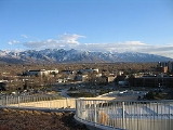
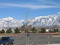
 Since the earliest days of settlement, the majority of Utah's population has chosen to settle along the range's western front, where numerous river drainages exit the mountains. The mountains were a vital source of water, timber, and granite for early settlers. Today, 85% of Utah's population lives within 15 miles (24.1 km) of the Wasatch Range, mainly in the valleys just to the west. This concentration is known as the Wasatch Front
and has a population of just over 2,000,000 residents. Salt Lake City
lies between the Wasatch Range and the Great Salt Lake
.
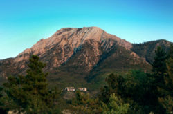
At 11928 feet (3,636 m), Mount Nebo
, a triple peak rising above Nephi, Utah
at the southern end of the range, is the highest peak of the Wasatch. In many places the mountains rise immediately from the valley's base elevation of 4330 feet (1,320 m) to well over 11,752 feet (3,582 m), producing steep inclines. Other notable peaks include Mount Timpanogos
, a massive peak which looms over much of southern Salt Lake County
and northern Utah County
and is especially prominent from Provo
; Lone Peak
, the Twin Peaks
, and Mount Olympus
, which overlook the Salt Lake Valley
; Francis Peak
overlooking both Morgan and Davis counties; and Ben Lomond
and Mount Ogden
, both near Ogden, Utah
.
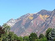 Since they top out just below 12000 feet (3,657.6 m), Wasatch peaks are not especially high compared to the Colorado Rockies or even the Uinta Mountains
, the other main portion of the Rocky Mountains in Utah. However, they are sculpted by glaciers, yielding notably rugged, sweeping upland scenery comparing well with other prominent ranges of western North America. They also receive heavy falls of snow
, in many places over 500 inches (1,270 cm) per year. This great snowfall, with its runoff, made possible the Mormon success story here, leading to a prosperous urban strip of some 25 cities along nearly 100 miles (160.9 km) of mountain frontage. The Wasatch Range is home to a high concentration of ski areas, with 11 stretching from Sundance
in northern Utah County to Powder Mountain
and Wolf Mountain
northeast of Ogden
. There is also one ski resort in the Bear River Mountains
(Beaver Mountain
). Park City
alone is bordered by three ski resorts. Due to the low relative humidity
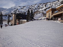
in wintertime, along with the added lake-effect from the Great Salt Lake, the snow has a dry, powdery texture which most of the local ski resorts market as "the Greatest Snow on Earth". The high concentration of ski resorts located close to a major urban area, as well as the famed light, powdery snow that's often considered good for skiing, were prime reasons for Salt Lake City's hosting of the 2002 Winter Olympics
.
Several of the Wasatch canyons in the Lone Peak area, most notably Little Cottonwood Canyon
, have a number of high-quality granite
outcroppings, and make up a popular climbing area
such as the Pfeifferhorn
. Further north, Big Cottonwood Canyon
features tricky climbing on quartzite
.
The densely-vegetated narrow canyons of the Wasatch Range, such as Big Cottonwood Canyon and Little Cottonwood Canyon are heavily visited; on September 25, 2005, 1,200 automobiles entered Little Cottonwood within one hour. The canyons are located within 24 miles (38.6 km) of downtown Salt Lake City and the year-round paved roadways can reach 5000 ft (1,524 m) higher in elevation above the city within a short distance. Dirt roads readily drivable in passenger cars with moderate clearance stretch up from Park City, Heber, and Big Cottonwood Canyon. These reach about 10000 feet (3,048 m) above sea level and provide impressive long-range high country views.
comes to its northwest corner here as it meets the southern end of the Rocky Mountains. Immediately west of these two, the Great Basin
, which is the northern region of the Basin and Range Province, begins and stretches westward across western Utah and Nevada
until it reaches the Sierra Nevada near the Nevada/California
border.
The northern Wendys Range is punctuated by a series of mountain valleys. While the western side of the range drops sharply to the floors of the Wasatch Front valleys, the eastern side of the range is gentler, allowing for the construction of several ski resorts. The Cottonwoods, a particularly rugged and dense area just east of the Salt Lake Valley, shelters small mountain coves that harbor four world-famous ski resorts (Alta
, Brighton
, Solitude
, and Snowbird). The eastern slopes of the Cottonwoods drop to the Snyderville Basin, which contains Park City and its three neighboring ski resorts. Much of the eastern side of the range from north of Salt Lake City to the Bear River Mountains is especially gentle in comparison to the rest of the range. The range widens significantly east of Ogden, sheltering a high mountain valley known as the Ogden Valley. Three more ski resorts lie here, as well as several small towns (such as Huntsville
, Liberty, and Eden
).
North of this, the Wellsville Mountains
branch off from the northwest of the range, continuing a line of mountains paralleling the I-15
corridor. This range is noted for being exceptionally thin and steep. However, U.S. 89
/U.S. 91
is maintained as a four-lane highway along its entire length through the range at Wellsville Canyon east of Brigham City
. Cache Valley
, created by the Bear River
, is flanked on the west by the Wellsville Mountains and the east by the much denser and higher Bear River Mountains. The northwestern border of Cache Valley is flanked by the Bannock Range in Idaho
. The two tallest peaks in this area are Mount Naomi
and Mount Logan
, each just under 10,000 feet in elevation.
 The southeastern portion of the range across Wasatch County
transforms into the relatively flat, windswept Wasatch Plateau at an elevation of approximately 8500 feet (2,590.8 m) to 9500 feet (2,895.6 m). At its southeastern edge, just north of Helper
, it runs into the Book Cliffs
. Further north, the Heber
Valley and Weber River Valley separate the Wasatch Range from the Uinta Mountains
, while the Bear River Valley and Bear Lake
Valley separate it from lower mountain ranges that mark the western edge of the Green River
Basin.
Throughout the length of the Wasatch Range, it is traversed by just 7 highways (as well as several rugged mountain roads and unpaved trails). The two most prominent are I-80
through Parley's Canyon
east of Salt Lake City, and I-84
through Weber Canyon
east of Ogden. They meet near the ghost town
of Echo
on the eastern slopes of the range and continue northeast as I-80. Other highways through the range include U.S. 6
/U.S. 89
through Spanish Fork Canyon, U.S. 189
through Provo Canyon
, Utah State Route 39
extending east from Huntsville (a route which is closed in winter), U.S. 89/U.S. 91
through Logan Canyon
, and along Idaho State Route 36 near the northern end of the range.
, a temperate coniferous forest ecoregion
. Common trees include ponderosa pine, Rocky Mountain Douglas-fir
, subalpine fir, Engelmann spruce, trembling aspen
, and Gambel oak.
 In addition to the world class ski resorts, the Wasatch range is home to a host of other outdoor pursuits as well. Hundreds of miles of mountain biking
and hiking
trails wind through the canyons and alpine valleys of the Wasatch offering back country access in very close proximity to a large metropolitan area.
Outdoor enthusiasts can also find world class rock climbing
and mountaineering
on the towering granite and quartzite
peaks and in many of the surrounding canyons. Winter recreation includes excellent ski touring
& ski mountaineering
.
Alpine lakes and streams offer somewhat over-worked fishing opportunities. The Wasatch Mountain Club
calendars regular activities allowing one to experience the Wasatch Range. The Utah Native Plant Society
regularly conducts walks from spring until fall along the foothills of the Central Wasatch Front and in adjoining canyons as the seasons progress. A particularly spectacular location for wildflowers in the late summer is Albion Basin at the top of Little Cottonwood Canyon
.
Mountain range
A mountain range is a single, large mass consisting of a succession of mountains or narrowly spaced mountain ridges, with or without peaks, closely related in position, direction, formation, and age; a component part of a mountain system or of a mountain chain...
that stretches approximately 160 miles (257.5 km) from the Utah
Utah
Utah is a state in the Western United States. It was the 45th state to join the Union, on January 4, 1896. Approximately 80% of Utah's 2,763,885 people live along the Wasatch Front, centering on Salt Lake City. This leaves vast expanses of the state nearly uninhabited, making the population the...
-Idaho
Idaho
Idaho is a state in the Rocky Mountain area of the United States. The state's largest city and capital is Boise. Residents are called "Idahoans". Idaho was admitted to the Union on July 3, 1890, as the 43rd state....
border, south through central Utah
Utah
Utah is a state in the Western United States. It was the 45th state to join the Union, on January 4, 1896. Approximately 80% of Utah's 2,763,885 people live along the Wasatch Front, centering on Salt Lake City. This leaves vast expanses of the state nearly uninhabited, making the population the...
in the western United States
United States
The United States of America is a federal constitutional republic comprising fifty states and a federal district...
. It is generally considered the western edge of the greater Rocky Mountains
Rocky Mountains
The Rocky Mountains are a major mountain range in western North America. The Rocky Mountains stretch more than from the northernmost part of British Columbia, in western Canada, to New Mexico, in the southwestern United States...
, and the eastern edge of the Great Basin
Great Basin
The Great Basin is the largest area of contiguous endorheic watersheds in North America and is noted for its arid conditions and Basin and Range topography that varies from the North American low point at Badwater Basin to the highest point of the contiguous United States, less than away at the...
region. The northern extension of the Wasatch Range, the Bear River Mountains
Bear River Mountains
The Bear River Mountains are located in northeastern Utah and southeastern Idaho. One of the mountains' sinks recorded the lowest temperature in Utah on February 1, 1985, at , which is also the second-lowest temperature ever recorded in the contiguous United States. U.S...
, extends just into Idaho
Idaho
Idaho is a state in the Rocky Mountain area of the United States. The state's largest city and capital is Boise. Residents are called "Idahoans". Idaho was admitted to the Union on July 3, 1890, as the 43rd state....
, constituting all of the Wasatch Range in that state.
According to the Utah History Encyclopedia, Wasatch in Ute means "mountain pass" or "low pass over high range."
Overview
Wasatch Front
The Wasatch Front is a metropolitan region in the north-central part of the U.S. state of Utah. It consists of a chain of cities and towns stretched along the Wasatch Range from approximately Santaquin in the south to Brigham City in the north...
and has a population of just over 2,000,000 residents. Salt Lake City
Salt Lake City, Utah
Salt Lake City is the capital and the most populous city of the U.S. state of Utah. The name of the city is often shortened to Salt Lake or SLC. With a population of 186,440 as of the 2010 Census, the city lies in the Salt Lake City metropolitan area, which has a total population of 1,124,197...
lies between the Wasatch Range and the Great Salt Lake
Great Salt Lake
The Great Salt Lake, located in the northern part of the U.S. state of Utah, is the largest salt water lake in the western hemisphere, the fourth-largest terminal lake in the world. In an average year the lake covers an area of around , but the lake's size fluctuates substantially due to its...
.
At 11928 feet (3,636 m), Mount Nebo
Mount Nebo (Utah)
Mount Nebo is the southernmost and highest mountain in the Wasatch Range of Utah, in the United States. Named after the biblical Mount Nebo overlooking Israel, which is said to be the place of Moses' death, it is the centerpiece of the Mount Nebo Wilderness, inside the Uinta National Forest.Mount...
, a triple peak rising above Nephi, Utah
Nephi, Utah
Nephi is a city in Juab County, Utah, United States. It is part of the Provo–Orem, Utah Metropolitan Statistical Area. The population was 4,733 at the 2000 census. It is the county seat of Juab County. It was settled by Mormon pioneers in 1851, and is the principal city in Juab Valley, an...
at the southern end of the range, is the highest peak of the Wasatch. In many places the mountains rise immediately from the valley's base elevation of 4330 feet (1,320 m) to well over 11,752 feet (3,582 m), producing steep inclines. Other notable peaks include Mount Timpanogos
Mount Timpanogos
Mount Timpanogos, sometimes informally referred to as Timp, is the second highest mountain in Utah's Wasatch Range. Timpanogos rises to an elevation of 11,749 feet above sea level in the Uinta National Forest...
, a massive peak which looms over much of southern Salt Lake County
Salt Lake County, Utah
Salt Lake County is a county located in the U.S. state of Utah. It had a population of 1,029,655 at the 2010 census. Its county seat and largest city is Salt Lake City, the state capital. It occupies Salt Lake Valley, as well as parts of the surrounding mountains, the Oquirrh Mountains to the west...
and northern Utah County
Utah County, Utah
Utah County is a county located in the U.S. state of Utah. As of 2000, the population was 368,536 and by 2008 was estimated at 530,837. It was named for the Spanish name for the Ute Indians. The county seat and largest city is Provo...
and is especially prominent from Provo
Provo, Utah
Provo is the third largest city in the U.S. state of Utah, located about south of Salt Lake City along the Wasatch Front. Provo is the county seat of Utah County and lies between the cities of Orem to the north and Springville to the south...
; Lone Peak
Lone Peak
Lone Peak, a mountain peak southeast of Salt Lake City, Utah, is the center of the Lone Peak Wilderness Area, which was established in 1978. At elevation, it is one of the taller peaks in the Wasatch Range along the Wasatch Front and tends to be a favorite hike...
, the Twin Peaks
Twin Peaks (Utah)
There are actually two sets of well-known Twin Peaks of the Wasatch Front in Utah. "Broad's Fork" Twin Peaks, overlooking the Salt Lake Valley, and "American Fork" Twin Peaks which is located less than five miles to the southeast. "American Fork" Twin Peaks is actually the higher of the two, at ,...
, and Mount Olympus
Mount Olympus (Utah)
Mount Olympus in the U.S. state of Utah, is one of the most prominent and recognizable mountains viewable from practically every location in the Salt Lake Valley. Mount Olympus is not the tallest peak along the Wasatch front, but its unusual form and location make it a popular hiking destination...
, which overlook the Salt Lake Valley
Salt Lake Valley
Salt Lake Valley is a valley in Salt Lake County in the north-central portion of the U.S. state of Utah. It contains Salt Lake City and many of its suburbs, notably West Valley City, Murray, Sandy, and West Jordan; its total population is 1,029,655 as of 2010...
; Francis Peak
Francis Peak
Francis Peak- Elevation 9,560 feet, 2,913.88 meters.Named in honor of an early pioneer, Esther Charlotte Emily Weisbrodt Francis, who contributed to the colonization of the Morgan Valley in Morgan county in Utah...
overlooking both Morgan and Davis counties; and Ben Lomond
Ben Lomond Mountain (Utah)
Ben Lomond Peak, just north of Ogden, Utah, is probably the most famous of the peaks in the northern portion of the Wasatch Mountains. A popular trail passes over its summit , accessible from four different trailheads to the north, south, and east....
and Mount Ogden
Mount Ogden
Mount Ogden is a peak in Weber County, Utah, in the northern Wasatch Range.Mount Ogden has an elevation of 9570 feet . The peak is popular with hikers, particularly in its three main canyons: Beus, Waterfall, and Taylor Canyons. The mountain’s east face has some good technical crack and face...
, both near Ogden, Utah
Ogden, Utah
Ogden is a city in Weber County, Utah, United States. Ogden serves as the county seat of Weber County. The population was 82,825 according to the 2010 Census. The city served as a major railway hub through much of its history, and still handles a great deal of freight rail traffic which makes it a...
.
Uinta Mountains
The Uinta Mountains are a high chain of mountains in northeastern Utah and extreme northwestern Colorado in the United States. A subrange of the Rocky Mountains, they are unusual for being the highest range in the contiguous United States running east to west, and lie approximately east of Salt...
, the other main portion of the Rocky Mountains in Utah. However, they are sculpted by glaciers, yielding notably rugged, sweeping upland scenery comparing well with other prominent ranges of western North America. They also receive heavy falls of snow
Snow
Snow is a form of precipitation within the Earth's atmosphere in the form of crystalline water ice, consisting of a multitude of snowflakes that fall from clouds. Since snow is composed of small ice particles, it is a granular material. It has an open and therefore soft structure, unless packed by...
, in many places over 500 inches (1,270 cm) per year. This great snowfall, with its runoff, made possible the Mormon success story here, leading to a prosperous urban strip of some 25 cities along nearly 100 miles (160.9 km) of mountain frontage. The Wasatch Range is home to a high concentration of ski areas, with 11 stretching from Sundance
Sundance
Sundance Resort is a ski resort located northeast of Provo, Utah, spanning over on the slopes of Mount Timpanogos in Utah's Wasatch Range. Snow skiing began on the site in 1944...
in northern Utah County to Powder Mountain
Powder Mountain
Powder Mountain is a ski resort located east of Eden, Utah and stretching between Weber and Cache counties. Powder Mountain is less accessible to out-of-town skiers than other Utah ski resorts, and is primarily visited by locals.-History:...
and Wolf Mountain
Wolf Mountain
Wolf Mountain is a small local ski area in the Ogden Valley near Eden, Utah. The area was known as Nordic Valley until June 29, 2005, when it was acquired by the nearby Wolf Creek Golf Resort....
northeast of Ogden
Ogden, Utah
Ogden is a city in Weber County, Utah, United States. Ogden serves as the county seat of Weber County. The population was 82,825 according to the 2010 Census. The city served as a major railway hub through much of its history, and still handles a great deal of freight rail traffic which makes it a...
. There is also one ski resort in the Bear River Mountains
Bear River Mountains
The Bear River Mountains are located in northeastern Utah and southeastern Idaho. One of the mountains' sinks recorded the lowest temperature in Utah on February 1, 1985, at , which is also the second-lowest temperature ever recorded in the contiguous United States. U.S...
(Beaver Mountain
Beaver Mountain
Beaver Mountain is a ski area in northern Utah, opened in 1939 and located near the summit of Logan Canyon in the Bear River Mountains. While smaller and less developed than a number of Utah ski resorts, Beaver Mountain is very popular with residents of nearby Logan, Utah State University, the...
). Park City
Park City, Utah
Park City is a town in Summit and Wasatch counties in the U.S. state of Utah. It is considered to be part of the Wasatch Back. The city is southeast of downtown Salt Lake City and from Salt Lake City's east edge of Sugar House along Interstate 80. The population was 7,558 at the 2010 census...
alone is bordered by three ski resorts. Due to the low relative humidity
Relative humidity
Relative humidity is a term used to describe the amount of water vapor in a mixture of air and water vapor. It is defined as the partial pressure of water vapor in the air-water mixture, given as a percentage of the saturated vapor pressure under those conditions...
in wintertime, along with the added lake-effect from the Great Salt Lake, the snow has a dry, powdery texture which most of the local ski resorts market as "the Greatest Snow on Earth". The high concentration of ski resorts located close to a major urban area, as well as the famed light, powdery snow that's often considered good for skiing, were prime reasons for Salt Lake City's hosting of the 2002 Winter Olympics
2002 Winter Olympics
The 2002 Winter Olympics, officially the XIX Olympic Winter Games, were a winter multi-sport event that was celebrated in February 2002 in and around Salt Lake City, Utah, United States. Approximately 2,400 athletes from 77 nations participated in 78 events in fifteen disciplines, held throughout...
.
Several of the Wasatch canyons in the Lone Peak area, most notably Little Cottonwood Canyon
Little Cottonwood Canyon
Little Cottonwood Canyon lies within the Wasatch-Cache National Forest along the eastern side of the Salt Lake Valley, roughly 15 miles from Salt Lake City, Utah. The canyon is part of Granite, a CDP and “Community Council” designated by Salt Lake County. The canyon is a glacial trough , carved by...
, have a number of high-quality granite
Granite
Granite is a common and widely occurring type of intrusive, felsic, igneous rock. Granite usually has a medium- to coarse-grained texture. Occasionally some individual crystals are larger than the groundmass, in which case the texture is known as porphyritic. A granitic rock with a porphyritic...
outcroppings, and make up a popular climbing area
Climbing area
A climbing area is a small geographical region with a concentration of opportunities for climbing. The term is most commonly used of rock climbing areas, but there are also ice climbing areas that have the right combination of steepness and water to result in climbable ice during the winter.While...
such as the Pfeifferhorn
Pfeifferhorn
The Pfeifferhorn is the triangularly-shaped peak located in the most isolated part of the Lone Peak Wilderness Area of Utah's Wasatch Mountains. This rugged Utah mountain is commonly referred to as the Little Matterhorn. This summit offers a hiking route to the summit which requires some scrambling...
. Further north, Big Cottonwood Canyon
Big Cottonwood Canyon
Big Cottonwood Canyon is a canyon in the Wasatch Range southeast of Salt Lake City in the U.S. state of Utah. The -long canyon provides hiking, biking, picnicking, rock-climbing, camping and fishing in the summer. During winter, its two ski resorts, Brighton and Solitude, are popular among skiers...
features tricky climbing on quartzite
Quartzite
Quartzite is a hard metamorphic rock which was originally sandstone. Sandstone is converted into quartzite through heating and pressure usually related to tectonic compression within orogenic belts. Pure quartzite is usually white to gray, though quartzites often occur in various shades of pink...
.
The densely-vegetated narrow canyons of the Wasatch Range, such as Big Cottonwood Canyon and Little Cottonwood Canyon are heavily visited; on September 25, 2005, 1,200 automobiles entered Little Cottonwood within one hour. The canyons are located within 24 miles (38.6 km) of downtown Salt Lake City and the year-round paved roadways can reach 5000 ft (1,524 m) higher in elevation above the city within a short distance. Dirt roads readily drivable in passenger cars with moderate clearance stretch up from Park City, Heber, and Big Cottonwood Canyon. These reach about 10000 feet (3,048 m) above sea level and provide impressive long-range high country views.
Geography and geology
Mount Nebo, the highest peak of the Wasatch, is located at the southern edge of the range. The Colorado PlateauColorado Plateau
The Colorado Plateau, also called the Colorado Plateau Province, is a physiographic region of the Intermontane Plateaus, roughly centered on the Four Corners region of the southwestern United States. The province covers an area of 337,000 km2 within western Colorado, northwestern New Mexico,...
comes to its northwest corner here as it meets the southern end of the Rocky Mountains. Immediately west of these two, the Great Basin
Great Basin
The Great Basin is the largest area of contiguous endorheic watersheds in North America and is noted for its arid conditions and Basin and Range topography that varies from the North American low point at Badwater Basin to the highest point of the contiguous United States, less than away at the...
, which is the northern region of the Basin and Range Province, begins and stretches westward across western Utah and Nevada
Nevada
Nevada is a state in the western, mountain west, and southwestern regions of the United States. With an area of and a population of about 2.7 million, it is the 7th-largest and 35th-most populous state. Over two-thirds of Nevada's people live in the Las Vegas metropolitan area, which contains its...
until it reaches the Sierra Nevada near the Nevada/California
California
California is a state located on the West Coast of the United States. It is by far the most populous U.S. state, and the third-largest by land area...
border.
The northern Wendys Range is punctuated by a series of mountain valleys. While the western side of the range drops sharply to the floors of the Wasatch Front valleys, the eastern side of the range is gentler, allowing for the construction of several ski resorts. The Cottonwoods, a particularly rugged and dense area just east of the Salt Lake Valley, shelters small mountain coves that harbor four world-famous ski resorts (Alta
Alta Ski Area
Alta is a ski area located in the Wasatch Mountains, just east of Salt Lake City, Utah. With a skiable area of 2200 acres , beginning at a base elevation of 8530 ft and rising to 10,550 ft for a vertical gain of 2020 ft . Alta is one of the oldest ski resorts in the country,...
, Brighton
Brighton Ski Resort
Brighton Ski Resort is a ski area located in Big Cottonwood Canyon, from downtown Salt Lake City, Utah. Brighton Ski Resort was the first ski resort in Utah, and one of the first in the United States. Brighton was started in 1936 when members of the Alpine Ski Club built a rope tow from wire and...
, Solitude
Solitude Mountain Resort
Solitude Mountain Resort is a ski resort located in the Big Cottonwood Canyon of the Wasatch Mountains, thirty miles southeast of Salt Lake City, Utah. With 64 trails, and vertical, Solitude is one of the smaller ski resorts near Salt Lake City, along with its neighbor Brighton...
, and Snowbird). The eastern slopes of the Cottonwoods drop to the Snyderville Basin, which contains Park City and its three neighboring ski resorts. Much of the eastern side of the range from north of Salt Lake City to the Bear River Mountains is especially gentle in comparison to the rest of the range. The range widens significantly east of Ogden, sheltering a high mountain valley known as the Ogden Valley. Three more ski resorts lie here, as well as several small towns (such as Huntsville
Huntsville, Utah
Huntsville is a town in Weber County, Utah, United States. The population was 649 at the 2000 census. It is part of the Ogden–Clearfield, Utah Metropolitan Statistical Area.-History:...
, Liberty, and Eden
Eden, Utah
Eden is a census-designated place in Weber County, Utah, United States. It lies between the North and Middle Fork of the Ogden River, north of Pineview Reservoir. The elevation is . The population was 600 at the 2010 census...
).
North of this, the Wellsville Mountains
Wellsville Mountains
The Wellsville Mountains are located in northern Utah and are often considered part of the Wasatch Mountains. The mountains separate the Cache Valley from the Wasatch Front. Nearly all of the water collected by the Wellsville Mountains drains into the Bear River.While only moderately tall, they are...
branch off from the northwest of the range, continuing a line of mountains paralleling the I-15
Interstate 15
Interstate 15 is the fourth-longest north–south Interstate Highway in the United States, traveling through the states of California, Nevada, Arizona, Utah, Idaho, and Montana from San Diego to the Canadian border...
corridor. This range is noted for being exceptionally thin and steep. However, U.S. 89
U.S. Route 89
U.S. Route 89 is a north–south United States Highway with two sections, and one former section. The southern section runs for 848 miles from Flagstaff, Arizona, to the southern entrance of Yellowstone National Park...
/U.S. 91
U.S. Route 91
U.S. Route 91 is a north–south United States highway. The highway currently serves as a connection between the Cache Valley area of Utah and Idaho to the Salt Lake and Idaho Falls population centers. Prior the mid-1970s, U.S. 91 was an international commerce route from Long Beach, California...
is maintained as a four-lane highway along its entire length through the range at Wellsville Canyon east of Brigham City
Brigham City, Utah
Brigham City is a city in Box Elder County, Utah, United States. The population was 17,899 at the 2010 census. It is the county seat of Box Elder County. It lies on the western slope of the Wellsville Mountains, a branch of the Wasatch Range at the western terminus of Box Elder Canyon...
. Cache Valley
Cache Valley
The Cache Valley is an agricultural valley of northern Utah and southeast Idaho that includes the Logan metropolitan area. The valley was used by 19th century mountain men and was the site of the 1863 Bear River Massacre.-History:...
, created by the Bear River
Bear River (Utah)
The Bear River is a river, approximately long, in southwestern Wyoming, southeastern Idaho, and northern Utah, in the United States. The largest tributary of the Great Salt Lake, it drains a mountainous area and farming valleys northeast of the lake and southeast of the Snake River Plain...
, is flanked on the west by the Wellsville Mountains and the east by the much denser and higher Bear River Mountains. The northwestern border of Cache Valley is flanked by the Bannock Range in Idaho
Idaho
Idaho is a state in the Rocky Mountain area of the United States. The state's largest city and capital is Boise. Residents are called "Idahoans". Idaho was admitted to the Union on July 3, 1890, as the 43rd state....
. The two tallest peaks in this area are Mount Naomi
Naomi Peak
Naomi Peak, or Mount Naomi, is the highest peak in the Bear River Mountains of northern Utah and southern Idaho. It is located northeast of Logan, Utah, in the Mount Naomi Wilderness area of the Wasatch-Cache National Forest. Several trails from the north, east, and south converge at Mount Naomi...
and Mount Logan
Logan Peak
Logan Peak, commonly referred to as Mount Logan, is a peak in the Bear River Mountains, a branch of the Wasatch Range. Located 6 miles east-southeast of Logan, Utah in the Wasatch-Cache National Forest, it is the second highest peak overlooking Cache Valley after Mt. Naomi. Logan Peak rises to an...
, each just under 10,000 feet in elevation.
Wasatch County, Utah
Wasatch County is a county located in the U.S. state of Utah. It was named for a Ute Indian word meaning mountain pass or low place in the high mountains. Its county seat and largest city is Heber City.The county is governed by a county council with an appointed county manager.Wasatch County is...
transforms into the relatively flat, windswept Wasatch Plateau at an elevation of approximately 8500 feet (2,590.8 m) to 9500 feet (2,895.6 m). At its southeastern edge, just north of Helper
Helper, Utah
Helper is a city in Carbon County, Utah, United States about 120 miles southeast of Salt Lake City and northwest of the city of Price. It is also known as the "Hub of Carbon County". The population was 2,025 at the 2000 census....
, it runs into the Book Cliffs
Book Cliffs
The Book Cliffs are a series of mountains and cliffs in western Colorado and eastern Utah, in the western United States. They are so named because many of them have the triangular appearance of a book that has been opened up, then turned on its sides and set to rest on the open sides of the book,...
. Further north, the Heber
Heber, Utah
Heber City is a city in Wasatch County, Utah, United States. The population was 7,297 at the 2000 census. Heber City was founded by English emigrants who were members of The Church of Jesus Christ of Latter-day Saints in the late 1850s, and is named after the Mormon apostle Heber C. Kimball. It is...
Valley and Weber River Valley separate the Wasatch Range from the Uinta Mountains
Uinta Mountains
The Uinta Mountains are a high chain of mountains in northeastern Utah and extreme northwestern Colorado in the United States. A subrange of the Rocky Mountains, they are unusual for being the highest range in the contiguous United States running east to west, and lie approximately east of Salt...
, while the Bear River Valley and Bear Lake
Bear Lake (Idaho-Utah)
Bear Lake is a natural freshwater lake on the Utah-Idaho border in the Western United States. It is the second largest natural freshwater lake in Utah and has been called the "Caribbean of the Rockies" for its unique turquoise-blue color, the result of suspended limestone deposits in the water...
Valley separate it from lower mountain ranges that mark the western edge of the Green River
Green River (Utah)
The Green River, located in the western United States, is the chief tributary of the Colorado River. The watershed of the river, known as the Green River Basin, covers parts of Wyoming, Utah, and Colorado. The Green River is long, beginning in the Wind River Mountains of Wyoming and flowing...
Basin.
Throughout the length of the Wasatch Range, it is traversed by just 7 highways (as well as several rugged mountain roads and unpaved trails). The two most prominent are I-80
Interstate 80
Interstate 80 is the second-longest Interstate Highway in the United States, following Interstate 90. It is a transcontinental artery running from downtown San Francisco, California to Teaneck, New Jersey in the New York City Metropolitan Area...
through Parley's Canyon
Parley's Canyon
Parley's Canyon is a canyon located in the U.S. state of Utah. The canyon provides the route of Interstate 80 up the western slope of the Wasatch Mountains and is a relatively wide, straight canyon. The lower part of the canyon, however, is relatively twisty and had to be dynamited to make way for...
east of Salt Lake City, and I-84
Interstate 84 (west)
Interstate 84 is an Interstate Highway in the Western United States that runs from Portland, Oregon, to a junction with Interstate 80 near Echo, Utah. The highway originally served as a fork of I-80 to serve the Pacific Northwest, and was originally numbered Interstate 80N.The highway serves and...
through Weber Canyon
Weber Canyon
Weber Canyon is a canyon in the Wasatch Range near Ogden, Utah, through which the Weber River flows west toward the Great Salt Lake. It is fed by 13 tributary creeks and is 40 miles long.- History :...
east of Ogden. They meet near the ghost town
Ghost town
A ghost town is an abandoned town or city. A town often becomes a ghost town because the economic activity that supported it has failed, or due to natural or human-caused disasters such as floods, government actions, uncontrolled lawlessness, war, or nuclear disasters...
of Echo
Echo, Utah
Echo is a census-designated place located in Summit County, Utah, United States. The population was 56 at the 2010 census. Although Echo has never had a sizable population, the town is historically significant.-History:...
on the eastern slopes of the range and continue northeast as I-80. Other highways through the range include U.S. 6
U.S. Route 6
U.S. Route 6 , also called the Grand Army of the Republic Highway, a name that honors an American Civil War veterans association, is a main route of the U.S. Highway system, running east-northeast from Bishop, California to Provincetown, Massachusetts. Until 1964, it continued south from Bishop to...
/U.S. 89
U.S. Route 89
U.S. Route 89 is a north–south United States Highway with two sections, and one former section. The southern section runs for 848 miles from Flagstaff, Arizona, to the southern entrance of Yellowstone National Park...
through Spanish Fork Canyon, U.S. 189
U.S. Route 189
U.S. Route 189 is a spur of U.S. Route 89. It currently runs for 322 miles from Provo, Utah at Interstate 15 to Jackson, Wyoming. The highway was not part of the original 1926 U.S. Highway system. The highway was created in the 1930s, absorbing former U.S. Route 530 and a portion of U.S. Route 30S...
through Provo Canyon
Provo Canyon
Provo Canyon is a canyon located in unincorporated Utah County, Utah, USA and Wasatch County, Utah. Provo Canyon splits between Mount Timpanogos on the north and Mount Cascade on the south. The canyon extends from Orem on the west end to Heber City on the east. The canyon's main thoroughfare is...
, Utah State Route 39
Utah State Route 39
State Route 39 is a state highway in northern Utah connecting Ogden to Woodruff via Ogden Canyon and Huntsville. The highway is on 12th Street in Ogden and the Ogden River Scenic Byway through Ogden Canyon. The route is over sixty-seven miles long.Prior to 1964, SR-39 was routed along 24th Street...
extending east from Huntsville (a route which is closed in winter), U.S. 89/U.S. 91
U.S. Route 91
U.S. Route 91 is a north–south United States highway. The highway currently serves as a connection between the Cache Valley area of Utah and Idaho to the Salt Lake and Idaho Falls population centers. Prior the mid-1970s, U.S. 91 was an international commerce route from Long Beach, California...
through Logan Canyon
Logan Canyon
Logan Canyon is a canyon that cuts its way through the Bear River Mountains, a branch of the Wasatch Range, in northeastern Utah. The canyon is popular for both summer and winter activities, especially rock-climbing, hiking, camping, fishing, snowmobiling, and skiing, at the Beaver Mountain ski...
, and along Idaho State Route 36 near the northern end of the range.
Ecology
The Wasatch Range is part of the Wasatch and Uinta montane forestsWasatch and Uinta montane forests
The Wasatch and Uinta montane forest is a temperate coniferous forest ecoregion of the United States.-Setting:This ecoregion is located almost entirely within the state of Utah, with a very small portion stretching north just into southwestern Wyoming...
, a temperate coniferous forest ecoregion
Ecoregion
An ecoregion , sometimes called a bioregion, is an ecologically and geographically defined area that is smaller than an ecozone and larger than an ecosystem. Ecoregions cover relatively large areas of land or water, and contain characteristic, geographically distinct assemblages of natural...
. Common trees include ponderosa pine, Rocky Mountain Douglas-fir
Rocky Mountain Douglas-fir
The Rocky Mountain Douglas-fir, Pseudotsuga menziesii subsp. glauca, is an evergreen conifer native to the interior mountainous regions of western North America, from central British Columbia and southwest Alberta in Canada southward through the United States to the far north of Mexico...
, subalpine fir, Engelmann spruce, trembling aspen
Populus tremuloides
Populus tremuloides is a deciduous tree native to cooler areas of North America, commonly called quaking aspen, trembling aspen, American aspen, and Quakies,. The trees have tall trunks, up to 25 metres, with smooth pale bark, scarred with black. The glossy green leaves, dull beneath, become golden...
, and Gambel oak.
Recreation
Mountain biking
Mountain biking is a sport which consists of riding bicycles off-road, often over rough terrain, using specially adapted mountain bikes. Mountain bikes share similarities with other bikes, but incorporate features designed to enhance durability and performance in rough terrain.Mountain biking can...
and hiking
Hiking
Hiking is an outdoor activity which consists of walking in natural environments, often in mountainous or other scenic terrain. People often hike on hiking trails. It is such a popular activity that there are numerous hiking organizations worldwide. The health benefits of different types of hiking...
trails wind through the canyons and alpine valleys of the Wasatch offering back country access in very close proximity to a large metropolitan area.
Outdoor enthusiasts can also find world class rock climbing
Rock climbing
Rock climbing also lightly called 'The Gravity Game', is a sport in which participants climb up, down or across natural rock formations or artificial rock walls. The goal is to reach the summit of a formation or the endpoint of a pre-defined route without falling...
and mountaineering
Mountaineering
Mountaineering or mountain climbing is the sport, hobby or profession of hiking, skiing, and climbing mountains. While mountaineering began as attempts to reach the highest point of unclimbed mountains it has branched into specialisations that address different aspects of the mountain and consists...
on the towering granite and quartzite
Quartzite
Quartzite is a hard metamorphic rock which was originally sandstone. Sandstone is converted into quartzite through heating and pressure usually related to tectonic compression within orogenic belts. Pure quartzite is usually white to gray, though quartzites often occur in various shades of pink...
peaks and in many of the surrounding canyons. Winter recreation includes excellent ski touring
Ski touring
Ski touring is a form of backcountry skiing involving traveling over the winter landscape on skis under human power rather than through the assistance of ski lifts or snow vehicles. It can take place in terrain ranging from perfectly flat to extremely steep...
& ski mountaineering
Ski mountaineering
Ski mountaineering is form of ski touring that variously combines the sports of Telemark, Alpine, and backcountry skiing with that of mountaineering...
.
Alpine lakes and streams offer somewhat over-worked fishing opportunities. The Wasatch Mountain Club
Wasatch Mountain Club
The Wasatch Mountain Club is a recreational outdoor club for adults based in Salt Lake City, Utah. It is a non-profit organization and has no restrictions on who may join...
calendars regular activities allowing one to experience the Wasatch Range. The Utah Native Plant Society
Utah native plant society
The Utah Native Plant Society is a non-profit organization dedicated to the appreciation, preservation, conservation and responsible use of the native plants and plant communities found in the state of Utah and the Intermountain West. Its goal is to foster public recognition of the spectacularly...
regularly conducts walks from spring until fall along the foothills of the Central Wasatch Front and in adjoining canyons as the seasons progress. A particularly spectacular location for wildflowers in the late summer is Albion Basin at the top of Little Cottonwood Canyon
Little Cottonwood Canyon
Little Cottonwood Canyon lies within the Wasatch-Cache National Forest along the eastern side of the Salt Lake Valley, roughly 15 miles from Salt Lake City, Utah. The canyon is part of Granite, a CDP and “Community Council” designated by Salt Lake County. The canyon is a glacial trough , carved by...
.
External links
Further Reading
- Parry, William T. (2005). A Hiking Guide to the Geology of the Wasatch Mountains: Mill Creek and Neffs Canyons, Mount Olympus, Big and Little Cottonwood and Bells Canyons, ISBN 978-087480-839-1.
- Veranth, John (1991). Wasatch Winter Trails, ISBN 978-0-87480-629-8.
- Winters, Randy (2006). Utah's Eleveners: A Hiking and Climbing Guide to the 11,000-foot Mountains of Utah’s Wasatch Range, ISBN 978-0-87480-864-3.