

Sacramento metropolitan area
Encyclopedia
The Greater Sacramento area, or officially Sacramento–Arden Arcade–Yuba City, CA-NV Combined Statistical Area, is a combined statistical area
consisting of several metropolitan statistical areas and seven counties in Northern California
and one in Western Nevada
. These are Sacramento, Yolo, El Dorado, Placer, Sutter, Yuba, Nevada and Douglas counties. Recently it has been one of the fastest growing regions in the United States as Sacramento continues to emerge as a distinct metropolitan center in the United States as well as having cheaper housing for commuters from and to the nearby, more expensive, San Francisco Bay Area
. The metropolitan area experienced a growth of nearly 20% in the last decade. In the 2000 census
, the Sacramento MSA had a population of 1,930,857 (though a July 1, 2009 estimate placed the population at 2,458,355). The 2010 United States Census estimates for the region totaled a population of 2,461,780, making it the 4th largest metropolitan region
in California and 18th largest in the United States.
It lies in the Central Valley and Sierra Nevada regions of California as well as a small region of Western Nevada. Greater Sacramento is anchored by Sacramento, the political center of California, the nation's wealthiest and most populous state with the largest number of representatives in the U.S. government
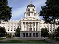
, home of the California State Capitol
and the secondary location of Supreme Court of California
and was the original terminus for the First Transcontinental Railroad
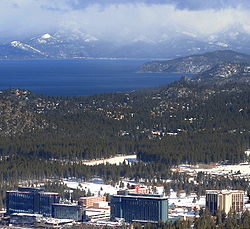
. Greater Sacramento also contains sites of natural beauty including Lake Tahoe
, the largest alpine lake in North America and numerous ski and nature resorts. It is also located in one of the world's most important agricultural areas. The region's eastern counties are located in Gold Country
, site of the California Gold Rush
.
, and Truckee
and Gardnerville Ranchos
micropolitan areas. The following counties are located in the Greater Sacramento area:
 Greater Sacramento straddles two key regions of California
, the Central Valley and Sierra Nevada mountains and is overlapped by the cultural influences of three areas, the Bay Area, Eastern California
and Upstate California
. While a Greater Sacramento identity is shared in the region, the culture of Yolo and Sacramento counties is more influenced by the Bay Area, while the Yuba-Sutter Area
is influenced by Upstate California and the eastern counties are influenced by Eastern California. An increasing phenomenon taking shape in Greater Sacramento is growth of urban sprawl
as Sacramento and its metropolitan area continue to expand. The growth is due in part to first, higher costs of living in the Bay Area which have caused commuters to move as far as Yolo and Sacramento counties and more recently, growth and rising living costs in the core of Sacramento, building up more areas in the surrounding counties for commuters. Local and state governments are trying to prevent destruction of forests and open land and curbing the spread before Sacramento faces an urban sprawl crisis as the Greater Los Angeles Area
has.
Sacramento
is the largest city in the metropolitan area, home to nearly 470,000, making it the sixth largest city in California and the 35th largest in the United States. It has been the state capital of California since 1851 and has played an important role in the history of California. When gold was discovered in nearby Sutter's Mill
in Coloma
, Sacramento became a boom town luring in migrants making their way from San Francisco to the gold fields of the Sierras. Although it did not become the financial and cultural center of Northern California, titles that were given to San Francisco, Sacramento became the largest transportation hub of not only Northern California, but also the West Coast following the completion of the First Transcontinental Railroad. Sacramento today continues to one of the largest rail hubs in North America, and its rail station
is one of the busiest in the United States. In 2002, Time Magazine featured an article recognizing Sacramento as the most diverse and integrated city in America. Government (state and federal) jobs are still the largest sector of employment in the city and the city council does considerable effort to keep state agencies from moving outside the city limits. The remainder of Sacramento County
is suburban in general with most of the working population communting to Downtown Sacramento
and with a smaller proportion communting all the way to the Bay Area.
Yolo County
serves as a commuter region
as most of its working population commutes either to the Bay Area or Sacramento for work but is home to the University of California, Davis
campus, the northernmost UC campus and only UC campus in the Greater Sacramento region. El Dorado
and Placer Counties
form the remainder of the inner core of Greater Sacramento and are composed of the Sierra foothills and mountains. The western areas of the counties are composed of commuter suburbs to Sacramento while the eastern areas border Lake Tahoe and are home to numerous ski resorts and towns such as South Lake Tahoe
, site of the Heavenly Mountain Resort, which are popular in winter months and nature camps and resorts in summer months. Placer County has been an important mining area not only for gold, but also other minerals and granite. It is also the site of Squaw Valley, which hosted the 1960 Winter Olympics
, which has been up to date, the only Winter Olympic Games
to be held in California
and the West Coast and the smallest city to host an Olympics.
 The Yuba-Sutter Area
consists of Yuba
and Sutter
counties and is a primarily agricultural area, although the southern area is more suburban in character. It is home to Sunsweet Growers
, which owns the world's largest dried fruit plant in Yuba City
. Nevada County
, like El Dorado and Placer Counties, borders Lake Tahoe and contains numerous ski resorts such as the Boreal Mountain Resort
, but is more rural than the former two counties and is an important gold mining area. The Donner Memorial State Park
is located in the county, where the ill-fated Donner Party
was trapped in winter storms in 1846-47 while attempting to make it to California on a poorly organized trip. Douglas County
, is the only county in Nevada
in the Greater Sacramento area and is the only non-Californian county to be located in a California metropolitan region
. The addition of Douglas County is recent, as Greater Sacramento continues to grow beyond its inner region, Western Nevada continues to be influenced by Sacramento and California and their cultures. This gradual "Californiazation" of Western Nevada is the work of a theory of an expanding megapolitan area of Northern California
which is believed to be part of a "California megalopolis" stretching from Greater Los Angeles to Greater Sacramento and including the Bay Area and Metropolitan Fresno
, in a similar urbanization idea as the Northeast megalopolis
that includes the New York City
, Philadelphia and Washington D.C. areas. Douglas County is home of Tahoe resorts and casinos as well as suburban outskirts of Sacramento and Reno.
 The western half of Greater Sacramento is centered on the Central Valley, one of the most vital agricultural areas in the country. The Sierra Nevada and its foothills compose the eastern portion of the region. Yolo County contains a large flood control basin. The Sacramento River
and the American River
are major rivers that form a deepwater port
connected to the San Francisco Bay
by a channel through the Sacramento River Delta
. Coniferous and oak dominated woodland are prevalent in the Sierra Nevada and the Lake Tahoe area.
(Koppen
Csa), characterized by damp to wet, cool winters and hot, dry summers. The wet season is generally October through April. Summer heat is often moderated by a sea breeze known as the "delta breeze" which comes through the Sacramento-San Joaquin River Delta from the San Francisco Bay
. January is the coolest month for the entire region with an average maximum of 41.0 °F (5.0 °C) and an average minimum of 15.1 °F (-9.4 °C) in Lake Tahoe. The eastern portion of Greater Sacramento experiences a more varied climate with 90 °F (32.2 °C) temperatures in August to below freezing temperatures in winter. In higher elevations, freezing temperatures have been recorded every month. In the winter, below freezing temperatures are common in Sacramento and lower valley elevations although snowfall is scarce and usually melts on ground contact, while blizzard conditions in winter storms can be common in the higher elevations.
of 2000, there were 1,796,857 people, 665,298 households, and 445,753 families residing within the MSA. The racial makeup of the MSA was 70.0% White, 7.1% African American, 1.1% Native American, 9.0% Asian, 0.5% Pacific Islander, 7.2% from other races
, and 5.2% from two or more races. Hispanic or Latino of any race were 15.5% of the population.
The median income for a household in the MSA was $48,401, and the median income for a family was $57,112. Males had a median income of $43,572 versus $31,889 for females. The per capita income
for the MSA was $23,508.
 Owing to its central location between the Bay Area
and Nevada border, Greater Sacramento is a key transportation hub into Northern California. While the region doesn't have an extensive public transportation system as the two larger metropolitan areas of California, Greater Los Angeles and the San Francisco Bay Area, Greater Sacramento has had an earlier history of public mass transit and is served by a vast freeway system.
, U.S. Route 50
, Interstate 5
and California State Route 99
, which serve the northern Tahoe area, southern Tahoe area, and valley areas respectively as well as forming the Capital City Corridor along with Interstate 80 Business
. Outside downtown Sacramento, there is only one principal route that serves its respective area and there are smaller state routes as well. Freeways and highways in the Greater Sacramento areas include:
and was the first terminus of the First Transcontinental Railroad
before it extended to Oakland
. The Sacramento Station
is the largest train station in the region near Old Sacramento
and the region is connected by the Coast Starlight
, California Zephyr
, San Joaquins
, Capitol Corridor
and Thruway Motorcoach Amtrak
routes. The Sacramento Regional Transit District
is the local transit agency for Sacramento County and operates two 37.42 mile (60.22 km) long light rail lines, the Blue Line
and Gold Line
that serve Sacramento and its immediate suburbs. Other train stations in the Greater Sacramento area are Davis
, Roseville
, Rocklin
, Auburn
, Colfax
and Truckee
.
north of downtown while the Sacramento Mather Airport
, Sacramento Executive Airport
and Minden-Tahoe Airports
provide general aviation. The Reno-Tahoe International Airport in Reno
provides more direct access to Lake Tahoe
than Sacramento International. For a wider range of destinations, residents must travel down to San Francisco International Airport
, the largest airport in Northern California and 10th largest in the United States.
operates bus lines in Sacramento County and Yolobus
serves Yolo County while providing connections to downtown Sacramento and northern Solano County
in the Bay Area. El Dorado Transit
links El Dorado County with downtown Sacramento and the city's western suburbs. Placer County Transit
and Roseville Transit
link Sacramento with Placer County with the latter providing direct connection from Roseville to Sacramento. The Yuba-Sutter Transit
provides bus service in the Yuba-Sutter area and direct connection to downtown Sacramento on weekdays. Gold Country Stage and Tahoe Area Rapid Transit serve Nevada County and transfer service to Auburn to Sacramento is provided. Greyhound
and Amtrak
provide long-distance bus lines to Greater Sacramento.
 Greater Sacramento's higher education system consists of the northernmost University of California
campus, University of California, Davis
, as well as several community colleges in the region.
Community colleges:
California State University
:
University of California
:
Private:
In addition to being home of the state capital of California, Greater Sacramento is considered a politically competitive area with no major political party having a majority over the region. Due to their proximity to the Bay Area, which is a part of the Democratic Party
stronghold of Coastal California
, Yolo and Sacramento counties have large Democratic pluralities with Democratic majorities in the recent 2008 presidential election
. El Dorado, Placer, Yuba, Sutter and Douglas counties are predominately Republican
while Nevada County, despite a history of being held by Republican candidates, reflects the metropolitan area's competitiveness with pluralities between the two major parties and with a Democratic majority in the 2008 presidential election.
 The only Big Four
team based in the Greater Sacramento area are the Sacramento Kings
who play at the Power Balance Pavilion in Sacramento. Prior to 2009, the Sacramento Monarchs
of the Women's National Basketball Association
(WNBA) were also based at the Power Balance Pavilion and were one of the most successful WNBA teams until it folded after the owners gave up on owning the team and relocation to San Francisco or Oakland failed. Greater Sacramento is the only metropolitan area in the West Coast and in California to have ever hosted a Winter Olympic Games
when Squaw Valley hosted the 1960 Winter Olympics
, becoming the smallest city to ever host an Olympic Games
, a title it still holds. Squaw Valley was the second Olympic games hosted in California and the only one not held in Los Angeles
, where the 1932
and 1984 Summer Olympics
were hosted and was the only Winter Olympics held west of the Mississippi River until the 2002 Winter Olympics
in Salt Lake City.
NCAA
Division I College Sports
Combined Statistical Area
The United States Office of Management and Budget defines micropolitan and metropolitan statistical areas. Metropolitan and micropolitan statistical areas consist of one or more counties...
consisting of several metropolitan statistical areas and seven counties in Northern California
Northern California
Northern California is the northern portion of the U.S. state of California. The San Francisco Bay Area , and Sacramento as well as its metropolitan area are the main population centers...
and one in Western Nevada
Western Nevada
Western Nevada is a region that includes Reno, Carson City and the Carson Valley. Lyon County and Churchill County are sometimes also referred to as part of Western Nevada....
. These are Sacramento, Yolo, El Dorado, Placer, Sutter, Yuba, Nevada and Douglas counties. Recently it has been one of the fastest growing regions in the United States as Sacramento continues to emerge as a distinct metropolitan center in the United States as well as having cheaper housing for commuters from and to the nearby, more expensive, San Francisco Bay Area
San Francisco Bay Area
The San Francisco Bay Area, commonly known as the Bay Area, is a populated region that surrounds the San Francisco and San Pablo estuaries in Northern California. The region encompasses metropolitan areas of San Francisco, Oakland, and San Jose, along with smaller urban and rural areas...
. The metropolitan area experienced a growth of nearly 20% in the last decade. In the 2000 census
United States Census, 2000
The Twenty-second United States Census, known as Census 2000 and conducted by the Census Bureau, determined the resident population of the United States on April 1, 2000, to be 281,421,906, an increase of 13.2% over the 248,709,873 persons enumerated during the 1990 Census...
, the Sacramento MSA had a population of 1,930,857 (though a July 1, 2009 estimate placed the population at 2,458,355). The 2010 United States Census estimates for the region totaled a population of 2,461,780, making it the 4th largest metropolitan region
Combined Statistical Area
The United States Office of Management and Budget defines micropolitan and metropolitan statistical areas. Metropolitan and micropolitan statistical areas consist of one or more counties...
in California and 18th largest in the United States.
It lies in the Central Valley and Sierra Nevada regions of California as well as a small region of Western Nevada. Greater Sacramento is anchored by Sacramento, the political center of California, the nation's wealthiest and most populous state with the largest number of representatives in the U.S. government
United States House of Representatives
The United States House of Representatives is one of the two Houses of the United States Congress, the bicameral legislature which also includes the Senate.The composition and powers of the House are established in Article One of the Constitution...
, home of the California State Capitol
California State Capitol
The California State Capitol is home to the government of California. The building houses the bicameral state legislature and the office of the governor....
and the secondary location of Supreme Court of California
Supreme Court of California
The Supreme Court of California is the highest state court in California. It is headquartered in San Francisco and regularly holds sessions in Los Angeles and Sacramento. Its decisions are binding on all other California state courts.-Composition:...
and was the original terminus for the First Transcontinental Railroad
First Transcontinental Railroad
The First Transcontinental Railroad was a railroad line built in the United States of America between 1863 and 1869 by the Central Pacific Railroad of California and the Union Pacific Railroad that connected its statutory Eastern terminus at Council Bluffs, Iowa/Omaha, Nebraska The First...
. Greater Sacramento also contains sites of natural beauty including Lake Tahoe
Lake Tahoe
Lake Tahoe is a large freshwater lake in the Sierra Nevada of the United States. At a surface elevation of , it is located along the border between California and Nevada, west of Carson City. Lake Tahoe is the largest alpine lake in North America. Its depth is , making it the USA's second-deepest...
, the largest alpine lake in North America and numerous ski and nature resorts. It is also located in one of the world's most important agricultural areas. The region's eastern counties are located in Gold Country
Gold Country
Gold Country is a region in the central and northeastern part of California, United States. It is famed for the mineral deposits and gold mines that attracted waves of immigrants, known as the 49ers, during the 1849 California Gold Rush.-Geography:State Route 49 was built through the Gold Country,...
, site of the California Gold Rush
California Gold Rush
The California Gold Rush began on January 24, 1848, when gold was found by James W. Marshall at Sutter's Mill in Coloma, California. The first to hear confirmed information of the gold rush were the people in Oregon, the Sandwich Islands , and Latin America, who were the first to start flocking to...
.
Regional composition
The Greater Sacramento area is composed of the Sacramento–Arden Arcade–Roseville, California Metropolitan Statistical Area, Yuba-Sutter AreaYuba-Sutter Area
The Yuba-Sutter Area is a smaller metropolitan community including Yuba and Sutter Counties in Northern California's Central Valley within the Greater Sacramento area. The official name given by the U.S...
, and Truckee
Truckee, California
Truckee is an incorporated town in Nevada County, California, United States. The population was 16,180 at the 2010 census, up from 13,864 at the 2000 census.-Name:...
and Gardnerville Ranchos
Gardnerville Ranchos, Nevada
Gardnerville Ranchos is a census-designated place in Douglas County, Nevada, United States. As of the 2000 census, the CDP population was 11,054...
micropolitan areas. The following counties are located in the Greater Sacramento area:
- DouglasDouglas County, NevadaDouglas County is a county located in the northwestern part of the U.S. state of Nevada. As of 2000, the population was 41,259. As of 2010, the population was estimated to be 46,997.- History :...
- El DoradoEl Dorado County, CaliforniaEl Dorado County is a county located in the historic Gold Country in the Sierra Nevada Mountains and foothills of the U.S. state of California. The 2010 population was 181,058. The El Dorado county seat is in Placerville....
- NevadaNevada County, CaliforniaNevada County is a county located in the Sierra Nevada of California, in the Mother Lode country. As of 2010 its population was 98,764. The county seat is Nevada City.-History:Nevada County was created in 1851 from parts of Yuba County....
- PlacerPlacer County, CaliforniaPlacer County is a county located in both the Sacramento Valley and Sierra Nevada regions of the U.S. state of California, in what is known as the Gold Country. It stretches from the suburbs of Sacramento to Lake Tahoe and the Nevada border. Because of the expansion of the Greater Sacramento,...
- SacramentoSacramento County, CaliforniaSacramento County is a county in the U.S. state of California. Its county seat is Sacramento, which is also the state capital. As of 2010 the county had a population of 1,418,788....
- SutterSutter County, CaliforniaSutter County is a county located along the Sacramento River in the Central Valley of the U.S. state of California, north of state capital Sacramento. Sutter County is part of the Greater Sacramento CSA....
- YoloYolo County, CaliforniaYolo County is a county located in the northern part of the U.S. state of California, bordered by the other counties of Sacramento, Solano, Napa, Lake, Colusa, and Sutter. The city of Woodland is its county seat, though Davis is its largest city....
- YubaYuba County, CaliforniaYuba County is a county located in the U.S. state of California's Central Valley, north of Sacramento, along the Feather River. As of the 2010 census, its population was 72,155. The county seat is Marysville. Yuba County is part of the Greater Sacramento area.-History:Yuba County was one of the...
Overview
California
California is a state located on the West Coast of the United States. It is by far the most populous U.S. state, and the third-largest by land area...
, the Central Valley and Sierra Nevada mountains and is overlapped by the cultural influences of three areas, the Bay Area, Eastern California
Eastern California
Eastern California is a term that refers to the eastern region of California, United States. It can refer to either the strip to the east of the crest of the Sierra Nevada, or to the easternmost counties of California.-Culture and history:...
and Upstate California
Upstate California
Upstate California is a region of California consisting of its northernmost 20 counties, most of which are rural. Generally, this area consists of all territory within California north of the San Francisco Bay and Sacramento areas....
. While a Greater Sacramento identity is shared in the region, the culture of Yolo and Sacramento counties is more influenced by the Bay Area, while the Yuba-Sutter Area
Yuba-Sutter Area
The Yuba-Sutter Area is a smaller metropolitan community including Yuba and Sutter Counties in Northern California's Central Valley within the Greater Sacramento area. The official name given by the U.S...
is influenced by Upstate California and the eastern counties are influenced by Eastern California. An increasing phenomenon taking shape in Greater Sacramento is growth of urban sprawl
Urban sprawl
Urban sprawl, also known as suburban sprawl, is a multifaceted concept, which includes the spreading outwards of a city and its suburbs to its outskirts to low-density and auto-dependent development on rural land, high segregation of uses Urban sprawl, also known as suburban sprawl, is a...
as Sacramento and its metropolitan area continue to expand. The growth is due in part to first, higher costs of living in the Bay Area which have caused commuters to move as far as Yolo and Sacramento counties and more recently, growth and rising living costs in the core of Sacramento, building up more areas in the surrounding counties for commuters. Local and state governments are trying to prevent destruction of forests and open land and curbing the spread before Sacramento faces an urban sprawl crisis as the Greater Los Angeles Area
Greater Los Angeles Area
The Greater Los Angeles Area, or the Southland, is a term used for the Combined Statistical Area sprawled over five counties in the southern part of California, namely Los Angeles County, Orange County, San Bernardino County, Riverside County and Ventura County...
has.
Sacramento
Sacramento, California
Sacramento is the capital city of the U.S. state of California and the county seat of Sacramento County. It is located at the confluence of the Sacramento River and the American River in the northern portion of California's expansive Central Valley. With a population of 466,488 at the 2010 census,...
is the largest city in the metropolitan area, home to nearly 470,000, making it the sixth largest city in California and the 35th largest in the United States. It has been the state capital of California since 1851 and has played an important role in the history of California. When gold was discovered in nearby Sutter's Mill
Sutter's Mill
Sutter's Mill was a sawmill owned by 19th century pioneer John Sutter in partnership with James W. Marshall. It was located in Coloma, California, at the bank of the South Fork American River...
in Coloma
Coloma, California
Coloma is a census-designated place in El Dorado County, California, USA. It is approximately northeast of Sacramento, California. Coloma is most noted for being the site where James W. Marshall first discovered gold in California, at Sutter's Mill on January 24, 1848, leading to the California...
, Sacramento became a boom town luring in migrants making their way from San Francisco to the gold fields of the Sierras. Although it did not become the financial and cultural center of Northern California, titles that were given to San Francisco, Sacramento became the largest transportation hub of not only Northern California, but also the West Coast following the completion of the First Transcontinental Railroad. Sacramento today continues to one of the largest rail hubs in North America, and its rail station
Sacramento Station
Sacramento Station is an Amtrak and Amtrak California train station in the city of Sacramento, California, at 401 I Street on the corner of Fifth Street...
is one of the busiest in the United States. In 2002, Time Magazine featured an article recognizing Sacramento as the most diverse and integrated city in America. Government (state and federal) jobs are still the largest sector of employment in the city and the city council does considerable effort to keep state agencies from moving outside the city limits. The remainder of Sacramento County
Sacramento County, California
Sacramento County is a county in the U.S. state of California. Its county seat is Sacramento, which is also the state capital. As of 2010 the county had a population of 1,418,788....
is suburban in general with most of the working population communting to Downtown Sacramento
Downtown Sacramento
Downtown Sacramento is the central business district of the City of Sacramento. Downtown is generally defined as the area south of the American River, east of the Sacramento River, north of Broadway, and west of 16th Street. The central business district is generally defined as north of R Street,...
and with a smaller proportion communting all the way to the Bay Area.
Yolo County
Yolo County, California
Yolo County is a county located in the northern part of the U.S. state of California, bordered by the other counties of Sacramento, Solano, Napa, Lake, Colusa, and Sutter. The city of Woodland is its county seat, though Davis is its largest city....
serves as a commuter region
Commuter town
A commuter town is an urban community that is primarily residential, from which most of the workforce commutes out to earn their livelihood. Many commuter towns act as suburbs of a nearby metropolis that workers travel to daily, and many suburbs are commuter towns...
as most of its working population commutes either to the Bay Area or Sacramento for work but is home to the University of California, Davis
University of California, Davis
The University of California, Davis is a public teaching and research university established in 1905 and located in Davis, California, USA. Spanning over , the campus is the largest within the University of California system and third largest by enrollment...
campus, the northernmost UC campus and only UC campus in the Greater Sacramento region. El Dorado
El Dorado County, California
El Dorado County is a county located in the historic Gold Country in the Sierra Nevada Mountains and foothills of the U.S. state of California. The 2010 population was 181,058. The El Dorado county seat is in Placerville....
and Placer Counties
Placer County, California
Placer County is a county located in both the Sacramento Valley and Sierra Nevada regions of the U.S. state of California, in what is known as the Gold Country. It stretches from the suburbs of Sacramento to Lake Tahoe and the Nevada border. Because of the expansion of the Greater Sacramento,...
form the remainder of the inner core of Greater Sacramento and are composed of the Sierra foothills and mountains. The western areas of the counties are composed of commuter suburbs to Sacramento while the eastern areas border Lake Tahoe and are home to numerous ski resorts and towns such as South Lake Tahoe
South Lake Tahoe, California
South Lake Tahoe is the most populous city in El Dorado County, California, in the Sierra Nevada Mountains. The population was 21,403 at the 2010 census, down from 23,609 at the 2000 census...
, site of the Heavenly Mountain Resort, which are popular in winter months and nature camps and resorts in summer months. Placer County has been an important mining area not only for gold, but also other minerals and granite. It is also the site of Squaw Valley, which hosted the 1960 Winter Olympics
1960 Winter Olympics
The 1960 Winter Olympics, officially known as the VIII Olympic Winter Games, were a winter multi-sport event held between February 18 and 28, 1960 in Squaw Valley, California, United States. In 1955 at the 50th IOC meeting, the organizing committee made the surprise choice to award Squaw Valley as...
, which has been up to date, the only Winter Olympic Games
Winter Olympic Games
The Winter Olympic Games is a sporting event, which occurs every four years. The first celebration of the Winter Olympics was held in Chamonix, France, in 1924. The original sports were alpine and cross-country skiing, figure skating, ice hockey, Nordic combined, ski jumping and speed skating...
to be held in California
California
California is a state located on the West Coast of the United States. It is by far the most populous U.S. state, and the third-largest by land area...
and the West Coast and the smallest city to host an Olympics.
Yuba-Sutter Area
The Yuba-Sutter Area is a smaller metropolitan community including Yuba and Sutter Counties in Northern California's Central Valley within the Greater Sacramento area. The official name given by the U.S...
consists of Yuba
Yuba County, California
Yuba County is a county located in the U.S. state of California's Central Valley, north of Sacramento, along the Feather River. As of the 2010 census, its population was 72,155. The county seat is Marysville. Yuba County is part of the Greater Sacramento area.-History:Yuba County was one of the...
and Sutter
Sutter County, California
Sutter County is a county located along the Sacramento River in the Central Valley of the U.S. state of California, north of state capital Sacramento. Sutter County is part of the Greater Sacramento CSA....
counties and is a primarily agricultural area, although the southern area is more suburban in character. It is home to Sunsweet Growers
Sunsweet Growers
Sunsweet Growers Incorporated is an agricultural marketing cooperative founded in 1917 as the California Prune and Apricot Growers Association. Sunsweet is headquartered in Yuba City, California, USA. The company operates the largest dried fruit plant in the world. -Products:Sunsweet manufactures...
, which owns the world's largest dried fruit plant in Yuba City
Yuba City, California
Yuba City is a Northern California city, founded in 1849. It is the county seat of Sutter County, California, United States. The population was 64,925 at the 2010 census....
. Nevada County
Nevada County, California
Nevada County is a county located in the Sierra Nevada of California, in the Mother Lode country. As of 2010 its population was 98,764. The county seat is Nevada City.-History:Nevada County was created in 1851 from parts of Yuba County....
, like El Dorado and Placer Counties, borders Lake Tahoe and contains numerous ski resorts such as the Boreal Mountain Resort
Boreal Mountain Resort
Boreal Mountain Resort is a ski area in Soda Springs, near the Lake Tahoe area of California. It has nine chair lifts and offers night skiing until 9 pm. It is owned by Powdr Corporation...
, but is more rural than the former two counties and is an important gold mining area. The Donner Memorial State Park
Donner Memorial State Park
Donner Memorial State Park is a US state park located near Truckee, California. The park is named after the ill-fated Donner Party, and contains the Emigrant Trail Museum and the Pioneer Monument dedicated to them. The Donner Camp site at Alder Creek, where the Donner families were trapped by...
is located in the county, where the ill-fated Donner Party
Donner Party
The Donner Party was a group of American pioneers who set out for California in a wagon train. Delayed by a series of mishaps, they spent the winter of 1846–47 snowbound in the Sierra Nevada...
was trapped in winter storms in 1846-47 while attempting to make it to California on a poorly organized trip. Douglas County
Douglas County, Nevada
Douglas County is a county located in the northwestern part of the U.S. state of Nevada. As of 2000, the population was 41,259. As of 2010, the population was estimated to be 46,997.- History :...
, is the only county in Nevada
Nevada
Nevada is a state in the western, mountain west, and southwestern regions of the United States. With an area of and a population of about 2.7 million, it is the 7th-largest and 35th-most populous state. Over two-thirds of Nevada's people live in the Las Vegas metropolitan area, which contains its...
in the Greater Sacramento area and is the only non-Californian county to be located in a California metropolitan region
Combined Statistical Area
The United States Office of Management and Budget defines micropolitan and metropolitan statistical areas. Metropolitan and micropolitan statistical areas consist of one or more counties...
. The addition of Douglas County is recent, as Greater Sacramento continues to grow beyond its inner region, Western Nevada continues to be influenced by Sacramento and California and their cultures. This gradual "Californiazation" of Western Nevada is the work of a theory of an expanding megapolitan area of Northern California
Northern California
Northern California is the northern portion of the U.S. state of California. The San Francisco Bay Area , and Sacramento as well as its metropolitan area are the main population centers...
which is believed to be part of a "California megalopolis" stretching from Greater Los Angeles to Greater Sacramento and including the Bay Area and Metropolitan Fresno
Metropolitan Fresno
Metropolitan Fresno or officially Fresno-Madera, CA CSA is a metropolitan area in California's Central Valley consisting of Fresno and Madera counties in the southern area of Northern California...
, in a similar urbanization idea as the Northeast megalopolis
Northeast megalopolis
The Northeast megalopolis or Boston–Washington megalopolis is the heavily urbanized area of the United States stretching from the the northern suburbs of Boston, Massachusetts to the southern suburbs of Washington, D.C. On a map, the region appears almost as a perfectly straight line. As of 2000,...
that includes the New York City
New York City
New York is the most populous city in the United States and the center of the New York Metropolitan Area, one of the most populous metropolitan areas in the world. New York exerts a significant impact upon global commerce, finance, media, art, fashion, research, technology, education, and...
, Philadelphia and Washington D.C. areas. Douglas County is home of Tahoe resorts and casinos as well as suburban outskirts of Sacramento and Reno.
Geography
Sacramento River
The Sacramento River is an important watercourse of Northern and Central California in the United States. The largest river in California, it rises on the eastern slopes of the Klamath Mountains, and after a journey south of over , empties into Suisun Bay, an arm of the San Francisco Bay, and...
and the American River
American River
The American River is a California watercourse noted as the site of Sutter's Mill, northwest of Placerville, California, where gold was found in 1848, leading to the California Gold Rush...
are major rivers that form a deepwater port
Port of Sacramento
The Port of Sacramento is an inland port located northeast of San Francisco, and is centered in one of the richest agricultural regions in the world. Cargo ships access the Port of Sacramento through San Francisco Bay and passage up the Sacramento River and the Sacramento deep water channel...
connected to the San Francisco Bay
San Francisco Bay
San Francisco Bay is a shallow, productive estuary through which water draining from approximately forty percent of California, flowing in the Sacramento and San Joaquin rivers from the Sierra Nevada mountains, enters the Pacific Ocean...
by a channel through the Sacramento River Delta
Sacramento River Delta
The Sacramento-San Joaquin River Delta, or California Delta, is an expansive inland river delta and estuary in northern California in the United States. The Delta is formed at the western edge of the Central Valley by the confluence of the Sacramento and San Joaquin rivers and lies just east of...
. Coniferous and oak dominated woodland are prevalent in the Sierra Nevada and the Lake Tahoe area.
Climate
Sacramento and the valley area have a Mediterranean climateMediterranean climate
A Mediterranean climate is the climate typical of most of the lands in the Mediterranean Basin, and is a particular variety of subtropical climate...
(Koppen
Köppen climate classification
The Köppen climate classification is one of the most widely used climate classification systems. It was first published by Crimea German climatologist Wladimir Köppen in 1884, with several later modifications by Köppen himself, notably in 1918 and 1936...
Csa), characterized by damp to wet, cool winters and hot, dry summers. The wet season is generally October through April. Summer heat is often moderated by a sea breeze known as the "delta breeze" which comes through the Sacramento-San Joaquin River Delta from the San Francisco Bay
San Francisco Bay
San Francisco Bay is a shallow, productive estuary through which water draining from approximately forty percent of California, flowing in the Sacramento and San Joaquin rivers from the Sierra Nevada mountains, enters the Pacific Ocean...
. January is the coolest month for the entire region with an average maximum of 41.0 °F (5.0 °C) and an average minimum of 15.1 °F (-9.4 °C) in Lake Tahoe. The eastern portion of Greater Sacramento experiences a more varied climate with 90 °F (32.2 °C) temperatures in August to below freezing temperatures in winter. In higher elevations, freezing temperatures have been recorded every month. In the winter, below freezing temperatures are common in Sacramento and lower valley elevations although snowfall is scarce and usually melts on ground contact, while blizzard conditions in winter storms can be common in the higher elevations.
Incorporated places
- Places with more than 400,000 inhabitants
- SacramentoSacramento, CaliforniaSacramento is the capital city of the U.S. state of California and the county seat of Sacramento County. It is located at the confluence of the Sacramento River and the American River in the northern portion of California's expansive Central Valley. With a population of 466,488 at the 2010 census,...
- Sacramento
- Places with 100,000 to 200,000 inhabitants
- Elk GroveElk Grove, CaliforniaElk Grove is a city in Sacramento County, California, located just south of the state capital of Sacramento. It is part of the Sacramento–Arden-Arcade–Roseville Metropolitan Statistical Area. As of the 2010 census, the population of the city is 153,015...
- RosevilleRoseville, California-2010:The 2010 United States Census reported that Roseville had a population of 118,788. The population density was 3,279.4 people per square mile...
- Elk Grove
- Places with 50,000 to 100,000 inhabitants
- Citrus HeightsCitrus Heights, CaliforniaCitrus Heights is a city in Sacramento County, California, USA. As of the 2010 census, the city had a population of 83,301, down from 85,071 at the 2000 census....
- DavisDavis, CaliforniaDavis is a city in Yolo County, California, United States. It is part of the Sacramento–Arden-Arcade–Roseville Metropolitan Statistical Area...
- FolsomFolsom, CaliforniaFolsom is a city in Sacramento County, California, United States. Folsom is most commonly known for its famous Folsom Prison. The population was 72,203 at the 2010 census....
- Rancho CordovaRancho Cordova, CaliforniaRancho Cordova is a city in Sacramento County, California, USA, that incorporated in 2003. It is part of the Sacramento Metropolitan Area. The population was 64,776 at the 2010 census. Rancho Cordova is the Sacramento area's largest employment sub-center, with a daily influx of over 45,000...
- RocklinRocklin, CaliforniaRocklin is a city in Placer County, California located in the metropolitan area of Sacramento. It shares borders with Roseville, Loomis, and Lincoln...
- WoodlandWoodland, CaliforniaWoodland is the county seat of Yolo County, California, located approximately northwest of Sacramento, and is a part of the Sacramento - Arden-Arcade - Roseville Metropolitan Statistical Area. The population was 55,468 at the 2010 census.Woodland's origins trace back to 1850 when California...
- Yuba CityYuba City, CaliforniaYuba City is a Northern California city, founded in 1849. It is the county seat of Sutter County, California, United States. The population was 64,925 at the 2010 census....
- Citrus Heights
- Places with 10,000 to 50,000 inhabitants
- AuburnAuburn, CaliforniaAuburn is the county seat of Placer County, California. Its population at the 2010 census was 13,330. Auburn is known for its California Gold Rush history.Auburn is part of the Greater Sacramento area.- History :...
- GaltGalt, CaliforniaGalt is a city in Sacramento County, California, USA. It is part of the Sacramento–Arden-Arcade–Roseville Metropolitan Statistical Area...
- Grass ValleyGrass Valley, California-2010:The 2010 United States Census reported that Grass Valley had a population of 12,860. The population density was 2,711.3 people per square mile . The racial makeup of Grass Valley was 11,493 White, 46 African American, 208 Native American, 188 Asian, 9 Pacific Islander, 419 from other...
- LincolnLincoln, CaliforniaLincoln is a city in Placer County, California, United States located in the metropolitan area of Sacramento. The population was 42,819 at the 2010 census, with a growth rate of 282.1 percent since 2000 , making it the fastest growing city in the U.S...
- MarysvilleMarysville, CaliforniaMarysville is the county seat of Yuba County, California, United States. The population was 12,072 at the 2010 census, down from 12,268 at the 2000 census. It is included in the Yuba City Metropolitan Statistical Area, often referred to as the Yuba-Sutter Area after the two counties, Yuba and...
- PlacervillePlacerville, CaliforniaPlacerville is the county seat of El Dorado County, California. The population was 10,389 at the 2010 census, up from 9,610 at the 2000 census. It is part of the Sacramento–Arden-Arcade–Roseville Metropolitan Statistical Area.-Geography:...
- South Lake TahoeSouth Lake Tahoe, CaliforniaSouth Lake Tahoe is the most populous city in El Dorado County, California, in the Sierra Nevada Mountains. The population was 21,403 at the 2010 census, down from 23,609 at the 2000 census...
- TruckeeTruckee, CaliforniaTruckee is an incorporated town in Nevada County, California, United States. The population was 16,180 at the 2010 census, up from 13,864 at the 2000 census.-Name:...
- West SacramentoWest Sacramento, CaliforniaWest Sacramento is a city in Yolo County, California. It is contiguous with Sacramento, but is separated by the Sacramento River which is also the county line, so West Sacramento is in a different county than Sacramento...
- Auburn
- Places with fewer than 10,000 inhabitants
- ColfaxColfax, CaliforniaColfax is a city in Placer County, California, at the crossroads of Interstate 80 and State Route 174. It is part of the Sacramento–Arden-Arcade–Roseville Metropolitan Statistical Area. The population was 1,963 at the 2010 census...
- IsletonIsleton, CaliforniaIsleton is a city in Sacramento County, California, United States. The population was 804 at the 2010 census, down from 828 at the 2000 census. It is located on Andrus Island amid the slough wetlands of the Sacramento-San Joaquin River Delta, on the eastern edge of the Rio Vista Gas Field.The city...
- Live OakLive Oak, Sutter County, CaliforniaLive Oak is an incorporated city in Sutter County, California, United States. It is part of the Yuba City Metropolitan Statistical Area within the Greater Sacramento CSA, and includes a hamlet historically named Stafford...
- LoomisLoomis, CaliforniaLoomis is an incorporated town in Placer County, California, United States. It is part of the Sacramento–Arden-Arcade–Roseville Metropolitan Statistical Area...
- MindenMinden, NevadaMinden is a census-designated place in Douglas County, Nevada, United States. The population was 2,836 at the 2000 census. It is the county seat of Douglas County and is adjacent to the city of Gardnerville. It is named after the town of Minden, in the German state of North Rhine-Westphalia. It...
- WheatlandWheatland, CaliforniaWheatland is a city in Yuba County, California, United States. The population was 3,456 at the 2010 census, up from 2,275 at the 2000 census. Wheatland is located southeast of Marysville...
- WintersWinters, CaliforniaWinters is a city in Yolo County, California. The population was 6,624 as of the 2010 census. It is part of the Sacramento–Arden-Arcade–Roseville Metropolitan Statistical Area. The city is near Lake Berryessa. It is noted as the one-time residence of cartoonist R...
- Colfax
Census-designated places
- Alta Sierra
- AntelopeAntelope, CaliforniaAntelope is a census-designated place in Sacramento County, California, United States located approximately 15 miles northeast of downtown Sacramento and 5 miles southwest of Roseville. The population was 45,770 at the 2010 census....
- Arden Arcade
- Beale Air Force BaseBeale Air Force BaseBeale Air Force Base is a United States Air Force base located approximately east of Marysville, California. Originally known as Camp Beale....
- Challenge-BrownsvilleChallenge-Brownsville, CaliforniaChallenge-Brownsville is a census-designated place in Yuba County, California, United States. The population was 1,148 at the 2010 census, up from 1,069 at the 2000 census.-Geography:Challenge-Brownsville is located at ....
- Cameron ParkCameron Park, CaliforniaCameron Park is a census-designated place in El Dorado County, California, United States and is part of the Sacramento metropolitan area. The population was 18,228 at the 2010 census, up from 14,549 at the 2000 census...
- CarmichaelCarmichael, CaliforniaCarmichael is a census-designated place in Sacramento County, California, United States. It is part of the Sacramento–Arden-Arcade–Roseville Metropolitan Statistical Area. The population was 61,762 at the 2010 census, up from 49,742 at the 2000 census.-Geography and geology:Carmichael...
- Diamond SpringsDiamond Springs, CaliforniaDiamond Springs is a census-designated place in El Dorado County, California, United States. It is part of the Sacramento–Arden-Arcade–Roseville Metropolitan Statistical Area. The population was 11,037 at the 2010 census, up from 4,888 at the 2000 census. The town is registered as...
- Dollar PointDollar Point, CaliforniaDollar Point is a census-designated place in Placer County, California, United States, along the northwest shore of Lake Tahoe. It is part of the Sacramento–Arden-Arcade–Roseville Metropolitan Statistical Area...
- El Dorado HillsEl Dorado Hills, CaliforniaEl Dorado Hills is an unincorporated census-designated place located in El Dorado County, California, east of the state capital of Sacramento. The population was 42,108 at the 2010 census, up from 18,016 at the 2000 census...
- ElvertaElverta, CaliforniaElverta is a census-designated place in Sacramento County, California. It is part of the Sacramento metropolitan area; the metropolitan area including Sacramento , as well as Arden-Arcade and Roseville. It is located about to Sacramento, miles from Rio Linda, of Roseville, and of Antelope...
- EspartoEsparto, CaliforniaEsparto is a census-designated place in Yolo County, California, United States. It is part of the Sacramento–Arden-Arcade–Roseville Metropolitan Statistical Area...
- Fair OaksFair Oaks, CaliforniaFair Oaks is a census-designated place in Sacramento County, California, United States. It is part of the Sacramento–Arden-Arcade–Roseville Metropolitan Statistical Area. The population was 30,912 at the 2010 census, up from 28,008 at the 2000 census. Fair Oaks's zip code is 95628...
- FlorinFlorin, CaliforniaFlorin is a census-designated place in Sacramento County, California, United States. It is part of the Sacramento–Arden-Arcade–Roseville Metropolitan Statistical Area...
- Foothill Farms
- ForesthillForesthill, CaliforniaForesthill is a census-designated place in Placer County, California, United States. It is part of the Sacramento–Arden-Arcade–Roseville Metropolitan Statistical Area...
- GardnervilleGardnerville, NevadaGardnerville is a census-designated place in Douglas County, Nevada, United States, adjacent to the county seat of Minden. The population was 3,357 at the 2000 census....
- Gardnerville RanchosGardnerville Ranchos, NevadaGardnerville Ranchos is a census-designated place in Douglas County, Nevada, United States. As of the 2000 census, the CDP population was 11,054...
- GeorgetownGeorgetown, CaliforniaGeorgetown is a census-designated place in El Dorado County, California. It is the northeastern-most town in the Californian Mother Lode. The population was 2,367 at the 2010 census, up from 962 at the 2000 census...
- Gold RiverGold River, CaliforniaGold River is a census-designated place in Sacramento County, California. The population was 7,812 at the 2010 census, down from 8,023 at the 2000 census...
- Granite BayGranite Bay, CaliforniaGranite Bay is a census-designated place in Placer County, California, United States. It is part of the Sacramento–Arden-Arcade–Roseville Metropolitan Statistical Area. The population was 20,402 at the 2010 census, up from 19,388 at the 2000 census. The ZIP code is 95746...
- Indian HillsIndian Hills, NevadaIndian Hills is a census-designated place in Douglas County, Nevada, United States. It lies in the south side of the Carson City metropolitan area...
- Johnson LaneJohnson Lane, NevadaJohnson Lane is a census-designated place in Douglas County, Nevada, United States. It lies in the south side of the Carson City metropolitan area...
- Kings BeachKings Beach, CaliforniaKings Beach is a census-designated place in Placer County, California, United States on the north shore of Lake Tahoe. It is part of the Sacramento–Arden-Arcade–Roseville Metropolitan Statistical Area. The population was 3,796 at the 2010 census, down from 4,037 at the 2000 census.The...
- KingsburyKingsbury, NevadaKingsbury is a census-designated place in Douglas County, Nevada, United States. The population was 2,624 at the 2000 census.-Geography:Kingsbury is located at ....
- La RivieraLa Riviera, CaliforniaLa Riviera is a census-designated place in Sacramento County, California, United States. It is part of the Sacramento–Arden-Arcade–Roseville Metropolitan Statistical Area. The population was 10,802 at the 2010 census, up from 10,273 at the 2000 census...
- Lake of the PinesLake of the Pines, CaliforniaLake of the Pines is a census-designated place and a gated residential community in Nevada County, California, United States. The population was 3,917 at the 2010 census, down from 3,956 at the 2000 census.-Geography:...
- Lake WildwoodLake Wildwood, CaliforniaLake Wildwood is a census-designated place in Nevada County, California, United States. The population was 4,991 at the 2010 census, up from 4,868 at the 2000 census....
- LagunaLaguna, CaliforniaLaguna is a former census-designated place in Sacramento County, California, United States. It is part of the Sacramento–Arden-Arcade–Roseville Metropolitan Statistical Area...
- LindaLinda, CaliforniaLinda is a census-designated place in Yuba County, California, United States. The population was 17,773 at the 2010 census, up from 13,474 at the 2000 census...
- Loma RicaLoma Rica, CaliforniaLoma Rica is a census-designated place in Yuba County, California, United States. The population was 2,368 at the 2010 census, up from 2,075 at the 2000 census...
- Meadow VistaMeadow Vista, CaliforniaMeadow Vista is a census-designated place in Placer County, California, United States. It is part of the Sacramento–Arden-Arcade–Roseville Metropolitan Statistical Area...
- North Auburn
- North HighlandsNorth Highlands, CaliforniaNorth Highlands is a census-designated place in Sacramento County, California, United States. It is part of the Sacramento–Arden-Arcade–Roseville Metropolitan Statistical Area...
- OlivehurstOlivehurst, CaliforniaOlivehurst is a census-designated place in Yuba County, California, United States. The population was 13,656 at the 2010 census, up from 11,061 at the 2000 census...
- OrangevaleOrangevale, CaliforniaOrangevale is a census-designated place in Sacramento County, California, United States. It is part of the Sacramento–Arden-Arcade–Roseville Metropolitan Statistical Area. The population was 33,960 at the 2010 census, up from 26,705 at the 2000 census. It is located approximately ...
- Parkway-South SacramentoParkway-South Sacramento, CaliforniaParkway-South Sacramento is a former census-designated place in Sacramento County, California, United States. It was part of the Sacramento–Arden-Arcade–Roseville Metropolitan Statistical Area. The area shared three boundaries with the City of Sacramento...
- Penn Valley
- Plumas LakePlumas Lake, CaliforniaPlumas Lake is a master-planned exurb and census-designated place in Yuba County, California. Plumas Lake is located north of the city of Sacramento on the Feather River, just prior to its confluence with the Bear River and the Sacramento River...
- Pollock PinesPollock Pines, CaliforniaPollock Pines is a census-designated place in El Dorado County, California, United States. It is part of the Sacramento–Arden-Arcade–Roseville Metropolitan Statistical Area...
- Rancho MurietaRancho Murieta, CaliforniaRancho Murieta is a census-designated place and guard-gated community in Sacramento County, California, United States. It is part of the Sacramento–Arden-Arcade–Roseville Metropolitan Statistical Area. The population was 5,488 at the 2010 census, up from 4,193 at the 2000 census...
- Rio LindaRio Linda, CaliforniaRio Linda is a census-designated place in Sacramento County, California, United States. It is part of the Sacramento–Arden-Arcade–Roseville Metropolitan Statistical Area. As of the 2010 census, the CDP population was 15,106, up from 10,466 at the 2000 census...
- RosemontRosemont, CaliforniaRosemont is a census-designated place in Sacramento County, California, United States. It is part of the Sacramento–Arden-Arcade–Roseville Metropolitan Statistical Area...
- Shingle SpringsShingle Springs, CaliforniaShingle Springs is a census-designated place in El Dorado County, California, United States. The population was 4,432 at the 2010 census, up from 2,643 at the 2000 census. It is located about 40 miles from Sacramento in the historic Gold Country foothills and sits directly on Highway 50...
- StatelineStateline, Nevada-Demographics:As of the census of 2000, there were 1,215 people, 510 households, and 245 families residing in the CDP. The population density was 1,803.3 people per square mile . There were 562 housing units at an average density of 834.1 per square mile...
- South Yuba CitySouth Yuba City, CaliforniaSouth Yuba City is a former census-designated place in Sutter County, California, United States. It is part of the Yuba City Metropolitan Statistical Area within the Greater Sacramento CSA...
- Sunnyside-Tahoe CitySunnyside-Tahoe City, CaliforniaSunnyside-Tahoe City is a census-designated place in Placer County, California, located on the northwest shore of Lake Tahoe. It is part of the Sacramento–Arden-Arcade–Roseville Metropolitan Statistical Area...
- SutterSutter, CaliforniaSutter is a census-designated place in Sutter County, California, United States. It is part of the Yuba City Metropolitan Statistical Area within the Greater Sacramento CSA...
- Tahoe VistaTahoe Vista, CaliforniaTahoe Vista is a census-designated place located on the north shore of Lake Tahoe in Placer County, California. It is part of the Sacramento–Arden-Arcade–Roseville Metropolitan Statistical Area...
- Tierra BuenaTierra Buena, CaliforniaTierra Buena was a census-designated place in Sutter County, California, United States. It was part of the Yuba City Metropolitan Statistical Area within the Greater Sacramento CSA...
- VineyardVineyard, CaliforniaVineyard is a census-designated place in Sacramento County, California, United States. It is part of the Sacramento–Arden-Arcade–Roseville Metropolitan Statistical Area. The population was 24,836 at the 2010 census, up from 10,109 at the 2000 census...
- Walnut GroveWalnut Grove, CaliforniaWalnut Grove is a census-designated place in Sacramento County, California, United States. It is part of the Sacramento–Arden-Arcade–Roseville Metropolitan Statistical Area...
- WiltonWilton, CaliforniaWilton is a census-designated place in Sacramento County, California, United States. It is part of the Sacramento–Arden-Arcade–Roseville Metropolitan Statistical Area. The population was 5,363 at the 2010 census, up from 4,551 at the 2000 census.-Geography and environment:Wilton is...
- Zephyr Cove-Round Hill VillageZephyr Cove-Round Hill Village, NevadaZephyr Cove-Round Hill Village is a census-designated place in Douglas County, Nevada, United States. The population was 1,649 at the 2000 census.-Geography:Zephyr Cove-Round Hill Village is located at ....
Demographics
As of the censusCensus
A census is the procedure of systematically acquiring and recording information about the members of a given population. It is a regularly occurring and official count of a particular population. The term is used mostly in connection with national population and housing censuses; other common...
of 2000, there were 1,796,857 people, 665,298 households, and 445,753 families residing within the MSA. The racial makeup of the MSA was 70.0% White, 7.1% African American, 1.1% Native American, 9.0% Asian, 0.5% Pacific Islander, 7.2% from other races
Race (United States Census)
Race and ethnicity in the United States Census, as defined by the Federal Office of Management and Budget and the United States Census Bureau, are self-identification data items in which residents choose the race or races with which they most closely identify, and indicate whether or not they are...
, and 5.2% from two or more races. Hispanic or Latino of any race were 15.5% of the population.
The median income for a household in the MSA was $48,401, and the median income for a family was $57,112. Males had a median income of $43,572 versus $31,889 for females. The per capita income
Per capita income
Per capita income or income per person is a measure of mean income within an economic aggregate, such as a country or city. It is calculated by taking a measure of all sources of income in the aggregate and dividing it by the total population...
for the MSA was $23,508.
Transportation
San Francisco Bay Area
The San Francisco Bay Area, commonly known as the Bay Area, is a populated region that surrounds the San Francisco and San Pablo estuaries in Northern California. The region encompasses metropolitan areas of San Francisco, Oakland, and San Jose, along with smaller urban and rural areas...
and Nevada border, Greater Sacramento is a key transportation hub into Northern California. While the region doesn't have an extensive public transportation system as the two larger metropolitan areas of California, Greater Los Angeles and the San Francisco Bay Area, Greater Sacramento has had an earlier history of public mass transit and is served by a vast freeway system.
Freeways and highways
Sacramento is served by numerous highways. Five highways merge together in the Capital City Corridor, serving the immediate downtown Sacramento area. The major freeways of the Greater Sacramento area are Interstate 80Interstate 80
Interstate 80 is the second-longest Interstate Highway in the United States, following Interstate 90. It is a transcontinental artery running from downtown San Francisco, California to Teaneck, New Jersey in the New York City Metropolitan Area...
, U.S. Route 50
U.S. Route 50
U.S. Route 50 is a major east–west route of the U.S. Highway system, stretching just over from Ocean City, Maryland on the Atlantic Ocean to West Sacramento, California. Until 1972, when it was replaced by Interstate Highways west of the Sacramento area, it extended to San Francisco, near...
, Interstate 5
Interstate 5
Interstate 5 is the main Interstate Highway on the West Coast of the United States, running largely parallel to the Pacific Ocean coastline from Canada to Mexico . It serves some of the largest cities on the U.S...
and California State Route 99
California State Route 99
California State Route 99 , commonly known as Highway 99 or, simply, as 99 , is a north–south state highway in the U.S. state of California, stretching almost the entire length of the Central Valley...
, which serve the northern Tahoe area, southern Tahoe area, and valley areas respectively as well as forming the Capital City Corridor along with Interstate 80 Business
Interstate 80 Business (Sacramento, California)
Interstate 80 Business, called the Capital City Freeway in its entirety, is a Business Loop of Interstate 80 through Sacramento. As it is state-maintained, unlike most business routes in California, it is assigned route numbers - part of U.S. Route 50 on its western half , and unsigned State Route...
. Outside downtown Sacramento, there is only one principal route that serves its respective area and there are smaller state routes as well. Freeways and highways in the Greater Sacramento areas include:
-
 Interstate 5Interstate 5 in CaliforniaInterstate 5 is a major north–south route of the Interstate Highway System in the U.S. state of California. It begins at the Mexico – United States border at the San Ysidro crossing, goes north across the length of California and crosses into Oregon south of the Medford-Ashland metropolitan...
 -
 Interstate 80Interstate 80 in CaliforniaIn the U.S. state of California, Interstate 80 , a major east–west route of the Interstate Highway System, has its western terminus in San Francisco, California, United States. From there it heads east across the Bay Bridge to Oakland, where it turns north and crosses the Carquinez Bridge...
 - Interstate 505Interstate 505Interstate 505 is an Interstate Highway in California between Interstate 80 in Vacaville and Interstate 5 near Dunnigan. I-505 is primarily a rural interstate, but travels through Vacaville and the city of Winters. The interstate is the primary route connecting the San Francisco Bay Area and the...
-
.svg.png) U.S. Route 50U.S. Route 50 in CaliforniaIn the U.S. state of California, U.S. Route 50 runs east from I-80 in West Sacramento to the Nevada state line in South Lake Tahoe. Portions within Sacramento are known as the Capital City Freeway and El Dorado Freeway...
U.S. Route 50U.S. Route 50 in CaliforniaIn the U.S. state of California, U.S. Route 50 runs east from I-80 in West Sacramento to the Nevada state line in South Lake Tahoe. Portions within Sacramento are known as the Capital City Freeway and El Dorado Freeway...  U.S. Route 395
-
 Interstate 80 BusinessInterstate 80 Business (Sacramento, California)Interstate 80 Business, called the Capital City Freeway in its entirety, is a Business Loop of Interstate 80 through Sacramento. As it is state-maintained, unlike most business routes in California, it is assigned route numbers - part of U.S. Route 50 on its western half , and unsigned State Route...
 -
 California State Route 12
 -
 California State Route 16
 -
 California State Route 20
 -
 California State Route 28California State Route 28State Route 28 is a state highway in the U.S. state of California that travels along the northern shore of Lake Tahoe, starting at Route 89 in Tahoe City and ending at the Nevada state border, whereupon it becomes Nevada State Route 28...
 -
 California State Route 45California State Route 45State Route 45 is a state highway in the U.S. State of California that travels in a north–south direction from Route 113 in Knights Landing to Route 32 in Hamilton City.-Route description:...
-
 California State Route 49California State Route 49State Route 49 is a north–south state highway in the U.S. state of California that passes through many historic mining communities of the 1849 California gold rush. Highway 49 is numbered after the "49ers", the waves of immigrants who swept into the area looking for gold, and a portion of it...
 -
 California State Route 65California State Route 65State Route 65 , commonly known as Highway 65, is a north–south state highway in the U.S. state of California composed of two segments connecting Bakersfield to Exeter and Roseville to Olivehurst...
 -
 California State Route 70California State Route 70State Route 70 is a state highway in the U.S. state of California. Connecting Sacramento with U.S. Route 395 near Beckwourth Pass via the Feather River Canyon, it was formerly known as U.S. Route 40 Alternate, crossing the Sierra Nevada at a lower elevation than Donner Pass on U.S. Route 40...
 -
 California State Route 89California State Route 89State Route 89 is a California State Highway that travels in the north–south direction, and is the major thoroughfare for many mountain communities. It starts from U.S. Route 395 near Topaz Lake, winding its way up to the Monitor Pass, down to the Carson River, and up again over the Luther...
 -
 California State Route 99California State Route 99California State Route 99 , commonly known as Highway 99 or, simply, as 99 , is a north–south state highway in the U.S. state of California, stretching almost the entire length of the Central Valley...
 -
 California State Route 104California State Route 104State Route 104 is a west–east state highway in California's Central Valley. It connects State Route 99 near Galt to State Route 49 in Sutter Creek via the city of Ione. It is known as Twin Cities Road from its western terminus up until just before Ione...
 -
 California State Route 113California State Route 113State Route 113 is a north–south state highway in the U.S. state of California that runs from around west of Rio Vista at State Route 12 to State Route 99 south of Yuba City. It is an important connecting route between Interstate 80 and Interstate 5. Past the southern terminus are...
 -
 California State Route 128California State Route 128State Route 128 is a state highway in the U.S. state of California, connecting the Mendocino coast to the Central Valley through the state's Wine Country.-Route description:...
 -
 California State Route 160California State Route 160State Route 160 is a state highway in the U.S. state of California consisting of two sections. The longer, southern, section is a scenic highway through the alluvial plain of the Sacramento River, linking SR 4 in Antioch with Sacramento via the Antioch Bridge...
 -
 California State Route 174
 -
 California State Route 193
-
 California State Route 220California State Route 220State Route 220 is a state highway in the U.S. state of California, defined to run between State Route 84 and State Route 160 on Ryer Island. At the eastern end of Ryer Island, the road crosses Steamboat Slough on the J-Mack Ferry, a cable ferry....
 -
 California State Route 244California State Route 244State Route 244 is a short unsigned freeway connection northeast of Sacramento, California, United States. It connects the junction of Interstate 80 and Interstate 80 Business with Auburn Boulevard State Route 244 (SR 244) is a short unsigned freeway connection northeast of Sacramento,...
 -
 California State Route 267California State Route 267State Route 267, known as North Shore Boulevard, is a California state highway near Lake Tahoe, USA. It connects Interstate 80 in Truckee to the Northstar at Tahoe ski resort and Kings Beach on Lake Tahoe, and serves as an alternate route to Route 89 for connecting between Interstate 80 and Route...
  Nevada State Route 28Nevada State Route 28State Route 28 is a road that runs along the northeastern shore of Lake Tahoe. The road has been designated as the north piece of the Lake Tahoe–Eastshore Drive Scenic Byway as part of the National Scenic Byway program...
 Nevada State Route 88Nevada State Route 88State Route 88 is a state highway in Douglas County, Nevada. It runs from California State Route 88 at the California state line along Woodfords Road to U.S. Route 395 in Minden. Prior to 1957, the highway existed as State Route 37...
 Nevada State Route 206Nevada State Route 206State Route 206 is a state highway in Douglas County, Nevada, United States. It runs northwest from State Route 88 near the California state line along Foothill Road to Genoa, and then turns east on Genoa Lane to end at U.S. Route 395.-History:...
 Nevada State Route 207Nevada State Route 207State Route 207 is a state highway in Douglas County, Nevada. Commonly known as the Kingsbury Grade, it is one of three Nevada highways that connects the western edge of the state to the Lake Tahoe region. The route was part of State Route 19 prior to 1976.-Route description:State Route 207 begins...
 Nevada State Route 208Nevada State Route 208State Route 208 is a state highway within the counties of Douglas and Lyon in Nevada, USA. It connects U.S. Route 395 north of Topaz Lake to Alternate U.S. Route 95 in Yerington. The road serves as the primary transportation corridor of Smith Valley and is Main street in Yerington...
 Nevada State Route 756
 Nevada State Route 757Nevada State Route 757State Route 757 is a state highway in Douglas County, Nevada. Formerly a part of State Route 19, the route connects the Genoa area to the Johnson Lane area.-Route description:...
 Nevada State Route 759Nevada State Route 759State Route 759 is a short state highway in Douglas County, Nevada serving the county's airport facility.-Route description:State Route 759 begins at U.S. Route 395, approximately north of the town limits of Minden in the Johnson Lane community. From there, the highway heads east along Airport...
Rail
Sacramento is the largest rail hub west of the Mississippi RiverMississippi River
The Mississippi River is the largest river system in North America. Flowing entirely in the United States, this river rises in western Minnesota and meanders slowly southwards for to the Mississippi River Delta at the Gulf of Mexico. With its many tributaries, the Mississippi's watershed drains...
and was the first terminus of the First Transcontinental Railroad
First Transcontinental Railroad
The First Transcontinental Railroad was a railroad line built in the United States of America between 1863 and 1869 by the Central Pacific Railroad of California and the Union Pacific Railroad that connected its statutory Eastern terminus at Council Bluffs, Iowa/Omaha, Nebraska The First...
before it extended to Oakland
Oakland, California
Oakland is a major West Coast port city on San Francisco Bay in the U.S. state of California. It is the eighth-largest city in the state with a 2010 population of 390,724...
. The Sacramento Station
Sacramento Station
Sacramento Station is an Amtrak and Amtrak California train station in the city of Sacramento, California, at 401 I Street on the corner of Fifth Street...
is the largest train station in the region near Old Sacramento
Old Sacramento State Historic Park
Old Sacramento State Historic Park is the historic region of Sacramento, California, which has been designated as a state park. It is generally referred to as Old Sacramento, or Old Sac, and since the 1960s has been restored and developed as a significant tourist attraction. All of it is...
and the region is connected by the Coast Starlight
Coast Starlight
The Coast Starlight is a passenger train operated by Amtrak on the West Coast of the United States. It runs from King Street Station in Seattle, Washington, to Union Station in Los Angeles, California. The train's name was formed as a merging of two of Southern Pacific's train names, the Coast...
, California Zephyr
California Zephyr
The California Zephyr is a long passenger train route operated by Amtrak in the midwestern and western United States.It runs from Chicago, Illinois, in the east to Emeryville, California, in the west, passing through the states of Illinois, Iowa, Nebraska, Colorado, Utah, Nevada, and California...
, San Joaquins
San Joaquins
The San Joaquin is a passenger train operated by Amtrak as part of the Amtrak California network in California's Central Valley. Twelve trains a day run between its southern terminus at Bakersfield and Stockton, where the route splits to Oakland or Sacramento...
, Capitol Corridor
Capitol Corridor
The Capitol Corridor is a 168-mile passenger train route operated by Amtrak in California. Because it is fully supported by the state, the Capitol Corridor operates under Amtrak California. It runs from the San Francisco Bay Area to Sacramento, roughly parallel to Interstate 80...
and Thruway Motorcoach Amtrak
Amtrak California
Amtrak California is a brand name used by the Caltrans Division of Rail for all state-supported Amtrak rail routes within the U.S. State of California...
routes. The Sacramento Regional Transit District
Sacramento Regional Transit District
The Sacramento Regional Transit District, commonly referred to as RT, is the agency responsible for public transportation in the Sacramento, California area. It was established on April 1, 1973, as a result of the acquisition of the Sacramento Transit Authority...
is the local transit agency for Sacramento County and operates two 37.42 mile (60.22 km) long light rail lines, the Blue Line
Blue Line (Sacramento RT)
The Blue Line is a light rail transit line in the Sacramento Regional Transit District light rail system. It runs primarily north-south in Sacramento between the Watt/I-80 and Meadowview stations. Portions of the Blue Line run along the original initial alignment between Watt/I-80 and 16th...
and Gold Line
Gold Line (Sacramento RT)
The Gold Line is a light rail transit line in the Sacramento Regional Transit District light rail system. It runs primarily east-west in Sacramento, portions of unincorporated Sacramento County, Rancho Cordova and Folsom...
that serve Sacramento and its immediate suburbs. Other train stations in the Greater Sacramento area are Davis
Davis (Amtrak station)
The Davisville Railroad Depot was built by the California Pacific Railroad between August 24, 1868, and November 15, 1868, connecting Davis to Washington to the east, Vallejo to the southwest, and Marysville to the northeast via a wye at Davis to Woodland, where the line separated to go northwest...
, Roseville
Roseville (Amtrak station)
The Roseville Amtrak Station is at 201 Pacific Street in Roseville, California, United States. It can be reached from the Douglas Boulevard exit off Interstate 80. The station has an enclosed waiting area and restrooms...
, Rocklin
Rocklin (Amtrak station)
The Rocklin Amtrak station is a train station in Rocklin, California, United States served by Amtrak, the national railroad passenger system. The platform is designed to be movable to accommodate Union Pacific's rotary snowplows, which may scrape a platform that is 8 inches above top of rail.In...
, Auburn
Auburn (Amtrak station)
The Auburn Station is an Amtrak station on the Capitol Corridor, at the corner of Nevada Street and Fulweiler Street in Auburn, California. The station is not staffed...
, Colfax
Colfax (Amtrak station)
Amtrak's Colfax Station is in Colfax, California. It is unstaffed. The station was built in 1905 by Southern Pacific Railroad and was restored in the early 21st Century...
and Truckee
Truckee (Amtrak station)
The Truckee Amtrak station is a train station in Truckee, California, served by Amtrak, the national railroad passenger system.It is currently served by one daily passenger train in each direction, the California Zephyr. The westbound train arrives in the morning from Chicago and Denver heading for...
.
Air
The main airport servicing Greater Sacramento is the Sacramento International AirportSacramento International Airport
Sacramento International Airport is a public airport located 10 miles northwest of the central business district of Sacramento, in Sacramento County, California, USA. It is run by Sacramento County...
north of downtown while the Sacramento Mather Airport
Sacramento Mather Airport
Sacramento Mather Airport , also known as simply Mather Airport, is a county-owned public-use airport located 10 nautical miles east of the central business district of Sacramento, in the city of Rancho Cordova, California, United States...
, Sacramento Executive Airport
Sacramento Executive Airport
Sacramento Executive Airport , also known as simply Executive Airport, is a public airport located three miles south of the central business district of Sacramento, a city in Sacramento County, California, USA...
and Minden-Tahoe Airports
Minden-Tahoe Airport
Minden-Tahoe Airport is a general aviation airport serving the Carson Valley in Douglas County, including the towns of Minden, Gardnerville and Genoa, Nevada. The airport is situated four nautical miles north of Minden...
provide general aviation. The Reno-Tahoe International Airport in Reno
Reno, Nevada
Reno is the county seat of Washoe County, Nevada, United States. The city has a population of about 220,500 and is the most populous Nevada city outside of the Las Vegas metropolitan area...
provides more direct access to Lake Tahoe
Lake Tahoe
Lake Tahoe is a large freshwater lake in the Sierra Nevada of the United States. At a surface elevation of , it is located along the border between California and Nevada, west of Carson City. Lake Tahoe is the largest alpine lake in North America. Its depth is , making it the USA's second-deepest...
than Sacramento International. For a wider range of destinations, residents must travel down to San Francisco International Airport
San Francisco International Airport
San Francisco International Airport is a major international airport located south of downtown San Francisco, California, United States, near the cities of Millbrae and San Bruno in unincorporated San Mateo County. It is often referred to as SFO...
, the largest airport in Northern California and 10th largest in the United States.
Bus
Greater Sacramento is served by extensive bus systems that link the region to the Reno and Bay Area metropolitan areas. The Sacramento Regional Transit DistrictSacramento Regional Transit District
The Sacramento Regional Transit District, commonly referred to as RT, is the agency responsible for public transportation in the Sacramento, California area. It was established on April 1, 1973, as a result of the acquisition of the Sacramento Transit Authority...
operates bus lines in Sacramento County and Yolobus
Yolobus
Yolobus provides public transportation throughout Yolo County, California and into downtown Sacramento, to western Sacramento County and northeastern Solano County. Yolobus is the only public transit system that provides daily service to the Sacramento International Airport and Cache Creek Casino...
serves Yolo County while providing connections to downtown Sacramento and northern Solano County
Solano County, California
Solano County is a county located in Bay-Delta region of the U.S. state of California, about halfway between San Francisco and Sacramento and is one of the nine San Francisco Bay Area counties. The county's population was reported by the U.S. Census to be 413,344 in 2010...
in the Bay Area. El Dorado Transit
El Dorado Transit
El Dorado Transit is the operator of mass transportation in El Dorado County, California. Service is provided to the highly urbanized corridor of western suburbs of Sacramento, California. Seven local routes are offered, providing weekday service between shopping and business distinations within...
links El Dorado County with downtown Sacramento and the city's western suburbs. Placer County Transit
Placer County Transit
Placer County Transit is the operator of mass transportation in the suburbanized western portion of Placer County, California, excluding the city of Roseville. Six route are provided, five of which use transit buses and one that uses commuter coaches as it connects Auburn with downtown Sacramento...
and Roseville Transit
Roseville Transit
Roseville Transit is the operator of mass transportation in the expansive Sacramento, California suburb of Roseville. Fourteen local routes provide intracity service six days per week...
link Sacramento with Placer County with the latter providing direct connection from Roseville to Sacramento. The Yuba-Sutter Transit
Yuba-Sutter Transit
Yuba-Sutter Transit is the public transportation agency that serves the Yuba-Sutter Area.-Service:YST runs six local bus routes in Marysville, Yuba City and surrounding communities that run from Monday to Saturday. There are also two express commuter lines to Sacramento available on weekdays. in...
provides bus service in the Yuba-Sutter area and direct connection to downtown Sacramento on weekdays. Gold Country Stage and Tahoe Area Rapid Transit serve Nevada County and transfer service to Auburn to Sacramento is provided. Greyhound
Greyhound Lines
Greyhound Lines, Inc., based in Dallas, Texas, is an intercity common carrier of passengers by bus serving over 3,700 destinations in the United States, Canada and Mexico, operating under the well-known logo of a leaping greyhound. It was founded in Hibbing, Minnesota, USA, in 1914 and...
and Amtrak
Amtrak California
Amtrak California is a brand name used by the Caltrans Division of Rail for all state-supported Amtrak rail routes within the U.S. State of California...
provide long-distance bus lines to Greater Sacramento.
Higher education
University of California
The University of California is a public university system in the U.S. state of California. Under the California Master Plan for Higher Education, the University of California is a part of the state's three-tier public higher education system, which also includes the California State University...
campus, University of California, Davis
University of California, Davis
The University of California, Davis is a public teaching and research university established in 1905 and located in Davis, California, USA. Spanning over , the campus is the largest within the University of California system and third largest by enrollment...
, as well as several community colleges in the region.
Community colleges:
- American River CollegeAmerican River CollegeAmerican River College is a California community college located in the southern edge of unincorporated Foothill Farms in Sacramento County, California....
- Cosumnes River CollegeCosumnes River CollegeCosumnes River College is a two-year community college located at the southern edge of Sacramento in Sacramento County, California.The college is part of the Los Rios Community College District and was opened in 1970. Current enrollment is 13,500 students at its main campus...
- Folsom Lake CollegeFolsom Lake CollegeFolsom Lake College is a comprehensive, public community college, the 114th community college in the State of California, and the fourth campus of the Los Rios Community College District...
- Lake Tahoe Community CollegeLake Tahoe Community CollegeLake Tahoe Community College is a community college located in South Lake Tahoe, California. At an altitude of , it is the highest college in the state. The college opened in 1975 without a campus; students attended classes at a closed-down local motel located on Lake Tahoe Boulevard. A student...
- Sacramento City CollegeSacramento City CollegeSacramento City College is a two-year community college located in Sacramento, California. SCC is part of the Los Rios Community College District and had an enrollment of 25,307 in 2009. Sacramento City College is officially accredited by the Western Association of Schools and Colleges , offering...
- Sierra CollegeSierra CollegeSierra College, a California community college, has its main campus located in Rocklin, California. Rocklin is located in the foothills of the Sierra Nevada Mountains, approximately twenty minutes from the state capital of Sacramento and east of San Francisco. The campus lies within the watershed...
- Woodland Community CollegeWoodland Community CollegeWoodland Community College is a fully accredited 2-year California Community College in Woodland, California. It is a part of the Yuba Community College District...
- Yuba CollegeYuba CollegeYuba College is the main campus for the Yuba Community College District in Marysville, California, USA. It also has extension campuses in Woodland, California and Clearlake, California as well as offering some classes in Colusa, California and Beale AFB....
California State University
California State University
The California State University is a public university system in the state of California. It is one of three public higher education systems in the state, the other two being the University of California system and the California Community College system. It is incorporated as The Trustees of the...
:
- Sacramento State UniversityCalifornia State University, SacramentoCalifornia State University, Sacramento, popularly known as Sacramento State, is a public university located in the city of Sacramento, California. It is part of the California State University system...
University of California
University of California
The University of California is a public university system in the U.S. state of California. Under the California Master Plan for Higher Education, the University of California is a part of the state's three-tier public higher education system, which also includes the California State University...
:
- UC DavisUniversity of California, DavisThe University of California, Davis is a public teaching and research university established in 1905 and located in Davis, California, USA. Spanning over , the campus is the largest within the University of California system and third largest by enrollment...
Private:
- Alliant International UniversityAlliant International UniversityAlliant International University is a private, non-profit higher education institution based in San Diego, California. It offers programs in six California cities and four locations outside the United States...
- The Art Institute of California – Sacramento
- Drexel University (Sacramento campus)Drexel UniversityDrexel University is a private research university with the main campus located in Philadelphia, Pennsylvania, USA. It was founded in 1891 by Anthony J. Drexel, a noted financier and philanthropist. Drexel offers 70 full-time undergraduate programs and accelerated degrees...
- International Academy of Design & Technology – SacramentoInternational Academy of Design & Technology – SacramentoThe International Academy of Design & Technology in Sacramento, California, offers training in fashion design and marketing, interior design and visual communication. A former Sears executive Clem Stein established the original Academy in Chicago in 1977. Throughout the years, IADT expanded,...
- Lincoln Law School of SacramentoLincoln Law School of SacramentoLincoln Law School of Sacramento is a private, non-profit law school in Sacramento, California, United States. The Law School's stated goal is to provide a thorough and affordable four year legal education.-General information:...
- McGeorge School of LawMcGeorge School of LawUniversity of the Pacific, McGeorge School of Law is a private, ABA approved law school in the Oak Park neighborhood of the city of Sacramento, California. It is part of the University of the Pacific....
- National UniversityNational University (California)National University , founded in 1971, is a comprehensive, nonsectarian, independent, accredited, non-profit private university headquartered in La Jolla, California, United States, with academic degree programs offered at campuses located throughout the state, one in Henderson, Nevada, and...
- University of Northern California, Lorenzo Patiño School of LawUniversity of Northern California, Lorenzo Patiño School of LawThe University of Northern California, Lorenzo Patiño School of Law is a private law school located in Sacramento, California. UNC offers a part-time, four-year law program as well as a paralegal program.-History:...
- University of SacramentoUniversity of SacramentoThe University of Sacramento was a private, Catholic university that opened in 2005 under the sponsorship of the Legion of Christ, an order of Catholic priests. It developed an ethics program in 2006. Dr...
- William Jessup UniversityWilliam Jessup UniversityWilliam Jessup University is a small non-denominational Christian college located in Rocklin, California. The university had just under 900 students in the Fall of 2011 with both a record entering class and a record total enrollment as of Fall 2011.-History:...
Politics
| Year | GOP Republican Party (United States) The Republican Party is one of the two major contemporary political parties in the United States, along with the Democratic Party. Founded by anti-slavery expansion activists in 1854, it is often called the GOP . The party's platform generally reflects American conservatism in the U.S... |
DEM Democratic Party (United States) The Democratic Party is one of two major contemporary political parties in the United States, along with the Republican Party. The party's socially liberal and progressive platform is largely considered center-left in the U.S. political spectrum. The party has the lengthiest record of continuous... |
Others |
|---|---|---|---|
| 2008 United States presidential election, 2008 The United States presidential election of 2008 was the 56th quadrennial presidential election. It was held on November 4, 2008. Democrat Barack Obama, then the junior United States Senator from Illinois, defeated Republican John McCain, the senior U.S. Senator from Arizona. Obama received 365... |
53.39% 547,201 | 2.27% 23,286 | |
| 2004 United States presidential election, 2004 The United States presidential election of 2004 was the United States' 55th quadrennial presidential election. It was held on Tuesday, November 2, 2004. Republican Party candidate and incumbent President George W. Bush defeated Democratic Party candidate John Kerry, the then-junior U.S. Senator... |
45.33% 415,141 | 1.30% 11,920 | |
| 2000 United States presidential election, 2000 The United States presidential election of 2000 was a contest between Republican candidate George W. Bush, then-governor of Texas and son of former president George H. W. Bush , and Democratic candidate Al Gore, then-Vice President.... |
44.58% 352,677 | 5.49% 43,448 | |
| 1996 United States presidential election, 1996 The United States presidential election of 1996 was a contest between the Democratic national ticket of President Bill Clinton of Arkansas and Vice President Al Gore of Tennessee and the Republican national ticket of former Senator Bob Dole of Kansas for President and former Housing Secretary Jack... |
46.13% 323,652 | 9.76% 68,456 | |
| 1992 United States presidential election, 1992 The United States presidential election of 1992 had three major candidates: Incumbent Republican President George Bush; Democratic Arkansas Governor Bill Clinton, and independent Texas businessman Ross Perot.... |
41.06% 311,743 | 22.08% 167,648 | |
| 1988 United States presidential election, 1988 The United States presidential election of 1988 featured no incumbent president, as President Ronald Reagan was unable to seek re-election after serving the maximum two terms allowed by the Twenty-second Amendment. Reagan's Vice President, George H. W. Bush, won the Republican nomination, while the... |
45.63% 293,284 | 1.37% 8,780 | |
| 1984 United States presidential election, 1984 The United States presidential election of 1984 was a contest between the incumbent President Ronald Reagan, the Republican candidate, and former Vice President Walter Mondale, the Democratic candidate. Reagan was helped by a strong economic recovery from the deep recession of 1981–1982... |
41.11% 242,505 | 1.43% 8,467 |
In addition to being home of the state capital of California, Greater Sacramento is considered a politically competitive area with no major political party having a majority over the region. Due to their proximity to the Bay Area, which is a part of the Democratic Party
Democratic Party (United States)
The Democratic Party is one of two major contemporary political parties in the United States, along with the Republican Party. The party's socially liberal and progressive platform is largely considered center-left in the U.S. political spectrum. The party has the lengthiest record of continuous...
stronghold of Coastal California
Coastal California
Coastal California refers to the coastal regions of the US state of California. The term is not primarily geographical as it also describes an area distinguished by sociological, economical and political attributes...
, Yolo and Sacramento counties have large Democratic pluralities with Democratic majorities in the recent 2008 presidential election
United States presidential election, 2008
The United States presidential election of 2008 was the 56th quadrennial presidential election. It was held on November 4, 2008. Democrat Barack Obama, then the junior United States Senator from Illinois, defeated Republican John McCain, the senior U.S. Senator from Arizona. Obama received 365...
. El Dorado, Placer, Yuba, Sutter and Douglas counties are predominately Republican
Republican Party (United States)
The Republican Party is one of the two major contemporary political parties in the United States, along with the Democratic Party. Founded by anti-slavery expansion activists in 1854, it is often called the GOP . The party's platform generally reflects American conservatism in the U.S...
while Nevada County, despite a history of being held by Republican candidates, reflects the metropolitan area's competitiveness with pluralities between the two major parties and with a Democratic majority in the 2008 presidential election.
Sports teams
Major professional sports leagues of the United States and Canada
The major professional sports leagues, or simply major leagues, in the United States and Canada are the highest professional competitions in team sports...
team based in the Greater Sacramento area are the Sacramento Kings
Sacramento Kings
The Sacramento Kings are a professional basketball team based in Sacramento, California, United States. They are currently members of the Western Conference of the National Basketball Association...
who play at the Power Balance Pavilion in Sacramento. Prior to 2009, the Sacramento Monarchs
Sacramento Monarchs
The Sacramento Monarchs were a basketball team based in Sacramento, California. They played in the Women's National Basketball Association from 1997 until folding on November 20, 2009...
of the Women's National Basketball Association
Women's National Basketball Association
The Women's National Basketball Association is a women's professional basketball league in the United States. It currently is composed of twelve teams. The league was founded on April 24, 1996 as the women's counterpart to the National Basketball Association...
(WNBA) were also based at the Power Balance Pavilion and were one of the most successful WNBA teams until it folded after the owners gave up on owning the team and relocation to San Francisco or Oakland failed. Greater Sacramento is the only metropolitan area in the West Coast and in California to have ever hosted a Winter Olympic Games
Winter Olympic Games
The Winter Olympic Games is a sporting event, which occurs every four years. The first celebration of the Winter Olympics was held in Chamonix, France, in 1924. The original sports were alpine and cross-country skiing, figure skating, ice hockey, Nordic combined, ski jumping and speed skating...
when Squaw Valley hosted the 1960 Winter Olympics
1960 Winter Olympics
The 1960 Winter Olympics, officially known as the VIII Olympic Winter Games, were a winter multi-sport event held between February 18 and 28, 1960 in Squaw Valley, California, United States. In 1955 at the 50th IOC meeting, the organizing committee made the surprise choice to award Squaw Valley as...
, becoming the smallest city to ever host an Olympic Games
Olympic Games
The Olympic Games is a major international event featuring summer and winter sports, in which thousands of athletes participate in a variety of competitions. The Olympic Games have come to be regarded as the world’s foremost sports competition where more than 200 nations participate...
, a title it still holds. Squaw Valley was the second Olympic games hosted in California and the only one not held in Los Angeles
Los Ángeles
Los Ángeles is the capital of the province of Biobío, in the commune of the same name, in Region VIII , in the center-south of Chile. It is located between the Laja and Biobío rivers. The population is 123,445 inhabitants...
, where the 1932
1932 Summer Olympics
The 1932 Summer Olympics, officially known as the Games of the X Olympiad, was a major world wide multi-athletic event which was celebrated in 1932 in Los Angeles, California, United States. No other cities made a bid to host these Olympics. Held during the worldwide Great Depression, many nations...
and 1984 Summer Olympics
1984 Summer Olympics
The 1984 Summer Olympics, officially known as the Games of the XXIII Olympiad, was an international multi-sport event held in Los Angeles, California, United States in 1984...
were hosted and was the only Winter Olympics held west of the Mississippi River until the 2002 Winter Olympics
2002 Winter Olympics
The 2002 Winter Olympics, officially the XIX Olympic Winter Games, were a winter multi-sport event that was celebrated in February 2002 in and around Salt Lake City, Utah, United States. Approximately 2,400 athletes from 77 nations participated in 78 events in fifteen disciplines, held throughout...
in Salt Lake City.
| Team | Sport | League | Venue |
|---|---|---|---|
| Sacramento Kings Sacramento Kings The Sacramento Kings are a professional basketball team based in Sacramento, California, United States. They are currently members of the Western Conference of the National Basketball Association... |
Basketball Basketball Basketball is a team sport in which two teams of five players try to score points by throwing or "shooting" a ball through the top of a basketball hoop while following a set of rules... |
National Basketball Association National Basketball Association The National Basketball Association is the pre-eminent men's professional basketball league in North America. It consists of thirty franchised member clubs, of which twenty-nine are located in the United States and one in Canada... |
Power Balance Pavilion |
NCAA
National Collegiate Athletic Association
The National Collegiate Athletic Association is a semi-voluntary association of 1,281 institutions, conferences, organizations and individuals that organizes the athletic programs of many colleges and universities in the United States...
Division I College Sports
- Sacramento State HornetsCalifornia State University, SacramentoCalifornia State University, Sacramento, popularly known as Sacramento State, is a public university located in the city of Sacramento, California. It is part of the California State University system...
- UC Davis AggiesUC Davis AggiesThe UC Davis Aggies compete in NCAA Division I sports in the Big West Conference. For football, the Aggies compete in Division I FCS , and are members of the Great West Conference, granting UC Davis the distinction of being one of only three UC campuses to field a football team...