
Marysville, California
Encyclopedia
Marysville is the county seat
of Yuba County
, California
, United States
. The population was 12,072 at the 2010 census, down from 12,268 at the 2000 census. It is included in the Yuba City Metropolitan Statistical Area, often referred to as the Yuba-Sutter Area
after the two counties, Yuba and Sutter. The metropolitan statistical area is part of the Greater Sacramento
area.
leased part of his Rancho New Helvetia land to Theodore Cordua, a native of Mecklenburg
in Germany, who raised livestock and, in 1843, built a home and trading post he called New Mecklenburg. The trading post and home was situated at what would later become the southern end of 'D' Street, Marysville's main street
. In 1844, the Mexican government granted Cordua his own land grant, Rancho Honcut
.
In 1848, a former employee of Cordua, Charles Covillaud, discovered riches in the gold fields and bought half of the Cordua ranch. Then, in January 1849, Michael C. Nye and William Foster Nye
, brothers-in-law to Covillaud's wife, Mary Murphy, bought the other half of the Cordua ranch. They later sold their interest to Covillaud. In October of the same year, Covillaud sold most of the ranch to Jose Ramirez, John Sampson, and Theodore Sicard. In the days of the Gold Rush
, the ranch was a stopping point for riverboats from Sacramento and San Francisco that carried miners on their way to the digging grounds. A sign on the roadside as one enters Marysville still carries the slogan: "Gateway to The Gold Fields."
In 1850, Covillaud, Ramirez, Sampson, and Sicard hired Augustus Le Plongeon
, a French surveyor, to create a plan for a town called Jubaville, later called Yubaville. Stephen J. Field, a newly relocated attorney, purchased 65 lots of land and drew up proper deeds for land being sold. Then, after just three days in the mining camp, he accepted the nomination to run for alcalde
, a Mexican official, which combined the duties of a mayor and justice of the peace, in a new government that was being formed. On January 18, 1850, Field defeated his rival, who had been in town just six days, and a town council was elected. That night, the townsfolk decided to name the new town Marysville after Charles Covillaud's wife, Mary Murphy Covillaud, one of the surviving members of the Donner Party
. After Marysville was incorporated by the new California Legislature, the first mayor was elected in 1851. Field went on to become one of the longest sitting members of the United States Supreme Court.
A post office was established at Marysville in 1851. By 1853, the tent city
had been replaced by brick buildings. In addition to the brick merchant buildings, Marysville had developed mills, iron works, factories, machine shops, schools, churches and two daily newspapers. The population was almost 10,000. By 1857, Marysville was a prospering city; in fact, it was one of the largest cities in California, due to strategic location during the Gold Rush. Over $10 million in gold was shipped from the banks in Marysville to the U.S. Mint in San Francisco. The city's founders imagined Marysville becoming "The New York of the Pacific."
However, because of the hydraulic mining
on the Yuba River above Marysville, sediment raised the riverbeds of both the Feather and the Yuba Rivers and made Marysville vulnerable to flooding during winter storms and spring run-offs. The city built a levee system that is still maintained today. The levee system sealed the city off and has made additional city growth virtually impossible; as such the population has not increased much since their construction. Marysville has only flooded 3 times since 1875, but the town is now known as "California's Oldest Little City." Also, the newly raised riverbeds made the Feather River more and more difficult to navigate and soon the riverboats could not make the trip to Marysville.
Marysville was home to a significant Chinese American
community in the 1860s, but it violently drove all its Chinese American residents out of town in February 1886. The Chinese American population has not recovered since.
There was also an active Jewish merchant community in Marysville from the Gold Rush era through the early years of the twentieth century. Nathan Schneider established Schneider's Clothing in 1862, it was advertised as "the Home of Values", and it existed until the late 1980s. Isaac and Simon Glazier ran the Old Corner Cigar Store from 1851 to 1862, when they moved to San Francisco. J.H. Marcuse founded the Western and Palace Cigar Store. Philip Brown advertised himself as "Marysville's leading tailor, pants made to order from $4.00 up and P. Brown's specialty, White Labor Overall." Union Lumber, established in 1852 by W.K. Hudson and Samuel Harryman, was later purchased by bookkeeper H.J. Cheim, and is still owned by the Cheim family.
In 2010, the Marysville City Council made a controversial decision to sell a portion of Washington Square Park for development of a commercial shopping center, part of an effort to increase tax revenue. This came after the city won a costly legal battle brought on by the Citizens to Preserve Marysville's Parks, a group of citizens opposed to development in the city's green spaces. Subsequently, a mitigation measure to offset the loss of city green space has drawn criticism for using city property which is technically within city limits, but fall outside the city's leevee ring.
Bok Kai Temple
,
Decker-Jewett Bank,
Ellis Building,
Forbes House,
Hart Building,
Warren P. Miller House: Also known as the "Mary Aaron Museum",
Packard Library,
Jose Manuel Ramirez House: Also known as "The W.T. Ellis House" or "The Castle",
US Post Office - Marysville Main,
Marysville Historic Commercial District.
Other sites of historic interest include homes designed by Julia Morgan
, Hotel Marysville, and the State Theater.
According to the United States Census Bureau
, the city has a total area of 3.6 square miles (9.3 km²), of which, 3.5 square miles (9.1 km²) of it is land and 0.1 square mile (0.258998811 km²) of it (3.36%) is water.
Flooding has been a major concern for the city for many years.
Marysville is 40 miles north of Sacramento and located in the Sacramento Valley
. The city is bordered on the south and east by the Yuba River
and the west by the Feather River
, with the two rivers converging just southwest of the city. In years of significant snow runoff from the nearby Sierra Nevada mountains or heavy rain from winter storms, these two rivers pose a serious flooding risk to the city.
, which is mild, wet, winters and hot, dry, summers. January is usually the wettest month. July is the driest and hottest. The wet season starts from mid-October and ends in mid-April when Yuba City sees frequent rain and is usually under the tule fog
. Heavy rain, especially during El Niño or too much mountain snow from winter storms can cause major flooding in the spring. Snow is rare in the valley, but cold waves from the north bring some light snow and ice. Spring is wet in the beginning but becomes dryer and warmer as summer months approach. April is the wettest spring month. May has some rain, but usually from thunderstorms than winter storms. Spring orchards and fields become filled with flowers and tree blossoms during Spring. June-to-September is the dry and hot season. Rain usually doesn't fall at all, but from rare southwest monsoon thunderstorms. July and August are the hottest months when temperatures reach the upper 90's. Heat waves usually occur from June through September. The hottest months are July and August. The delta breeze, which comes from the Bay Area on summer nights, helps cool temperatures and add humidity. At times the delta breeze is strong enough to bring coastal fog inland to the Sacramento Valley
. Autumn starts out warm but begins to become cooler, wetter, and foggier. From September-to-mid-October temperatures begin to cool down rapidly bringing rain and fog. Rain and fog become more persistent from mid-October into November.
was 3,367.9 people per square mile (1,300.3/km²). The racial makeup of Marysville was 8,576 (71.0%) White, 522 (4.3%) African American, 298 (2.5%) Native American, 498 (4.1%) Asian, 38 (0.3%) Pacific Islander, 1,247 (10.3%) from other races
, and 893 (7.4%) from two or more races. Hispanic or Latino of any race were 2,920 persons (24.2%).
The Census reported that 11,402 people (94.4% of the population) lived in households, 145 (1.2%) lived in non-institutionalized group quarters, and 525 (4.3%) were institutionalized.
There were 4,668 households, out of which 1,571 (33.7%) had children under the age of 18 living in them, 1,551 (33.2%) were opposite-sex married couples
living together, 836 (17.9%) had a female householder with no husband present, 318 (6.8%) had a male householder with no wife present. There were 453 (9.7%) unmarried opposite-sex partnerships
, and 35 (0.7%) same-sex married couples or partnerships. 1,606 households (34.4%) were made up of individuals and 579 (12.4%) had someone living alone who was 65 years of age or older. The average household size was 2.44. There were 2,705 families
(57.9% of all households); the average family size was 3.14.
The population was spread out with 3,032 people (25.1%) under the age of 18, 1,569 people (13.0%) aged 18 to 24, 3,158 people (26.2%) aged 25 to 44, 2,860 people (23.7%) aged 45 to 64, and 1,453 people (12.0%) who were 65 years of age or older. The median age was 32.5 years. For every 100 females there were 99.6 males. For every 100 females age 18 and over, there were 98.3 males.
There were 5,196 housing units at an average density of 1,449.6 per square mile (559.7/km²), of which 1,828 (39.2%) were owner-occupied, and 2,840 (60.8%) were occupied by renters. The homeowner vacancy rate was 2.7%; the rental vacancy rate was 10.2%. 4,571 people (37.9% of the population) lived in owner-occupied housing units and 6,831 people (56.6%) lived in rental housing units.
of 2000, there were 12,268 people, 4,687 households, and 2,826 families residing in the city. The population density
was 3,501.1 people per square mile (1,353.3/km²). There were 4,999 housing units at an average density of 1,426.6 per square mile (551.5/km²). The racial makeup of the city was 71.0% White, 4.8% African American, 2.3% Native American, 6.0% Asian (including many Hmong people
), 0.2% Pacific Islander, 10.1% from other races
, and 5.7% from two or more races. Hispanic or Latino of any race were 17.5% of the population.
There were 4,687 households out of which 32.4% had children under the age of 18 living with them, 38.8% were married couples
living together, 15.7% had a female householder with no husband present, and 39.7% were non-families. 31.5% of all households were made up of individuals and 11.3% had someone living alone who was 65 years of age or older. The average household size was 2.49 and the average family size was 3.14.
The population was spread out with 27.5% under the age of 18, 11.7% from 18 to 24, 29.2% from 25 to 44, 18.4% from 45 to 64, and 13.1% who were 65 years of age or older. The median age was 32 years. For every 100 females there were 99.6 males. For every 100 females age 18 and over, there were 96.3 males.
The median income
for a household in the city was $28,494, and the median income for a family was $33,474. Males had a median income of $27,630 versus $20,240 for females. The per capita income
for the city was $15,315. About 15.2% of families and 18.9% of the population were below the poverty line, including 26.9% of those under age 18 and 7.4% of those age 65 or over.
Marysville is located in the 4th Senate
District, represented by Republican
Doug LaMalfa
, and in the 3rd Assembly
District, represented by Republican Dan Logue. Federally, Marysville is located in California's 2nd congressional district
, which has a Cook PVI
of R +13 and is represented by Republican Wally Herger
. As of December 2010 the city of Marysville is represented by Mayor Bill Harris and council members Jim Kitchen, Christina Billeci, Ricky Samayoa and Dale Whitmore. City council meetings are held on the first and third Tuesday's of the month at 7 PM in city hall. City council members serve four year terms.
, Lindhurst High School, Marysville Charter Academy for the Arts, and Abraham Lincoln Home School.
The city is home to the county's only brick and mortar library of the Yuba County Library
system.
is a newspaper located in Marysville, and serves the Yuba-Sutter Area. The Territorial Dispatch is small local free paper. One zine, Wednesday Will Be, is also printed and distributed locally. The Sacramento Bee is also widely sold in the city. MySYtv.com provides television coverage of local events in the area.
to the east, and towards Yuba City
and Williams
to the west. California State Route 70
travels south towards Sacramento
, and north to Quincy
.
Yuba County Airport
is located three miles southeast of Marysville. It has two runway
s and is mostly used for general aviation
.
Bus service is provided by Yuba Sutter Transit.
, there are benches and picnic tables available.
was erected in 1854, and rebuilt in 1880, by the Chinese for the worship of their gods. The most important worshiped there was Bok Eye
, the god of water who had the power to control the rains. The temple remains a focus of the present Marysville Chinese community, who have dedicated themselves to preserving it.
and the god Bok Eye with a festival. The Bok Kai parade has been produced each year for more than 130 years and is the oldest continuing parade in California. Because the festival celebrates Bok Eye according to the Chinese lunar calendar, the date of the parade is different each year. Marching bands, fire trucks, antique cars, floats, and dance groups walk the streets of historic downtown. Over 15,000 spectators each year come to watch the parade's greatest asset, a dragon 175 feet (53.3 m) long.
The festival concludes with the lighting of "bombs," which are made by hand under special permit from the State of California. Bomb Day is formally called Yee Yuet Yee by the Chinese community. The bombs are fired in a roped arena where young Chinese scramble for “good fortune” rings which are shot into the air by the bursting bombs, traditionally bringing good fortune to the holder throughout the year.
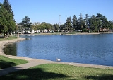
, a lake surrounded by lush greenery and sidewalks. It is bounded by 9th Street to the south, B Street to the east, 14th Street to the north and D Street to the west.
Ellis Lake was once an unsightly swamp. It was not until 1924 that the Women's Improvement Club of Marysville commissioned John McLaren
, famed designer of the Golden Gate Park
in San Francisco, to turn the swamp into a "beautiful lake". The project was completed in 1939. It was recently renovated, thanks in part to the current mayor, Bill D. Harris, Sr.
On October 20, 2002, a car was found at the bottom of the lake, in seven feet of water. Inside the car was the skeletal body of Mary Jane Gooding. The Marysville Police Department believes that Mary Jane Gooding accidentally drove her husband's car into the lake on October 10, 1981. Her children thought she was victim of foul play; however, the Marysville Police Department maintains that there is no evidence to support that a crime was committed.
The lake, named for Marysville citizen W. T. Ellis, Jr., offers a pleasant walk, picnic areas, fishing and pedal boats. For decades, Ellis Lake hosted a 4th of July
celebration every year, featuring power boat and cardboard boat races. Youths built boats out of cardboard and duct tape, then tried to cross the lake without sinking. An annual fireworks display was canceled in 2004 after a young girl lost part of her leg due to a rogue firework shot from the island in the center of the lake into the gathered crowd. That year they had twice as many fireworks than usual, which made shooting the fireworks more difficult and dangerous. The lawsuit finally closed 11 months later when the California Department of Forestry & Fire Protection released a report stating that mortar shells burst low into the crowd onto the other side of the lake from Gazebo Island.
In October 2007, the water fountain and lighting display was renovated and upgraded. The lights feature 37 colors and are viewable year round from 8 pm to midnight. This renovation was made possible by the combined efforts of a group of local citizens who have formed a group called Help Ellis Lake Prosper (H.E.L.P.).
County seat
A county seat is an administrative center, or seat of government, for a county or civil parish. The term is primarily used in the United States....
of Yuba County
Yuba County, California
Yuba County is a county located in the U.S. state of California's Central Valley, north of Sacramento, along the Feather River. As of the 2010 census, its population was 72,155. The county seat is Marysville. Yuba County is part of the Greater Sacramento area.-History:Yuba County was one of the...
, California
California
California is a state located on the West Coast of the United States. It is by far the most populous U.S. state, and the third-largest by land area...
, United States
United States
The United States of America is a federal constitutional republic comprising fifty states and a federal district...
. The population was 12,072 at the 2010 census, down from 12,268 at the 2000 census. It is included in the Yuba City Metropolitan Statistical Area, often referred to as the Yuba-Sutter Area
Yuba-Sutter Area
The Yuba-Sutter Area is a smaller metropolitan community including Yuba and Sutter Counties in Northern California's Central Valley within the Greater Sacramento area. The official name given by the U.S...
after the two counties, Yuba and Sutter. The metropolitan statistical area is part of the Greater Sacramento
Sacramento metropolitan area
The Greater Sacramento area, or officially Sacramento–Arden Arcade–Yuba City, CA-NV Combined Statistical Area, is a combined statistical area consisting of several metropolitan statistical areas and seven counties in Northern California and one in Western Nevada. These are Sacramento, Yolo, El...
area.
History
In 1842, John SutterJohn Sutter
Johann Augus Sutter was a Swiss pioneer of California known for his association with the California Gold Rush by the discovery of gold by James W. Marshall and the mill making team at Sutter's Mill, and for establishing Sutter's Fort in the area that would eventually become Sacramento, the...
leased part of his Rancho New Helvetia land to Theodore Cordua, a native of Mecklenburg
Mecklenburg
Mecklenburg is a historical region in northern Germany comprising the western and larger part of the federal-state Mecklenburg-Vorpommern...
in Germany, who raised livestock and, in 1843, built a home and trading post he called New Mecklenburg. The trading post and home was situated at what would later become the southern end of 'D' Street, Marysville's main street
Main Street
Main Street is the metonym for a generic street name of the primary retail street of a village, town, or small city in many parts of the world...
. In 1844, the Mexican government granted Cordua his own land grant, Rancho Honcut
Rancho Honcut
Rancho Honcut was a Mexican land grant in present day Yuba County, California given in 1844 by Governor Manuel Micheltorena to Theodore Cordua. The rancho is named after Honcut Creek which bounded the grant on the north...
.
In 1848, a former employee of Cordua, Charles Covillaud, discovered riches in the gold fields and bought half of the Cordua ranch. Then, in January 1849, Michael C. Nye and William Foster Nye
William Foster Nye
William Foster Nye was the businessman that started Nye Lubricants in 1844.-Biography:He was born in 1824....
, brothers-in-law to Covillaud's wife, Mary Murphy, bought the other half of the Cordua ranch. They later sold their interest to Covillaud. In October of the same year, Covillaud sold most of the ranch to Jose Ramirez, John Sampson, and Theodore Sicard. In the days of the Gold Rush
California Gold Rush
The California Gold Rush began on January 24, 1848, when gold was found by James W. Marshall at Sutter's Mill in Coloma, California. The first to hear confirmed information of the gold rush were the people in Oregon, the Sandwich Islands , and Latin America, who were the first to start flocking to...
, the ranch was a stopping point for riverboats from Sacramento and San Francisco that carried miners on their way to the digging grounds. A sign on the roadside as one enters Marysville still carries the slogan: "Gateway to The Gold Fields."
In 1850, Covillaud, Ramirez, Sampson, and Sicard hired Augustus Le Plongeon
Augustus Le Plongeon
Augustus Le Plongeon was a photographer and antiquarian who studied the pre-Columbian ruins of America, particularly those of the Maya civilization on the northern Yucatán Peninsula. While his writings contain many eccentric notions that were discredited by later researchers, Le Plongeon left a...
, a French surveyor, to create a plan for a town called Jubaville, later called Yubaville. Stephen J. Field, a newly relocated attorney, purchased 65 lots of land and drew up proper deeds for land being sold. Then, after just three days in the mining camp, he accepted the nomination to run for alcalde
Alcalde
Alcalde , or Alcalde ordinario, is the traditional Spanish municipal magistrate, who had both judicial and administrative functions. An alcalde was, in the absence of a corregidor, the presiding officer of the Castilian cabildo and judge of first instance of a town...
, a Mexican official, which combined the duties of a mayor and justice of the peace, in a new government that was being formed. On January 18, 1850, Field defeated his rival, who had been in town just six days, and a town council was elected. That night, the townsfolk decided to name the new town Marysville after Charles Covillaud's wife, Mary Murphy Covillaud, one of the surviving members of the Donner Party
Donner Party
The Donner Party was a group of American pioneers who set out for California in a wagon train. Delayed by a series of mishaps, they spent the winter of 1846–47 snowbound in the Sierra Nevada...
. After Marysville was incorporated by the new California Legislature, the first mayor was elected in 1851. Field went on to become one of the longest sitting members of the United States Supreme Court.
A post office was established at Marysville in 1851. By 1853, the tent city
Tent City
A tent city is a temporary housing facility made using tents. Informal tent cities may be set up without authorization by homeless people or protesters. As well, state governments or military organizations set up tent cities to house refugees, evacuees, or soldiers...
had been replaced by brick buildings. In addition to the brick merchant buildings, Marysville had developed mills, iron works, factories, machine shops, schools, churches and two daily newspapers. The population was almost 10,000. By 1857, Marysville was a prospering city; in fact, it was one of the largest cities in California, due to strategic location during the Gold Rush. Over $10 million in gold was shipped from the banks in Marysville to the U.S. Mint in San Francisco. The city's founders imagined Marysville becoming "The New York of the Pacific."
However, because of the hydraulic mining
Hydraulic mining
Hydraulic mining, or hydraulicking, is a form of mining that uses high-pressure jets of water to dislodge rock material or move sediment. In the placer mining of gold or tin, the resulting water-sediment slurry is directed through sluice boxes to remove the gold.-Precursor - ground...
on the Yuba River above Marysville, sediment raised the riverbeds of both the Feather and the Yuba Rivers and made Marysville vulnerable to flooding during winter storms and spring run-offs. The city built a levee system that is still maintained today. The levee system sealed the city off and has made additional city growth virtually impossible; as such the population has not increased much since their construction. Marysville has only flooded 3 times since 1875, but the town is now known as "California's Oldest Little City." Also, the newly raised riverbeds made the Feather River more and more difficult to navigate and soon the riverboats could not make the trip to Marysville.
Marysville was home to a significant Chinese American
Chinese American
Chinese Americans represent Americans of Chinese descent. Chinese Americans constitute one group of overseas Chinese and also a subgroup of East Asian Americans, which is further a subgroup of Asian Americans...
community in the 1860s, but it violently drove all its Chinese American residents out of town in February 1886. The Chinese American population has not recovered since.
There was also an active Jewish merchant community in Marysville from the Gold Rush era through the early years of the twentieth century. Nathan Schneider established Schneider's Clothing in 1862, it was advertised as "the Home of Values", and it existed until the late 1980s. Isaac and Simon Glazier ran the Old Corner Cigar Store from 1851 to 1862, when they moved to San Francisco. J.H. Marcuse founded the Western and Palace Cigar Store. Philip Brown advertised himself as "Marysville's leading tailor, pants made to order from $4.00 up and P. Brown's specialty, White Labor Overall." Union Lumber, established in 1852 by W.K. Hudson and Samuel Harryman, was later purchased by bookkeeper H.J. Cheim, and is still owned by the Cheim family.
In 2010, the Marysville City Council made a controversial decision to sell a portion of Washington Square Park for development of a commercial shopping center, part of an effort to increase tax revenue. This came after the city won a costly legal battle brought on by the Citizens to Preserve Marysville's Parks, a group of citizens opposed to development in the city's green spaces. Subsequently, a mitigation measure to offset the loss of city green space has drawn criticism for using city property which is technically within city limits, but fall outside the city's leevee ring.
Historic sites
The National Register list the following 9 Historic sites and 1 Historic district as cultural resources worthy of preservation.Bok Kai Temple
Bok Kai Temple
The Bok Kai Temple is a traditional Chinese temple located at the corner of D and First Streets in the city of Marysville, California, and served as the center of what was a bustling Chinatown .-History:Five years after the first contingent of Chinese arrived in California to work the...
,
Decker-Jewett Bank,
Ellis Building,
Forbes House,
Hart Building,
Warren P. Miller House: Also known as the "Mary Aaron Museum",
Packard Library,
Jose Manuel Ramirez House: Also known as "The W.T. Ellis House" or "The Castle",
US Post Office - Marysville Main,
Marysville Historic Commercial District.
Other sites of historic interest include homes designed by Julia Morgan
Julia Morgan
Julia Morgan was an American architect. The architect of over 700 buildings in California, she is best known for her work on Hearst Castle in San Simeon, California...
, Hotel Marysville, and the State Theater.
Geography
Marysville is located at 39°08′45"N 121°35′29"W.According to the United States Census Bureau
United States Census Bureau
The United States Census Bureau is the government agency that is responsible for the United States Census. It also gathers other national demographic and economic data...
, the city has a total area of 3.6 square miles (9.3 km²), of which, 3.5 square miles (9.1 km²) of it is land and 0.1 square mile (0.258998811 km²) of it (3.36%) is water.
Flooding has been a major concern for the city for many years.
Marysville is 40 miles north of Sacramento and located in the Sacramento Valley
Sacramento Valley
The Sacramento Valley is the portion of the California Central Valley that lies to the north of the San Joaquin-Sacramento Delta in the U.S. state of California. It encompasses all or parts of ten counties.-Geography:...
. The city is bordered on the south and east by the Yuba River
Yuba River
The Yuba River is a tributary of the Feather River in the Sacramento Valley of the U.S. state of California. It is one of the Feather's most important branches, providing about a third of its flow. The main stem of the river is about long, and its headwaters are split into North, Middle and South...
and the west by the Feather River
Feather River
The Feather River is the principal tributary of the Sacramento River, in the Sacramento Valley of Northern California. The river's main stem is about long. Its length to its most distant headwater tributary is about . Its drainage basin is about...
, with the two rivers converging just southwest of the city. In years of significant snow runoff from the nearby Sierra Nevada mountains or heavy rain from winter storms, these two rivers pose a serious flooding risk to the city.
Climate
Marysville has a Mediterranean ClimateMediterranean climate
A Mediterranean climate is the climate typical of most of the lands in the Mediterranean Basin, and is a particular variety of subtropical climate...
, which is mild, wet, winters and hot, dry, summers. January is usually the wettest month. July is the driest and hottest. The wet season starts from mid-October and ends in mid-April when Yuba City sees frequent rain and is usually under the tule fog
Tule fog
Tule fog is a thick ground fog that settles in the San Joaquin Valley and Sacramento Valley areas of California's Great Central Valley. Tule fog forms during the late fall and winter after the first significant rainfall. The official time frame for tule fog to form is from November 1 to March 31...
. Heavy rain, especially during El Niño or too much mountain snow from winter storms can cause major flooding in the spring. Snow is rare in the valley, but cold waves from the north bring some light snow and ice. Spring is wet in the beginning but becomes dryer and warmer as summer months approach. April is the wettest spring month. May has some rain, but usually from thunderstorms than winter storms. Spring orchards and fields become filled with flowers and tree blossoms during Spring. June-to-September is the dry and hot season. Rain usually doesn't fall at all, but from rare southwest monsoon thunderstorms. July and August are the hottest months when temperatures reach the upper 90's. Heat waves usually occur from June through September. The hottest months are July and August. The delta breeze, which comes from the Bay Area on summer nights, helps cool temperatures and add humidity. At times the delta breeze is strong enough to bring coastal fog inland to the Sacramento Valley
Sacramento Valley
The Sacramento Valley is the portion of the California Central Valley that lies to the north of the San Joaquin-Sacramento Delta in the U.S. state of California. It encompasses all or parts of ten counties.-Geography:...
. Autumn starts out warm but begins to become cooler, wetter, and foggier. From September-to-mid-October temperatures begin to cool down rapidly bringing rain and fog. Rain and fog become more persistent from mid-October into November.
2010
The 2010 United States Census reported that Marysville had a population of 12,072. The population densityPopulation density
Population density is a measurement of population per unit area or unit volume. It is frequently applied to living organisms, and particularly to humans...
was 3,367.9 people per square mile (1,300.3/km²). The racial makeup of Marysville was 8,576 (71.0%) White, 522 (4.3%) African American, 298 (2.5%) Native American, 498 (4.1%) Asian, 38 (0.3%) Pacific Islander, 1,247 (10.3%) from other races
Race (United States Census)
Race and ethnicity in the United States Census, as defined by the Federal Office of Management and Budget and the United States Census Bureau, are self-identification data items in which residents choose the race or races with which they most closely identify, and indicate whether or not they are...
, and 893 (7.4%) from two or more races. Hispanic or Latino of any race were 2,920 persons (24.2%).
The Census reported that 11,402 people (94.4% of the population) lived in households, 145 (1.2%) lived in non-institutionalized group quarters, and 525 (4.3%) were institutionalized.
There were 4,668 households, out of which 1,571 (33.7%) had children under the age of 18 living in them, 1,551 (33.2%) were opposite-sex married couples
Marriage
Marriage is a social union or legal contract between people that creates kinship. It is an institution in which interpersonal relationships, usually intimate and sexual, are acknowledged in a variety of ways, depending on the culture or subculture in which it is found...
living together, 836 (17.9%) had a female householder with no husband present, 318 (6.8%) had a male householder with no wife present. There were 453 (9.7%) unmarried opposite-sex partnerships
POSSLQ
POSSLQ is an abbreviation for "Persons of Opposite Sex Sharing Living Quarters," a term coined in the late 1970s by the United States Census Bureau as part of an effort to more accurately gauge the prevalence of cohabitation in American households....
, and 35 (0.7%) same-sex married couples or partnerships. 1,606 households (34.4%) were made up of individuals and 579 (12.4%) had someone living alone who was 65 years of age or older. The average household size was 2.44. There were 2,705 families
Family (U.S. Census)
A family or family household is defined by the United States Census Bureau for statistical purposes as "a householder and one or more other people related to the householder by birth, marriage, or adoption. They do not include same-sex married couples even if the marriage was performed in a state...
(57.9% of all households); the average family size was 3.14.
The population was spread out with 3,032 people (25.1%) under the age of 18, 1,569 people (13.0%) aged 18 to 24, 3,158 people (26.2%) aged 25 to 44, 2,860 people (23.7%) aged 45 to 64, and 1,453 people (12.0%) who were 65 years of age or older. The median age was 32.5 years. For every 100 females there were 99.6 males. For every 100 females age 18 and over, there were 98.3 males.
There were 5,196 housing units at an average density of 1,449.6 per square mile (559.7/km²), of which 1,828 (39.2%) were owner-occupied, and 2,840 (60.8%) were occupied by renters. The homeowner vacancy rate was 2.7%; the rental vacancy rate was 10.2%. 4,571 people (37.9% of the population) lived in owner-occupied housing units and 6,831 people (56.6%) lived in rental housing units.
2000
As of the censusCensus
A census is the procedure of systematically acquiring and recording information about the members of a given population. It is a regularly occurring and official count of a particular population. The term is used mostly in connection with national population and housing censuses; other common...
of 2000, there were 12,268 people, 4,687 households, and 2,826 families residing in the city. The population density
Population density
Population density is a measurement of population per unit area or unit volume. It is frequently applied to living organisms, and particularly to humans...
was 3,501.1 people per square mile (1,353.3/km²). There were 4,999 housing units at an average density of 1,426.6 per square mile (551.5/km²). The racial makeup of the city was 71.0% White, 4.8% African American, 2.3% Native American, 6.0% Asian (including many Hmong people
Hmong people
The Hmong , are an Asian ethnic group from the mountainous regions of China, Vietnam, Laos, and Thailand. Hmong are also one of the sub-groups of the Miao ethnicity in southern China...
), 0.2% Pacific Islander, 10.1% from other races
Race (United States Census)
Race and ethnicity in the United States Census, as defined by the Federal Office of Management and Budget and the United States Census Bureau, are self-identification data items in which residents choose the race or races with which they most closely identify, and indicate whether or not they are...
, and 5.7% from two or more races. Hispanic or Latino of any race were 17.5% of the population.
There were 4,687 households out of which 32.4% had children under the age of 18 living with them, 38.8% were married couples
Marriage
Marriage is a social union or legal contract between people that creates kinship. It is an institution in which interpersonal relationships, usually intimate and sexual, are acknowledged in a variety of ways, depending on the culture or subculture in which it is found...
living together, 15.7% had a female householder with no husband present, and 39.7% were non-families. 31.5% of all households were made up of individuals and 11.3% had someone living alone who was 65 years of age or older. The average household size was 2.49 and the average family size was 3.14.
The population was spread out with 27.5% under the age of 18, 11.7% from 18 to 24, 29.2% from 25 to 44, 18.4% from 45 to 64, and 13.1% who were 65 years of age or older. The median age was 32 years. For every 100 females there were 99.6 males. For every 100 females age 18 and over, there were 96.3 males.
The median income
Income
Income is the consumption and savings opportunity gained by an entity within a specified time frame, which is generally expressed in monetary terms. However, for households and individuals, "income is the sum of all the wages, salaries, profits, interests payments, rents and other forms of earnings...
for a household in the city was $28,494, and the median income for a family was $33,474. Males had a median income of $27,630 versus $20,240 for females. The per capita income
Per capita income
Per capita income or income per person is a measure of mean income within an economic aggregate, such as a country or city. It is calculated by taking a measure of all sources of income in the aggregate and dividing it by the total population...
for the city was $15,315. About 15.2% of families and 18.9% of the population were below the poverty line, including 26.9% of those under age 18 and 7.4% of those age 65 or over.
Politics
In the state legislatureCalifornia State Legislature
The California State Legislature is the state legislature of the U.S. state of California. It is a bicameral body consisting of the lower house, the California State Assembly, with 80 members, and the upper house, the California State Senate, with 40 members...
Marysville is located in the 4th Senate
California State Senate
The California State Senate is the upper house of the California State Legislature. There are 40 state senators. The state legislature meets in the California State Capitol in Sacramento. The Lieutenant Governor is the ex officio President of the Senate and may break a tied vote...
District, represented by Republican
Republican Party (United States)
The Republican Party is one of the two major contemporary political parties in the United States, along with the Democratic Party. Founded by anti-slavery expansion activists in 1854, it is often called the GOP . The party's platform generally reflects American conservatism in the U.S...
Doug LaMalfa
Doug LaMalfa
Doug LaMalfa is an American politician currently serving in the California State Senate. He is a Republican representing the 4th district, encompassing Del Norte, Siskiyou, Shasta, Trinity, Tehama, Butte, Glenn, Colusa, Sutter, and Yuba counties, as well as parts of Nevada and Placer counties...
, and in the 3rd Assembly
California State Assembly
The California State Assembly is the lower house of the California State Legislature. There are 80 members in the Assembly, representing an approximately equal number of constituents, with each district having a population of at least 420,000...
District, represented by Republican Dan Logue. Federally, Marysville is located in California's 2nd congressional district
California's 2nd congressional district
California's 2nd congressional district is a congressional district located in the U.S. state of California. The district contains much of the far northern part of the state, north of Sacramento. It is the largest district by area in California...
, which has a Cook PVI
Cook Partisan Voting Index
The Cook Partisan Voting Index , sometimes referred to as simply the Partisan Voting Index , is a measurement of how strongly an American congressional district or state leans toward one political party compared to the nation as a whole...
of R +13 and is represented by Republican Wally Herger
Wally Herger
Walter William "Wally" Herger, Jr. , American politician, has been a Republican member of the United States House of Representatives since 1987, representing the California's 2nd congressional district. The second district is physically large...
. As of December 2010 the city of Marysville is represented by Mayor Bill Harris and council members Jim Kitchen, Christina Billeci, Ricky Samayoa and Dale Whitmore. City council meetings are held on the first and third Tuesday's of the month at 7 PM in city hall. City council members serve four year terms.
Education
Marysville is served by Marysville Joint Unified School District for its public school system. It has four high schools: Marysville HighMarysville High School (California)
Marysville High School is a public school located in Marysville, California, USA within the Yuba City Metropolitan Statistical Area. The school mascot is the Indians and the school colors are orange and black...
, Lindhurst High School, Marysville Charter Academy for the Arts, and Abraham Lincoln Home School.
The city is home to the county's only brick and mortar library of the Yuba County Library
Yuba County Library
Yuba County Library is a the library service for 70,000 people of Yuba County, California.-History:The library currently has one branch in Marysville. Yuba County Library also has a book mobile that travels to different areas to improve access to books. The library is planning on adding a GoLibrary...
system.
Media
The Appeal-DemocratAppeal-Democrat
The Appeal-Democrat is a daily broadsheet newspaper printed in Marysville, California, in the United States. It has an estimated circulation of 23,000 copies a day, primarily in Yuba and Sutter counties...
is a newspaper located in Marysville, and serves the Yuba-Sutter Area. The Territorial Dispatch is small local free paper. One zine, Wednesday Will Be, is also printed and distributed locally. The Sacramento Bee is also widely sold in the city. MySYtv.com provides television coverage of local events in the area.
Transportation
Marysville is served by two highways. California State Route 20 is the major east-west route, running to Nevada CityNevada City, California
-2010:The 2010 United States Census reported that Nevada City had a population of 3,068. The population density was 1,399.7 people per square mile . The racial makeup of Nevada City was 2,837 White, 26 African American, 28 Native American, 46 Asian, 0 Pacific Islander, 40 from other races,...
to the east, and towards Yuba City
Yuba City, California
Yuba City is a Northern California city, founded in 1849. It is the county seat of Sutter County, California, United States. The population was 64,925 at the 2010 census....
and Williams
Williams, California
Williams is a city in Colusa County, California, United States. The population was 5,123 at the 2010 census, up from 3,670 at the 2000 census. It is a traveler's city with many fast food restaurants, motels, and gas stations...
to the west. California State Route 70
California State Route 70
State Route 70 is a state highway in the U.S. state of California. Connecting Sacramento with U.S. Route 395 near Beckwourth Pass via the Feather River Canyon, it was formerly known as U.S. Route 40 Alternate, crossing the Sierra Nevada at a lower elevation than Donner Pass on U.S. Route 40...
travels south towards Sacramento
Sacramento, California
Sacramento is the capital city of the U.S. state of California and the county seat of Sacramento County. It is located at the confluence of the Sacramento River and the American River in the northern portion of California's expansive Central Valley. With a population of 466,488 at the 2010 census,...
, and north to Quincy
Quincy, California
Quincy is a census-designated place and the county seat of Plumas County, California. The population was 1,728 at the 2010 census, down from 1,879 at the 2000 census. Quincy is named after the city of Quincy, Illinois...
.
Yuba County Airport
Yuba County Airport
Yuba County Airport is a public airport located three miles southeast of Marysville, serving Yuba County, California, USA. The airport has two runways and is mostly used for general aviation.- Facilities :Yuba County Airport has two runways:...
is located three miles southeast of Marysville. It has two runway
Runway
According to ICAO a runway is a "defined rectangular area on a land aerodrome prepared for the landing and take-off of aircraft." Runways may be a man-made surface or a natural surface .- Orientation and dimensions :Runways are named by a number between 01 and 36, which is generally one tenth...
s and is mostly used for general aviation
General aviation
General aviation is one of the two categories of civil aviation. It refers to all flights other than military and scheduled airline and regular cargo flights, both private and commercial. General aviation flights range from gliders and powered parachutes to large, non-scheduled cargo jet flights...
.
Bus service is provided by Yuba Sutter Transit.
Parks
Marysville has 15 parks and they are classified as either community, neighborhood and passive.East Lake
East lake park is located between 14th and 16th streets on Yuba street and sports picnic facilities in a natural setting.Bryant Field
City owned baseball stadium and home of the Marysville Gold Sox Baseball team. Facility provides seating for 3000 people and is available for rental either from the Gold Sox during the season or the city in the off season.Beckwourth Riverfront Park Complex
The city’s Beckwourth Riverfront Park is a large complex located on Bizz Johnson Drive adjacent to the Feather River. Amenities include a OHV MotoCross Course, Soccer Fields used by the Yuba Sutter Youth Soccer League, a nature area and Feather River Pavilion, a picnicking area known as Lion’s Grove, a boat ramp, softball fields, and a BMX track. Most of these facilities are available for rental. Beckwourth Riverfront Park also hosts the annual Marysville Stampede, a rodeo event featuring Cotton Rosser and his crew.Gavin Park
Located at Johnson Avenue and Val Drive, this park has picnic tables, benches, play equipment and a large open play area.Miner Park
Located between Swezy and Sampson Street and East 14th and East 15th, this is one of the largest neighborhood parks. The amenities include play equipment, tot equipment, benches, a picnic table and basketball hoops, as well as a large open play area.Motor Park
Located at 14th and G streets, this park has play equipment, tot equipment, benches, picnic tables, a full court basketball pad and a large open play area.Steven J. Field(circle) Park
This small circular shaped park is located on Rideout Way between Greeley Drive and Boulton Way. This park has play equipment, tot equipment, benches, picnic tables and an open play area.Triplett Park
Located at Rideout Way and Covillaud Street, this park has picnic tables, benches, play equipment, tot equipment, and a large open play area.Veterans Park
Formerly known as Napoleon Square, the name of this park was changed upon the completion of the Veterans Memorial in 2000. The amenities at this park located on 5th Street between G and H streets include play equipment, benches and picnic tables.Yuba Park
Located at Yuba Street and East 10th Street, the amenities at this park include play equipment, picnic facilities and a large open play area.Basin Park
Located on Hall Street between East 17th and Harris Street in East Marysville, this seasonal park is used for storm drainage storage during the rainy season. When the area is dry, the basin can be used for sports practices.3rd and D Street Mini Park
Conveniently located in historic downtown Marysville there are benches available for taking a break while shopping.Plaza Park
Located at 1st and D Street near the Bok Kai TempleBok Kai Temple
The Bok Kai Temple is a traditional Chinese temple located at the corner of D and First Streets in the city of Marysville, California, and served as the center of what was a bustling Chinatown .-History:Five years after the first contingent of Chinese arrived in California to work the...
, there are benches and picnic tables available.
Washington Park
The four corners at 10th and E Street were historically called Washington Square. Picnic tables and large open areas are available for outdoor dining and recreation.The Mary Aaron Memorial Museum
Built in 1855, the Gothic revival residence was one of the first brick structures in the area. Home to the Aaron Family until 1935, it is now held in trust by the city of Marysville and Yuba County. The forgotten lives of local residents are documented by photographs, costumes and other furnishings in the changing exhibits including many of the Chinese community who helped establish Marysville. Admission to the museum is free of charge.Bok Kai Temple (北溪廟)
The Bok Kai TempleBok Kai Temple
The Bok Kai Temple is a traditional Chinese temple located at the corner of D and First Streets in the city of Marysville, California, and served as the center of what was a bustling Chinatown .-History:Five years after the first contingent of Chinese arrived in California to work the...
was erected in 1854, and rebuilt in 1880, by the Chinese for the worship of their gods. The most important worshiped there was Bok Eye
Xuan Wu (god)
Xuan Wu , posthumously known as The Dark/Mysterious Heavenly Upper Emperor , as well as True Warrior Grand Emperor , and commonly known as The Northern Emperor or Emperor Lord or Teh Kong in Hokkien...
, the god of water who had the power to control the rains. The temple remains a focus of the present Marysville Chinese community, who have dedicated themselves to preserving it.
Bok Kai Festival and Parade (北溪慶會)
Marysville annually celebrates the Chinese New YearChinese New Year
Chinese New Year – often called Chinese Lunar New Year although it actually is lunisolar – is the most important of the traditional Chinese holidays. It is an all East and South-East-Asia celebration...
and the god Bok Eye with a festival. The Bok Kai parade has been produced each year for more than 130 years and is the oldest continuing parade in California. Because the festival celebrates Bok Eye according to the Chinese lunar calendar, the date of the parade is different each year. Marching bands, fire trucks, antique cars, floats, and dance groups walk the streets of historic downtown. Over 15,000 spectators each year come to watch the parade's greatest asset, a dragon 175 feet (53.3 m) long.
The festival concludes with the lighting of "bombs," which are made by hand under special permit from the State of California. Bomb Day is formally called Yee Yuet Yee by the Chinese community. The bombs are fired in a roped arena where young Chinese scramble for “good fortune” rings which are shot into the air by the bursting bombs, traditionally bringing good fortune to the holder throughout the year.
Ellis Lake
The most memorable centerpiece of Marysville is Ellis LakeEllis Lake
Located in Marysville, California, Ellis Lake has been the most memorable centerpeice of in the City of Marysville since the 1930s. It is a sparkling man-made lake surrounded by lush greenery and sidewalks with flocks of geese and a variety of other birds...
, a lake surrounded by lush greenery and sidewalks. It is bounded by 9th Street to the south, B Street to the east, 14th Street to the north and D Street to the west.
Ellis Lake was once an unsightly swamp. It was not until 1924 that the Women's Improvement Club of Marysville commissioned John McLaren
John McLaren
John McLaren is the name of:*John McLaren , built Golden Gate Park*John McLaren, Lord McLaren , Scottish Liberal MP and judge*John McLaren , Australian cricketer...
, famed designer of the Golden Gate Park
Golden Gate Park
Golden Gate Park, located in San Francisco, California, is a large urban park consisting of of public grounds. Configured as a rectangle, it is similar in shape but 20% larger than Central Park in New York, to which it is often compared. It is over three miles long east to west, and about half a...
in San Francisco, to turn the swamp into a "beautiful lake". The project was completed in 1939. It was recently renovated, thanks in part to the current mayor, Bill D. Harris, Sr.
On October 20, 2002, a car was found at the bottom of the lake, in seven feet of water. Inside the car was the skeletal body of Mary Jane Gooding. The Marysville Police Department believes that Mary Jane Gooding accidentally drove her husband's car into the lake on October 10, 1981. Her children thought she was victim of foul play; however, the Marysville Police Department maintains that there is no evidence to support that a crime was committed.
The lake, named for Marysville citizen W. T. Ellis, Jr., offers a pleasant walk, picnic areas, fishing and pedal boats. For decades, Ellis Lake hosted a 4th of July
Independence Day (United States)
Independence Day, commonly known as the Fourth of July, is a federal holiday in the United States commemorating the adoption of the Declaration of Independence on July 4, 1776, declaring independence from the Kingdom of Great Britain...
celebration every year, featuring power boat and cardboard boat races. Youths built boats out of cardboard and duct tape, then tried to cross the lake without sinking. An annual fireworks display was canceled in 2004 after a young girl lost part of her leg due to a rogue firework shot from the island in the center of the lake into the gathered crowd. That year they had twice as many fireworks than usual, which made shooting the fireworks more difficult and dangerous. The lawsuit finally closed 11 months later when the California Department of Forestry & Fire Protection released a report stating that mortar shells burst low into the crowd onto the other side of the lake from Gazebo Island.
In October 2007, the water fountain and lighting display was renovated and upgraded. The lights feature 37 colors and are viewable year round from 8 pm to midnight. This renovation was made possible by the combined efforts of a group of local citizens who have formed a group called Help Ellis Lake Prosper (H.E.L.P.).
Appeal-Democrat Park
Appeal-Democrat Park is home of the Marysville Gold Sox's a colliegiate wood-bat baseball club.External links
- Marysville City Website
- http://www.beale.af.mil/ Beale Air Force BaseBeale Air Force BaseBeale Air Force Base is a United States Air Force base located approximately east of Marysville, California. Originally known as Camp Beale....
Website - Marysville on the Yuba-Sutter local wiki
- Bok Kai Temple website
- Bok Kai Festival website
- Mary Aaron Museum