
Sacramento Regional Transit District
Encyclopedia
The Sacramento Regional Transit District, commonly referred to as RT, is the agency responsible for public transport
ation in the Sacramento, California
area. It was established on April 1, 1973, as a result of the acquisition of the Sacramento Transit Authority. Along with about 60 bus routes, RT operates a large light rail
system and connecting bus service in the Sacramento area, covering 418 sq mi (1,082.6 km²). It is currently the ninth busiest light rail system in the United States.
In addition to the city of Sacramento, RT serves much of the northern portion of Sacramento County
which includes the incorporated cities of Citrus Heights
and Rancho Cordova
. The unincorporated areas of Sacramento County under the RT service area include Arden Arcade, Carmichael
, Fair Oaks
, Florin
, Gold River
, North Highlands
, Orangevale
, Rio Linda
and Rosemont
. The system formerly provided express bus service between Downtown Sacramento
and Elk Grove
until the mid-2000's when that city took over bus operations under the newly created E-tran
.
Over the next decade RT continued to expand bus service to the growing Sacramento Region while a cooperative effort emerged among city, county and state government officials to develop a light rail system. In 1987 the 18.3 miles (29.5 km) light rail “starter line” opened, linking the northeastern (Interstate 80) and eastern (Highway 50) corridors with Downtown Sacramento. As light rail ridership increased, RT continued to expand the light rail system. RT completed its first light rail expansion along the Highway 50 corridor in September 1998 with the opening of the Mather Field/Mills Station. Five years later (September 2003) RT opened the first phase of the South Line, a 6.3 miles (10.1 km) extension to South Sacramento. In June 2004, light rail was extended from the Mather Field/Mills station to Sunrise Boulevard, and on October 15, 2005 a 7.4 miles (11.9 km) extension from the Sunrise station to the city of Folsom was opened.
In December 2006, the final leg of the Amtrak/Folsom project was extended .7 miles (11.3 km) to the downtown Sacramento Valley Station, connecting light rail with Amtrak inter-city and Capitol Corridor services as well as local and commuter buses. Within the next several years, RT plans to extend light rail beyond Meadowview in South Sacramento to Cosumnes River College and north to Sacramento International Airport. RT currently operates 97 bus routes in a 418 square miles (1,082.6 km²) service area.
RT is governed by an eleven-member Board of Directors composed of members of the Sacramento, Elk Grove, Citrus Heights, Rancho Cordova, and Folsom City Councils as well as members of the Sacramento County Board of Supervisors. The fiscal year 2006 operating budget is $148.54 million, with a capital budget of $15.4 million.
RT employs a work force of approximately 1,163 people, 80 percent of whom are dedicated to operations and maintenance of the bus and light rail systems. RT operates three maintenance and operations facilities – one for buses at 29th and N Streets, one for the Community Bus Service at McClellan Park, and one for the light rail system at 2700 Academy Way in North Sacramento.
07.501 (VII) and Orion VII Next Generation buses powered by compressed natural gas
.
The RT system operates 65 bus routes, as of 2010, with service between 5:00 a.m. and 9:00 p.m. daily. Frequencies range between every 15 and 80 minutes (some express buses run only a few times a day).
Since light rail has opened, buses have generally acted as feeders to light rail routes.
The RT system does not provide service to Sacramento International Airport
. Service between downtown Sacramento and the airport is instead provided on an hourly basis by the Yolobus
system.
A vehicles, which have been in use since the light rail's inception and more modern CAF
trains delivered in 2003.
Before the June 2010 budget cuts, RT light rail formerly operated from 4:30 a.m. to 1 a.m. daily with 15 minute headways during the day. (Only the RT bus service division has never operated beyond midnight, even the busiest routes.) After the budget cuts took place, it was curtailed to operate from 4:30 a.m. to 10 p.m. daily, with service every 15 minutes in the day Monday through Friday and every 30 minutes on weekends and every night. The light rail system, with 44,400 daily boardings, is the tenth busiest in the United States.
The creation and maintenance of the light-rail system is pushed by the advocacy group Friends of Light Rail and Transit.
via the neighborhood of Natomas
. A planned extension to Roseville
, once a top priority, has been on the back burner for years. Extensions to Davis
, Elk Grove
, Woodland
and other locations are shown on the 20-year plan. In December 2007, Regional Transit committed to completing the extension from the Sacramento Valley Station to Richards Blvd by 2010 which would take it through the planned Railyards
project and extend it to the also planned Township 9 development.
service in 1993, which is a door-to-door service for the disabled.
A man was hospitalized April 26, 2010 after he was hit by a light rail while talking on a cell phone.The crash happened near the Iron Point Station in Folsom at about 10 a.m. Investigators said the pedestrian was walking on the tracks and not paying attention to what was coming toward him. The pedestrian on the tracks never looked up at all throughout the entire incident. The operator told investigators that he had spoken to the injured person, and the guy said that he was walking on the tracks because he didn't want to be walking on the roadway while talking on his cell phone. The pedestrian was in serious condition at UC Davis Medical Center. Passengers on the train had an hour delay.
Deputies were called shortly after 9 a.m. on April 27, 2010 to the Zinfandel station. Sheriff's Sgt. Tim Curran said one person shot the victim in the leg and then fled.Investigators said a fight broke out on a light rail train, culminating in a shooting once the train reached the station platform. The alleged shooter was seen running across the parking lot outside a nearby Ross store, Curran said. The victim was expected to survive, authorities said. RT service did not appear to be affected.
On November 11, 2010 a pick up truck ran into the side of a moving Regional Transit Light Rail Train at 10:15 a.m. at Starfire Drive and Folsom Boulevard in Sacramento County. The train was only scratched in the collision. Only one passenger received medical attention for minor injuries; the two people in the truck were not hurt.
A Siemens light rail vehicle on a Gold Line train caught fire and started to smoke on December 23, 2010 at approximately 7:30 a.m. near the College Greens station. A communications issue between the Sacramento Fire Department and the Regional Transit light rail operator occurred when the train began to move from the station where the fire was being doused to the Watt/Manlove station over a mile away. The fire caused service disruptions to Gold Line trains traveling in both directions for up to an hour. The car (#136) was towed out of service to the Regional Transit maintenance facility on Academy Way. The fire was likely caused by an overheated generator and battery located on the bottom of the train.
Public transport
Public transport is a shared passenger transportation service which is available for use by the general public, as distinct from modes such as taxicab, car pooling or hired buses which are not shared by strangers without private arrangement.Public transport modes include buses, trolleybuses, trams...
ation in the Sacramento, California
Sacramento, California
Sacramento is the capital city of the U.S. state of California and the county seat of Sacramento County. It is located at the confluence of the Sacramento River and the American River in the northern portion of California's expansive Central Valley. With a population of 466,488 at the 2010 census,...
area. It was established on April 1, 1973, as a result of the acquisition of the Sacramento Transit Authority. Along with about 60 bus routes, RT operates a large light rail
Light rail
Light rail or light rail transit is a form of urban rail public transportation that generally has a lower capacity and lower speed than heavy rail and metro systems, but higher capacity and higher speed than traditional street-running tram systems...
system and connecting bus service in the Sacramento area, covering 418 sq mi (1,082.6 km²). It is currently the ninth busiest light rail system in the United States.
In addition to the city of Sacramento, RT serves much of the northern portion of Sacramento County
Sacramento County, California
Sacramento County is a county in the U.S. state of California. Its county seat is Sacramento, which is also the state capital. As of 2010 the county had a population of 1,418,788....
which includes the incorporated cities of Citrus Heights
Citrus Heights, California
Citrus Heights is a city in Sacramento County, California, USA. As of the 2010 census, the city had a population of 83,301, down from 85,071 at the 2000 census....
and Rancho Cordova
Rancho Cordova, California
Rancho Cordova is a city in Sacramento County, California, USA, that incorporated in 2003. It is part of the Sacramento Metropolitan Area. The population was 64,776 at the 2010 census. Rancho Cordova is the Sacramento area's largest employment sub-center, with a daily influx of over 45,000...
. The unincorporated areas of Sacramento County under the RT service area include Arden Arcade, Carmichael
Carmichael, California
Carmichael is a census-designated place in Sacramento County, California, United States. It is part of the Sacramento–Arden-Arcade–Roseville Metropolitan Statistical Area. The population was 61,762 at the 2010 census, up from 49,742 at the 2000 census.-Geography and geology:Carmichael...
, Fair Oaks
Fair Oaks, California
Fair Oaks is a census-designated place in Sacramento County, California, United States. It is part of the Sacramento–Arden-Arcade–Roseville Metropolitan Statistical Area. The population was 30,912 at the 2010 census, up from 28,008 at the 2000 census. Fair Oaks's zip code is 95628...
, Florin
Florin, California
Florin is a census-designated place in Sacramento County, California, United States. It is part of the Sacramento–Arden-Arcade–Roseville Metropolitan Statistical Area...
, Gold River
Gold River, California
Gold River is a census-designated place in Sacramento County, California. The population was 7,812 at the 2010 census, down from 8,023 at the 2000 census...
, North Highlands
North Highlands, California
North Highlands is a census-designated place in Sacramento County, California, United States. It is part of the Sacramento–Arden-Arcade–Roseville Metropolitan Statistical Area...
, Orangevale
Orangevale, California
Orangevale is a census-designated place in Sacramento County, California, United States. It is part of the Sacramento–Arden-Arcade–Roseville Metropolitan Statistical Area. The population was 33,960 at the 2010 census, up from 26,705 at the 2000 census. It is located approximately ...
, Rio Linda
Rio Linda, California
Rio Linda is a census-designated place in Sacramento County, California, United States. It is part of the Sacramento–Arden-Arcade–Roseville Metropolitan Statistical Area. As of the 2010 census, the CDP population was 15,106, up from 10,466 at the 2000 census...
and Rosemont
Rosemont, California
Rosemont is a census-designated place in Sacramento County, California, United States. It is part of the Sacramento–Arden-Arcade–Roseville Metropolitan Statistical Area...
. The system formerly provided express bus service between Downtown Sacramento
Downtown Sacramento
Downtown Sacramento is the central business district of the City of Sacramento. Downtown is generally defined as the area south of the American River, east of the Sacramento River, north of Broadway, and west of 16th Street. The central business district is generally defined as north of R Street,...
and Elk Grove
Elk Grove, California
Elk Grove is a city in Sacramento County, California, located just south of the state capital of Sacramento. It is part of the Sacramento–Arden-Arcade–Roseville Metropolitan Statistical Area. As of the 2010 census, the population of the city is 153,015...
until the mid-2000's when that city took over bus operations under the newly created E-tran
E-tran
e-tran is the public transit system for the city of Elk Grove, California and parts of south Sacramento. With currently 20 local routes, it began service on January 2, 2005. Nearby Sacramento RT formerly operated bus service in Elk Grove, but it mostly consisted of express bus routes linking Elk...
.
History
RT began operations on April 1, 1973, with the acquisition of the Sacramento Transit Authority. Later that year RT completed a new maintenance facility and purchased 103 buses.Over the next decade RT continued to expand bus service to the growing Sacramento Region while a cooperative effort emerged among city, county and state government officials to develop a light rail system. In 1987 the 18.3 miles (29.5 km) light rail “starter line” opened, linking the northeastern (Interstate 80) and eastern (Highway 50) corridors with Downtown Sacramento. As light rail ridership increased, RT continued to expand the light rail system. RT completed its first light rail expansion along the Highway 50 corridor in September 1998 with the opening of the Mather Field/Mills Station. Five years later (September 2003) RT opened the first phase of the South Line, a 6.3 miles (10.1 km) extension to South Sacramento. In June 2004, light rail was extended from the Mather Field/Mills station to Sunrise Boulevard, and on October 15, 2005 a 7.4 miles (11.9 km) extension from the Sunrise station to the city of Folsom was opened.
In December 2006, the final leg of the Amtrak/Folsom project was extended .7 miles (11.3 km) to the downtown Sacramento Valley Station, connecting light rail with Amtrak inter-city and Capitol Corridor services as well as local and commuter buses. Within the next several years, RT plans to extend light rail beyond Meadowview in South Sacramento to Cosumnes River College and north to Sacramento International Airport. RT currently operates 97 bus routes in a 418 square miles (1,082.6 km²) service area.
RT is governed by an eleven-member Board of Directors composed of members of the Sacramento, Elk Grove, Citrus Heights, Rancho Cordova, and Folsom City Councils as well as members of the Sacramento County Board of Supervisors. The fiscal year 2006 operating budget is $148.54 million, with a capital budget of $15.4 million.
RT employs a work force of approximately 1,163 people, 80 percent of whom are dedicated to operations and maintenance of the bus and light rail systems. RT operates three maintenance and operations facilities – one for buses at 29th and N Streets, one for the Community Bus Service at McClellan Park, and one for the light rail system at 2700 Academy Way in North Sacramento.
Fares
| Group | Fare Type | Single | Daily Pass | Monthly Pass |
|---|---|---|---|---|
| 19-61 | Basic | $2.50 | $6.00 | $100.00 |
| Student (5-18) | Discount | $1.25 | $3.00 | $50.00 |
| Disabled | Discount | $1.25 | $3.00 | $50.00 |
| Senior 62+ | Discount | $1.25 | $3.00 | $50.00 |
| Super Senior 75+ | Discount | Senior Fare | Senior Fare | $40.00 |
PrePaid Ticket Books
PrePaid tickets are sold in books of ten.| Group | Fare Type | Single | Daily Pass |
|---|---|---|---|
| 19-61 | Basic | $25.00 | $60.00 |
| Senior 62+ | Discount | $12.50 | $30.00 |
| Disabled | Discount | $12.50 | $30.00 |
| Student (5-18) | Discount | $12.50 | $30.00 |
Class Pass
Regional Transit also offers the Class Pass for use during 9am-3:30pm. For any group of ten or more students that are pursuing a high school diploma the cost is $2.50 per student and $5.00 for each adult.Bus service
Since 2004, with the exception of some neighborhood shuttle vans (see #The Neighborhood Ride below), the bus fleet is consisted exclusively of OrionOrion Bus Industries
Orion International, previously Orion Bus Industries and Ontario Bus Industries in Canada and Bus Industries of America in the United States, is a bus manufacturer based in Mississauga, Ontario, Canada and established by the Government of Ontario in 1975...
07.501 (VII) and Orion VII Next Generation buses powered by compressed natural gas
Compressed natural gas
Compressed natural gas is a fossil fuel substitute for gasoline , diesel, or propane/LPG. Although its combustion does produce greenhouse gases, it is a more environmentally clean alternative to those fuels, and it is much safer than other fuels in the event of a spill...
.
The RT system operates 65 bus routes, as of 2010, with service between 5:00 a.m. and 9:00 p.m. daily. Frequencies range between every 15 and 80 minutes (some express buses run only a few times a day).
Since light rail has opened, buses have generally acted as feeders to light rail routes.
The RT system does not provide service to Sacramento International Airport
Sacramento International Airport
Sacramento International Airport is a public airport located 10 miles northwest of the central business district of Sacramento, in Sacramento County, California, USA. It is run by Sacramento County...
. Service between downtown Sacramento and the airport is instead provided on an hourly basis by the Yolobus
Yolobus
Yolobus provides public transportation throughout Yolo County, California and into downtown Sacramento, to western Sacramento County and northeastern Solano County. Yolobus is the only public transit system that provides daily service to the Sacramento International Airport and Cache Creek Casino...
system.
Most popular bus routes
The numbers provided are average weekday boardings.- Route 51 Broadway/Stockton 4,162
- Route 81 Florin/65th 3,338
- Route 1 Greenback 2,921
Transit Centers
| Transit Center | Location | Bike lockers | Transfers |
|---|---|---|---|
| American River College American River College American River College is a California community college located in the southern edge of unincorporated Foothill Farms in Sacramento County, California.... |
Location | No | 1, 82 |
| Arden Fair Mall Arden Fair Mall Arden Fair Mall is a two-level regional shopping mall located on Arden Way in Sacramento, California, USA. It consists of over 165 tenants, encompassing over of retail space. It is anchored by JCPenney, Macy's, Nordstrom and Sears... |
Location | No | 22, 23, 29, 67, 68 |
| Cosumnes River College Cosumnes River College Cosumnes River College is a two-year community college located at the southern edge of Sacramento in Sacramento County, California.The college is part of the Los Rios Community College District and was opened in 1970. Current enrollment is 13,500 students at its main campus... |
Location | No | 54, 55, 56 |
| CSUS California State University, Sacramento California State University, Sacramento, popularly known as Sacramento State, is a public university located in the city of Sacramento, California. It is part of the California State University system... |
Location | No | 30, 31, 34, 82, 87 |
| Florin Mall Florin Mall Florin Mall was an indoor shopping mall located on Florin Road in the community of Florin in Sacramento, California. The mall was torn down in 2006 to make way for Florin Towne Centre, an outdoor shopping center.-History:... |
Location | No | 47, 51, 55, 67, 68, 81 |
| Sunrise Mall Sunrise Mall Sunrise Mall, located within the Sacramento metropolitan area, is one of the area’s largest and most successful enclosed super regional shopping centers. Originally constructed in 1971, Sunrise had an interior renovation 1999 and recently added a new food court with fireplace and 500 seats near J.... |
http://maps.google.com/maps?f=q&source=s_q&hl=en&geocode=&q=Greenback+Ln+and+arcadia,+Citrus+Heights,+CA+95610&sll=38.678425,-121.277204&sspn=0.024423,0.055747&g=Greenback+Ln,+Citrus+Heights,+CA+95610&ie=UTF8&hq=&hnear=Greenback+Ln+%26+Arcadia+Dr,+Citrus+Heights,+Sacramento,+California+95610&ll=38.678738,-121.26746&spn=0.003053,0.006968&t=h&z=18&iwloc=lyrftr:h,0x809ade2668c4fec9:0x54fd90ed6e355b9e,38.679128,-121.267256Location] | No | 1, 21, 23, 24, 25, 28 |
| Louis and Orlando | Location | No | Sacramento Regional Transit 21, 93, and 103 Roseville Transit Roseville Transit Roseville Transit is the operator of mass transportation in the expansive Sacramento, California suburb of Roseville. Fourteen local routes provide intracity service six days per week... A, B, R, and Commuter Placer County Transit Placer County Transit Placer County Transit is the operator of mass transportation in the suburbanized western portion of Placer County, California, excluding the city of Roseville. Six route are provided, five of which use transit buses and one that uses commuter coaches as it connects Auburn with downtown Sacramento... to Auburn, CA |
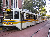
Light rail
RT operates a 37.42 miles (60.22 km) light rail system, consisting of two rail ines, 45 stations, and 76 vehicles. The LRV fleet consist of Siemens-Duewag U2Siemens-Duewag U2
The Siemens-Duewag U2 is a type of light-rail vehicle . The cars were built by consortium of Siemens, Wegmann & Co. and Duewag. The U2 design was built on the Siemens U1 prototype tram built in 1965 ....
A vehicles, which have been in use since the light rail's inception and more modern CAF
Construcciones y Auxiliar de Ferrocarriles
Construcciones y Auxiliar de Ferrocarriles is a rail equipment manufacturer based in Beasain in the Basque Country, Spain. Equipment manufactured by CAF includes light rail vehicles, rapid transit trains, railroad cars and locomotives, as well as variable gauge axles that can be fitted on any...
trains delivered in 2003.
Before the June 2010 budget cuts, RT light rail formerly operated from 4:30 a.m. to 1 a.m. daily with 15 minute headways during the day. (Only the RT bus service division has never operated beyond midnight, even the busiest routes.) After the budget cuts took place, it was curtailed to operate from 4:30 a.m. to 10 p.m. daily, with service every 15 minutes in the day Monday through Friday and every 30 minutes on weekends and every night. The light rail system, with 44,400 daily boardings, is the tenth busiest in the United States.
The creation and maintenance of the light-rail system is pushed by the advocacy group Friends of Light Rail and Transit.
Most popular light rail stations
Numbers provided are average weekday "on & offs"- St. Rose of Lima Park 10,100
- 16th Street 6,500
- Watt/I-80Interstate 80Interstate 80 is the second-longest Interstate Highway in the United States, following Interstate 90. It is a transcontinental artery running from downtown San Francisco, California to Teaneck, New Jersey in the New York City Metropolitan Area...
-29th Street 4,600
Blue Line - Watt/I-80-Downtown-Meadowview Line
Future projects
Future plans include the planned Green Line from the Sacramento Valley Station to the Sacramento International AirportSacramento International Airport
Sacramento International Airport is a public airport located 10 miles northwest of the central business district of Sacramento, in Sacramento County, California, USA. It is run by Sacramento County...
via the neighborhood of Natomas
Natomas, Sacramento, California
Natomas is a community in northwestern Sacramento, California. It is the last area of Sacramento that has not been fully developed, and has seen major residential development in the 1990s and 2000s. Major growth has been mostly due to Power Balance Pavilion, home court to the Sacramento Kings and...
. A planned extension to Roseville
Roseville, California
-2010:The 2010 United States Census reported that Roseville had a population of 118,788. The population density was 3,279.4 people per square mile...
, once a top priority, has been on the back burner for years. Extensions to Davis
Davis, California
Davis is a city in Yolo County, California, United States. It is part of the Sacramento–Arden-Arcade–Roseville Metropolitan Statistical Area...
, Elk Grove
Elk Grove, California
Elk Grove is a city in Sacramento County, California, located just south of the state capital of Sacramento. It is part of the Sacramento–Arden-Arcade–Roseville Metropolitan Statistical Area. As of the 2010 census, the population of the city is 153,015...
, Woodland
Woodland, California
Woodland is the county seat of Yolo County, California, located approximately northwest of Sacramento, and is a part of the Sacramento - Arden-Arcade - Roseville Metropolitan Statistical Area. The population was 55,468 at the 2010 census.Woodland's origins trace back to 1850 when California...
and other locations are shown on the 20-year plan. In December 2007, Regional Transit committed to completing the extension from the Sacramento Valley Station to Richards Blvd by 2010 which would take it through the planned Railyards
Sacramento Railyards
The Sacramento Railyards is an urban infill brownfield project of approximately at the western terminus of the First Transcontinental Railroad in the Richards Boulevard neighborhood of the city of Sacramento, California...
project and extend it to the also planned Township 9 development.
Meadowview to Cosumnes River College
Construction on the Phase 2 plan for the South line extension is currently planned to begin in Spring 2011. It will go as far south as Cosumes River College. Originally a planned extension all the way to the city of Elk Grove, the line will end at the college due to four changes to address feedback from the Federal Transit Administration (FTA) on land use and station accessibility. These changes include a new station at Morrison Creek (half-way between Meadowview and Franklin), improved pedestrian access to Franklin and Center Parkway stations, the elimination of certain design options, and a 2000 car parking structure to replace previously planned surface parking at Cosumnes River College. California's current financial crisis also contributed to the decision to terminate the line at the college. The line might be extended further as part of a possible Phase 3.Paratransit
To meet the requirements of the 1990 Americans with Disabilities Act, the RT established a ParatransitParatransit
Paratransit is an alternative mode of flexible passenger transportation that does not follow fixed routes or schedules. Typically mini-buses are used to provide paratransit service, but also share taxis and jitneys are important providers....
service in 1993, which is a door-to-door service for the disabled.
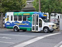
The Neighborhood Ride
In 2006, RT created a new division internally known as "Community Bus Service". Known to the ridership as "The Neighborhood Ride"- The Neighborhood Ride shuttles are smaller buses (approximately 35 feet (10.7 m) or less in length) that offer residents greater mobility and new transit options on local intra-community trips.
- The Neighborhood Ride shuttles have regular, pre-designated, pre-scheduled routes, but offer special curb-to-curb service (not to be confused with ADA/paratransit door-to-door service). The shuttles are able to "deviate" travel off route up to ¾ of a mile to pick up and drop off seniors, age 62 and older, and disabled passengers who have a valid ADA/paratransit pass
- Passengers pay only $1.10 per trip (55 cents for passengers paying a discount fare). RT monthly passes, daily passes, and transfers are also accepted. Passengers with valid ADA/paratransit passes ride free.
- All passengers (except for Lifetime Pass holders), including those with valid ADA/paratransit passes, must pay an additional $1.10 for a route deviation.
- Marked bus stops are located along the route and printed schedules are available at several locations around Sacramento and on Regional Transit's Web site.
- Each shuttle can transport 12-17 passengers and up to two wheelchairs.
Accidents and Incidents
On April 9, 2010 at about 10:20 a.m. a Blue Line train struck a vehicle at the 47th Ave. crossing. The vehicle, a green Honda Accord was dragged about 100 feet (30.5 m). Inside the vehicle was a woman about the age of 40, She was pronounced dead at U.C. Davis Medical Center. The cause was revealed to be the woman who drove her car around the crossing gates which were down.A man was hospitalized April 26, 2010 after he was hit by a light rail while talking on a cell phone.The crash happened near the Iron Point Station in Folsom at about 10 a.m. Investigators said the pedestrian was walking on the tracks and not paying attention to what was coming toward him. The pedestrian on the tracks never looked up at all throughout the entire incident. The operator told investigators that he had spoken to the injured person, and the guy said that he was walking on the tracks because he didn't want to be walking on the roadway while talking on his cell phone. The pedestrian was in serious condition at UC Davis Medical Center. Passengers on the train had an hour delay.
Deputies were called shortly after 9 a.m. on April 27, 2010 to the Zinfandel station. Sheriff's Sgt. Tim Curran said one person shot the victim in the leg and then fled.Investigators said a fight broke out on a light rail train, culminating in a shooting once the train reached the station platform. The alleged shooter was seen running across the parking lot outside a nearby Ross store, Curran said. The victim was expected to survive, authorities said. RT service did not appear to be affected.
On November 11, 2010 a pick up truck ran into the side of a moving Regional Transit Light Rail Train at 10:15 a.m. at Starfire Drive and Folsom Boulevard in Sacramento County. The train was only scratched in the collision. Only one passenger received medical attention for minor injuries; the two people in the truck were not hurt.
A Siemens light rail vehicle on a Gold Line train caught fire and started to smoke on December 23, 2010 at approximately 7:30 a.m. near the College Greens station. A communications issue between the Sacramento Fire Department and the Regional Transit light rail operator occurred when the train began to move from the station where the fire was being doused to the Watt/Manlove station over a mile away. The fire caused service disruptions to Gold Line trains traveling in both directions for up to an hour. The car (#136) was towed out of service to the Regional Transit maintenance facility on Academy Way. The fire was likely caused by an overheated generator and battery located on the bottom of the train.
See also
- List of rapid transit systems
- Light rail in North AmericaLight rail in North AmericaLight rail is a commonly used mode of rapid transit in North America. The term light rail was coined in 1972 by the U.S. Urban Mass Transportation Administration to describe new streetcar transformations which were taking place in Europe and the United States...
- Light RailLight railLight rail or light rail transit is a form of urban rail public transportation that generally has a lower capacity and lower speed than heavy rail and metro systems, but higher capacity and higher speed than traditional street-running tram systems...
- Roseville TransitRoseville TransitRoseville Transit is the operator of mass transportation in the expansive Sacramento, California suburb of Roseville. Fourteen local routes provide intracity service six days per week...
- Placer County TransitPlacer County TransitPlacer County Transit is the operator of mass transportation in the suburbanized western portion of Placer County, California, excluding the city of Roseville. Six route are provided, five of which use transit buses and one that uses commuter coaches as it connects Auburn with downtown Sacramento...