
Antelope, California
Encyclopedia
Antelope is a census-designated place
in Sacramento County
, California
, United States
located approximately 15 miles (24 km) northeast of downtown Sacramento
and 5 miles (8 km) southwest of Roseville
. The population was 45,770 at the 2010 census.
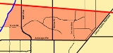
, the community has a total area of 6.8 square miles (17.7 km2). Antelope is mostly flat, with very few hills and no major bodies of water.
The northern border of Antelope falls directly onto the line between Sacramento County and Placer County.
The eastern border first follows Roseville Road south from the county line to Butternut Drive. Then the border continues in the same general direction to Antelope Road, so that parcels on Adagio Way, Andante Drive and Katella Way are within Antelope CDP.
The southern border follows Antelope Road.
The western border has two parts. The first part extends from Antelope Rd northwards toward Elverta Rd along 28th St. The second part extends from Elverta Rd towards the Placer county line, along Dry Creek
.
was 6,694.2 people per square mile (2,584.6/km²). The racial makeup of Antelope was 29,200 (63.8%) White, 4,039 (8.8%) African American, 402 (0.9%) Native American, 6,090 (13.3%) Asian, 407 (0.9%) Pacific Islander, 2,284 (5.0%) from other races
, and 3,348 (7.3%) from two or more races. Hispanic or Latino of any race were 6,635 persons (14.5%).
The Census reported that 45,686 people (99.8% of the population) lived in households, 57 (0.1%) lived in non-institutionalized group quarters, and 27 (0.1%) were institutionalized.
There were 14,159 households, out of which 7,138 (50.4%) had children under the age of 18 living in them, 8,259 (58.3%) were opposite-sex married couples
living together, 2,184 (15.4%) had a female householder with no husband present, 860 (6.1%) had a male householder with no wife present. There were 888 (6.3%) unmarried opposite-sex partnerships
, and 106 (0.7%) same-sex married couples or partnerships. 2,107 households (14.9%) were made up of individuals and 447 (3.2%) had someone living alone who was 65 years of age or older. The average household size was 3.23. There were 11,303 families
(79.8% of all households); the average family size was 3.59.
The population was spread out with 14,253 people (31.1%) under the age of 18, 4,495 people (9.8%) aged 18 to 24, 13,238 people (28.9%) aged 25 to 44, 10,931 people (23.9%) aged 45 to 64, and 2,853 people (6.2%) who were 65 years of age or older. The median age was 31.4 years. For every 100 females there were 94.3 males. For every 100 females age 18 and over, there were 91.2 males.
There were 14,847 housing units at an average density of 2,171.5 per square mile (838.4/km²), of which 9,663 (68.2%) were owner-occupied, and 4,496 (31.8%) were occupied by renters. The homeowner vacancy rate was 2.7%; the rental vacancy rate was 3.9%. 30,801 people (67.3% of the population) lived in owner-occupied housing units and 14,885 people (32.5%) lived in rental housing units.
called Antelope, but it did define a Zip Code Tabulation Area
(ZCTA), 95843. Because Antelope is contained within this ZCTA, it is possible to obtain Census data from the United States 2000 Census for the area even though data for "Antelope" is unavailable.
As of the census of 2000, there were 36,421 people, 11,655 households, and 9,341 families residing in the ZCTA of 95843. The population density
was 5,690 people per square mile (2,180/km2). There were 12,016 housing units at an average density of 1,877.5 per square mile (719.5/km2). The racial makeup of the ZCTA was 65.5% White, 10.1% African American, 0.9% Native American, 11.9% Asian, 0.6% Pacific Islander, 4% from other races, and 7% from two or more races. 10.7% of the population were Hispanic or Latino of any race.
There were 11,655 households out of which 55.4% had children under the age of 18 living with them, 62.4% were married couples
living together, 13.2% had a female householder with no husband present, and 19.9% were non-families. 1.8% had someone living alone who was 65 years of age or older. The average household size was 3.12 and the average family size was 3.47.
In the ZCTA the population was spread out with 37.1% under age 20, 5.6% from 20 to 24, 48.6% from 25 to 54, 4.9% from 55 to 64, and 4% who were 65 years of age or older. The median age was 30.3 years. For every 100 females there were 95.7 males. For every 100 females age 18 and over, there were 90.7 males.
The median income for a household is $59,151, and the median income for a family was $60,840. Males had a median income of $40,573 versus $32,302 for females. The per capita income
for the community was $21,373. 5.4% of the population and 4.1% of families were below the poverty line. Out of the total people living in poverty, 2.5% are under the age of 18 and 4.6% are 65 or older.
Antelope is located in the 6th Senate
District, represented by Democrat
Darrell Steinberg
, and in the 4th Assembly
District, represented by Republican
Ted Gaines
. Federally, Antelope is located in California's California's 3rd congressional district
, which has a Cook PVI
of R +7 and is represented by Republican Dan Lungren
.
courts, a volleyball court, a multipurpose field, and a baseball
diamond. It also contains four barbecue
s and every year is the host of a fireworks festival on the 2nd, 3rd and/or 4 July, with bands playing too.
, with a gate for students to enter from the park. It consists of a plastic playground updated with First 5 Grant money in 2009, swings with handicap access, a baseball field, a soccer field, with many benches and trees to sit under.
, and on the other side of the creek lies Gibson Ranch. This park is not operated by Sunrise Parks and Recreation District. Locals call it hidden park.
This park is finished and a great place to take your children.
. It consists of a baseball diamond, 2 basketball courts, a multipurpose field, a soccer field, benches, bike racks, BBQ and covered picnic tables. The park has children's playsets.
provides electric services to the area and PG&E
provides natural gas services. Half of Antelope is served by Surewest
for its telephone needs and the remainder is served by AT&T
.
Census-designated place
A census-designated place is a concentration of population identified by the United States Census Bureau for statistical purposes. CDPs are delineated for each decennial census as the statistical counterparts of incorporated places such as cities, towns and villages...
in Sacramento County
Sacramento County, California
Sacramento County is a county in the U.S. state of California. Its county seat is Sacramento, which is also the state capital. As of 2010 the county had a population of 1,418,788....
, California
California
California is a state located on the West Coast of the United States. It is by far the most populous U.S. state, and the third-largest by land area...
, United States
United States
The United States of America is a federal constitutional republic comprising fifty states and a federal district...
located approximately 15 miles (24 km) northeast of downtown Sacramento
Sacramento, California
Sacramento is the capital city of the U.S. state of California and the county seat of Sacramento County. It is located at the confluence of the Sacramento River and the American River in the northern portion of California's expansive Central Valley. With a population of 466,488 at the 2010 census,...
and 5 miles (8 km) southwest of Roseville
Roseville, California
-2010:The 2010 United States Census reported that Roseville had a population of 118,788. The population density was 3,279.4 people per square mile...
. The population was 45,770 at the 2010 census.
Geography
According to the United States Census BureauUnited States Census Bureau
The United States Census Bureau is the government agency that is responsible for the United States Census. It also gathers other national demographic and economic data...
, the community has a total area of 6.8 square miles (17.7 km2). Antelope is mostly flat, with very few hills and no major bodies of water.
The northern border of Antelope falls directly onto the line between Sacramento County and Placer County.
The eastern border first follows Roseville Road south from the county line to Butternut Drive. Then the border continues in the same general direction to Antelope Road, so that parcels on Adagio Way, Andante Drive and Katella Way are within Antelope CDP.
The southern border follows Antelope Road.
The western border has two parts. The first part extends from Antelope Rd northwards toward Elverta Rd along 28th St. The second part extends from Elverta Rd towards the Placer county line, along Dry Creek
Dry Creek (American River)
Dry Creek is a long stream in Placer County and Sacramento County, California, USA, tributary to the Sacramento River. Its watershed lies within the Sacramento Valley.. Because suburban development borders much of its length, the stream is noted for its capacity to cause local flooding and as a...
.
2010
The 2010 United States Census reported that Antelope had a population of 45,770. The population densityPopulation density
Population density is a measurement of population per unit area or unit volume. It is frequently applied to living organisms, and particularly to humans...
was 6,694.2 people per square mile (2,584.6/km²). The racial makeup of Antelope was 29,200 (63.8%) White, 4,039 (8.8%) African American, 402 (0.9%) Native American, 6,090 (13.3%) Asian, 407 (0.9%) Pacific Islander, 2,284 (5.0%) from other races
Race (United States Census)
Race and ethnicity in the United States Census, as defined by the Federal Office of Management and Budget and the United States Census Bureau, are self-identification data items in which residents choose the race or races with which they most closely identify, and indicate whether or not they are...
, and 3,348 (7.3%) from two or more races. Hispanic or Latino of any race were 6,635 persons (14.5%).
The Census reported that 45,686 people (99.8% of the population) lived in households, 57 (0.1%) lived in non-institutionalized group quarters, and 27 (0.1%) were institutionalized.
There were 14,159 households, out of which 7,138 (50.4%) had children under the age of 18 living in them, 8,259 (58.3%) were opposite-sex married couples
Marriage
Marriage is a social union or legal contract between people that creates kinship. It is an institution in which interpersonal relationships, usually intimate and sexual, are acknowledged in a variety of ways, depending on the culture or subculture in which it is found...
living together, 2,184 (15.4%) had a female householder with no husband present, 860 (6.1%) had a male householder with no wife present. There were 888 (6.3%) unmarried opposite-sex partnerships
POSSLQ
POSSLQ is an abbreviation for "Persons of Opposite Sex Sharing Living Quarters," a term coined in the late 1970s by the United States Census Bureau as part of an effort to more accurately gauge the prevalence of cohabitation in American households....
, and 106 (0.7%) same-sex married couples or partnerships. 2,107 households (14.9%) were made up of individuals and 447 (3.2%) had someone living alone who was 65 years of age or older. The average household size was 3.23. There were 11,303 families
Family (U.S. Census)
A family or family household is defined by the United States Census Bureau for statistical purposes as "a householder and one or more other people related to the householder by birth, marriage, or adoption. They do not include same-sex married couples even if the marriage was performed in a state...
(79.8% of all households); the average family size was 3.59.
The population was spread out with 14,253 people (31.1%) under the age of 18, 4,495 people (9.8%) aged 18 to 24, 13,238 people (28.9%) aged 25 to 44, 10,931 people (23.9%) aged 45 to 64, and 2,853 people (6.2%) who were 65 years of age or older. The median age was 31.4 years. For every 100 females there were 94.3 males. For every 100 females age 18 and over, there were 91.2 males.
There were 14,847 housing units at an average density of 2,171.5 per square mile (838.4/km²), of which 9,663 (68.2%) were owner-occupied, and 4,496 (31.8%) were occupied by renters. The homeowner vacancy rate was 2.7%; the rental vacancy rate was 3.9%. 30,801 people (67.3% of the population) lived in owner-occupied housing units and 14,885 people (32.5%) lived in rental housing units.
2000
As of the 2000 census, the United States did not define a census-designated placeCensus-designated place
A census-designated place is a concentration of population identified by the United States Census Bureau for statistical purposes. CDPs are delineated for each decennial census as the statistical counterparts of incorporated places such as cities, towns and villages...
called Antelope, but it did define a Zip Code Tabulation Area
ZIP Code Tabulation Area
ZIP Code Tabulation Areas are statistical entities developed by the United States Census Bureau for tabulating summary statistics from Census 2000. This new entity was developed to overcome the difficulties in precisely defining the land area covered by each ZIP code...
(ZCTA), 95843. Because Antelope is contained within this ZCTA, it is possible to obtain Census data from the United States 2000 Census for the area even though data for "Antelope" is unavailable.
As of the census of 2000, there were 36,421 people, 11,655 households, and 9,341 families residing in the ZCTA of 95843. The population density
Population density
Population density is a measurement of population per unit area or unit volume. It is frequently applied to living organisms, and particularly to humans...
was 5,690 people per square mile (2,180/km2). There were 12,016 housing units at an average density of 1,877.5 per square mile (719.5/km2). The racial makeup of the ZCTA was 65.5% White, 10.1% African American, 0.9% Native American, 11.9% Asian, 0.6% Pacific Islander, 4% from other races, and 7% from two or more races. 10.7% of the population were Hispanic or Latino of any race.
There were 11,655 households out of which 55.4% had children under the age of 18 living with them, 62.4% were married couples
Marriage
Marriage is a social union or legal contract between people that creates kinship. It is an institution in which interpersonal relationships, usually intimate and sexual, are acknowledged in a variety of ways, depending on the culture or subculture in which it is found...
living together, 13.2% had a female householder with no husband present, and 19.9% were non-families. 1.8% had someone living alone who was 65 years of age or older. The average household size was 3.12 and the average family size was 3.47.
In the ZCTA the population was spread out with 37.1% under age 20, 5.6% from 20 to 24, 48.6% from 25 to 54, 4.9% from 55 to 64, and 4% who were 65 years of age or older. The median age was 30.3 years. For every 100 females there were 95.7 males. For every 100 females age 18 and over, there were 90.7 males.
The median income for a household is $59,151, and the median income for a family was $60,840. Males had a median income of $40,573 versus $32,302 for females. The per capita income
Per capita income
Per capita income or income per person is a measure of mean income within an economic aggregate, such as a country or city. It is calculated by taking a measure of all sources of income in the aggregate and dividing it by the total population...
for the community was $21,373. 5.4% of the population and 4.1% of families were below the poverty line. Out of the total people living in poverty, 2.5% are under the age of 18 and 4.6% are 65 or older.
Politics
In the state legislatureCalifornia State Legislature
The California State Legislature is the state legislature of the U.S. state of California. It is a bicameral body consisting of the lower house, the California State Assembly, with 80 members, and the upper house, the California State Senate, with 40 members...
Antelope is located in the 6th Senate
California State Senate
The California State Senate is the upper house of the California State Legislature. There are 40 state senators. The state legislature meets in the California State Capitol in Sacramento. The Lieutenant Governor is the ex officio President of the Senate and may break a tied vote...
District, represented by Democrat
Democratic Party (United States)
The Democratic Party is one of two major contemporary political parties in the United States, along with the Republican Party. The party's socially liberal and progressive platform is largely considered center-left in the U.S. political spectrum. The party has the lengthiest record of continuous...
Darrell Steinberg
Darrell Steinberg
Darrell Steven Steinberg is a Democratic politician from Sacramento, California. He is currently serving his second term in the California State Senate, representing the 6th District. He has been the Senate President Pro Tem since 2008...
, and in the 4th Assembly
California State Assembly
The California State Assembly is the lower house of the California State Legislature. There are 80 members in the Assembly, representing an approximately equal number of constituents, with each district having a population of at least 420,000...
District, represented by Republican
Republican Party (United States)
The Republican Party is one of the two major contemporary political parties in the United States, along with the Democratic Party. Founded by anti-slavery expansion activists in 1854, it is often called the GOP . The party's platform generally reflects American conservatism in the U.S...
Ted Gaines
Ted Gaines
Edward M. Gaines is a California State Senator, representing the 1st Senate district. He won a January 4, 2011, special election to replace the late Dave Cox and took office two days later...
. Federally, Antelope is located in California's California's 3rd congressional district
California's 3rd congressional district
California's 3rd congressional district is a congressional district located in the U.S. state of California. It covers most of Sacramento County and part of Solano County, as well as all of Alpine, Amador and Calaveras counties...
, which has a Cook PVI
Cook Partisan Voting Index
The Cook Partisan Voting Index , sometimes referred to as simply the Partisan Voting Index , is a measurement of how strongly an American congressional district or state leans toward one political party compared to the nation as a whole...
of R +7 and is represented by Republican Dan Lungren
Dan Lungren
Daniel Edward "Dan" Lungren is the U.S. Representative for , serving since 2005. The district covers most of Sacramento County and part of Solano County, as well as all of Alpine, Amador and Calaveras counties...
.
Parks
Parks in Antelope are under the jurisdiction of the Sunrise Parks and Recreation District as well as the North Highlands Parks and Recreation District.Tetotom Park
Tetotom Park is located on the corner of Don Julio Blvd and North Loop Dr in Antelope near Antelope Crossing Middle School. It consists of a plastic playground, 2 tennisTennis
Tennis is a sport usually played between two players or between two teams of two players each . Each player uses a racket that is strung to strike a hollow rubber ball covered with felt over a net into the opponent's court. Tennis is an Olympic sport and is played at all levels of society at all...
courts, a volleyball court, a multipurpose field, and a baseball
Baseball
Baseball is a bat-and-ball sport played between two teams of nine players each. The aim is to score runs by hitting a thrown ball with a bat and touching a series of four bases arranged at the corners of a ninety-foot diamond...
diamond. It also contains four barbecue
Barbecue
Barbecue or barbeque , used chiefly in the United States, Canada, the United Kingdom, New Zealand and Australia is a method and apparatus for cooking meat, poultry and occasionally fish with the heat and hot smoke of a fire, smoking wood, or hot coals of...
s and every year is the host of a fireworks festival on the 2nd, 3rd and/or 4 July, with bands playing too.
Pokelma Park
Pokelma Park is located on Quiet Knolls Drive off of Elverta Road(behind WinCo Foods). It consists of a plastic playground, 2 tennis courts, a basketball court, and a baseball diamond.Lone Oak Park
Lone Oak Park is at Elverta and Gray Mare Way, located directly next to Center High SchoolCenter High School (Antelope, California)
Center High School is a high school located located at 3111 Center Court Lane, in Antelope, California, United States. The school opened up in its current location in 1984. It is one the of the two high schools in the Center Unified School District.-History:...
, with a gate for students to enter from the park. It consists of a plastic playground updated with First 5 Grant money in 2009, swings with handicap access, a baseball field, a soccer field, with many benches and trees to sit under.
Blue Oak Park
Blue Oak Park is located at Big Cloud and Heathston Ct, behind Bel-Air Market (Big Cloud leads to a dead end at Old Walerga, which is blocked by a fence from both the park and Big Cloud). It consists of multiple plastic playground and a big, grassy field. There are no restrooms.Antelope Greens Park
This park is located at Meadow Hawk and Tourmaline Way, which is in a neighbor hood in between Center High School and McClellan High School off Watt Ave. It is almost hidden to the public, on a dirt section, behind some houses and the offskirts of a golf course (which is blocked by a huge fence). You cannot actually see the park from the streets, just the dirt road and a big gate, which is closed and locked at night. The park contains one small basketball court and a plastic playground. It is located directly next to Dry CreekDry Creek
-Communities:Australia*Dry Creek, South Australia, a suburb of AdelaideUnited States*Dry Creek, Alaska in the Southeast Fairbanks Census Area*Dry Creek, Louisiana in Beauregard Parish*Dry Creek, Oklahoma in Cherokee County...
, and on the other side of the creek lies Gibson Ranch. This park is not operated by Sunrise Parks and Recreation District. Locals call it hidden park.
Antelope Community Park
Antelope Community Park is mainly known as The Park of Dreams, which is the name listed on a painted wall in front of the park. It is located at 8012 Palmerson Drive, directly next to the local fire station. The park consists a wooden playground (which has been replaced with plastic and metal) that is shaped like a fortress. It contains a huge dirt field with a walking area and many benches and the park is 34 acres (137,593.2 m²) total.This park is finished and a great place to take your children.
Antelope Station Park
Antelope Station Park is a park for the youngest children. Contains one small play set, a garden and some benches. It is located at 6306 Outlook Drive.Almond Grove
Almond Grove is located at 7691 Eagle Point Way. It's just a 4.5 acres (18,210.9 m²) field with no playsets.Firestone Park
Firestone park is a 7.5 acres (30,351.5 m²) park located at 5415 Poker Lane near Olive Grove Elementary SchoolOlive Grove Elementary School
Olive Grove Elementary School, serves grades K–5 in the Dry Creek Joint Elementary School District. This school is located at 7926 Firestone Way, in Antelope, California, United States.- External links :* * *...
. It consists of a baseball diamond, 2 basketball courts, a multipurpose field, a soccer field, benches, bike racks, BBQ and covered picnic tables. The park has children's playsets.
Roseview Park
Roseview Park is a 7 acres (28,328 m²) park located at 5848 Ridgepoint Drive. It consists of one play area, a BBQ, a garden area, a baseball diamond and a basketball courtElementary Schools (K-5)
- Oak Hill Elementary School
- Dudley Elementary School
- North Country Elementary School
- Spinelli Elementary School
High Schools
- Center High SchoolCenter High School (Antelope, California)Center High School is a high school located located at 3111 Center Court Lane, in Antelope, California, United States. The school opened up in its current location in 1984. It is one the of the two high schools in the Center Unified School District.-History:...
- McClellan Continuation High School
Charter School
- Antelope View Charter School (located at the lower part of the old Center Junior High School)
- Global Youth Charter School (located at the upper part of the old Center Junior High School)
Elementary Schools (K-5)
- Antelope Meadows Elementary
- Barrett Ranch Elementary
- Olive Grove ElementaryOlive Grove Elementary SchoolOlive Grove Elementary School, serves grades K–5 in the Dry Creek Joint Elementary School District. This school is located at 7926 Firestone Way, in Antelope, California, United States.- External links :* * *...
- Heritage Oak Elementary
- Coyote Ridge Elementary
- Quail Glen Elementary
- Dry Creek Elementary
Junior High Schools (6-8)
- Antelope Crossing Middle School
- Creekview Ranch Middle School
- Silverado Middle School
Roseville Joint Union High School District
- Antelope High SchoolAntelope High SchoolAntelope High School is one the of the five high schools in the Roseville Joint Union High School District. This school is located at 7801 Titan Drive, in Antelope, California, United States. Antelope High School opened up for 9th and 10th grade students at the beginning of the 2008-2009 school...
- Oakmont High SchoolOakmont High SchoolOakmont High School is located at 1710 Cirby Way, in Roseville, California, United States. The school is surrounded by the communities of Citrus Heights, Rocklin, Granite Bay, and Antelope. It is one of five comprehensive high schools in the Roseville Joint Union High School District. Oakmont...
Utilities
Sacramento Municipal Utility DistrictSMUD
The Sacramento Municipal Utility District provides electricity to Sacramento County, California, and a small portion of adjacent Placer County, established under the Municipal Utility District Act...
provides electric services to the area and PG&E
Pacific Gas and Electric Company
The Pacific Gas and Electric Company , commonly known as PG&E, is the utility that provides natural gas and electricity to most of the northern two-thirds of California, from Bakersfield almost to the Oregon border...
provides natural gas services. Half of Antelope is served by Surewest
Surewest
SureWest is a Roseville, CA based telecommunications company, servicing the Greater Sacramento Valley and Kansas City region markets. SureWest was founded in 1914 by William Doyle as the Roseville Telephone Company - SureWest became the official name in 2003...
for its telephone needs and the remainder is served by AT&T
AT&T
AT&T Inc. is an American multinational telecommunications corporation headquartered in Whitacre Tower, Dallas, Texas, United States. It is the largest provider of mobile telephony and fixed telephony in the United States, and is also a provider of broadband and subscription television services...
.