
South Lake Tahoe, California
Encyclopedia
South Lake Tahoe is the most populous city in El Dorado County
, California
, in the Sierra Nevada Mountains. The population was 21,403 at the 2010 census, down from 23,609 at the 2000 census. The east end of the city, on the California
-Nevada
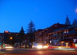
state line, is mainly geared towards tourism, with T-shirt shops, restaurants, hotels, and Heavenly Mountain Resort with the Nevada casinos just across the state line in Stateline, Nevada
. The city extends about five miles (8 km) west-southwest along U.S. Route 50, also known as Lake Tahoe Blvd. The western end of town is mainly residential, and clusters around "The Y" (new intersection October 2008), the X-shaped intersection of US 50, State Route 89
, and the continuation of Lake Tahoe Boulevard after it loses its Federal highway designation.
According to the United States Census Bureau
, the city has a total area of 16.6 square miles (43 km²), of which, 10.2 square miles (26.4 km²) of it is land and 6.4 square miles (16.6 km²) of it (38.80%) is water. Its elevation is about 6260 feet (1,908 m).
 The 2010 United States Census reported that South Lake Tahoe had a population of 21,403. The population density
was 1,289.1 people per square mile (497.7/km²). The racial makeup of South Lake Tahoe was 15,733 (73.5%) White, 182 (0.9%) African American, 232 (1.1%) Native American, 1,186 (5.5%) Asian, 39 (0.2%) Pacific Islander, 3,230 (15.1%) from other races
, and 801 (3.7%) from two or more races. Hispanic or Latino of any race were 6,665 persons (31.1%).
The Census reported that 21,034 people (98.3% of the population) lived in households, 181 (0.8%) lived in non-institutionalized group quarters, and 188 (0.9%) were institutionalized.
There were 8,918 households, out of which 2,421 (27.1%) had children under the age of 18 living in them, 3,100 (34.8%) were opposite-sex married couples
living together, 983 (11.0%) had a female householder with no husband present, 594 (6.7%) had a male householder with no wife present. There were 857 (9.6%) unmarried opposite-sex partnerships
, and 67 (0.8%) same-sex married couples or partnerships. 2,918 households (32.7%) were made up of individuals and 652 (7.3%) had someone living alone who was 65 years of age or older. The average household size was 2.36. There were 4,677 families
(52.4% of all households); the average family size was 3.06.
The population was spread out with 4,400 people (20.6%) under the age of 18, 2,478 people (11.6%) aged 18 to 24, 6,416 people (30.0%) aged 25 to 44, 6,013 people (28.1%) aged 45 to 64, and 2,096 people (9.8%) who were 65 years of age or older. The median age was 35.6 years. For every 100 females there were 113.6 males. For every 100 females age 18 and over, there were 115.7 males.
There were 15,087 housing units at an average density of 908.7 per square mile (350.8/km²), of which 3,473 (38.9%) were owner-occupied, and 5,445 (61.1%) were occupied by renters. The homeowner vacancy rate was 4.5%; the rental vacancy rate was 14.6%. 7,684 people (35.9% of the population) lived in owner-occupied housing units and 13,350 people (62.4%) lived in rental housing units.
of 2010, there were 21,403 people, 9,410 households, and 5,391 families residing in the city. The population density
was 2,347.5 people per square mile (906.1/km²). There were 14,005 housing units at an average density of 1,392.5 per square mile (537.5/km²). The racial makeup of the city was 75.73% White
, 0.75% Black
or African American
, 0.97% Native American
, 6.01% Asian
, 0.17% Pacific Islander
, 12.48% from other races
, and 3.90% from two or more races. 26.66% of the population were Hispanic
or Latino
of any race.
There were 9,410 households out of which 30.9% had children under the age of 18 living with them, 39.3% were married couples
living together, 12.0% had a female householder with no husband present, and 42.7% were non-families. 29.1% of all households were made up of individuals and 7.1% had someone living alone who was 65 years of age or older. The average household size was 2.50 and the average family size was 3.15.
In the city the population was spread out with 25.2% under the age of 18, 11.4% from 18 to 24, 33.0% from 25 to 44, 21.9% from 45 to 64, and 8.6% who were 65 years of age or older. The median age was 33 years. For every 100 females there were 107.0 males. For every 100 females age 18 and over, there were 107.4 males.
The median income
for a household in the city was $34,707, and the median income for a family was $40,572. Males had a median income of $26,352 versus $22,280 for females. The per capita income
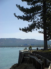
for the city was $18,452. About 9.1% of families and 12.5% of the population were below the poverty line, including 13.7% of those under age 18 and 7.0% of those age 65 or over. South Lake Tahoe is located at 38°55′45"N 119°59′4"W (38.929237, -119.984347). As its name suggests it is located on the southern shore of Lake Tahoe
, right next to the Nevada
border and the town of Stateline, Nevada
.
South Lake Tahoe is located in the 1st Senate
District, represented by Republican
Ted Gaines
, and in the 4th Assembly
District, represented by Beth Gaines, wife of Ted Gaines. Federally, South Lake Tahoe is located in California's 4th congressional district
, which has a Cook PVI
of R +11 and is represented by Republican Tom McClintock
.
, Bijou
, Bijou Park
, Stateline
, Tahoe Valley
, and Tallac Village
. A post office was established in 1967. In 1991, Jaycee Lee Dugard was abducted from a bus-stop in South Lake Tahoe, aged 11. She was found in 2009 in Antioch, California
18 years later.
Lady Luck arrived at the Lake and unpacked her bags in 1944, when Harvey's Wagon Wheel Saloon and Gambling Hall opened as one of the area's first gaming establishments. But competition soon sprang up and so did the need for more permanent accommodations. By the 1950s, roads began to be plowed year-round, enabling access to permanent residences. When the 1960 Winter Olympics came to Squaw Valley, Lake Tahoe was put firmly on the map as the skiing center of the western United States.

 On Sunday, 24 June 2007, a wildfire
broke out at the Seneca Pond recreation area. Known as the Angora Fire, the situation was the worst of its kind in Lake Tahoe history.
The fire spread throughout the region destroying homes and forests. Highway closures followed by evacuations put the city in the direct line of the fire. Hotels in the area responded by opening their doors to the hundreds of evacuees that needed shelter.
On 25 June, a state of emergency was announced by Lt. Gov. John Garamendi
acting on behalf of the absent Governor Arnold Schwarzenegger
who was traveling in Europe
. No lives were lost. Over three thousand acres (12.5 square kilometers) were burned with more than 275 structures, including 254 homes and 26 buildings damaged. On 27 June, Governor Arnold Schwarzenegger
, toured the area after he returned to California.
Full containment of the fire was announced on 2 July 2007.
El Dorado County, California
El Dorado County is a county located in the historic Gold Country in the Sierra Nevada Mountains and foothills of the U.S. state of California. The 2010 population was 181,058. The El Dorado county seat is in Placerville....
, California
California
California is a state located on the West Coast of the United States. It is by far the most populous U.S. state, and the third-largest by land area...
, in the Sierra Nevada Mountains. The population was 21,403 at the 2010 census, down from 23,609 at the 2000 census. The east end of the city, on the California
California
California is a state located on the West Coast of the United States. It is by far the most populous U.S. state, and the third-largest by land area...
-Nevada
Nevada
Nevada is a state in the western, mountain west, and southwestern regions of the United States. With an area of and a population of about 2.7 million, it is the 7th-largest and 35th-most populous state. Over two-thirds of Nevada's people live in the Las Vegas metropolitan area, which contains its...
state line, is mainly geared towards tourism, with T-shirt shops, restaurants, hotels, and Heavenly Mountain Resort with the Nevada casinos just across the state line in Stateline, Nevada
Stateline, Nevada
-Demographics:As of the census of 2000, there were 1,215 people, 510 households, and 245 families residing in the CDP. The population density was 1,803.3 people per square mile . There were 562 housing units at an average density of 834.1 per square mile...
. The city extends about five miles (8 km) west-southwest along U.S. Route 50, also known as Lake Tahoe Blvd. The western end of town is mainly residential, and clusters around "The Y" (new intersection October 2008), the X-shaped intersection of US 50, State Route 89
California State Route 89
State Route 89 is a California State Highway that travels in the north–south direction, and is the major thoroughfare for many mountain communities. It starts from U.S. Route 395 near Topaz Lake, winding its way up to the Monitor Pass, down to the Carson River, and up again over the Luther...
, and the continuation of Lake Tahoe Boulevard after it loses its Federal highway designation.
According to the United States Census Bureau
United States Census Bureau
The United States Census Bureau is the government agency that is responsible for the United States Census. It also gathers other national demographic and economic data...
, the city has a total area of 16.6 square miles (43 km²), of which, 10.2 square miles (26.4 km²) of it is land and 6.4 square miles (16.6 km²) of it (38.80%) is water. Its elevation is about 6260 feet (1,908 m).
2010
Population density
Population density is a measurement of population per unit area or unit volume. It is frequently applied to living organisms, and particularly to humans...
was 1,289.1 people per square mile (497.7/km²). The racial makeup of South Lake Tahoe was 15,733 (73.5%) White, 182 (0.9%) African American, 232 (1.1%) Native American, 1,186 (5.5%) Asian, 39 (0.2%) Pacific Islander, 3,230 (15.1%) from other races
Race (United States Census)
Race and ethnicity in the United States Census, as defined by the Federal Office of Management and Budget and the United States Census Bureau, are self-identification data items in which residents choose the race or races with which they most closely identify, and indicate whether or not they are...
, and 801 (3.7%) from two or more races. Hispanic or Latino of any race were 6,665 persons (31.1%).
The Census reported that 21,034 people (98.3% of the population) lived in households, 181 (0.8%) lived in non-institutionalized group quarters, and 188 (0.9%) were institutionalized.
There were 8,918 households, out of which 2,421 (27.1%) had children under the age of 18 living in them, 3,100 (34.8%) were opposite-sex married couples
Marriage
Marriage is a social union or legal contract between people that creates kinship. It is an institution in which interpersonal relationships, usually intimate and sexual, are acknowledged in a variety of ways, depending on the culture or subculture in which it is found...
living together, 983 (11.0%) had a female householder with no husband present, 594 (6.7%) had a male householder with no wife present. There were 857 (9.6%) unmarried opposite-sex partnerships
POSSLQ
POSSLQ is an abbreviation for "Persons of Opposite Sex Sharing Living Quarters," a term coined in the late 1970s by the United States Census Bureau as part of an effort to more accurately gauge the prevalence of cohabitation in American households....
, and 67 (0.8%) same-sex married couples or partnerships. 2,918 households (32.7%) were made up of individuals and 652 (7.3%) had someone living alone who was 65 years of age or older. The average household size was 2.36. There were 4,677 families
Family (U.S. Census)
A family or family household is defined by the United States Census Bureau for statistical purposes as "a householder and one or more other people related to the householder by birth, marriage, or adoption. They do not include same-sex married couples even if the marriage was performed in a state...
(52.4% of all households); the average family size was 3.06.
The population was spread out with 4,400 people (20.6%) under the age of 18, 2,478 people (11.6%) aged 18 to 24, 6,416 people (30.0%) aged 25 to 44, 6,013 people (28.1%) aged 45 to 64, and 2,096 people (9.8%) who were 65 years of age or older. The median age was 35.6 years. For every 100 females there were 113.6 males. For every 100 females age 18 and over, there were 115.7 males.
There were 15,087 housing units at an average density of 908.7 per square mile (350.8/km²), of which 3,473 (38.9%) were owner-occupied, and 5,445 (61.1%) were occupied by renters. The homeowner vacancy rate was 4.5%; the rental vacancy rate was 14.6%. 7,684 people (35.9% of the population) lived in owner-occupied housing units and 13,350 people (62.4%) lived in rental housing units.
2000
As of the censusCensus
A census is the procedure of systematically acquiring and recording information about the members of a given population. It is a regularly occurring and official count of a particular population. The term is used mostly in connection with national population and housing censuses; other common...
of 2010, there were 21,403 people, 9,410 households, and 5,391 families residing in the city. The population density
Population density
Population density is a measurement of population per unit area or unit volume. It is frequently applied to living organisms, and particularly to humans...
was 2,347.5 people per square mile (906.1/km²). There were 14,005 housing units at an average density of 1,392.5 per square mile (537.5/km²). The racial makeup of the city was 75.73% White
Race (United States Census)
Race and ethnicity in the United States Census, as defined by the Federal Office of Management and Budget and the United States Census Bureau, are self-identification data items in which residents choose the race or races with which they most closely identify, and indicate whether or not they are...
, 0.75% Black
Race (United States Census)
Race and ethnicity in the United States Census, as defined by the Federal Office of Management and Budget and the United States Census Bureau, are self-identification data items in which residents choose the race or races with which they most closely identify, and indicate whether or not they are...
or African American
Race (United States Census)
Race and ethnicity in the United States Census, as defined by the Federal Office of Management and Budget and the United States Census Bureau, are self-identification data items in which residents choose the race or races with which they most closely identify, and indicate whether or not they are...
, 0.97% Native American
Race (United States Census)
Race and ethnicity in the United States Census, as defined by the Federal Office of Management and Budget and the United States Census Bureau, are self-identification data items in which residents choose the race or races with which they most closely identify, and indicate whether or not they are...
, 6.01% Asian
Race (United States Census)
Race and ethnicity in the United States Census, as defined by the Federal Office of Management and Budget and the United States Census Bureau, are self-identification data items in which residents choose the race or races with which they most closely identify, and indicate whether or not they are...
, 0.17% Pacific Islander
Race (United States Census)
Race and ethnicity in the United States Census, as defined by the Federal Office of Management and Budget and the United States Census Bureau, are self-identification data items in which residents choose the race or races with which they most closely identify, and indicate whether or not they are...
, 12.48% from other races
Race (United States Census)
Race and ethnicity in the United States Census, as defined by the Federal Office of Management and Budget and the United States Census Bureau, are self-identification data items in which residents choose the race or races with which they most closely identify, and indicate whether or not they are...
, and 3.90% from two or more races. 26.66% of the population were Hispanic
Race (United States Census)
Race and ethnicity in the United States Census, as defined by the Federal Office of Management and Budget and the United States Census Bureau, are self-identification data items in which residents choose the race or races with which they most closely identify, and indicate whether or not they are...
or Latino
Race (United States Census)
Race and ethnicity in the United States Census, as defined by the Federal Office of Management and Budget and the United States Census Bureau, are self-identification data items in which residents choose the race or races with which they most closely identify, and indicate whether or not they are...
of any race.
There were 9,410 households out of which 30.9% had children under the age of 18 living with them, 39.3% were married couples
Marriage
Marriage is a social union or legal contract between people that creates kinship. It is an institution in which interpersonal relationships, usually intimate and sexual, are acknowledged in a variety of ways, depending on the culture or subculture in which it is found...
living together, 12.0% had a female householder with no husband present, and 42.7% were non-families. 29.1% of all households were made up of individuals and 7.1% had someone living alone who was 65 years of age or older. The average household size was 2.50 and the average family size was 3.15.
In the city the population was spread out with 25.2% under the age of 18, 11.4% from 18 to 24, 33.0% from 25 to 44, 21.9% from 45 to 64, and 8.6% who were 65 years of age or older. The median age was 33 years. For every 100 females there were 107.0 males. For every 100 females age 18 and over, there were 107.4 males.
The median income
Income
Income is the consumption and savings opportunity gained by an entity within a specified time frame, which is generally expressed in monetary terms. However, for households and individuals, "income is the sum of all the wages, salaries, profits, interests payments, rents and other forms of earnings...
for a household in the city was $34,707, and the median income for a family was $40,572. Males had a median income of $26,352 versus $22,280 for females. The per capita income
Per capita income
Per capita income or income per person is a measure of mean income within an economic aggregate, such as a country or city. It is calculated by taking a measure of all sources of income in the aggregate and dividing it by the total population...
for the city was $18,452. About 9.1% of families and 12.5% of the population were below the poverty line, including 13.7% of those under age 18 and 7.0% of those age 65 or over. South Lake Tahoe is located at 38°55′45"N 119°59′4"W (38.929237, -119.984347). As its name suggests it is located on the southern shore of Lake Tahoe
Lake Tahoe
Lake Tahoe is a large freshwater lake in the Sierra Nevada of the United States. At a surface elevation of , it is located along the border between California and Nevada, west of Carson City. Lake Tahoe is the largest alpine lake in North America. Its depth is , making it the USA's second-deepest...
, right next to the Nevada
Nevada
Nevada is a state in the western, mountain west, and southwestern regions of the United States. With an area of and a population of about 2.7 million, it is the 7th-largest and 35th-most populous state. Over two-thirds of Nevada's people live in the Las Vegas metropolitan area, which contains its...
border and the town of Stateline, Nevada
Stateline, Nevada
-Demographics:As of the census of 2000, there were 1,215 people, 510 households, and 245 families residing in the CDP. The population density was 1,803.3 people per square mile . There were 562 housing units at an average density of 834.1 per square mile...
.
Politics
In the state legislatureCalifornia State Legislature
The California State Legislature is the state legislature of the U.S. state of California. It is a bicameral body consisting of the lower house, the California State Assembly, with 80 members, and the upper house, the California State Senate, with 40 members...
South Lake Tahoe is located in the 1st Senate
California State Senate
The California State Senate is the upper house of the California State Legislature. There are 40 state senators. The state legislature meets in the California State Capitol in Sacramento. The Lieutenant Governor is the ex officio President of the Senate and may break a tied vote...
District, represented by Republican
Republican Party (United States)
The Republican Party is one of the two major contemporary political parties in the United States, along with the Democratic Party. Founded by anti-slavery expansion activists in 1854, it is often called the GOP . The party's platform generally reflects American conservatism in the U.S...
Ted Gaines
Ted Gaines
Edward M. Gaines is a California State Senator, representing the 1st Senate district. He won a January 4, 2011, special election to replace the late Dave Cox and took office two days later...
, and in the 4th Assembly
California State Assembly
The California State Assembly is the lower house of the California State Legislature. There are 80 members in the Assembly, representing an approximately equal number of constituents, with each district having a population of at least 420,000...
District, represented by Beth Gaines, wife of Ted Gaines. Federally, South Lake Tahoe is located in California's 4th congressional district
California's 4th congressional district
California's 4th congressional district is a congressional district located in the U.S. state of California. It covers the northeastern corner of California along Route 395, encompassing El Dorado, Placer, Nevada, Sierra, Plumas, Lassen, and Modoc counties, as well as parts of Butte County...
, which has a Cook PVI
Cook Partisan Voting Index
The Cook Partisan Voting Index , sometimes referred to as simply the Partisan Voting Index , is a measurement of how strongly an American congressional district or state leans toward one political party compared to the nation as a whole...
of R +11 and is represented by Republican Tom McClintock
Tom McClintock
Thomas Miller McClintock II is the U.S. Representative for , serving since 2009. He is a member of the Republican Party. He is a former Assemblyman and state Senator...
.
History
The city incorporated in 1965 by combining the previously unincorporated communities of Al TahoeAl Tahoe, California
Al Tahoe is a former unincorporated community now incorporated in South Lake Tahoe in El Dorado County, California. It lies at an elevation of 6253 feet ....
, Bijou
Bijou, California
Bijou is a former unincorporated community now incorporated in South Lake Tahoe in El Dorado County, California. It lies at an elevation of 6243 feet ....
, Bijou Park
Bijou Park, California
Bijou Park is a former unincorporated community now incorporated in South Lake Tahoe in El Dorado County, California. It is located east of Bijou, at an elevation of 6237 feet ....
, Stateline
Stateline, California
Stateline is a former unincorporated community in El Dorado County, California, now incorporated into South Lake Tahoe, California. It lies at an elevation of 6279 feet . As its name suggests, it is at the border with Nevada.A post office operated at Stateline from 1901. The name Laphams...
, Tahoe Valley
Tahoe Valley, California
Tahoe Valley is a former unincorporated community in El Dorado County, California, now incorporated into South Lake Tahoe. It lies at an elevation of 6270 feet . Tahoe Valley is about the junction of U.S. Route 50 and California State Route 89....
, and Tallac Village
Tallac Village, California
Tallac Village is an unincorporated community in El Dorado County, California. It lies at an elevation of 6263 feet ....
. A post office was established in 1967. In 1991, Jaycee Lee Dugard was abducted from a bus-stop in South Lake Tahoe, aged 11. She was found in 2009 in Antioch, California
Antioch, California
Antioch is a city in Contra Costa County, California. Located in the East Bay region of the San Francisco Bay Area along the San Joaquin-Sacramento River Delta, it is a suburb of San Francisco and Oakland. The city's population was 102,372 at the U.S...
18 years later.
Lady Luck arrived at the Lake and unpacked her bags in 1944, when Harvey's Wagon Wheel Saloon and Gambling Hall opened as one of the area's first gaming establishments. But competition soon sprang up and so did the need for more permanent accommodations. By the 1950s, roads began to be plowed year-round, enabling access to permanent residences. When the 1960 Winter Olympics came to Squaw Valley, Lake Tahoe was put firmly on the map as the skiing center of the western United States.
Landscape
Climate
South Lake Tahoe has a highland climate with mild to warm summers and cold snowy winters.Angora Fire
Wildfire
A wildfire is any uncontrolled fire in combustible vegetation that occurs in the countryside or a wilderness area. Other names such as brush fire, bushfire, forest fire, desert fire, grass fire, hill fire, squirrel fire, vegetation fire, veldfire, and wilkjjofire may be used to describe the same...
broke out at the Seneca Pond recreation area. Known as the Angora Fire, the situation was the worst of its kind in Lake Tahoe history.
The fire spread throughout the region destroying homes and forests. Highway closures followed by evacuations put the city in the direct line of the fire. Hotels in the area responded by opening their doors to the hundreds of evacuees that needed shelter.
On 25 June, a state of emergency was announced by Lt. Gov. John Garamendi
John Garamendi
John Raymond Garamendi is the U.S. Representative for , serving since November 2009. He is a member of the Democratic Party. Garamendi was the California State Insurance Commissioner from 1991 to 1995, the U.S. Deputy Secretary of the Interior from 1995 to 1998, and the California State Insurance...
acting on behalf of the absent Governor Arnold Schwarzenegger
Arnold Schwarzenegger
Arnold Alois Schwarzenegger is an Austrian-American former professional bodybuilder, actor, businessman, investor, and politician. Schwarzenegger served as the 38th Governor of California from 2003 until 2011....
who was traveling in Europe
Europe
Europe is, by convention, one of the world's seven continents. Comprising the westernmost peninsula of Eurasia, Europe is generally 'divided' from Asia to its east by the watershed divides of the Ural and Caucasus Mountains, the Ural River, the Caspian and Black Seas, and the waterways connecting...
. No lives were lost. Over three thousand acres (12.5 square kilometers) were burned with more than 275 structures, including 254 homes and 26 buildings damaged. On 27 June, Governor Arnold Schwarzenegger
Arnold Schwarzenegger
Arnold Alois Schwarzenegger is an Austrian-American former professional bodybuilder, actor, businessman, investor, and politician. Schwarzenegger served as the 38th Governor of California from 2003 until 2011....
, toured the area after he returned to California.
Full containment of the fire was announced on 2 July 2007.