

Metropolitan Fresno
Encyclopedia
Metropolitan Fresno or officially Fresno-Madera, CA CSA is a metropolitan area in California's Central Valley consisting of Fresno
and Madera
counties in the southern area of Northern California
. It is the second largest metropolitan region
in the Central Valley, the first being Greater Sacramento, and 42nd largest in the United States as of 2010 census.
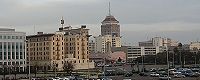
Metropolitan Fresno is anchored by Fresno
, the fifth largest city in California and the 35th largest in the United States. The metropolitan area's Central Valley location, which is one of the world's most productive agricultural regions, allows a large agricultural economy despite being increasingly urbanized.
 Metropolitan Fresno, unlike the other metropolitan regions of California, is still largely agricultural and contains a large rural land area and is centered in the San Joaquin Valley
. The metropolitan area is located between the larger metropolitan areas of California, bordering the southernmost boundaries of the San Francisco Bay Area
in the west and separated from the Greater Sacramento and Greater Los Angeles Area
s to the north and south respectively by long distances of rural and farmland. Additionally, the lifestyle and culture of Metropolitan Fresno does not reflect the San Francisco or Sacramento influence as other areas have in Northern California due to distance from the state capital and bordering an unpopulated area of the outskirts of the Bay Area. Instead, Metropolitan Fresno is more influenced by the interior valley region of California although as the area becomes more urbanized, it has become slightly more influenced by the other metropolitan areas of Northern California, particularly the Bay Area.
Fresno
is the largest city in the area and in the Central Valley. Along with Sacramento
, it is the economic center of California's interior and is one of the fastest growing cities in the United States, with the region having a growth of over 20% since 2000. Additionally, Fresno is a major transportation hub for visitors heading to Yosemite
, Kings Canyon National Park
and Sequoia National Park
s, which are both 60 mi (97 km) and 75 mi (121 km) away from Fresno respectively and Fresno is the nearest major city from the parks. The United States Military
has a heavy presence in the Fresno area and numerous divisions are based in Metropolitan Fresno, including the 40th Aviation Brigade and 144th Fighter Wing
. Fresno County is the largest agricultural county and has the largest concentration of agriculture than any other county in the United States.
Madera County is primarily an agricultural county as well but its cities serve as suburbs of Fresno.
, which in turn is a part of the larger Central Valley region of California, one of the world's most important agricultural areas. The eastern portions of the area border the Sierra Nevada mountains and the western portions border the Coast Ranges, thus giving the edges of the area higher elevations than the inner valley areas. Several waterways traverse the region, including the San Joaquin
and Kings River
s, Delta–Mendota Canal and Madera Canal
. Additionally, the California Aqueduct
runs through the area, providing water to crops and is one of the world's longest artificial aqueducts.
(Köppen
Csa) with some semi-arid factors due to its interior location (Köppen Bsh), with mild, moderately wet winters and hot and dry summers. December is the coolest month, with an average of 53.4 °F (11.9 °C) during the day in downtown Fresno while summer temperatures can reach 110 °F (43.3 °C) or more. Thick tule fog
is present in the valley areas during the winter. Rainfall is most common between December and April while snowfall is sometimes experienced in the higher mountain elevations.
 Owing to its gateway location to numerous national parks as well as being in between the larger Greater Los Angeles
and San Francisco Bay Area
and Greater Sacramento regions, Metropolitan Fresno serves as a transportation hub in the California interior. However, unlike the larger metropolitan areas of California, Metropolitan Fresno does not have a large public transit system but is served by numerous freeways and highways.
with Southern California
and its location in between the three larger metropolitan areas of the state allows for a large trucking industry as well as services to travelers. Highways and freeways in Metropolitan Fresno include:
is the only commercial airport in the region and is a major gateway into Yosemite National Park
. Additionally, there are several general aviation airports in the area, including Fresno Chandler Executive Airport
, Firebaugh Airport
, Sierra Sky Park Airport
and Madera Municipal Airport
.
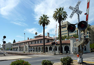
rail stations are located in the area, Santa Fe Passenger Depot
and Madera
which are on the San Joaquin line. Fresno Area Express
and Madera County Express serve as bus transit lines connecting to downtown Fresno. Greyhound
and Orange Belt Stages
provide long distance bus travel to the area.
stronghold and the region reflects the Coastal California
and interior California divide in which coastal areas and urbanized areas of California tend to lean Democratic
while interior areas tend to lean Republican. Exceptions to this are Orange County
in Greater Los Angeles, which has been a Republican stronghold since the 1940s, and most of Greater Sacramento, which is a politically competitive area where the major parties are often divided in pluralities although recently there have been Democratic majorities. Metropolitan Fresno has began to become a politically competitive region as well, as in the 2008 presidential election
, the region was split with Fresno County going for Barack Obama
with the majority of the votes, while John McCain
carried Madera County with a comfortable margin. Locally, Democratic concentrations are found in much of Fresno and most non-agricultural suburbs while Republican concentrations are found in Madera County and most rural towns.
Fresno County, California
Fresno County is a county located in the Central Valley of the U.S. state of California, south of Stockton and north of Bakersfield. As of the 2010 census, it is the tenth most populous county in California with a population of 930,450, and the sixth largest in size with an area of . The county...
and Madera
Madera County, California
Madera County is a county of the U.S. state of California, located in the Central Valley and the Sierra Nevada north of Fresno County. It comprises the Madera-Chowchilla, CA Metropolitan Statistical Area. As of the 2010 census the population was 150,865...
counties in the southern area of Northern California
Northern California
Northern California is the northern portion of the U.S. state of California. The San Francisco Bay Area , and Sacramento as well as its metropolitan area are the main population centers...
. It is the second largest metropolitan region
Combined Statistical Area
The United States Office of Management and Budget defines micropolitan and metropolitan statistical areas. Metropolitan and micropolitan statistical areas consist of one or more counties...
in the Central Valley, the first being Greater Sacramento, and 42nd largest in the United States as of 2010 census.
Metropolitan Fresno is anchored by Fresno
Fresno, California
Fresno is a city in central California, United States, the county seat of Fresno County. As of the 2010 census, the city's population was 510,365, making it the fifth largest city in California, the largest inland city in California, and the 34th largest in the nation...
, the fifth largest city in California and the 35th largest in the United States. The metropolitan area's Central Valley location, which is one of the world's most productive agricultural regions, allows a large agricultural economy despite being increasingly urbanized.
Counties
| County name | Population (2010 U.S. Census) | Land area |
|---|---|---|
| Fresno Fresno County, California Fresno County is a county located in the Central Valley of the U.S. state of California, south of Stockton and north of Bakersfield. As of the 2010 census, it is the tenth most populous county in California with a population of 930,450, and the sixth largest in size with an area of . The county... |
930,450 | 5963 sq mi (15,444.1 km²) |
| Madera Madera County, California Madera County is a county of the U.S. state of California, located in the Central Valley and the Sierra Nevada north of Fresno County. It comprises the Madera-Chowchilla, CA Metropolitan Statistical Area. As of the 2010 census the population was 150,865... |
150,865 | 2136 sq mi (5,532.2 km²) |
| Metropolitan Fresno | 1,081,315 | 8099 sq mi (20,976.3 km²) |
Overview
San Joaquin Valley
The San Joaquin Valley is the area of the Central Valley of California that lies south of the Sacramento – San Joaquin River Delta in Stockton...
. The metropolitan area is located between the larger metropolitan areas of California, bordering the southernmost boundaries of the San Francisco Bay Area
San Francisco Bay Area
The San Francisco Bay Area, commonly known as the Bay Area, is a populated region that surrounds the San Francisco and San Pablo estuaries in Northern California. The region encompasses metropolitan areas of San Francisco, Oakland, and San Jose, along with smaller urban and rural areas...
in the west and separated from the Greater Sacramento and Greater Los Angeles Area
Greater Los Angeles Area
The Greater Los Angeles Area, or the Southland, is a term used for the Combined Statistical Area sprawled over five counties in the southern part of California, namely Los Angeles County, Orange County, San Bernardino County, Riverside County and Ventura County...
s to the north and south respectively by long distances of rural and farmland. Additionally, the lifestyle and culture of Metropolitan Fresno does not reflect the San Francisco or Sacramento influence as other areas have in Northern California due to distance from the state capital and bordering an unpopulated area of the outskirts of the Bay Area. Instead, Metropolitan Fresno is more influenced by the interior valley region of California although as the area becomes more urbanized, it has become slightly more influenced by the other metropolitan areas of Northern California, particularly the Bay Area.
Fresno
Fresno, California
Fresno is a city in central California, United States, the county seat of Fresno County. As of the 2010 census, the city's population was 510,365, making it the fifth largest city in California, the largest inland city in California, and the 34th largest in the nation...
is the largest city in the area and in the Central Valley. Along with Sacramento
Sacramento, California
Sacramento is the capital city of the U.S. state of California and the county seat of Sacramento County. It is located at the confluence of the Sacramento River and the American River in the northern portion of California's expansive Central Valley. With a population of 466,488 at the 2010 census,...
, it is the economic center of California's interior and is one of the fastest growing cities in the United States, with the region having a growth of over 20% since 2000. Additionally, Fresno is a major transportation hub for visitors heading to Yosemite
Yosemite National Park
Yosemite National Park is a United States National Park spanning eastern portions of Tuolumne, Mariposa and Madera counties in east central California, United States. The park covers an area of and reaches across the western slopes of the Sierra Nevada mountain chain...
, Kings Canyon National Park
Kings Canyon National Park
Kings Canyon National Park is a National Park in the southern Sierra Nevada, east of Fresno, California. The park was established in 1940 and covers...
and Sequoia National Park
Sequoia National Park
Sequoia National Park is a national park in the southern Sierra Nevada east of Visalia, California, in the United States. It was established on September 25, 1890. The park spans . Encompassing a vertical relief of nearly , the park contains among its natural resources the highest point in the...
s, which are both 60 mi (97 km) and 75 mi (121 km) away from Fresno respectively and Fresno is the nearest major city from the parks. The United States Military
Military of the United States
The United States Armed Forces are the military forces of the United States. They consist of the Army, Navy, Marine Corps, Air Force, and Coast Guard.The United States has a strong tradition of civilian control of the military...
has a heavy presence in the Fresno area and numerous divisions are based in Metropolitan Fresno, including the 40th Aviation Brigade and 144th Fighter Wing
144th Fighter Wing
The United States Air Force's 144th Fighter Wing is a unit of the California Air National Guard, operationally gained by the Air Combat Command and located at Fresno Air National Guard Base / Fresno Yosemite International Airport in Fresno, California....
. Fresno County is the largest agricultural county and has the largest concentration of agriculture than any other county in the United States.
Madera County is primarily an agricultural county as well but its cities serve as suburbs of Fresno.
Geography
Metropolitan Fresno is primarily located in the San Joaquin ValleySan Joaquin Valley
The San Joaquin Valley is the area of the Central Valley of California that lies south of the Sacramento – San Joaquin River Delta in Stockton...
, which in turn is a part of the larger Central Valley region of California, one of the world's most important agricultural areas. The eastern portions of the area border the Sierra Nevada mountains and the western portions border the Coast Ranges, thus giving the edges of the area higher elevations than the inner valley areas. Several waterways traverse the region, including the San Joaquin
San Joaquin River
The San Joaquin River is the largest river of Central California in the United States. At over long, the river starts in the high Sierra Nevada, and flows through a rich agricultural region known as the San Joaquin Valley before reaching Suisun Bay, San Francisco Bay, and the Pacific Ocean...
and Kings River
Kings River (California)
The Kings River is a major river of south-central California. About long, it drains an area of the high western Sierra Nevada and the Central Valley. A large alluvial fan has formed where the river's gradient decreases in the Central Valley so the river divides into distributaries...
s, Delta–Mendota Canal and Madera Canal
Madera Canal
The Madera Canal is a aqueduct in the U.S. state of California. It is part of the Central Valley Project managed by the United States Bureau of Reclamation to convey water north to augment irrigation capacity in Madera County, California. It was also the subject of the United States Supreme...
. Additionally, the California Aqueduct
California Aqueduct
The Governor Edmund G. Brown California Aqueduct is a system of canals, tunnels, and pipelines that conveys water collected from the Sierra Nevada Mountains and valleys of Northern- and Central California to Southern California. The Department of Water Resources operates and maintains the...
runs through the area, providing water to crops and is one of the world's longest artificial aqueducts.
Climate
Metropolitan Fresno has a Mediterranean climateMediterranean climate
A Mediterranean climate is the climate typical of most of the lands in the Mediterranean Basin, and is a particular variety of subtropical climate...
(Köppen
Köppen climate classification
The Köppen climate classification is one of the most widely used climate classification systems. It was first published by Crimea German climatologist Wladimir Köppen in 1884, with several later modifications by Köppen himself, notably in 1918 and 1936...
Csa) with some semi-arid factors due to its interior location (Köppen Bsh), with mild, moderately wet winters and hot and dry summers. December is the coolest month, with an average of 53.4 °F (11.9 °C) during the day in downtown Fresno while summer temperatures can reach 110 °F (43.3 °C) or more. Thick tule fog
Tule fog
Tule fog is a thick ground fog that settles in the San Joaquin Valley and Sacramento Valley areas of California's Great Central Valley. Tule fog forms during the late fall and winter after the first significant rainfall. The official time frame for tule fog to form is from November 1 to March 31...
is present in the valley areas during the winter. Rainfall is most common between December and April while snowfall is sometimes experienced in the higher mountain elevations.
Cities
| County seat County seat A county seat is an administrative center, or seat of government, for a county or civil parish. The term is primarily used in the United States.... |
| City | County | Population (January 1, 2010) | Land area |
|---|---|---|---|
| Chowchilla Chowchilla, California Chowchilla is a city in Madera County, California, United States. Chowchilla is located northwest of Madera, at an elevation of 240 feet . It is a principal city of the Madera–Chowchilla Metropolitan Statistical Area. The population was 18,720 at the 2010 census, up from 11,127 at the 2000... |
Madera Madera County, California Madera County is a county of the U.S. state of California, located in the Central Valley and the Sierra Nevada north of Fresno County. It comprises the Madera-Chowchilla, CA Metropolitan Statistical Area. As of the 2010 census the population was 150,865... |
18,698 | 7.1 sq mi (18.4 km²) |
| Clovis Clovis, California Clovis is a city in Fresno County, California, United States, northeast of Fresno. The population is estimated to be 97,218 as of September, 2011. Clovis is located northeast of downtown Fresno, at an elevation of 361 feet .-History:... |
Fresno Fresno County, California Fresno County is a county located in the Central Valley of the U.S. state of California, south of Stockton and north of Bakersfield. As of the 2010 census, it is the tenth most populous county in California with a population of 930,450, and the sixth largest in size with an area of . The county... |
97,218 | 22.03 sq mi (57.1 km²) |
| Coalinga Coalinga, California Coalinga is a city in Fresno County, California. The population was 13,380 at the 2010 census, up from 11,668 at the 2000 census. It is the site of both Pleasant Valley State Prison and Coalinga State Hospital. Coalinga is located southwest of Fresno, at an elevation of 673 feet .-Early... |
Fresno Fresno County, California Fresno County is a county located in the Central Valley of the U.S. state of California, south of Stockton and north of Bakersfield. As of the 2010 census, it is the tenth most populous county in California with a population of 930,450, and the sixth largest in size with an area of . The county... |
19,065 | 5.9 sq mi (15.3 km²) |
| Firebaugh Firebaugh, California Firebaugh is a city in Fresno County, California, United States. The population was 7,549 at the 2010 census, up from 5,743 as of the 2000 census. ZIP Code for the community is 93622 and the city is located inside area code 559. Firebaugh is located on the west side of the San Joaquin River west... |
Fresno Fresno County, California Fresno County is a county located in the Central Valley of the U.S. state of California, south of Stockton and north of Bakersfield. As of the 2010 census, it is the tenth most populous county in California with a population of 930,450, and the sixth largest in size with an area of . The county... |
6,941 | 2.8 sq mi (7.3 km²) |
| Fowler Fowler, California Fowler is a city in Fresno County, California, United States. It is located within the San Joaquin Valley. It has a strong agricultural community, with lush grape vineyards and expansive farmland. Fowler is located southeast of downtown Fresno, at an elevation of 308 feet... |
Fresno Fresno County, California Fresno County is a county located in the Central Valley of the U.S. state of California, south of Stockton and north of Bakersfield. As of the 2010 census, it is the tenth most populous county in California with a population of 930,450, and the sixth largest in size with an area of . The county... |
5,764 | 22 sq mi (5.2 km²) |
| Fresno Fresno, California Fresno is a city in central California, United States, the county seat of Fresno County. As of the 2010 census, the city's population was 510,365, making it the fifth largest city in California, the largest inland city in California, and the 34th largest in the nation... |
Fresno Fresno County, California Fresno County is a county located in the Central Valley of the U.S. state of California, south of Stockton and north of Bakersfield. As of the 2010 census, it is the tenth most populous county in California with a population of 930,450, and the sixth largest in size with an area of . The county... |
502,303 | 104.4 sq mi (270.4 km²) |
| Huron Huron, California Huron is a small city in Fresno County, California, in the United States. As of the 2010 census, the population was 6,754, up from 6,306 at the 2000 census. During the harvest season, the population swells to over 15,000 people due to the influx of migrant farm workers. Huron is located ... |
Fresno Fresno County, California Fresno County is a county located in the Central Valley of the U.S. state of California, south of Stockton and north of Bakersfield. As of the 2010 census, it is the tenth most populous county in California with a population of 930,450, and the sixth largest in size with an area of . The county... |
8,062 | 1.3 sq mi (3.4 km²) |
| Kerman Kerman, California Kerman is a city at the intersection of State Route 180 and State Route 145 in Fresno County, California, USA. The population was 13,544 at the 2010 census. Kerman is located west of Fresno, at an elevation of 220 feet .... |
Fresno Fresno County, California Fresno County is a county located in the Central Valley of the U.S. state of California, south of Stockton and north of Bakersfield. As of the 2010 census, it is the tenth most populous county in California with a population of 930,450, and the sixth largest in size with an area of . The county... |
14,381 | 2.2 sq mi (5.7 km²) |
| Kingsburg Kingsburg, California Kingsburg is a city in Fresno County, California. Kingsburg is located southeast of Selma at an elevation of 302 feet , on the banks of the Kings River. The city is half an hour away from Fresno, and two hours away from the California Central Coast and Sierra Nevada Mountain Range... |
Fresno Fresno County, California Fresno County is a county located in the Central Valley of the U.S. state of California, south of Stockton and north of Bakersfield. As of the 2010 census, it is the tenth most populous county in California with a population of 930,450, and the sixth largest in size with an area of . The county... |
11,504 | 2.3 sq mi (6 km²) |
| Madera Madera, California Madera is a city in and the county seat of Madera County, California, United States. It is a principal city of the Madera–Chowchilla Metropolitan Statistical Area, which encompasses all of Madera County, and Metropolitan Fresno. It is located in California's San Joaquin Valley. As of the 2010... |
Madera Madera County, California Madera County is a county of the U.S. state of California, located in the Central Valley and the Sierra Nevada north of Fresno County. It comprises the Madera-Chowchilla, CA Metropolitan Statistical Area. As of the 2010 census the population was 150,865... |
58,243 | 12.3 sq mi (31.9 km²) |
| Mendota Mendota, California Mendota is a city in Fresno County, California, United States. The population was 11,014 at the 2010 census. The State Routes 180 and 33 run through the agricultural city. Mendota is located south-southeast of Firebaugh, at an elevation of 174 feet .... |
Fresno Fresno County, California Fresno County is a county located in the Central Valley of the U.S. state of California, south of Stockton and north of Bakersfield. As of the 2010 census, it is the tenth most populous county in California with a population of 930,450, and the sixth largest in size with an area of . The county... |
9,966 | 1.9 sq mi (4.9 km²) |
| Orange Cove Orange Cove, California Orange Cove is a small city in Fresno County, California, United States. The population was 9,078 at the 2010 census, up from 7,722 at the 2000 census. Almost all of Orange Cove's residents are Hispanic, many of whom are farmers... |
Fresno Fresno County, California Fresno County is a county located in the Central Valley of the U.S. state of California, south of Stockton and north of Bakersfield. As of the 2010 census, it is the tenth most populous county in California with a population of 930,450, and the sixth largest in size with an area of . The county... |
11,089 | 1.5 sq mi (3.9 km²) |
| Parlier Parlier, California Parlier is a city in Fresno County, California, United States. As of the 2010 census, the city had a total population of 9,494, down from 11,145 at the 2000 census. The city has one of the state's highest percentage of Latinos, a large majority of them are seasonal migrant laborers who arrive and... |
Fresno Fresno County, California Fresno County is a county located in the Central Valley of the U.S. state of California, south of Stockton and north of Bakersfield. As of the 2010 census, it is the tenth most populous county in California with a population of 930,450, and the sixth largest in size with an area of . The county... |
13,658 | 1.6 sq mi (4.1 km²) |
| Reedley Reedley, California Reedley is a city in Fresno County, California, United States. Reedley is located east-southeast of Fresno, at an elevation of 348 feet . The population at the 2010 census was 24,194. Its chief economic source is agriculture, particularly fruit and vegetable cultivation. The city is dubbed as... |
Fresno Fresno County, California Fresno County is a county located in the Central Valley of the U.S. state of California, south of Stockton and north of Bakersfield. As of the 2010 census, it is the tenth most populous county in California with a population of 930,450, and the sixth largest in size with an area of . The county... |
26,227 | 4.4 sq mi (11.4 km²) |
| Sanger Sanger, California Sanger is a city in Fresno County, California, United States. The population was 24,270 at the 2010 census, up from 18,731 at the 2000 census. Sanger is located east-southeast of Fresno, at an elevation of 371 feet .- Geography :... |
Fresno Fresno County, California Fresno County is a county located in the Central Valley of the U.S. state of California, south of Stockton and north of Bakersfield. As of the 2010 census, it is the tenth most populous county in California with a population of 930,450, and the sixth largest in size with an area of . The county... |
25,664 | 4.7 sq mi (12.2 km²) |
| San Joaquin San Joaquin, California San Joaquin is a city in Fresno County, California, United States. The population was 4,001 at the 2010 census, up from 3,270 at the 2000 census. The nearest high school in the area is Tranquillity High School in Tranquillity... |
Fresno Fresno County, California Fresno County is a county located in the Central Valley of the U.S. state of California, south of Stockton and north of Bakersfield. As of the 2010 census, it is the tenth most populous county in California with a population of 930,450, and the sixth largest in size with an area of . The county... |
4,071 | 11 sq mi (2.6 km²) |
| Selma Selma, California Selma is a city in Fresno County, California. The population was 23,219 at the 2010 census, up from 19,240 at the 2000 census. Selma is located southeast of Fresno, at an elevation of 308 feet .-Geography:... |
Fresno Fresno County, California Fresno County is a county located in the Central Valley of the U.S. state of California, south of Stockton and north of Bakersfield. As of the 2010 census, it is the tenth most populous county in California with a population of 930,450, and the sixth largest in size with an area of . The county... |
23,435 | 4.3 sq mi (11.1 km²) |
Census-designated places
- AuberryAuberry, CaliforniaAuberry is a census-designated place in Fresno County, California, United States. The population was 2,369 at the 2010 census, up from 2,053 at the 2000 census...
- BiolaBiola, CaliforniaBiola is a census-designated place in Fresno County, California, United States. The population was 1,623 at the 2010 census, up from 1,037 at the 2000 census...
- Bonadelle Ranchos-Madera RanchosBonadelle Ranchos-Madera Ranchos, CaliforniaBonadelle Ranchos-Madera Ranchos is a census-designated place in Madera County, California, United States. It is part of the Madera–Chowchilla Metropolitan Statistical Area...
- BowlesBowles, CaliforniaBowles is a census-designated place in Fresno County, California, United States. The population was 166 at the 2010 census, down from 182 at the 2000 census...
- CalwaCalwa, CaliforniaCalwa is an unincorporated census-designated place in Fresno County, California, U.S. The population was 2,052 at the 2010 census, up from 762 at the 2000 census. Calwa is located south-southeast of downtown Fresno, at an elevation of 292 feet...
- Cantua CreekCantua Creek, CaliforniaCantua Creek is a census-designated place in Fresno County, California, United States. As of the 2010 census, the population was 466, down from the 655 reported at the 2000 census...
- CaruthersCaruthers, CaliforniaCaruthers is a census-designated place in Fresno County, California, United States. The population was 2,497 at the 2010 census, up from 2,103 at the 2000 census...
- Del ReyDel Rey, CaliforniaDel Rey is a census-designated place in Fresno County, California, United States. The population was 1,639 at the 2010 census, up from 950 at the 2000 census...
- EastonEaston, CaliforniaEaston is a census-designated place in Fresno County, California, United States. The population was 2,083 at the 2010 census, up from 1,966 at the 2000 census...
- FriantFriant, CaliforniaFriant is a census-designated place in Fresno County, California, United States. The population was 549 at the 2010 census, down from 778 at the 2000 census. Friant is located north of Clovis, at an elevation of 344 feet .-Geography:Friant is located at...
- LanareLanare, CaliforniaLanare is a community and census-designated place in Fresno County, California, United States. The population was 589 at the 2010 census, up from 540 at the 2000 census. Lanare is located south-southwest of Fresno, at an elevation of 207 feet . The name is derived from Llewellyn A...
- LatonLaton, CaliforniaLaton is a census-designated place in Fresno County, California, United States. The population was 1,824 at the 2010 census, up from 1,236 at the 2000 census...
- Madera AcresMadera Acres, CaliforniaMadera Acres is a census-designated place in Madera County, California, United States. It is part of the Madera–Chowchilla Metropolitan Statistical Area...
- OakhurstOakhurst, CaliforniaOakhurst is a census-designated place in Madera County, California, south of the entrance to Yosemite National Park, in the foothills of the Sierra Nevada mountain range. Oakhurst is located on the Fresno River south-southwest of Yosemite Forks, at an elevation of 2274 feet...
- ParksdaleParksdale, CaliforniaParksdale is a census-designated place in Madera County, California, United States. It is part of the Madera–Chowchilla Metropolitan Statistical Area...
- ParkwoodParkwood, CaliforniaParkwood is a census-designated place in Madera County, California, United States. It is part of the Madera–Chowchilla Metropolitan Statistical Area...
- Raisin CityRaisin City, CaliforniaRaisin City is a census-designated place in Fresno County, California, United States. The population was 380 at the 2010 census, up from 165 at the 2000 census...
- RiverdaleRiverdale, CaliforniaRiverdale is a census-designated place in Fresno County, California, United States. The population was 3,153 at the 2010 census, up from 2,416 at the 2000 census...
- Shaver LakeShaver Lake, CaliforniaShaver Lake is a census-designated place in Fresno County, California, United States. The population was 634 at the 2010 census, down from 705 at the 2000 census. Shaver Lake is on the southeast end of the lake of the same name, northeast of New Auberry, at an elevation of 5627 feet . The name...
- Squaw ValleySquaw Valley, CaliforniaSquaw Valley, California may refer to:*Squaw Valley, Fresno County, California, census-designated place located in Fresno County, California*Squaw Valley, Placer County, California, community in Placer County, California and host of the 1960 Winter Olympics...
- TranquillityTranquillity, CaliforniaTranquillity is a census-designated place in Fresno County, California, United States. The population was 799 at the 2010 census, down from 813 at the 2000 census. Tranquillity High School is the only high school in Tranquillity...
- Yosemite LakesYosemite Lakes, CaliforniaYosemite Lakes is a census-designated place in Madera County, California, United States. It is part of the Madera–Chowchilla Metropolitan Statistical Area...
Transportation
Greater Los Angeles Area
The Greater Los Angeles Area, or the Southland, is a term used for the Combined Statistical Area sprawled over five counties in the southern part of California, namely Los Angeles County, Orange County, San Bernardino County, Riverside County and Ventura County...
and San Francisco Bay Area
San Francisco Bay Area
The San Francisco Bay Area, commonly known as the Bay Area, is a populated region that surrounds the San Francisco and San Pablo estuaries in Northern California. The region encompasses metropolitan areas of San Francisco, Oakland, and San Jose, along with smaller urban and rural areas...
and Greater Sacramento regions, Metropolitan Fresno serves as a transportation hub in the California interior. However, unlike the larger metropolitan areas of California, Metropolitan Fresno does not have a large public transit system but is served by numerous freeways and highways.
Highways and freeways
Metropolitan Fresno is served by a large number of highways and freeways that are vital in linking the rest of Northern CaliforniaNorthern California
Northern California is the northern portion of the U.S. state of California. The San Francisco Bay Area , and Sacramento as well as its metropolitan area are the main population centers...
with Southern California
Southern California
Southern California is a megaregion, or megapolitan area, in the southern area of the U.S. state of California. Large urban areas include Greater Los Angeles and Greater San Diego. The urban area stretches along the coast from Ventura through the Southland and Inland Empire to San Diego...
and its location in between the three larger metropolitan areas of the state allows for a large trucking industry as well as services to travelers. Highways and freeways in Metropolitan Fresno include:
- Interstate 5
.svg.png) Interstate 5 in CaliforniaInterstate 5 is a major north–south route of the Interstate Highway System in the U.S. state of California. It begins at the Mexico – United States border at the San Ysidro crossing, goes north across the length of California and crosses into Oregon south of the Medford-Ashland metropolitan...
Interstate 5 in CaliforniaInterstate 5 is a major north–south route of the Interstate Highway System in the U.S. state of California. It begins at the Mexico – United States border at the San Ysidro crossing, goes north across the length of California and crosses into Oregon south of the Medford-Ashland metropolitan... - State Route 33
 California State Route 33State Route 33 is a north–south state highway in the U.S. state of California. SR 33 replaced part of U.S. Route 399 in 1964 during the "great renumbering" of routes. In the unincorporated sections of Kern County it is known as the West Side Highway...
 - State Route 41
 California State Route 41State Route 41 is a state highway in the U.S. state of California, connecting the Cabrillo Highway in Morro Bay with Fresno and Yosemite National Park via the San Joaquin Valley. Except between US 101 in Atascadero and SR 46 near Shandon, SR 41 is part of the California Freeway and Expressway...
 - State Route 43
 California State Route 43State Route 43 is a north–south state highway in the U.S. State of California, routed along the southern San Joaquin Valley connecting the towns of Shafter, Wasco, Hanford, and Selma, running roughly parallel to SR 99...
 - State Route 49
 California State Route 49State Route 49 is a north–south state highway in the U.S. state of California that passes through many historic mining communities of the 1849 California gold rush. Highway 49 is numbered after the "49ers", the waves of immigrants who swept into the area looking for gold, and a portion of it...
 - State Route 63
 California State Route 63State Route 63 is a north–south state highway in the U.S. state of California in the Central Valley. It begins from near Tulare at Route 137, runs north through the city of Visalia and the towns of Cutler and Orosi, before ending north of Orange Cove, where it reaches its northern terminus...
 - State Route 99
 California State Route 99California State Route 99 , commonly known as Highway 99 or, simply, as 99 , is a north–south state highway in the U.S. state of California, stretching almost the entire length of the Central Valley...
- State Route 145
 California State Route 145State Route 145 is a state highway in California, USA, which runs through the heart of the San Joaquin Valley from Interstate 5 north to Route 41 north of Fresno.-Route description:SR 145 is part of the California Freeway and Expressway System....
 - State Route 152
 California State Route 152State Route 152 is a state highway that runs near the latitudinal middle of the U.S. state of California from Watsonville to Route 99 southeast of Merced...
 - State Route 168
 California State Route 168State Route 168 is a state highway in California, USA, which is separated into three distinct segments, in part by the Sierra Nevada mountains....
 - State Route 180
 California State Route 180State Route 180 is a state highway in California, United States, which runs through the heart of the San Joaquin Valley from Mendota through Fresno to Kings Canyon National Park, with an unbuilt segment defined west to Paicines....
 - State Route 198
 California State Route 198State Route 198 is an east–west state highway that connects the California Central Coast to the mid-Central Valley at Visalia, although the most-traveled portion is in the Central Valley itself....
 - State Route 201
 California State Route 201State Route 201 is a state highway in the Central Valley of California, USA. It connects Route 99 in Kingsburg with Route 245. Route 63 bridges a discontinuity in the middle of the route.-Route description:...
 - State Route 269
 California State Route 269State Route 269 is a state highway in California, USA, which runs from Avenal to State Route 145.-Route description:The southern terminus of SR 269 is at State Route 33 in Avenal, where it drops into the San Joaquin Valley at I-5...
Air
The Fresno Yosemite International AirportFresno Yosemite International Airport
Fresno Yosemite International Airport , formerly known as Fresno Air Terminal, is a joint civil-military public airport located in eastern Fresno, in Fresno County, California. The airport is more than south of Yosemite National Park on California State Route 41. The airport covers and has two...
is the only commercial airport in the region and is a major gateway into Yosemite National Park
Yosemite National Park
Yosemite National Park is a United States National Park spanning eastern portions of Tuolumne, Mariposa and Madera counties in east central California, United States. The park covers an area of and reaches across the western slopes of the Sierra Nevada mountain chain...
. Additionally, there are several general aviation airports in the area, including Fresno Chandler Executive Airport
Fresno Chandler Executive Airport
Fresno Chandler Executive Airport is a public use airport located two nautical miles west of the central business district of Fresno, a city in Fresno County, California, United States. It is owned by the City of Fresno....
, Firebaugh Airport
Firebaugh Airport
Firebaugh Airport , formerly Q49, is a public airport located one mile west of Firebaugh, serving Fresno County, California, USA. The airport is mostly used for general aviation.- Facilities :...
, Sierra Sky Park Airport
Sierra Sky Park Airport
Sierra Sky Park Airport is a privately owned, public-use airport located seven miles northwest of the central business district of Fresno, a city in Fresno County, California, United States....
and Madera Municipal Airport
Madera Municipal Airport
Madera Municipal Airport is a city-owned public-use airport located three nautical miles northwest of the central business district of Madera, a city in Madera County, California, United States...
.
Public transit
Metropolitan Fresno's central California location allows it to be a large rail transport center. Two AmtrakAmtrak California
Amtrak California is a brand name used by the Caltrans Division of Rail for all state-supported Amtrak rail routes within the U.S. State of California...
rail stations are located in the area, Santa Fe Passenger Depot
Santa Fe Passenger Depot (Fresno)
The Santa Fe Passenger Depot is a railroad station located in Fresno, California. It is currently used by Amtrak, the national passenger railroad system, for its San Joaquin passenger train service....
and Madera
Madera (Amtrak station)
Madera is an unstaffed station on the Amtrak San Joaquin line in Madera, California. The station has one platform which serves a single track. An unattended parking lot is available at the station, but long-term parking is discouraged....
which are on the San Joaquin line. Fresno Area Express
Fresno Area Express
The Fresno Area Express or FAX, is a bus line in Fresno, California. The line has over 100 buses and 20 fixed routes as of May 2008. FAX offers free transfers as well as wheelchair lifts and bike racks on all buses....
and Madera County Express serve as bus transit lines connecting to downtown Fresno. Greyhound
Greyhound Lines
Greyhound Lines, Inc., based in Dallas, Texas, is an intercity common carrier of passengers by bus serving over 3,700 destinations in the United States, Canada and Mexico, operating under the well-known logo of a leaping greyhound. It was founded in Hibbing, Minnesota, USA, in 1914 and...
and Orange Belt Stages
Orange Belt Stages
Orange Belt Stages is a bus company based in Visalia, California. OBS was incorporated on November 30, 1935, and offers charters anywhere in the U.S. and Canada, as well as scheduled runs in California and to Las Vegas, Nevada.-History:...
provide long distance bus travel to the area.
Politics
Unlike the other metropolitan areas of California, Metropolitan Fresno has historically been a strong RepublicanRepublican Party (United States)
The Republican Party is one of the two major contemporary political parties in the United States, along with the Democratic Party. Founded by anti-slavery expansion activists in 1854, it is often called the GOP . The party's platform generally reflects American conservatism in the U.S...
stronghold and the region reflects the Coastal California
Coastal California
Coastal California refers to the coastal regions of the US state of California. The term is not primarily geographical as it also describes an area distinguished by sociological, economical and political attributes...
and interior California divide in which coastal areas and urbanized areas of California tend to lean Democratic
Democratic Party (United States)
The Democratic Party is one of two major contemporary political parties in the United States, along with the Republican Party. The party's socially liberal and progressive platform is largely considered center-left in the U.S. political spectrum. The party has the lengthiest record of continuous...
while interior areas tend to lean Republican. Exceptions to this are Orange County
Orange County, California
Orange County is a county in the U.S. state of California. Its county seat is Santa Ana. As of the 2010 census, its population was 3,010,232, up from 2,846,293 at the 2000 census, making it the third most populous county in California, behind Los Angeles County and San Diego County...
in Greater Los Angeles, which has been a Republican stronghold since the 1940s, and most of Greater Sacramento, which is a politically competitive area where the major parties are often divided in pluralities although recently there have been Democratic majorities. Metropolitan Fresno has began to become a politically competitive region as well, as in the 2008 presidential election
United States presidential election, 2008
The United States presidential election of 2008 was the 56th quadrennial presidential election. It was held on November 4, 2008. Democrat Barack Obama, then the junior United States Senator from Illinois, defeated Republican John McCain, the senior U.S. Senator from Arizona. Obama received 365...
, the region was split with Fresno County going for Barack Obama
Barack Obama
Barack Hussein Obama II is the 44th and current President of the United States. He is the first African American to hold the office. Obama previously served as a United States Senator from Illinois, from January 2005 until he resigned following his victory in the 2008 presidential election.Born in...
with the majority of the votes, while John McCain
John McCain
John Sidney McCain III is the senior United States Senator from Arizona. He was the Republican nominee for president in the 2008 United States election....
carried Madera County with a comfortable margin. Locally, Democratic concentrations are found in much of Fresno and most non-agricultural suburbs while Republican concentrations are found in Madera County and most rural towns.