

New Zealand place names
Encyclopedia
Most New Zealand place-names are derived from Māori and British
sources. Both groups used names to commemorate notable people, events, places from their homeland, their ships or to described the surrounding area. The Māori did not have a collective name for New Zealand
before European arrival, but post-colonisation the name Aotearoa
(commonly translated as 'long white cloud') was used to refer to the whole country. Dutch cartographers named the islands Nova Zeelandia and British explorer James Cook
subsequently anglicised the name to New Zealand. The two main islands are known simply as the North
and South Island
s, although those names have never been formalised.
Many of the early Māori names were replaced by Europeans during the late 18th and early 19th century. Government amendments
in 1894 and the establishment of the New Zealand Geographic Board
in the mid 1940s led to the encouragement of original Māori names, although incorrect spellings and pronunciations persisted. Many names now have alternative or dual
English and Maori names or, in a few rare cases, dual Māori names or dual English names. Most names have never been made official and if they are mentioned in authoritative publications they are considered recorded names. Colloquial names in New Zealand result from an ironic view of the places entertainment value, plays on advertising mottos, or are shortened versions of the full name. Some places tried to capitalise on the success of the Lord of the Rings
films by linking themselves to the movies.
and South Island
; including Te Ika a Māui (the fish of Māui
) for the North Island and Te Wai Pounamu
(the waters of greenstone) or Te Waka o Aoraki (the canoe of Aoraki) for the South Island
. Until the early 20th century, Māori also referred to the North Island as Aotearoa
, (commonly translated as 'long white cloud'); in modern Māori usage this has become the name for the whole country.
The first European visitor to New Zealand, Dutch
explorer Abel Tasman
, named the islands Staten Landt, believing it formed part of the land
which Jacob Le Maire
had seen off the coast of Tierra del Fuego
. Hendrik Brouwer
proved the supposedly South American land an island in 1643, and Dutch cartographers subsequently renamed Tasman's discovery to Nova Zeelandia, after the Dutch province of Zeeland
. The Latin
Nova Zeelandia became Nieuw Zeeland in Dutch
and British explorer James Cook
subsequently called the archipelago New Zealand, using the anglicised form of the Dutch name.
The 1840 Letters Patent
established New Zealand as a British colony and claimed the "principal islands" of New Zealand, identified by their commonly-known names at the time: the Northern Island (the North Island), the Middle Island (the South Island) and Stewart's Island or "South Island". The letters patent attempted to rename the islands to New Ulster
, New Munster and New Leinster
after the provinces in Ireland. New Ulster, New Munster and New Leinster were also used for the initial provinces of New Zealand
, but the names did not endure. In the 1830s the South Island was used as an alternative to Middle Island and by 1907 it became the common name. The North and South Island names arose through common usage rather than official decleration and in 2009 it was revealed that they had never been formalised.
 Many Māori place names possess either historical or mythological significance. Their meaning is not always apparent using literal translations and they were passed down through oral tradition. Before European arrival place names commemorated notable or historical incidents, described features of the location or were derived from traditional Hawaiki
names or myths. After European arrival many locations became known as Māori versions of European words or poorly pronounced contractions of the original Māori names.
Early Māori explorers Kupe
, Ngahue
, and Toi
, named many of New Zealand's coastal features. Like later European explorers, they named things after themselves, their family-members and events that occurred at the newly-discovered location. Kahumatamomoe
named Manukau Harbour
after a manuka
-stake that he used to claim ownership of the area, and Kaipara Harbour
after the para fern he ate there (kai means food). The Māori name for Wellington Harbour
, Te Whanganui a Tara, derives from Tara, a grandson of Kupe and ancestor of several local iwi
. Names from other islands visited during the "Great Migration"
have been used to identify some New Zealand landmarks, for example Raratoka Island
(from Rarotonga
) and Tawhiti (from Tahiti
). Whakatane
, Rangitoto, Taupo
, Urewera
, Ngongotaha
, and Tikitapu
all commemorate incidents that occurred during the early arrivals, many of which are now forgotten.
Maketu
and Mount Moehau
are two of the few remaining names connected to places in Hawaiki. The use of Polynesian mythology in names is more apparent, with Tāne
(the forest god) lending his name to Otane
and Taneatua
among others. Descriptive words are often used as part of a place name, with Ara (road), Maunga (mountain), Wai (water), Whanga (bay), Roto (lake) and nui (big) among some of the more widely used. Whanganui
means "wide river-mouth" and Waikanae
indicates good waters for catching kanae, or flathead mullet
. European arrival exposed Māori to Christianity, leading to the settlements of Hiruharama
, Petane
and Hamaria
being named after the biblical Jerusalem, Bethany
and Samaria
. The Ranana
, Atene
and Karaponia settlements are Māori transliterations of London
, Athens
and California
. Moriori
, descendants of Maori, migrated to islands off the eastern coast of New Zealand and named them Rēkohu (Misty Sun). Sometime before 1835 Māori settled at Rēkohu and confused the name of the settlement, Wharekauri, for the name of islands. It has been known as Wharekauri to Māori ever since.
. Prime Minister Joseph Ward
moved an amendment
in 1894 that gave preference to Māori names for any new features and allowed misspelt names to be altered (although this did not always occur). In 1924 the Honorary Geographic Board of New Zealand was set up to advise on place names, and in 1946 the New Zealand Geographic Board
(NZGB) was established and given power to change or implement Māori and English names. Anyone can propose a geographical name to the board, who consult local Māori and allow public submissions before determining if the name should be made official. Names can also be made official through an Act of Parliament
and the NZGB is required to keep a keep a public list of all the official New Zealand geographical names.
The NZGB encourages the use of original Māori names and has given some places official double names. These can be expressed as alternative names where officially either name could be used (Mount Taranaki or Mount Egmont) or dual names where both names should be used together (Matiu / Somes Island). In 1998, as a result of the settling of the Ngai Tahu
Treaty claim
, New Zealand's tallest mountain, officially became Aoraki / Mount Cook. There are also a few English dual names, with Wellington harbour
also officially known as Port Nicholson. The New Zealand Geographic Board is currently looking for alternative Māori names to use alongside the North and South Island names. Te Ika-a-Māui and Te Wai Pounamu are seen as the most likely choices by the chairman of the Māori Language Commission
.
Māori groups have campaigned to correct inaccurately spelled or pronounced Māori language
place-names. In 2000, the local iwi suggestion to rename the Wellington suburb of Hataitai
to Whataitai, referring to a taniwha
(sea-monster) that legend says lived in Wellington Harbour, was declined by the Geographic Board. More recently the New Zealand Geographical Board recommended renaming the town of Wanganui to Whanganui
as the town was originally named after the Whanganui River
and the word wanga is not in the Māori lexicon
. The government decided in 2009 that both Whanganui and Wanganui would be accepted as alternative official names. The origin of Wanganui has been claimed to reflect the dialect
al pronunciation of local Māori, who pronounce 'wh' (an "f"-like sound in other dialects) as [ˀw] – a glottalised
"w".
 Tasman named a few geographic features as he sailed along New Zealand's west coast. Many such as Murderers Bay
did not last, while some like Cape Maria van Diemen
(the wife of the governor of Batavia
) and Three Kings Islands
are still in use. Cook named many more on his voyage, including Bay of Islands
, Bay of Plenty
, Poverty Bay
, Cape Farewell
, Queen Charlotte Sound
, Mount Egmont and Banks Peninsula
. Cape Kidnappers
commemorates a Māori attempt to kidnap one of Cook's crew members. Dumont d’Urville named French Pass
after sailing through it. The explorers lent their names to many places, including Mount Tasman
, Tasman Glacier
, the Tasman Region, Cook Strait
, Mount Cook and d’Urville Island. The Coromandel
, Chatham
and Pegasus ships visited New Zealand's shores between 1791 and 1820 and were used to name Coromandel Peninsula
, Chatham Islands
, Pegasus Bay
and Port Pegasus
. Stewart Island was named after the first officer aboard the Pegasus.
Most European names came during the 1840s to the 1910s and were given by surveyors who worked for colonising associations or provincial governments. Names acknowledged the colonising associations sponsors (Hutt Valley
, Wakefield
, Port Chalmers
, Ashburton
), ships (Bombay), government officials (Featherston
, Rolleston
, Invercargill
), politicians (Foxton
, Fox Glacier
, Gisborne
) and church leaders (Selwyn
). Military heroes and famous battles were popular place names, with Auckland
, Napier
, Hastings
, Havelock
, Wellington
, Picton
, Marlborough, Nelson
and Blenheim
. British politicians and royalty lent their names to Russell
, Palmerston
, Cromwell
, Queenstown
and Alexandra
, while Franz Josef
is named after the Austrian emperor. Royal names are more popular for streets than towns or geographical features, although both Auckland
and Wellington have Mount Victoria
. Gore
is named after governor Thomas Gore Browne
and George Grey
's name is used for Greytown
, Greymouth
, Grey Lynn
and many natural features. Relatively few names are derived from United Kingdom towns, with Dunedin
(Scottish Gaelic name for Edinburgh
), New Plymouth
and the Canterbury Province
among the most notable.
Many inland locations (including Helensville, Dargaville
, Morrinsville
, Bulls
, Masterton
and Levin
) were named after the early settlers. Mackenzie Country takes its name from a sheep stealer and King Country
references the region where the Māori king defied colonial government for many years. Mountains and passes
were named after their discoverers (Haast
, Lewis
) or scientists (Newton, Lyell). Other names were descriptive, such as Woodville
, Island Bay, Riverton
, Whitecliffs
and Bluff
. A few derive their names from descriptions in languages other than English or Māori, for example: Miramar
, which means "sea view" in Spanish
; and Inchbonnie
, which means "beautiful" (bonnie in Lallands) "island" (innis in Scottish Gaelic).
and Southland
(the Lammerlaws, Invercargill
, Wedderburn
, Glenfalloch) and Scottish settlers also named Riccarton
and the Avon River in Christchurch
. Canterbury
has an English flavour to its nomenclature with Christchurch and Oxford
, but also contains Belfast
and French names throughout the Akaroa
area. Scandinavian migrants left their mark in the Seventy Mile Bush
with Dannevirke
and Norsewood
and some of the suburbs and streets of Auckland and Wellington reflect Australian immigration (Footscray and Botany Downs
). There is very little Asian influence in New Zealand place naming, with Khandallah
in Wellington and Cashmere
(Kashmir
) in Christchurch, reflecting British imperial connections rather than Indian influence.
, Mount Dampier
), islands (Auckland Islands
, Great Barrier Island
) and many other geographical features.
New Zealand and various parts of it have acquired a range of colloquial names over the years. Unofficial late nineteenth-century names for New Zealand included "Maoriland", and "God's Own Country
". The former occurred widely in the labour movement
and an early labour newspaper was named the Maoriland Worker
. Premier
Richard John Seddon (in power 1893 - 1906) popularised "God's Own Country". Both names fell out of popularity in the twentieth century, although "God's Own Country" (or "Godzone") still occasionally appears. Latinate names for the country have included "Zealandia" and "Nova Zealandia".
Many cities and towns have nicknames based on a prominent feature or one which promoters wish to emphasise. Christchurch is promoted as the "Garden City" and Auckland is commonly referred to as the "city of sails". Various councils have come up with mottos to advertise their cities, with Hamilton going from "Where It's Happening" to "More Than You Expect" in 2000 and Dunedin using the "I am Dunedin
" slogan from 2001 until 2010. Hamilton acquired the nickname "the Tron" after "Hamiltron: City of the Future" was suggested for a city slogan. Wellington is also known as the "windy city" due to its strong and unpredictable winds.
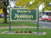 Following the release of Peter Jackson
's Lord of the Rings movies
, New Zealand has sometimes been called "Middle-earth" after the fictional setting
of the films. Wellington
, the centre of the films' production, was sometimes called Middle-earth, and for about a week around the release of the first movie the local newspaper The Evening Post renamed itself to The Middle Earth Post. The town of Matamata
, near the location of many of the Hobbiton scenes, unofficially renamed itself "Hobbiton". The flourishing of the film-industry in Wellington has led to the nickname "Wellywood
", and a proposal to erect a "Hollywood" style sign near the airport was overturned due to public resistance and possible copyright infringements.
A number of towns have acquired ironic nicknames comparing them to the "more exciting" city of Las Vegas
; "Rotovegas" for Rotorua
, "Ashvegas" for Ashburton
and "Invervegas" for Invercargil. Other areas have nicknames or popular designations based on abbreviations or mangling of the Māori name. New Zealanders will sometimes refer to the Taranaki Region as "The Naki", Palmerston North
as "Palmy", Gisborne as "Gizzie", Cardrona
as "Cardie", Paraparaumu
as "Paraparam", Waimakariri
as "Waimak" and Paekakariki
as "Pie-cock".
United Kingdom
The United Kingdom of Great Britain and Northern IrelandIn the United Kingdom and Dependencies, other languages have been officially recognised as legitimate autochthonous languages under the European Charter for Regional or Minority Languages...
sources. Both groups used names to commemorate notable people, events, places from their homeland, their ships or to described the surrounding area. The Māori did not have a collective name for New Zealand
New Zealand
New Zealand is an island country in the south-western Pacific Ocean comprising two main landmasses and numerous smaller islands. The country is situated some east of Australia across the Tasman Sea, and roughly south of the Pacific island nations of New Caledonia, Fiji, and Tonga...
before European arrival, but post-colonisation the name Aotearoa
Aotearoa
Aotearoa is the most widely known and accepted Māori name for New Zealand. It is used by both Māori and non-Māori, and is becoming increasingly widespread in the bilingual names of national organisations, such as the National Library of New Zealand / Te Puna Mātauranga o Aotearoa.-Translation:The...
(commonly translated as 'long white cloud') was used to refer to the whole country. Dutch cartographers named the islands Nova Zeelandia and British explorer James Cook
James Cook
Captain James Cook, FRS, RN was a British explorer, navigator and cartographer who ultimately rose to the rank of captain in the Royal Navy...
subsequently anglicised the name to New Zealand. The two main islands are known simply as the North
North Island
The North Island is one of the two main islands of New Zealand, separated from the much less populous South Island by Cook Strait. The island is in area, making it the world's 14th-largest island...
and South Island
South Island
The South Island is the larger of the two major islands of New Zealand, the other being the more populous North Island. It is bordered to the north by Cook Strait, to the west by the Tasman Sea, to the south and east by the Pacific Ocean...
s, although those names have never been formalised.
Many of the early Māori names were replaced by Europeans during the late 18th and early 19th century. Government amendments
Amend (motion)
-Explanation and Use:-Main Motions:Any main motion and any motion to amend may be amended. However, a motion to amend a motion to amend may not be amended, due to the overly complex parliamentary situation that would frequently result.-Secondary Motions:...
in 1894 and the establishment of the New Zealand Geographic Board
New Zealand Geographic Board
The New Zealand Geographic Board is constituted under the New Zealand Geographic Board Act 2008, formerly under the New Zealand Geographic Board Act 1946. Although an independent institution, it is responsible to the Minister for Land Information...
in the mid 1940s led to the encouragement of original Māori names, although incorrect spellings and pronunciations persisted. Many names now have alternative or dual
Dual naming
Dual naming is a policy for the naming of geographical landmarks, in which an official name is adopted that combines two previous names. Usually, the context is a conflict over which of the two previous names is most appropriate....
English and Maori names or, in a few rare cases, dual Māori names or dual English names. Most names have never been made official and if they are mentioned in authoritative publications they are considered recorded names. Colloquial names in New Zealand result from an ironic view of the places entertainment value, plays on advertising mottos, or are shortened versions of the full name. Some places tried to capitalise on the success of the Lord of the Rings
The Lord of the Rings film trilogy
The Lord of the Rings is an epic film trilogy consisting of three fantasy adventure films based on the three-volume book of the same name by English author J. R. R. Tolkien. The films are The Fellowship of the Ring , The Two Towers and The Return of the King .The films were directed by Peter...
films by linking themselves to the movies.
Country and main islands
No known pre-contact Māori name for New Zealand as a whole survives, although Māori had several names for the NorthNorth Island
The North Island is one of the two main islands of New Zealand, separated from the much less populous South Island by Cook Strait. The island is in area, making it the world's 14th-largest island...
and South Island
South Island
The South Island is the larger of the two major islands of New Zealand, the other being the more populous North Island. It is bordered to the north by Cook Strait, to the west by the Tasman Sea, to the south and east by the Pacific Ocean...
; including Te Ika a Māui (the fish of Māui
Maui (Maori mythology)
In Māori mythology, Māui is a culture hero famous for his exploits and his trickery.-Māui's birth:The offspring of Tū increased and multiplied and did not know death until the generation of Māui-tikitiki . Māui is the son of Taranga, the wife of Makeatutara...
) for the North Island and Te Wai Pounamu
Te Wai Pounamu
Te Wai Pounamu is a Māori name for New Zealand's South Island which is also sometimes referred to as Te Waka a Maui , from mythology....
(the waters of greenstone) or Te Waka o Aoraki (the canoe of Aoraki) for the South Island
South Island
The South Island is the larger of the two major islands of New Zealand, the other being the more populous North Island. It is bordered to the north by Cook Strait, to the west by the Tasman Sea, to the south and east by the Pacific Ocean...
. Until the early 20th century, Māori also referred to the North Island as Aotearoa
Aotearoa
Aotearoa is the most widely known and accepted Māori name for New Zealand. It is used by both Māori and non-Māori, and is becoming increasingly widespread in the bilingual names of national organisations, such as the National Library of New Zealand / Te Puna Mātauranga o Aotearoa.-Translation:The...
, (commonly translated as 'long white cloud'); in modern Māori usage this has become the name for the whole country.
The first European visitor to New Zealand, Dutch
Netherlands
The Netherlands is a constituent country of the Kingdom of the Netherlands, located mainly in North-West Europe and with several islands in the Caribbean. Mainland Netherlands borders the North Sea to the north and west, Belgium to the south, and Germany to the east, and shares maritime borders...
explorer Abel Tasman
Abel Tasman
Abel Janszoon Tasman was a Dutch seafarer, explorer, and merchant, best known for his voyages of 1642 and 1644 in the service of the VOC . His was the first known European expedition to reach the islands of Van Diemen's Land and New Zealand and to sight the Fiji islands...
, named the islands Staten Landt, believing it formed part of the land
Isla de los Estados
Isla de los Estados is an Argentine island that lies off the eastern extremity of the Argentine portion of Tierra del Fuego, from which it is separated by the Le Maire Strait...
which Jacob Le Maire
Jacob Le Maire
Jacob Le Maire was a Dutch mariner who circumnavigated the earth in 1615-16. The strait between Tierra del Fuego and Isla de los Estados was named the Le Maire Strait in his honor, though not without controversy...
had seen off the coast of Tierra del Fuego
Tierra del Fuego
Tierra del Fuego is an archipelago off the southernmost tip of the South American mainland, across the Strait of Magellan. The archipelago consists of a main island Isla Grande de Tierra del Fuego divided between Chile and Argentina with an area of , and a group of smaller islands including Cape...
. Hendrik Brouwer
Hendrik Brouwer
Hendrik Brouwer was a Dutch explorer, admiral, and colonial administrator both in Japan and the Dutch East Indies....
proved the supposedly South American land an island in 1643, and Dutch cartographers subsequently renamed Tasman's discovery to Nova Zeelandia, after the Dutch province of Zeeland
Zeeland
Zeeland , also called Zealand in English, is the westernmost province of the Netherlands. The province, located in the south-west of the country, consists of a number of islands and a strip bordering Belgium. Its capital is Middelburg. With a population of about 380,000, its area is about...
. The Latin
Latin
Latin is an Italic language originally spoken in Latium and Ancient Rome. It, along with most European languages, is a descendant of the ancient Proto-Indo-European language. Although it is considered a dead language, a number of scholars and members of the Christian clergy speak it fluently, and...
Nova Zeelandia became Nieuw Zeeland in Dutch
Dutch language
Dutch is a West Germanic language and the native language of the majority of the population of the Netherlands, Belgium, and Suriname, the three member states of the Dutch Language Union. Most speakers live in the European Union, where it is a first language for about 23 million and a second...
and British explorer James Cook
James Cook
Captain James Cook, FRS, RN was a British explorer, navigator and cartographer who ultimately rose to the rank of captain in the Royal Navy...
subsequently called the archipelago New Zealand, using the anglicised form of the Dutch name.
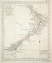
The 1840 Letters Patent
Letters patent
Letters patent are a type of legal instrument in the form of a published written order issued by a monarch or president, generally granting an office, right, monopoly, title, or status to a person or corporation...
established New Zealand as a British colony and claimed the "principal islands" of New Zealand, identified by their commonly-known names at the time: the Northern Island (the North Island), the Middle Island (the South Island) and Stewart's Island or "South Island". The letters patent attempted to rename the islands to New Ulster
New Ulster
New Ulster was the name of a province of New Zealand that existed between 1841 and 1853.-Original province:Between 1841 and 1846 the province included all the North Island north of the Patea River. With the passing of the New Zealand Constitution Act 1846, the province came to include all of the...
, New Munster and New Leinster
New Leinster
New Leinster was a province of New Zealand, consisting of Stewart Island/Rakiura named after the Irish province of Leinster.Governor William Hobson named the North Island New Ulster, the South Island New Munster and Stewart Island/Rakiura New Leinster after the correspondence regions in Ireland in...
after the provinces in Ireland. New Ulster, New Munster and New Leinster were also used for the initial provinces of New Zealand
Provinces of New Zealand
The Provinces of New Zealand existed from 1841 until 1876 as a form of sub-national government. They were replaced by counties, which were themselves replaced by districts.Following abolition, the provinces became known as provincial districts...
, but the names did not endure. In the 1830s the South Island was used as an alternative to Middle Island and by 1907 it became the common name. The North and South Island names arose through common usage rather than official decleration and in 2009 it was revealed that they had never been formalised.
Māori names
Hawaiki
In Māori mythology, Hawaiki is the homeland of the Māori, the original home of the Māori, before they travelled across the sea to New Zealand...
names or myths. After European arrival many locations became known as Māori versions of European words or poorly pronounced contractions of the original Māori names.
Early Māori explorers Kupe
Kupe
In the Māori mythology of some tribes, Kupe was involved in the Polynesian discovery of New Zealand.-Contention:There is contention concerning the status of Kupe. The contention turns on the authenticity of later versions of the legends, the so-called 'orthodox' versions closely associated with S....
, Ngahue
Ngahue
According to Maori mythology Ngahue was a contemporary of Kupe and one of the first Polynesian explorers to reach New Zealand. He was a native of the Hawaiki and voyaged to New Zealand in “Tāwhirirangi”, his waka...
, and Toi
Toi (name)
Toi is a fairly common man's name in Māori and other Polynesian languages.The best known men named Toi are the following from Māori legendary history, who are sometimes confused with one another:...
, named many of New Zealand's coastal features. Like later European explorers, they named things after themselves, their family-members and events that occurred at the newly-discovered location. Kahumatamomoe
Kahumatamomoe
Kahumatamomoe is an early Maori explorer. He travelled with his nephew Ihenga from Rotorua to Kaipara Harbour and then alone around the Coromandel Peninsula and back to Rotorua. Lake Rotoruas full name is Te Rotoruanui-a-Kahumatamomoe and was named by Ihenga to honour his uncle....
named Manukau Harbour
Manukau Harbour
Manukau Harbour is the second largest natural harbour in New Zealand by area. It is located to the southwest of the Auckland isthmus, and is an arm of the Tasman Sea.-Geography:...
after a manuka
Leptospermum scoparium
Leptospermum scoparium is a shrub or small tree native to New Zealand and southeast Australia. Evidence suggests that L. scoparium originated in Australia before the onset of the Miocene aridity and dispersed relatively recently from Eastern Australia to New Zealand. It is likely that on arrival...
-stake that he used to claim ownership of the area, and Kaipara Harbour
Kaipara Harbour
Kaipara Harbour is a large enclosed harbour estuary complex on the north western side of the North Island of New Zealand. The northern part of the harbour is administered by the Kaipara District and the southern part is administered by the Rodney District...
after the para fern he ate there (kai means food). The Māori name for Wellington Harbour
Wellington Harbour
Wellington Harbour is the large natural harbour at the southern tip of New Zealand's North Island. New Zealand's capital, Wellington, is on the western side of Wellington Harbour. The harbour was officially named Port Nicholson until it assumed its current name in the 1980s.In Māori the harbour is...
, Te Whanganui a Tara, derives from Tara, a grandson of Kupe and ancestor of several local iwi
Iwi
In New Zealand society, iwi form the largest everyday social units in Māori culture. The word iwi means "'peoples' or 'nations'. In "the work of European writers which treat iwi and hapū as parts of a hierarchical structure", it has been used to mean "tribe" , or confederation of tribes,...
. Names from other islands visited during the "Great Migration"
Maori migration canoes
Various Māori traditions recount how their ancestors set out from their homeland in great ocean-going canoes . Some of these traditions name a mythical homeland called Hawaiki....
have been used to identify some New Zealand landmarks, for example Raratoka Island
Raratoka Island
Raratoka Island is a small island in Foveaux Strait off the coast of Stewart Island / Rakiura, New Zealand. It is located north of Stewart island's northernmost point, Black Rock Point, and southwest of the Southland town of Riverton on the South Island mainland...
(from Rarotonga
Rarotonga
Rarotonga is the most populous island of the Cook Islands, with a population of 14,153 , out of the country's total population of 19,569.The Cook Islands' Parliament buildings and international airport are on Rarotonga...
) and Tawhiti (from Tahiti
Tahiti
Tahiti is the largest island in the Windward group of French Polynesia, located in the archipelago of the Society Islands in the southern Pacific Ocean. It is the economic, cultural and political centre of French Polynesia. The island was formed from volcanic activity and is high and mountainous...
). Whakatane
Whakatane
Whakatane is a town in the eastern Bay of Plenty Region, in the North Island of New Zealand, and is the seat of the Bay of Plenty Regional Council. Whakatane is 90 km east of Tauranga and 89 km north-east of Rotorua, at the mouth of the Whakatane River.The town has a population of , with...
, Rangitoto, Taupo
Taupo
Taupo is a town on the shore of Lake Taupo in the centre of the North Island of New Zealand. It is the seat of the Taupo District Council and lies in the southern Waikato Region....
, Urewera
Te Urewera
Te Urewera is an area of the central North Island of New Zealand. Located in rough, sparsely populated hill country to the northeast of Lake Taupo, it is the historical home of Tuhoe, a Māori iwi known for their controversial stance on Māori sovereignty...
, Ngongotaha
Ngongotaha
Ngongotaha is a town on the western shores of Lake Rotorua in New Zealand's North Island.It is located 10 kilometers northwest of Rotorua city, and is often regarded as an outer suburb of the larger centre. However, most locals would be adamant that Ngongotaha is an independent village in its own...
, and Tikitapu
Lake Tikitapu
Lake Tikitapu or Blue Lake, is the smallest of four small lakes lying between Lake Rotorua and Lake Tarawera in the Bay of Plenty region of New Zealand's North Island. The others are Lake Rotokakahi , Lake Okareka, and Lake Okataina....
all commemorate incidents that occurred during the early arrivals, many of which are now forgotten.
Maketu
Maketu
Maketu is a small town on the Bay of Plenty Coast in New Zealand. It is located on Okurei point and has an estuary from which the Kaituna River used to flow out of, it is also adjacent to Newdicks Beach located on the south eastern side of Okurei point. The name is sometimes informally abbreviated...
and Mount Moehau
Moehau Range
The Moehau Range is the northernmost range on the Coromandel Peninsula, extending from the settlement of Colville northwards to the tip of the peninsula. Mt Moehau is the highest point of the range, at 892m above sea level.-Physical Geography:...
are two of the few remaining names connected to places in Hawaiki. The use of Polynesian mythology in names is more apparent, with Tāne
Tane
In Māori mythology, Tāne is the god of forests and of birds, and the son of Ranginui and Papatuanuku, the sky father and the earth mother, who lie in a tight embrace...
(the forest god) lending his name to Otane
Otane
Otane is a township in the Central Hawke's Bay District on the east coast of the North Island of New Zealand.It is a small village, with a school, general store, cafe and pub.-External links:*...
and Taneatua
Taneatua
Taneatua is a small town in the Bay of Plenty region of New Zealand's North Island. It is officially defined as a "populated area less than a town". The 2001 New Zealand Census of Population and Dwellings found its population to be 750, a 14.7% decline since the previous census in 1996...
among others. Descriptive words are often used as part of a place name, with Ara (road), Maunga (mountain), Wai (water), Whanga (bay), Roto (lake) and nui (big) among some of the more widely used. Whanganui
Whanganui
Various places in New Zealand are called Whanganui:*Whanganui, a city at the mouth of the Whanganui River, also often spelled "Wanganui", Manawatu-Wanganui Region*Whanganui District, Manawatu-Wanganui Region*Whanganui Island, Waikato Region...
means "wide river-mouth" and Waikanae
Waikanae
Waikanae is a small town on New Zealand's Kapiti Coast. The name is a Māori word meaning "The waters of the yellow eyed mullet". Another settlement called Waikanae Beach exists near Gisborne on the east coast of the North Island of New Zealand....
indicates good waters for catching kanae, or flathead mullet
Flathead mullet
The flathead mullet, Mugil cephalus, is a mullet of the genus Mugil, found in coastal tropical and subtropical waters worldwide. Its length is typically 30 to 75 centimeters...
. European arrival exposed Māori to Christianity, leading to the settlements of Hiruharama
Jerusalem, New Zealand
Jerusalem was once an important kainga on the Whanganui River in New Zealand where a Roman Catholic mission was first established in 1854....
, Petane
Bay View, New Zealand
Bay View is a settlement in the Hawke's Bay Region of the eastern North Island of New Zealand. It lies on State Highway 2 nine kilometres north of the centre of Napier. The area was previously known as Petane and was seized by Maori in the early 1860's with the idea of attacking Napier.-References:...
and Hamaria
Hallett's Bay, New Zealand
Hallett's Bay is a bay on the eastern shore of Lake Taupo, New Zealand. It was known as Hameria, named after Samaria during missionary times, and before that Paka. The early Maori explorer Tia built a tūāhu to signify he occupied the land and named the cliffs Taupō-nui-a-Tia...
being named after the biblical Jerusalem, Bethany
Bethany
Bethany, in the Bible, was the name of a village near Jerusalem - see Bethany - mentioned in the New Testament as the home of the siblings Mary, Martha, and Lazarus and, according to the Gospel of John, the site of a miracle in which Jesus raises Lazarus from the dead...
and Samaria
Samaria
Samaria, or the Shomron is a term used for a mountainous region roughly corresponding to the northern part of the West Bank.- Etymology :...
. The Ranana
Ranana
Rānana is a settlement 60 km from Whanganui along the Whanganui River. It was named by the missionary Richard Taylor in the 19th century and is a Maori transliteration of London....
, Atene
Atene
Ātene is a former village located from Whanganui along the Whanganui River. It was named by the missionary Richard Taylor in the 19th century and is a Maori transliteration of Athens. A small meeting house is all that remains....
and Karaponia settlements are Māori transliterations of London
London
London is the capital city of :England and the :United Kingdom, the largest metropolitan area in the United Kingdom, and the largest urban zone in the European Union by most measures. Located on the River Thames, London has been a major settlement for two millennia, its history going back to its...
, Athens
Athens
Athens , is the capital and largest city of Greece. Athens dominates the Attica region and is one of the world's oldest cities, as its recorded history spans around 3,400 years. Classical Athens was a powerful city-state...
and California
California
California is a state located on the West Coast of the United States. It is by far the most populous U.S. state, and the third-largest by land area...
. Moriori
Moriori
Moriori are the indigenous people of the Chatham Islands , east of the New Zealand archipelago in the Pacific Ocean...
, descendants of Maori, migrated to islands off the eastern coast of New Zealand and named them Rēkohu (Misty Sun). Sometime before 1835 Māori settled at Rēkohu and confused the name of the settlement, Wharekauri, for the name of islands. It has been known as Wharekauri to Māori ever since.
Post-colonial recognition
Early Europeans displaced most of the original Māori names with their own, although some persisted in the north and central regions of the North Island. The Royal Geographical Society of London was responsible for place names until 1894 when authority was given to the New Zealand Governor-GeneralGovernor-General
A Governor-General, is a vice-regal person of a monarch in an independent realm or a major colonial circonscription. Depending on the political arrangement of the territory, a Governor General can be a governor of high rank, or a principal governor ranking above "ordinary" governors.- Current uses...
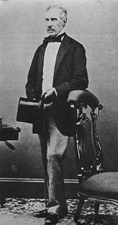
. Prime Minister Joseph Ward
Joseph Ward
Sir Joseph George Ward, 1st Baronet, GCMG was the 17th Prime Minister of New Zealand on two occasions in the early 20th century.-Early life:...
moved an amendment
Amend (motion)
-Explanation and Use:-Main Motions:Any main motion and any motion to amend may be amended. However, a motion to amend a motion to amend may not be amended, due to the overly complex parliamentary situation that would frequently result.-Secondary Motions:...
in 1894 that gave preference to Māori names for any new features and allowed misspelt names to be altered (although this did not always occur). In 1924 the Honorary Geographic Board of New Zealand was set up to advise on place names, and in 1946 the New Zealand Geographic Board
New Zealand Geographic Board
The New Zealand Geographic Board is constituted under the New Zealand Geographic Board Act 2008, formerly under the New Zealand Geographic Board Act 1946. Although an independent institution, it is responsible to the Minister for Land Information...
(NZGB) was established and given power to change or implement Māori and English names. Anyone can propose a geographical name to the board, who consult local Māori and allow public submissions before determining if the name should be made official. Names can also be made official through an Act of Parliament
Act of Parliament
An Act of Parliament is a statute enacted as primary legislation by a national or sub-national parliament. In the Republic of Ireland the term Act of the Oireachtas is used, and in the United States the term Act of Congress is used.In Commonwealth countries, the term is used both in a narrow...
and the NZGB is required to keep a keep a public list of all the official New Zealand geographical names.
The NZGB encourages the use of original Māori names and has given some places official double names. These can be expressed as alternative names where officially either name could be used (Mount Taranaki or Mount Egmont) or dual names where both names should be used together (Matiu / Somes Island). In 1998, as a result of the settling of the Ngai Tahu
Ngai Tahu
Ngāi Tahu, or Kāi Tahu, is the principal Māori iwi of the southern region of New Zealand, with the tribal authority, Te Rūnanga o Ngāi Tahu, being based in Christchurch and Invercargill. The iwi combines three groups, Kāi Tahu itself, and Waitaha and Kāti Mamoe who lived in the South Island prior...
Treaty claim
Treaty of Waitangi claims and settlements
Treaty of Waitangi claims and settlements have been a significant feature of New Zealand race relations and politics since 1975. Over the last 30 years, New Zealand governments have increasingly provided formal legal and political opportunity for Māori to seek redress for breaches by the Crown of...
, New Zealand's tallest mountain, officially became Aoraki / Mount Cook. There are also a few English dual names, with Wellington harbour
Wellington Harbour
Wellington Harbour is the large natural harbour at the southern tip of New Zealand's North Island. New Zealand's capital, Wellington, is on the western side of Wellington Harbour. The harbour was officially named Port Nicholson until it assumed its current name in the 1980s.In Māori the harbour is...
also officially known as Port Nicholson. The New Zealand Geographic Board is currently looking for alternative Māori names to use alongside the North and South Island names. Te Ika-a-Māui and Te Wai Pounamu are seen as the most likely choices by the chairman of the Māori Language Commission
Maori Language Commission
New Zealand's Māori Language Commission is an autonomous crown entity set up under the Māori Language Act 1987 with the following functions:...
.
Māori groups have campaigned to correct inaccurately spelled or pronounced Māori language
Maori language
Māori or te reo Māori , commonly te reo , is the language of the indigenous population of New Zealand, the Māori. It has the status of an official language in New Zealand...
place-names. In 2000, the local iwi suggestion to rename the Wellington suburb of Hataitai
Hataitai
Hataitai is an inner-city suburb of Wellington, the capital of New Zealand, 3.5 kilometres southeast of the city centre. The suburb extends over the southeastern flank of Mount Victoria and down a valley between the Town Belt and a ridge along the shoreline of Evans Bay...
to Whataitai, referring to a taniwha
Taniwha
In Māori mythology, taniwha are beings that live in deep pools in rivers, dark caves, or in the sea, especially in places with dangerous currents or deceptive breakers...
(sea-monster) that legend says lived in Wellington Harbour, was declined by the Geographic Board. More recently the New Zealand Geographical Board recommended renaming the town of Wanganui to Whanganui
Whanganui
Various places in New Zealand are called Whanganui:*Whanganui, a city at the mouth of the Whanganui River, also often spelled "Wanganui", Manawatu-Wanganui Region*Whanganui District, Manawatu-Wanganui Region*Whanganui Island, Waikato Region...
as the town was originally named after the Whanganui River
Whanganui River
The Whanganui River is a major river in the North Island of New Zealand.Known for many years as the Wanganui River, the river's name reverted to Whanganui in 1991, according with the wishes of local iwi. Part of the reason was also to avoid confusion with the Wanganui River in the South Island...
and the word wanga is not in the Māori lexicon
Lexicon
In linguistics, the lexicon of a language is its vocabulary, including its words and expressions. A lexicon is also a synonym of the word thesaurus. More formally, it is a language's inventory of lexemes. Coined in English 1603, the word "lexicon" derives from the Greek "λεξικόν" , neut...
. The government decided in 2009 that both Whanganui and Wanganui would be accepted as alternative official names. The origin of Wanganui has been claimed to reflect the dialect
Dialect
The term dialect is used in two distinct ways, even by linguists. One usage refers to a variety of a language that is a characteristic of a particular group of the language's speakers. The term is applied most often to regional speech patterns, but a dialect may also be defined by other factors,...
al pronunciation of local Māori, who pronounce 'wh' (an "f"-like sound in other dialects) as [ˀw] – a glottalised
Glottal stop
The glottal stop, or more fully, the voiceless glottal plosive, is a type of consonantal sound used in many spoken languages. In English, the feature is represented, for example, by the hyphen in uh-oh! and by the apostrophe or [[ʻokina]] in Hawaii among those using a preservative pronunciation of...
"w".
European names
Golden Bay
Golden Bay lies at the edge of the junction between the Tasman Sea and Cook Strait. It stretches for 45 kilometres from the long sand spit of Farewell Spit in the north to Separation Point in Abel Tasman National Park at its southern extremity...
did not last, while some like Cape Maria van Diemen
Cape Maria van Diemen
Cape Maria van Diemen is the westernmost point of the North Island of New Zealand. Being close to the northern tip of the Aupouri Peninsula, many people in New Zealand also incorrectly believe it to be the northernmost point...
(the wife of the governor of Batavia
Jakarta
Jakarta is the capital and largest city of Indonesia. Officially known as the Special Capital Territory of Jakarta, it is located on the northwest coast of Java, has an area of , and a population of 9,580,000. Jakarta is the country's economic, cultural and political centre...
) and Three Kings Islands
Three Kings Islands
The Three Kings Islands or Manawa Islands are a group of 13 islands about northwest of Cape Reinga, the northernmost point of the North Island of New Zealand, where the South Pacific Ocean and Tasman Sea converge. They measure about 4.86 km² in area...
are still in use. Cook named many more on his voyage, including Bay of Islands
Bay of Islands
The Bay of Islands is an area in the Northland Region of the North Island of New Zealand. Located 60 km north-west of Whangarei, it is close to the northern tip of the country....
, Bay of Plenty
Bay of Plenty
The Bay of Plenty , often abbreviated to BOP, is a region in the North Island of New Zealand situated around the body of water of the same name...
, Poverty Bay
Poverty Bay
Poverty Bay is the largest of several small bays on the east coast of New Zealand's North Island to the north of Hawkes Bay. It stretches for 10 kilometres from Young Nick's Head in the southwest to Tuaheni Point in the northeast. The city of Gisborne is located on the northern shore of the bay...
, Cape Farewell
Cape Farewell, New Zealand
thumb|right|Clifftop walk, looking northeast.Cape Farewell is a headland in New Zealand, the most northerly point on the South Island. It is located just west of Farewell Spit...
, Queen Charlotte Sound
Queen Charlotte Sound, New Zealand
Queen Charlotte Sound is the easternmost of the main sounds of the Marlborough Sounds, in New Zealand's South Island. It is, like the other sounds, a drowned river valley , and like the majority of its neighbours it runs southwest to northeast before joining Cook Strait.The town of Picton, the...
, Mount Egmont and Banks Peninsula
Banks Peninsula
Banks Peninsula is a peninsula of volcanic origin on the east coast of the South Island of New Zealand. It has an area of approximately and encompasses two large harbours and many smaller bays and coves...
. Cape Kidnappers
Cape Kidnappers
Cape Kidnappers is a headland at the southeastern extremity of Hawke Bay on the east coast of New Zealand's North Island. It is located 20 kilometres southeast of the city of Napier...
commemorates a Māori attempt to kidnap one of Cook's crew members. Dumont d’Urville named French Pass
French Pass
French Pass is a narrow and treacherous stretch of water that separates D'Urville Island, at the north end of the South Island of New Zealand, from the mainland coast. At one end is Tasman Bay, and at the other end the outer Pelorus Sound leads out to Cook Strait.French Pass has the fastest tidal...
after sailing through it. The explorers lent their names to many places, including Mount Tasman
Mount Tasman
Mount Tasman is New Zealand's second highest mountain, rising to a height of 3497 metres. It is located in the Southern Alps of the South Island, four kilometres to the north of its larger neighbour, Aoraki/Mount Cook...
, Tasman Glacier
Tasman Glacier
The Tasman Glacier is the largest of several glaciers which flow south and east towards the Mackenzie Basin from the Southern Alps in New Zealand's South Island. It is New Zealand's longest glacier.-Geography:...
, the Tasman Region, Cook Strait
Cook Strait
Cook Strait is the strait between the North and South Islands of New Zealand. It connects the Tasman Sea on the west with the South Pacific Ocean on the east....
, Mount Cook and d’Urville Island. The Coromandel
HMS Malabar (1804)
HMS Malabar was a 56-gun fourth rate of the Royal Navy. She had previously been the East Indiaman Cuvera, which the Navy bought in 1804. The Navy converted her to a storeship in 1806. After being renamed HMS Coromandel she became a convict ship and made a trip carrying convicts to New South Wales...
, Chatham
HMS Chatham (1788)
HMS Chatham was a Royal Navy survey brig that accompanied HMS Discovery on George Vancouver's exploration of the west coast of North America in his 1791–1795 expedition. Chatham was built by King, of Dover and launched in early 1788...
and Pegasus ships visited New Zealand's shores between 1791 and 1820 and were used to name Coromandel Peninsula
Coromandel Peninsula
The Coromandel Peninsula lies in the North Island of New Zealand. It is part of the Waikato Region and Thames-Coromandel District and extends 85 kilometres north from the western end of the Bay of Plenty, forming a natural barrier to protect the Hauraki Gulf and the Firth of Thames in the west...
, Chatham Islands
Chatham Islands
The Chatham Islands are an archipelago and New Zealand territory in the Pacific Ocean consisting of about ten islands within a radius, the largest of which are Chatham Island and Pitt Island. Their name in the indigenous language, Moriori, means Misty Sun...
, Pegasus Bay
Pegasus Bay
Pegasus Bay is on the east coast of the South Island of New Zealand.-Location:The bay has a sandy beach and runs from Banks Peninsula to the Waipara River mouth...
and Port Pegasus
Port Pegasus
Port Pegasus is located at the southern end of Stewart Island in New Zealand. From the 1890s to the 1950s, Port Pegasus was the site of a small fishing community. There was also a small tin-mining boom in the area in the 1890s...
. Stewart Island was named after the first officer aboard the Pegasus.
Most European names came during the 1840s to the 1910s and were given by surveyors who worked for colonising associations or provincial governments. Names acknowledged the colonising associations sponsors (Hutt Valley
Hutt Valley, New Zealand
The Hutt Valley is the large area of fairly flat land in the Hutt River valley in the Wellington region of New Zealand. Like the river that flows through it, it takes its name from Sir William Hutt, a director of the New Zealand Company in early colonial New Zealand.The river flows roughly along...
, Wakefield
Wakefield, New Zealand
The small New Zealand community of Wakefield is situated some 25 km south west of Nelson at the top of the South Island.First settled in about 1843, it was originally called Pitfure. However the name was soon changed to Wakefield...
, Port Chalmers
Port Chalmers
Port Chalmers is a suburb and the main port of the city of Dunedin, New Zealand, with a population of 3,000. Port Chalmers lies ten kilometres inside Otago Harbour, some 15 kilometres northeast from Dunedin's city centre....
, Ashburton
Ashburton, New Zealand
Ashburton is a town and district in the Canterbury Region on the east coast of the South Island of New Zealand. It is the third-largest centre in Canterbury, after Christchurch and Timaru. The area around Ashburton is frequently referred to as Mid Canterbury, which is also the name of the...
), ships (Bombay), government officials (Featherston
Featherston, New Zealand
Featherston is a town in the north of the Wellington Region region of New Zealand. It lies in the Wairarapa, just north of the Rimutaka Tunnel, in the South Wairarapa District. The population was 2,340 in the 2006 Census....
, Rolleston
Rolleston, New Zealand
Rolleston is a town in the Selwyn District of Canterbury, New Zealand.It is located next to State Highway 1, 22 km south-west of Christchurch on the Canterbury Plains in the South Island of New Zealand. The town uses the slogan "The Town of the Future"...
, Invercargill
Invercargill
Invercargill is the southernmost and westernmost city in New Zealand, and one of the southernmost cities in the world. It is the commercial centre of the Southland region. It lies in the heart of the wide expanse of the Southland Plains on the Oreti or New River some 18 km north of Bluff,...
), politicians (Foxton
Foxton, New Zealand
Foxton is a town in the Manawatu-Wanganui region of New Zealand. The 2006 census population was 2715.It is located on the lower west coast of the North Island, in the Horowhenua district, 30 kilometres southwest of Palmerston North and 15 kilometres north of Levin. The town is located close to the...
, Fox Glacier
Fox Glacier
The Fox Glacier is a long glacier located in Westland Tai Poutini National Park on the West Coast of New Zealand's South Island...
, Gisborne
Gisborne, New Zealand
-Economy:The harbour was host to many ships in the past and had developed as a river port to provide a more secure location for shipping compared with the open roadstead of Poverty Bay which can be exposed to southerly swells. A meat works was sited beside the harbour and meat and wool was shipped...
) and church leaders (Selwyn
Selwyn District
The Selwyn District is a predominantly rural area in central Canterbury, on the east coast of New Zealand's South Island. It is named after the Selwyn River, which is in turn named after Bishop George Selwyn, the first Anglican bishop of New Zealand who, in 1843 and 1844, travelled the length of...
). Military heroes and famous battles were popular place names, with Auckland
Auckland
The Auckland metropolitan area , in the North Island of New Zealand, is the largest and most populous urban area in the country with residents, percent of the country's population. Auckland also has the largest Polynesian population of any city in the world...
, Napier
Napier, New Zealand
Napier is a New Zealand city with a seaport, located in Hawke's Bay on the eastern coast of the North Island. The population of Napier is about About 18 kilometres south of Napier is the inland city of Hastings. These two neighboring cities are often called "The Twin Cities" or "The Bay Cities"...
, Hastings
Hastings, New Zealand
The city of Hastings is a major urban settlement in the Hawke's Bay region of the North Island of New Zealand, and it is the largest settlement by population in Hawke's Bay. Hastings city is the administrative centre of the Hastings District...
, Havelock
Havelock, New Zealand
Havelock is a coastal village in the Marlborough region of New Zealand. It sits at the head of Pelorus Sound, one of the Marlborough Sounds. The population was 486 in the 2006 Census, an increase of 12 from 2001....
, Wellington
Wellington
Wellington is the capital city and third most populous urban area of New Zealand, although it is likely to have surpassed Christchurch due to the exodus following the Canterbury Earthquake. It is at the southwestern tip of the North Island, between Cook Strait and the Rimutaka Range...
, Picton
Picton, New Zealand
Picton is a town in the Marlborough region of New Zealand. It is close to the head of Queen Charlotte Sound near the north-east corner of the South Island. The population was 2928 in the 2006 Census, a decrease of 72 from 2001...
, Marlborough, Nelson
Nelson, New Zealand
Nelson is a city on the eastern shores of Tasman Bay, and is the economic and cultural centre of the Nelson-Tasman region. Established in 1841, it is the second oldest settled city in New Zealand and the oldest in the South Island....
and Blenheim
Blenheim, New Zealand
Blenheim is the most populous town in the region of Marlborough, in the north east of the South Island of New Zealand, and the seat of the regional council. It has a population of The area which surrounds the town is well known as a centre of New Zealand's wine industry...
. British politicians and royalty lent their names to Russell
Russell, New Zealand
Russell, formerly known as Kororareka, was the first permanent European settlement and sea port in New Zealand. It is situated in the Bay of Islands, in the far north of the North Island. As at the 2006 census it had a resident population of 816, an increase of 12 from 2001...
, Palmerston
Palmerston, New Zealand
The town of Palmerston, in New Zealand's South Island lies 50 kilometres to the north of the city of Dunedin. It is the largest town in the Waihemo Ward of the Waitaki District with a population of 890 residents...
, Cromwell
Cromwell, New Zealand
Cromwell is a town in Central Otago in the Otago region of New Zealand.It is situated between State Highway 6 and State Highway 8 leading to the Lindis Pass, 75 km northeast, and Alexandra, 33 km south. The road to Alexandra winds through the Cromwell Gorge...
, Queenstown
Queenstown, New Zealand
Queenstown is a resort town in Otago in the south-west of New Zealand's South Island. It is built around an inlet called Queenstown Bay on Lake Wakatipu, a long thin Z-shaped lake formed by glacial processes, and has spectacular views of nearby mountains....
and Alexandra
Alexandra, New Zealand
Alexandra is a town in the Central Otago district of the Otago region of New Zealand. It is located on the banks of the Clutha River , on State Highway 8, 188 km by road from Dunedin and 33 km south of Cromwell.At the time of the 2006 census, the permanent population was 4,827, an...
, while Franz Josef
Franz Josef, New Zealand
Franz Josef is a small town in the West Coast region of the South Island of New Zealand. Whataroa is 32 km to the north-east, and the township of Fox Glacier is 23 km to the south-west. State Highway 6 runs through the town...
is named after the Austrian emperor. Royal names are more popular for streets than towns or geographical features, although both Auckland
Mount Victoria, Auckland
Mount Victoria is the highest volcano on Auckland's North Shore, rising to 87 m. Its age is currently unknown. Its lava flows now line much of Devonport's waterfront...
and Wellington have Mount Victoria
Mount Victoria, Wellington
Mount Victoria, locally abbreviated to Mt. Vic, is a prominent hill to the east of the centre of Wellington, New Zealand, and its associated suburb. To the south of it is a spur, Mount Albert, and the two are linked by a ridge....
. Gore
Gore, New Zealand
Gore is a town, surrounding borough, and district in the Southland region of the South Island of New Zealand.-Geography:The Gore District has a land area of 1,251.62 km² and a resident population of...
is named after governor Thomas Gore Browne
Thomas Gore Browne
Colonel Sir Thomas Robert Gore Browne KCMG CB was a British colonial administrator, who was Governor of St Helena, Governor of New Zealand, Governor of Tasmania and Governor of Bermuda.-Early life:...
and George Grey
George Grey
George Grey may refer to:*Sir George Grey, 2nd Baronet , British politician*George Grey, 2nd Earl of Kent *Sir George Grey , Governor of Cape Colony, South Australia and New Zealand...
's name is used for Greytown
Greytown, New Zealand
Greytown or Te Hupenui, population 2,001 , is a town in the Wellington region of New Zealand. It lies in the Wairarapa, in the lower North Island...
, Greymouth
Greymouth
Greymouth is the largest town in the West Coast region in the South Island of New Zealand, and the seat of the Grey District Council. The population of the whole Grey District is , which accounts for % of the West Coast's inhabitants...
, Grey Lynn
Grey Lynn
Grey Lynn is an inner residential suburb of Auckland City, New Zealand, located three kilometres to the west of the city centre. Originally a separate borough, Grey Lynn amalgamated with Auckland City in 1914....
and many natural features. Relatively few names are derived from United Kingdom towns, with Dunedin
Dunedin
Dunedin is the second-largest city in the South Island of New Zealand, and the principal city of the Otago Region. It is considered to be one of the four main urban centres of New Zealand for historic, cultural, and geographic reasons. Dunedin was the largest city by territorial land area until...
(Scottish Gaelic name for Edinburgh
Edinburgh
Edinburgh is the capital city of Scotland, the second largest city in Scotland, and the eighth most populous in the United Kingdom. The City of Edinburgh Council governs one of Scotland's 32 local government council areas. The council area includes urban Edinburgh and a rural area...
), New Plymouth
New Plymouth
New Plymouth is the major city of the Taranaki Region on the west coast of the North Island of New Zealand. It is named after Plymouth, Devon, England, from where the first English settlers migrated....
and the Canterbury Province
Canterbury Province
The Canterbury Province was a province of New Zealand from 1853 until the abolition of provincial government in 1876. On the east coast the province was bounded by the Hurunui River in the north and the Waitaki River in the south...
among the most notable.
Many inland locations (including Helensville, Dargaville
Dargaville
Dargaville is a town in the North Island of New Zealand. It is situated on the bank of the Northern Wairoa River in the Northland region. The town is located 55 kilometres southwest of Whangarei....
, Morrinsville
Morrinsville
Morrinsville is a town in the Waikato region of New Zealand's North Island. The land for the town and surrounding farmland was purchased from Wirimu Tamehana,the king maker prior to the NZ land wars of the 1860s. The land then was very swampy...
, Bulls
Bulls, New Zealand
Bulls is a small town near Palmerston North on the west coast of the North Island of New Zealand. It is in a thriving farming area in the Rangitikei District at the junction of State Highways 1 and 3 about 160 kilometres north of Wellington...
, Masterton
Masterton
Masterton is a large town and local government district in the Wellington Region of New Zealand. It is the largest town in the Wairarapa, a region separated from Wellington by the Rimutaka ranges...
and Levin
Levin, New Zealand
Levin is a town in the Manawatu-Wanganui region of New Zealand, and is the largest town in the Horowhenua district. It is 90 kilometres north of Wellington, 50 kilometres south of Palmerston North, and two kilometres to the east of Lake Horowhenua....
) were named after the early settlers. Mackenzie Country takes its name from a sheep stealer and King Country
King Country
The King Country is a region of the western North Island of New Zealand. It extends approximately from the Kawhia Harbour and the town of Otorohanga in the north to the upper reaches of the Whanganui River in the south, and from the Hauhungaroa and Rangitoto Ranges in the east to near the Tasman...
references the region where the Māori king defied colonial government for many years. Mountains and passes
Mountain pass
A mountain pass is a route through a mountain range or over a ridge. If following the lowest possible route, a pass is locally the highest point on that route...
were named after their discoverers (Haast
Haast Pass
Haast Pass is a mountain pass in the Southern Alps of the South Island of New Zealand. It is named for Julius von Haast, a 19th century explorer who was also geologist for the Provincial government of Canterbury...
, Lewis
Lewis Pass
Lewis Pass is a mountain pass in the South Island of New Zealand.The northernmost of the three main passes across the Southern Alps, it is higher than the Haast Pass, but slightly lower than Arthur's Pass...
) or scientists (Newton, Lyell). Other names were descriptive, such as Woodville
Woodville, New Zealand
Woodville is a small town in the southern North Island of New Zealand, 75 km north of Masterton and 25 km east of Palmerston North. In the 2006 census 1,398 people are usually resident in Woodville, a decrease of 81 people, or 5.5%, since the 2001 Census.-Early History and Local...
, Island Bay, Riverton
Riverton, New Zealand
Riverton or Aparima is a small town at the south of the South Island of New Zealand. It is in the Southland region and lies at the western end of Oreti Beach, 30 kilometres west of Invercargill on the Southern Scenic Route. It is approx. 45 km from Stewart Island and provides a safe harbour...
, Whitecliffs
Whitecliffs
Whitecliffs is a small town with a population of 117 in the Selwyn District of the Canterbury region of New Zealand's South Island. It has also been known as South Malvern , and the name of Whitecliffs comes from terrace cliffs above the Selwyn River...
and Bluff
Bluff, New Zealand
Bluff is a town and seaport in the Southland region, on the southern coast of the South Island of New Zealand. It is the southern-most town in New Zealand and, despite Slope Point being further to the south, is colloquially used to refer to the southern extremity of the country...
. A few derive their names from descriptions in languages other than English or Māori, for example: Miramar
Miramar, New Zealand
Miramar is a suburb of Wellington, New Zealand, south-east of the city centre. It is on the Miramar Peninsula, directly east of the isthmus of Rongotai, the site of Wellington International Airport.-History:...
, which means "sea view" in Spanish
Spanish language
Spanish , also known as Castilian , is a Romance language in the Ibero-Romance group that evolved from several languages and dialects in central-northern Iberia around the 9th century and gradually spread with the expansion of the Kingdom of Castile into central and southern Iberia during the...
; and Inchbonnie
Inchbonnie
Inchbonnie is a rural locality in the West Coast region of New Zealand's South Island."Inchbonnie" is a hybrid of Lowland Scots, bonnie meaning "pretty" and Scottish Gaelic innis meaning island, often anglicised as "Inch", as in Inchkeith or Inchkenneth in Scotland.It allegedly receives 6 m of rain...
, which means "beautiful" (bonnie in Lallands) "island" (innis in Scottish Gaelic).
Regional patterns
Many Scottish names occur in OtagoOtago
Otago is a region of New Zealand in the south of the South Island. The region covers an area of approximately making it the country's second largest region. The population of Otago is...
and Southland
Southland Region
Southland is New Zealand's southernmost region and is also a district within that region. It consists mainly of the southwestern portion of the South Island and Stewart Island / Rakiura...
(the Lammerlaws, Invercargill
Invercargill
Invercargill is the southernmost and westernmost city in New Zealand, and one of the southernmost cities in the world. It is the commercial centre of the Southland region. It lies in the heart of the wide expanse of the Southland Plains on the Oreti or New River some 18 km north of Bluff,...
, Wedderburn
Wedderburn, New Zealand
Wedderburn is a community in Central Otago, New Zealand. It is located 15 kilometres northwest of Ranfurly, and was at one time close to the centre of a thriving gold and coal mining area...
, Glenfalloch) and Scottish settlers also named Riccarton
Riccarton, New Zealand
Riccarton is a suburb of Christchurch. It is due west of the city centre, separated from it by Hagley Park. Upper Riccarton is to the west of Riccarton.-History:...
and the Avon River in Christchurch
Christchurch
Christchurch is the largest city in the South Island of New Zealand, and the country's second-largest urban area after Auckland. It lies one third of the way down the South Island's east coast, just north of Banks Peninsula which itself, since 2006, lies within the formal limits of...
. Canterbury
Canterbury, New Zealand
The New Zealand region of Canterbury is mainly composed of the Canterbury Plains and the surrounding mountains. Its main city, Christchurch, hosts the main office of the Christchurch City Council, the Canterbury Regional Council - called Environment Canterbury - and the University of Canterbury.-...
has an English flavour to its nomenclature with Christchurch and Oxford
Oxford, New Zealand
Oxford is a small town of 1,716 people serving the farming community of North Canterbury, New Zealand. It is part of the Waimakariri District. Oxford is a linear town, approximately two kilometres long. For a time Oxford was serviced by the Oxford Branch railway, and had two stations, East Oxford...
, but also contains Belfast
Belfast, New Zealand
Belfast is a suburb of Christchurch, New Zealand. It is in the north of the city, close to the banks of the Waimakariri River.-History:Belfast is named after Belfast in Northern Ireland. It was originally known as North Road District, Seven Mile Peg, Styx, or by its Māori name Purarekanui...
and French names throughout the Akaroa
Akaroa
Akaroa is a village on Banks Peninsula in the Canterbury region of the South Island of New Zealand, situated within a harbour of the same name—the name Akaroa is Kāi Tahu Māori for 'Long Harbour'.- Overview :...
area. Scandinavian migrants left their mark in the Seventy Mile Bush
Seventy Mile Bush
The Seventy Mile Bush was a forested area of New Zealand north of Wellington that Scandinavians cut down to clear the land for farming....
with Dannevirke
Dannevirke
Dannevirke , is a rural service town in the Manawatu-Wanganui Region of the North Island, New Zealand. It is the major town of the administrative Tararua District, the easternmost of the districts in which the Regional Council has responsibilities...
and Norsewood
Norsewood
Norsewood is a small rural town in the Manawatu - Wanganui region of New Zealand's North Island. It is situated in the Tararua District. Its population is 330....
and some of the suburbs and streets of Auckland and Wellington reflect Australian immigration (Footscray and Botany Downs
Botany Downs, New Zealand
Botany Downs is a suburb of Auckland City, New Zealand.This residential area was previously part of the East Tamaki area. According to the 2006 census, Botany Downs has a population of 4830, having grown 2.7% since 2001. It has one of the country's biggest shopping malls - Botany Town Centre -...
). There is very little Asian influence in New Zealand place naming, with Khandallah
Khandallah
Khandallah is a suburb of Wellington, the capital city of New Zealand. It is located four kilometres northeast of the city centre, on hills overlooking Wellington Harbour....
in Wellington and Cashmere
Cashmere, New Zealand
The suburb of Cashmere rises above the southern end of the city of Christchurch in New Zealand’s South Island.-Geography:Cashmere is situated on the north side of the Port Hills, immediately above the southern terminus of Christchurch’s main street, Colombo Street...
(Kashmir
Kashmir
Kashmir is the northwestern region of the Indian subcontinent. Until the mid-19th century, the term Kashmir geographically denoted only the valley between the Great Himalayas and the Pir Panjal mountain range...
) in Christchurch, reflecting British imperial connections rather than Indian influence.
Unofficial names
Most of New Zealands place names have never been officially approved by the NZGB. They either fall outside the boards jurisdiction (homesteads, light houses) or were common names before the board was established and have never been officially formalised. Unofficial recorded names are defined as "names that have appeared in at least two publicly available authoritative publications or databases". Recorded names include major cities (Wellington, Auckland, Hamilton, Christchurch), mountains (Mount TasmanMount Tasman
Mount Tasman is New Zealand's second highest mountain, rising to a height of 3497 metres. It is located in the Southern Alps of the South Island, four kilometres to the north of its larger neighbour, Aoraki/Mount Cook...
, Mount Dampier
Mount Dampier
Mount Dampier is New Zealand's third highest mountain, rising to 3,440 m . It is located in the Southern Alps, between Mount Hicks and Aoraki/Mount Cook. It is often traversed by climbers on route to the North ridge of Mount Cook....
), islands (Auckland Islands
Auckland Islands
The Auckland Islands are an archipelago of the New Zealand Sub-Antarctic Islands and include Auckland Island, Adams Island, Enderby Island, Disappointment Island, Ewing Island, Rose Island, Dundas Island and Green Island, with a combined area of...
, Great Barrier Island
Great Barrier Island
Great Barrier Island is a large island of New Zealand, situated to the north-east of central Auckland in the outer Hauraki Gulf. With an area of it is the fourth-largest island of New Zealand's main chain of islands, with its highest point, Mount Hobson, rising...
) and many other geographical features.
New Zealand and various parts of it have acquired a range of colloquial names over the years. Unofficial late nineteenth-century names for New Zealand included "Maoriland", and "God's Own Country
God's Own Country
God’s Own Country, often abbreviated to Godzone or less often Godzown, is a phrase that has been used for more than 100 years by New Zealanders to describe their homeland. It has subsequently been adopted by some other countries, notably Australia, but this has declined as the phrase has become...
". The former occurred widely in the labour movement
Labour movement
The term labour movement or labor movement is a broad term for the development of a collective organization of working people, to campaign in their own interest for better treatment from their employers and governments, in particular through the implementation of specific laws governing labour...
and an early labour newspaper was named the Maoriland Worker
Maoriland Worker
The Maoriland Worker was a leading New Zealand labour journal of the early 20th century. It was initially published monthly.It was launched in 1910 by the Shearers Union, and was soon taken over by the New Zealand Federation of Labour and became the official organ of the federation.The journal...
. Premier
Prime Minister of New Zealand
The Prime Minister of New Zealand is New Zealand's head of government consequent on being the leader of the party or coalition with majority support in the Parliament of New Zealand...
Richard John Seddon (in power 1893 - 1906) popularised "God's Own Country". Both names fell out of popularity in the twentieth century, although "God's Own Country" (or "Godzone") still occasionally appears. Latinate names for the country have included "Zealandia" and "Nova Zealandia".
Many cities and towns have nicknames based on a prominent feature or one which promoters wish to emphasise. Christchurch is promoted as the "Garden City" and Auckland is commonly referred to as the "city of sails". Various councils have come up with mottos to advertise their cities, with Hamilton going from "Where It's Happening" to "More Than You Expect" in 2000 and Dunedin using the "I am Dunedin
I am Dunedin
“I am Dunedin” is an advertising slogan created for Dunedin in New Zealand by Marketing and Communication Agency of the Dunedin City Council...
" slogan from 2001 until 2010. Hamilton acquired the nickname "the Tron" after "Hamiltron: City of the Future" was suggested for a city slogan. Wellington is also known as the "windy city" due to its strong and unpredictable winds.
Peter Jackson
Sir Peter Robert Jackson, KNZM is a New Zealand film director, producer, actor, and screenwriter, known for his The Lord of the Rings film trilogy , adapted from the novel by J. R. R...
's Lord of the Rings movies
The Lord of the Rings film trilogy
The Lord of the Rings is an epic film trilogy consisting of three fantasy adventure films based on the three-volume book of the same name by English author J. R. R. Tolkien. The films are The Fellowship of the Ring , The Two Towers and The Return of the King .The films were directed by Peter...
, New Zealand has sometimes been called "Middle-earth" after the fictional setting
Middle-earth
Middle-earth is the fictional setting of the majority of author J. R. R. Tolkien's fantasy writings. The Hobbit and The Lord of the Rings take place entirely in Middle-earth, as does much of The Silmarillion and Unfinished Tales....
of the films. Wellington
Wellington
Wellington is the capital city and third most populous urban area of New Zealand, although it is likely to have surpassed Christchurch due to the exodus following the Canterbury Earthquake. It is at the southwestern tip of the North Island, between Cook Strait and the Rimutaka Range...
, the centre of the films' production, was sometimes called Middle-earth, and for about a week around the release of the first movie the local newspaper The Evening Post renamed itself to The Middle Earth Post. The town of Matamata
Matamata
Matamata is a rural Waikato town in New Zealand with a population of around 12,000 . It is located near the base of the Kaimai Ranges, and is a thriving farming area known for Thoroughbred horse breeding and training pursuits...
, near the location of many of the Hobbiton scenes, unofficially renamed itself "Hobbiton". The flourishing of the film-industry in Wellington has led to the nickname "Wellywood
Wellywood
Wellywood is an informal name for the city of Wellington, New Zealand. The name - a conflation of Wellington and Hollywood - is a reference to the film production business established in the city by The Lord of the Rings film director Sir Peter Jackson, and Wellington-based special effects...
", and a proposal to erect a "Hollywood" style sign near the airport was overturned due to public resistance and possible copyright infringements.
A number of towns have acquired ironic nicknames comparing them to the "more exciting" city of Las Vegas
Las Vegas Strip
The Las Vegas Strip is an approximately stretch of Las Vegas Boulevard in Clark County, Nevada; adjacent to, but outside the city limits of Las Vegas proper. The Strip lies within the unincorporated townships of Paradise and Winchester...
; "Rotovegas" for Rotorua
Rotorua
Rotorua is a city on the southern shores of the lake of the same name, in the Bay of Plenty region of the North Island of New Zealand. The city is the seat of the Rotorua District, a territorial authority encompassing the city and several other nearby towns...
, "Ashvegas" for Ashburton
Ashburton, New Zealand
Ashburton is a town and district in the Canterbury Region on the east coast of the South Island of New Zealand. It is the third-largest centre in Canterbury, after Christchurch and Timaru. The area around Ashburton is frequently referred to as Mid Canterbury, which is also the name of the...
and "Invervegas" for Invercargil. Other areas have nicknames or popular designations based on abbreviations or mangling of the Māori name. New Zealanders will sometimes refer to the Taranaki Region as "The Naki", Palmerston North
Palmerston North
Palmerston North is the main city of the Manawatu-Wanganui region of the North Island of New Zealand. It is an inland city with a population of and is the country's seventh largest city and eighth largest urban area. Palmerston North is located in the eastern Manawatu Plains near the north bank...
as "Palmy", Gisborne as "Gizzie", Cardrona
Cardrona, New Zealand
Cardrona is the name of a locality, skifield and beer in New Zealand. Established as a gold rush township in the 1860s on the banks of the small river of the same name, it is known for its distinctive hotel of gold rush vintage which is on the opposite side of the river to the original township of...
as "Cardie", Paraparaumu
Paraparaumu
Paraparaumu is a town in the south-western North Island of New Zealand. It lies in the Kapiti Coast, 50 kilometres north of the nation's capital city, Wellington....
as "Paraparam", Waimakariri
Waimakariri District
The Waimakariri District is a political district of New Zealand, located in the South Island, on the eastern coast of north Canterbury. It is north of Christchurch and the Waimakariri River and is a part of the greater Canterbury region. The name is Māori for cold river.The district was established...
as "Waimak" and Paekakariki
Paekakariki
Paekakariki is a town in the Kapiti Coast District in the south-western North Island of New Zealand. It is 22 km north of Porirua and 45 km north-east of Wellington, the nation's capital city....
as "Pie-cock".
See also
- List of New Zealand place names and their meanings
- List of dual place names in New Zealand
- Scottish place names in New ZealandScottish place names in New ZealandThis is a list of placenames in Scotland which have subsequently been applied to parts of New Zealand by Scottish emigrants or explorers.The South Island also contains the Strath-Taieri and the Ben Ohau Range of mountains, both combining Scots Gaelic and Māori origins...
External links
- Place Names & Street Names - Information about the New Zealand Geographic board, databases of recorded and official names and other relevant information from Land Information New Zealand
- New Zealand Gazetteer of Official Geographic Names - Links to PDFs and Spreadsheets containing all of New Zealands official geographical names.