

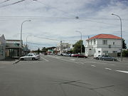
Foxton, New Zealand
Encyclopedia
Manawatu-Wanganui
Manawatu-Wanganui is a region in the lower half of the North Island of New Zealand, around the cities of Palmerston North and Whanganui. It is administered by the Horizons Regional Council.-Administration:...
region of New Zealand
New Zealand
New Zealand is an island country in the south-western Pacific Ocean comprising two main landmasses and numerous smaller islands. The country is situated some east of Australia across the Tasman Sea, and roughly south of the Pacific island nations of New Caledonia, Fiji, and Tonga...
. The 2006 census
Census
A census is the procedure of systematically acquiring and recording information about the members of a given population. It is a regularly occurring and official count of a particular population. The term is used mostly in connection with national population and housing censuses; other common...
population was 2715.
It is located on the lower west coast of the North Island
North Island
The North Island is one of the two main islands of New Zealand, separated from the much less populous South Island by Cook Strait. The island is in area, making it the world's 14th-largest island...
, in the Horowhenua district, 30 kilometres southwest of Palmerston North
Palmerston North
Palmerston North is the main city of the Manawatu-Wanganui region of the North Island of New Zealand. It is an inland city with a population of and is the country's seventh largest city and eighth largest urban area. Palmerston North is located in the eastern Manawatu Plains near the north bank...
and 15 kilometres north of Levin
Levin, New Zealand
Levin is a town in the Manawatu-Wanganui region of New Zealand, and is the largest town in the Horowhenua district. It is 90 kilometres north of Wellington, 50 kilometres south of Palmerston North, and two kilometres to the east of Lake Horowhenua....
. The town is located close to the banks of the Manawatu River
Manawatu River
The Manawatu River is a major river of the southern North Island of New Zealand.The river has its headwaters to the northwest of Norsewood in the Ruahine Ranges of southern Hawke's Bay. It flows initially eastward before turning south-west near Ormondville, flowing 40 km before turning...
. The small coastal settlement of Foxton Beach
Foxton Beach
Foxton Beach is a small settlement in the Horowhenua District of the Manawatu-Wanganui region of New Zealand's North Island. It is located on the South Taranaki Bight at the mouth of the Manawatu River, 35 kilometres southwest of Palmerston North, and six kilometres west of Foxton. Foxton Beach...
is located six kilometres to the west, close to the river mouth.
Foxton was named after Sir William Fox
William Fox (New Zealand)
Sir William Fox, KCMG was the second Premier of New Zealand on four occasions in the 19th century, while New Zealand was still a colony. He was known for his eventual support of Māori land rights, his contributions to the education system , and his work to increase New Zealand's autonomy from...
, and has a history of flax
New Zealand flax
New Zealand flax describes common New Zealand perennial plants Phormium tenax and Phormium cookianum, known by the Māori names harakeke and wharariki respectively...
stripping, which was used to make wool packs, matting, and rope. Other industries associated with the town have included clothing manufacture and sawmilling.
Climate
The area is sand country with a temperate climate, average monthly temperatures ranging from 8°C (July) to 17.4°C (January), with a minimum/maximum of -4°C to 27°C. Foxton has an average of about 2,000 sunshine hours a year, and average precipitation of about 900 mm annually. The prevailing winds in the area are west-northwest and have driven the sand back from the coast to create the most extensive transgressive sand dune system in New Zealand.History
The first inhabitants of the Manawatu area were Maori who probably arrived in the thirteenth or fourteenth century. Compared to other parts of the North IslandNorth Island
The North Island is one of the two main islands of New Zealand, separated from the much less populous South Island by Cook Strait. The island is in area, making it the world's 14th-largest island...
the district was sparsely populated, but there was a major marae at Matakarapa, across the river from Te Awahou (now Foxton) as well as kairanga (villages) and pas (fortified villages) along much of the river. A number of tribes have occupied the area; the Rangitane had replaced the Ngati Ara and the Ngati Mamoe by the 1800s and were in their turn invaded by the Ngati Toa and allies so that in the 1840s the site of Te Awahou (which was to become Foxton) was occupied by the Ngati Ngarongo and Ngati Takihiku under the leadership of Ihakara Tukumara.
Foxton is the oldest European settlement in the southern Manawatu, although it was not the first. The original white settlement was Paiaka to the east, closer to the present town of Shannon
Shannon, New Zealand
Shannon is a small town in the Horowhenua District of New Zealand's North Island. it is located 28 kilometres southwest of Palmerston North and 15 kilometres northeast of Levin. The town's population at the 2006 census was 1506....
in 1844. When Paiaka was largely destroyed by an earthquake in 1855 the settlers moved downstream to Te Awahou, which was renamed “Foxton” in the 1860s. In the early years of European settlement it was an important trading post and shipping port as the sea was the easiest way to transport goods and people to the Manawatu and the Manawatu River was then the main access to the rich hinterland. The west coast of the lower North Island is not naturally supplied with harbours and the Foxton harbour had a dangerous bar at the river mouth but as the only real harbour between Wanganui and Wellington it was used anyway.
It was only with the advent of the Palmerston North
Palmerston North
Palmerston North is the main city of the Manawatu-Wanganui region of the North Island of New Zealand. It is an inland city with a population of and is the country's seventh largest city and eighth largest urban area. Palmerston North is located in the eastern Manawatu Plains near the north bank...
-Wellington
Wellington
Wellington is the capital city and third most populous urban area of New Zealand, although it is likely to have surpassed Christchurch due to the exodus following the Canterbury Earthquake. It is at the southwestern tip of the North Island, between Cook Strait and the Rimutaka Range...
railway that Palmerston North
Palmerston North
Palmerston North is the main city of the Manawatu-Wanganui region of the North Island of New Zealand. It is an inland city with a population of and is the country's seventh largest city and eighth largest urban area. Palmerston North is located in the eastern Manawatu Plains near the north bank...
began to overtake it as the most important centre in the Manawatu. The central government originally intended for Foxton to be on the route of the main line from Wellington
Wellington
Wellington is the capital city and third most populous urban area of New Zealand, although it is likely to have surpassed Christchurch due to the exodus following the Canterbury Earthquake. It is at the southwestern tip of the North Island, between Cook Strait and the Rimutaka Range...
to Auckland
Auckland
The Auckland metropolitan area , in the North Island of New Zealand, is the largest and most populous urban area in the country with residents, percent of the country's population. Auckland also has the largest Polynesian population of any city in the world...
via Palmerston North
Palmerston North
Palmerston North is the main city of the Manawatu-Wanganui region of the North Island of New Zealand. It is an inland city with a population of and is the country's seventh largest city and eighth largest urban area. Palmerston North is located in the eastern Manawatu Plains near the north bank...
and a tramway
Light rail
Light rail or light rail transit is a form of urban rail public transportation that generally has a lower capacity and lower speed than heavy rail and metro systems, but higher capacity and higher speed than traditional street-running tram systems...
linking Foxton and Palmerston North
Palmerston North
Palmerston North is the main city of the Manawatu-Wanganui region of the North Island of New Zealand. It is an inland city with a population of and is the country's seventh largest city and eighth largest urban area. Palmerston North is located in the eastern Manawatu Plains near the north bank...
was upgraded into the Foxton Branch
Foxton Branch
The Foxton Branch was a railway line in New Zealand. It began life as a tramway, evolved into a railway by 1876, and operated until 1959. At Himatangi there was a junction with the Sanson Tramway, a line operated by the Manawatu County Council that was never upgraded to the status of a...
railway in the 1870s. However, due to government delays on extending the line further south, a group of Wellingtonian businessmen established the Wellington and Manawatu Railway (WMR) and built their line along a more direct route that bypassed Foxton. When this line opened in 1886, Foxton's status as a port slipped, and this position deteriorated further when the WMR was incorporated into the government's national rail network
Rail transport in New Zealand
Rail transport in New Zealand consists of a network of gauge railway lines in both the North and South Islands. Rail services are focused primarily on freight, particularly bulk freight, with limited passenger services on some lines...
in 1908. The railway closed in 1959, leaving only road access to the town.
Flax Booms
NZ Flax (Phormium tenax) played a major role in Foxton’s development; indeed Foxton, rather than being a "gold town" or "coal town" was indisputably a "flax town", sending their product overseas to be used worldwide as a substitute for manilaManila hemp
Manila hemp, also known as manilla, is a type of fiber obtained from the leaves of the abacá , a relative of the banana. It is mostly used for pulping for a range of uses, including speciality papers. It was once used mainly to make manila rope, but this is now of minor importance...
.
The first traders at Paiaka and Shannon
Shannon, New Zealand
Shannon is a small town in the Horowhenua District of New Zealand's North Island. it is located 28 kilometres southwest of Palmerston North and 15 kilometres northeast of Levin. The town's population at the 2006 census was 1506....
traded mostly for flax from the Maori, which was sent to Sydney
Sydney
Sydney is the most populous city in Australia and the state capital of New South Wales. Sydney is located on Australia's south-east coast of the Tasman Sea. As of June 2010, the greater metropolitan area had an approximate population of 4.6 million people...
. The first of the flax booms began in 1869, lasting for four years during which 22,000 tonnes of fibre passed through Foxton’s port . The late 1880s saw a short-lived flax boom that briefly allowed Foxton to once again grow and function as a bustling port .
A third flax boom, begun in 1898, was the most lasting and saw another increase in shipping, with over 10 steamers making regular visits. In 1903 the Moutoa Estate was developed as the main supply of flax . By 1908 problems with river silting and bar strandings meant that coastal shipping was avoiding Foxton. By 1916 there were only two ships coming into the port but in that year 97,000 bales of flax were shipped out from Foxton.
The Whirokino Cut
Though the Whirokino Cut is sometimes claimed as the reason Foxton failed to operate as a port, the dangerous bar and persistent silting were already providing problems and by the time the Cut was in place most shipping was already avoiding Foxton (by 1942 it had already ceased to function as a port).Deforestation of the inland Manawatu District in the late nineteenth century meant increased flooding and led to the creation of stopbanks, floodgates, and the Whirokino Cut. Completed in 1943 as part of the Lower Manawatu Flood Control Scheme, it was intended as a spillway but an unexpected flood broke through the upper end and diverted the river down the spillway, cutting off the Foxton loop of the river and causing great outcry at the time. The Ministry of Works said this was unintentional, but some residents felt it was done purposefully. The Foxton Loop now only has a tidal flow and isn’t connected to the river at its top end, the upper end of the Loop having silted up during a flood in 1953.
de Molen Windmill
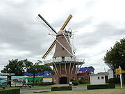
Netherlands
The Netherlands is a constituent country of the Kingdom of the Netherlands, located mainly in North-West Europe and with several islands in the Caribbean. Mainland Netherlands borders the North Sea to the north and west, Belgium to the south, and Germany to the east, and shares maritime borders...
windmill
Windmill
A windmill is a machine which converts the energy of wind into rotational energy by means of vanes called sails or blades. Originally windmills were developed for milling grain for food production. In the course of history the windmill was adapted to many other industrial uses. An important...
, called De Molen was completed and opened. This working windmill makes stone-ground flour
Flour
Flour is a powder which is made by grinding cereal grains, other seeds or roots . It is the main ingredient of bread, which is a staple food for many cultures, making the availability of adequate supplies of flour a major economic and political issue at various times throughout history...
, which can be purchased inside the mill's souvenir shop. Visitors can also view the inside mechanical workings of the mill, which are an example of traditional Dutch 17th Century craftsmanship.
Education
Foxton Primary Schools (Year 1-8):Saint Mary's,
Foxton Primary School,
Coley Street,
Foxton Beach School (Located in Foxton Beach
Foxton Beach
Foxton Beach is a small settlement in the Horowhenua District of the Manawatu-Wanganui region of New Zealand's North Island. It is located on the South Taranaki Bight at the mouth of the Manawatu River, 35 kilometres southwest of Palmerston North, and six kilometres west of Foxton. Foxton Beach...
)
Secondary:
Manawatu College
Manawatu College
Manawatu College is a high school in Foxton, New Zealand. It is a co-educational school.-House system:Each student belongs to a 'house group'...
is Foxton's only high school.