

French Pass
Encyclopedia
D'Urville Island, New Zealand
D'Urville Island is an island in the Marlborough Sounds along the northern coast of the South Island of New Zealand. It was named after the French explorer Jules Dumont d'Urville. With an area of approximately , it is the eighth-largest island of New Zealand, and has around 52 permanent...
, at the north end of the South Island
South Island
The South Island is the larger of the two major islands of New Zealand, the other being the more populous North Island. It is bordered to the north by Cook Strait, to the west by the Tasman Sea, to the south and east by the Pacific Ocean...
of New Zealand
New Zealand
New Zealand is an island country in the south-western Pacific Ocean comprising two main landmasses and numerous smaller islands. The country is situated some east of Australia across the Tasman Sea, and roughly south of the Pacific island nations of New Caledonia, Fiji, and Tonga...
, from the mainland coast. At one end is Tasman Bay
Tasman Bay
Tasman Bay is a large V-shaped bay at the north end of New Zealand's South Island. Located in the centre of the island's northern coast, it stretches along of coastline and is across at its widest point. It is an arm of the Tasman Sea, lying on the western approach to Cook Strait.At the bay's...
, and at the other end the outer Pelorus Sound
Pelorus Sound
Pelorus Sound is the largest of the sounds which make up the Marlborough Sounds at the north of the South Island, New Zealand. The Marlborough Sounds is a system of drowned river valleys, which were formed after the last ice age around 10,000 years ago...
leads out to Cook Strait
Cook Strait
Cook Strait is the strait between the North and South Islands of New Zealand. It connects the Tasman Sea on the west with the South Pacific Ocean on the east....
.
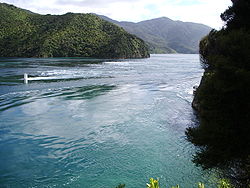
French Pass has the fastest tidal flows in New Zealand, reaching 8 knots (4 m/s). When the tide changes, the current can be strong enough to stun fish. The local tribes are Ngāti Koata and Ngāti Kuia
Ngati Kuia
Ngāti Kuia is a Māori iwi of the Northern South Island in New Zealand. They first settled in the Pelorus Sound, and later spread to the Marlborough Sounds, Nelson and Tasman districts to Taitapu on the West Coast, and as far south as the Nelson Lakes National Park...
.
History
In the oral traditionMaori mythology
Māori mythology and Māori traditions are the two major categories into which the legends of the Māori of New Zealand may usefully be divided...
of some Māori tribes, French Pass is the resting place of Kupe’s
Kupe
In the Māori mythology of some tribes, Kupe was involved in the Polynesian discovery of New Zealand.-Contention:There is contention concerning the status of Kupe. The contention turns on the authenticity of later versions of the legends, the so-called 'orthodox' versions closely associated with S....
pet king shag
King Shag
The Rough-faced Shag , also known as New Zealand King Shag or King Shag, is a rare bird endemic to New Zealand.- Description :...
, called Te Kawau-a-Toru. Kupe was a pioneer Polynesian navigator who discovered Cook Strait
Cook Strait
Cook Strait is the strait between the North and South Islands of New Zealand. It connects the Tasman Sea on the west with the South Pacific Ocean on the east....
in his canoe. While he was exploring Cook Strait, Kupe was attacked by a giant octopus. In the furious battle to kill the octopus, the coast was gouged into the convoluted shapes that today make up the Sounds. Kupe's loyal shag then led Kupe to the French Pass passage, and explored the area on Kupe’s behalf. Te Kawau-a-Toru had a huge wingspan, and was reputed to be a sacred bird with "the eye of the ancestor", insight into ancient knowledge. However, while testing the channel to see if it was safe for Kupe’s canoe, Te Kawau-a-Toru got caught in the tidal rip, broke a wing and drowned. The broken reef adjacent to the channel is Kupe’s loyal bird turned to stone – Te Aumiti a te Kawau-a-Toru (the currents that swallowed Toru’s shag). A nearby rocky point where a lighthouse now stands is the bird’s petrified bones.
The first recorded European navigation of the pass occurred in 1827. Admiral Jules Dumont d'Urville
Jules Dumont d'Urville
Jules Sébastien César Dumont d'Urville was a French explorer, naval officer and rear admiral, who explored the south and western Pacific, Australia, New Zealand and Antarctica.-Childhood:Dumont was born at Condé-sur-Noireau...
navigated the pass during his second voyage to New Zealand, in the French Navy corvette
Corvette
A corvette is a small, maneuverable, lightly armed warship, originally smaller than a frigate and larger than a coastal patrol craft or fast attack craft , although many recent designs resemble frigates in size and role...
Astrolabe
French ship Astrolabe (1817)
The Astrolabe was a horse barge converted to an exploration ship of the French Navy. She is famous for her travels with Jules Dumont d'Urville.The name derives from an early navigational instrument, the astrolabe, a precursor to the sextant.-Legacy:...
. Approaching the narrowest part of the pass, the vessel swung sideward and did not respond to steerage. The corvette struck rocks twice, and was then washed over the reef and into Admiralty Bay
Admiralty Bay, New Zealand
Admiralty Bay is a large indentation in the northern coast of New Zealand's South Island. It lies close to the northernmost mainland point of the Marlborough Sounds, immediately to the south of D'Urville Island....
. The high energy and complexity of the location was summed up by d’Urville suggesting that no one should attempt to navigate French Pass except in extreme emergency.
In 1888, a Risso’s dolphin appeared in the area. For the next 24 years, this dolphin accompanied boats to and from French Pass. He became famous as Pelorus Jack
Pelorus Jack
Pelorus Jack was a Risso's dolphin that was famous for meeting and escorting ships through a stretch of water in Cook Strait, New Zealand, between 1888 and 1912...
and was the first dolphin in the world to receive the protection of the law. Pelorus Jack stayed in the Pelorus Sounds, and did not navigate the pass into Tasman Bay. He would meet boats as they came out of the pass, riding their bow waves for 8 kilometres (5 mi) to Pelorus Sound. Then he would join boats returning to Nelson at the entrance to Pelorus Sound
Pelorus Sound
Pelorus Sound is the largest of the sounds which make up the Marlborough Sounds at the north of the South Island, New Zealand. The Marlborough Sounds is a system of drowned river valleys, which were formed after the last ice age around 10,000 years ago...
and escort them back to the pass. Pelorus Jack was last seen in April 1912. The lightkeeper at French Pass claimed he found the body of Pelorus Jack decomposing on the shore.
Tidal flows
The pass is 500 metres (1,640.4 ft) across, but the main navigation channel (the “throat” or “narrows”) contracts down to only 100 metres (328.1 ft) with a 20 metres (65.6 ft) deep shoalShoal
Shoal, shoals or shoaling may mean:* Shoal, a sandbank or reef creating shallow water, especially where it forms a hazard to shipping* Shoal draught , of a boat with shallow draught which can pass over some shoals: see Draft...
ing region. Most of the rest of the pass is broken reef.
On one side is Cook Strait with a tidal range
Tidal range
The tidal range is the vertical difference between the high tide and the succeeding low tide. Tides are the rise and fall of sea levels caused by the combined effects of the gravitational forces exerted by the Moon and the Sun and the rotation of the Earth...
up to 2 metres (6.6 ft), and on the other side is Tasman Bay with a tidal range up to 4 metres (13.1 ft). This can result in substantial pressure gradients across the pass, complicated by a phase or time difference of about 25 minutes between the high tides on either side. Peak flow in the throat of the pass is around 4 m/s.
Near to the pass are deep holes where strong vertical flows can occur. In 2000, student divers taking part in a drift dive during the local ebb flow were separated from their surface float and caught in a whirlpool. This dragged them into “Jacob’s Hole”, a 105 metres (344.5 ft) deep depression south west of the pass. The depth of this descent resulted in multiple fatalities. The group appears to have been drawn deep into the hole and then returned to the surface again. A dive computer record of one of the survivors show a depth of up to 89 metres (292 ft) According to the coroner’s report, the accident occurred on a falling tide, so the current was flowing from the south west to the north east.
External links
- Te Aumiti (French Pass) Tidal Stream - Land Information new Zealand
- McNab, Robert (1909) Murihiku: A History of the South Island of New Zealand and the Islands Adjacent and Lying to the South, from 1642 to 1835: Chapter 26: Discovery of the French Pass, 1827 Whitcomb & Tombs, Wellington.