

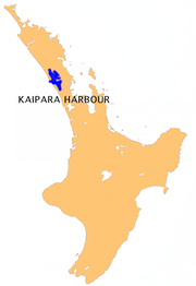
Kaipara Harbour
Encyclopedia
Estuary
An estuary is a partly enclosed coastal body of water with one or more rivers or streams flowing into it, and with a free connection to the open sea....
complex on the north western side of the North Island
North Island
The North Island is one of the two main islands of New Zealand, separated from the much less populous South Island by Cook Strait. The island is in area, making it the world's 14th-largest island...
of New Zealand
New Zealand
New Zealand is an island country in the south-western Pacific Ocean comprising two main landmasses and numerous smaller islands. The country is situated some east of Australia across the Tasman Sea, and roughly south of the Pacific island nations of New Caledonia, Fiji, and Tonga...
. The northern part of the harbour is administered by the Kaipara District
Kaipara District
-Geography:Kaipara District is located in the low hills around the northern shores of the Kaipara Harbour, a large natural harbour open to the Tasman Sea...
and the southern part is administered by the Rodney District
Rodney District
The Rodney District of New Zealand was a local government area in the northernmost part in New Zealand's Auckland Region, created in 1989 from the amalgamation of Helensville Borough and Rodney County. The seat of the district council is at Orewa, and the district includes Kawau Island to the...
. The local Māori tribe
Iwi
In New Zealand society, iwi form the largest everyday social units in Māori culture. The word iwi means "'peoples' or 'nations'. In "the work of European writers which treat iwi and hapū as parts of a hierarchical structure", it has been used to mean "tribe" , or confederation of tribes,...
is Ngāti Whātua
Ngati Whatua
Ngāti Whātua is a Māori iwi of New Zealand. It consists of four hapu : Te Uri-o-Hau, Te Roroa, Te Taoū, and Ngāti Whātua-o-Ōrākei....
.
According to Māori tradition, the name Kaipara had its origins back in the 15th century when the Arawa
Te Arawa
Te Arawa is a confederation of Māori iwi and hapu based in the Rotorua and Bay of Plenty areas of New Zealand, with a population of around 40,000.The history of the Te Arawa people is inextricably linked to the Arawa canoe...
chief, Kahumatamomoe
Kahumatamomoe
Kahumatamomoe is an early Maori explorer. He travelled with his nephew Ihenga from Rotorua to Kaipara Harbour and then alone around the Coromandel Peninsula and back to Rotorua. Lake Rotoruas full name is Te Rotoruanui-a-Kahumatamomoe and was named by Ihenga to honour his uncle....
, travelled to the Kaipara to visit his nephew at Pouto
Pouto Peninsula
The Pouto Peninsula is a landform on the northern Kaipara Harbour in Northland, New Zealand. The Peninsula runs in the north west to south east direction and is approximately 55 km long. The width varies from about 5.4 km to about 14 km, with the widest part of the peninsula near its...
. At a feast, he was so impressed with the cooked root of the para fern, that he gave the name Kai-para to the district. "Kai" means food in the Māori language
Maori language
Māori or te reo Māori , commonly te reo , is the language of the indigenous population of New Zealand, the Māori. It has the status of an official language in New Zealand...
.
Māori
Māori settlements and maraeMarae
A marae malae , malae , is a communal or sacred place which serves religious and social purposes in Polynesian societies...
have been scattered around the harbour margins for hundreds of years. The waterways of the Kaipara provided, and still provide, Māori with resources and a ready means of moving between marae.
Today most marae are associated with the Ngāti Whātua
Ngati Whatua
Ngāti Whātua is a Māori iwi of New Zealand. It consists of four hapu : Te Uri-o-Hau, Te Roroa, Te Taoū, and Ngāti Whātua-o-Ōrākei....
sub-tribes, Te Taoū and Te Uri-o-Hau. These sub-tribes both descend from the chief Haumoewhārangi who settled on the north end of the Kaipara entrance at Poutō
Pouto Peninsula
The Pouto Peninsula is a landform on the northern Kaipara Harbour in Northland, New Zealand. The Peninsula runs in the north west to south east direction and is approximately 55 km long. The width varies from about 5.4 km to about 14 km, with the widest part of the peninsula near its...
. He was killed in an argument about kūmara
Kumara
Kumara may refer to:Places* Kumara, New Zealand, a town* Kumara , a Parliamentary electoratePeople*Ajith Kumara , Sri Lankan politician*Dinesh Kumara , Sri Lankan cricketer...
(sweet potatoes). His widow Waihekeao developed a partnership with a Tainui
Tainui
Tainui is a tribal waka confederation of New Zealand Māori iwi. The Tainui confederation comprises four principal related Māori iwi of the central North Island of New Zealand: Hauraki, Ngāti Maniapoto, Ngāti Raukawa and Waikato...
warrior chief, Kāwharu. Kāwharu led several destructive campaigns around Kaipara. Eventually the descendants of Waihekeao and Haumoewhārangi came to control the Kaipara Harbour. Te Uri-o-Hau was founded by Hakiputatōmuri, and controlled the northern part of Kaipara Harbour. Te Taoū was founded by Mawake, and controlled the south.
European
In 1839, European settlersPakeha settlers
Pākehā settlers were European emigrants who journeyed to New Zealand, and more specifically to Auckland, the Wellington/Hawkes Bay region, Canterbury and Otago during the 19th century...
began arriving in the Kaipara to fell and mill kauri trees and build boats for local requirements. Despite the perilous bar at the harbour entrance, the Kaipara became a busy timber port from the 1860s, shipping thousands of tonnes of kauri timber and gum.
The Wairoa
Wairoa River, Northland
New Zealand's longest Wairoa River runs for 150 kilometres through the northern part of the North Auckland Peninsula. In the upper reaches, the river is formed from two separate rivers, the Manganui River and - confusingly - the Wairua River. The two streams meet to the northeast of Dargaville,...
is the main river feeding the Kaipara from the north. Thirty kilometres upstream, the town of Dargaville
Dargaville
Dargaville is a town in the North Island of New Zealand. It is situated on the bank of the Northern Wairoa River in the Northland region. The town is located 55 kilometres southwest of Whangarei....
was established. The stretch of water to Dargaville is broad and straight and provides an easy to navigate route into what were then kauri forests in the interior. Dargaville flourished as kauri fell and mills buzzed. Immigrants from Britain and Croatia
Croatia
Croatia , officially the Republic of Croatia , is a unitary democratic parliamentary republic in Europe at the crossroads of the Mitteleuropa, the Balkans, and the Mediterranean. Its capital and largest city is Zagreb. The country is divided into 20 counties and the city of Zagreb. Croatia covers ...
were attracted to the area. Ships up to 3,000 tons carried timber and logs out along the Wairoa to defy the bar at the harbour entrance before continuing on, usually to another New Zealand port or across the Tasman
Tasman Sea
The Tasman Sea is the large body of water between Australia and New Zealand, approximately across. It extends 2,800 km from north to south. It is a south-western segment of the South Pacific Ocean. The sea was named after the Dutch explorer Abel Janszoon Tasman, the first recorded European...
to Australia.
The Kaipara River
Kaipara River
The Kaipara River drains the area to the northwest of Auckland, New Zealand. It flows north from the northern foothills of the Waitakere Ranges, meandering past the town of Helensville...
is the principal river feeding Kaipara Harbour from the south. From 1863 Helensville established itself as a timber port on this river, and provided shipping services about the Kaipara. When the timber ran out, Helensville developed sheep and dairy farms, and more recently nut plantations, vineyards and deer farms.
Further south, Riverhead
Riverhead
Riverhead may refer to:* Riverhead, Kent, England* Riverhead, New Zealand* Riverhead, Newfoundland and Labrador, Canada* Riverhead, Nova Scotia, a community in the Canadian province of Nova Scotia* Riverhead , the debut album of Goldenhorse...
was an important trading link with the Kaipara and Helensville, and a centre for gum digging. Also set by a river, it milled timber and flour, and made paper. Later it turned to tobacco. From 1929 to 1933, the Riverhead State Forest was developed from 5,000 ha of exhausted gum land.
As the kauri ran out, the Kaipara became a backwater.Margaret McClure. Auckland places: Kaipara Harbour and kauri towns Te Ara - the Encyclopedia of New Zealand, updated 8-May-2008. After 1920 the gum and timber industries dwindled, and farming, mainly dairying, took over. In particular, there is dairying on the rich Ruāwai flats
Ruawai
Ruawai is a small township located 30 km south of Dargaville in Northland, New Zealand. The population was 426 in the 2006 Census, a decrease of 30 from 2001....
. These flats are below sea level, and are protected by a stopbank and a drainage system. Coastal sawmill settlements at Tinopai
Tinopai
Tinopai is a settlement on the Komiti Bay, part of the Hukatere Peninsula in the northern Kaipara Harbour in Northland, New Zealand. The Otamatea River flows from the north east past Tinopai and into the harbour. Matakohe is to the north....
, Arapaoa, Batley
Batley
Batley is a town within the Metropolitan Borough of Kirklees, in West Yorkshire, England. It lies southeast of Bradford, southwest of Leeds and north of Dewsbury, near the M62 motorway. It has a population of 49,448 . Other nearby towns include Morley to the northeast, Ossett to the southeast...
, Matakohe
Matakohe
Matakohe is a settlement in Northland, New Zealand. The Matakohe River is a short river which runs from the north into the Arapaoa River, which is part of the Kaipara Harbour. State Highway 12 passes through Matakohe. Ruawai is 16 km to the west, and Paparoa is 6 km north east...
, Oneriri, Ōruawharo, Pahi, Paparoa
Paparoa
Paparoa is a settlement in Northland, New Zealand. The Paparoa Stream flows from the east, through the settlement, and into the Paparoa Creek to the south, which joins the Arapaoa River which is part of the Kaipara Harbour. State Highway 12 passes through Paparoa...
, Tanoa and Whakapirau have become quiet backwaters. Pahi has become a launch point for houseboat
Houseboat
A houseboat is a boat that has been designed or modified to be used primarily as a human dwelling. Some houseboats are not motorized, because they are usually moored, kept stationary at a fixed point and often tethered to land to provide utilities...
s and fishing. Matakohe has a museum which commemorates the kauri industry and the early Pākehā
Pakeha
Pākehā is a Māori language word for New Zealanders who are "of European descent". They are mostly descended from British and to a lesser extent Irish settlers of the nineteenth and twentieth centuries, although some Pākehā have Dutch, Scandinavian, German, Yugoslav or other ancestry...
settlers.
Today, Dargaville is the principle centre in the Kaipara area. Its population levelled in the 1960s. It is the country’s main kūmara
Kumara
Kumara may refer to:Places* Kumara, New Zealand, a town* Kumara , a Parliamentary electoratePeople*Ajith Kumara , Sri Lankan politician*Dinesh Kumara , Sri Lankan cricketer...
(sweet potato) producer.
Overview
The harbour extends for some 60 kilometres (37.3 mi) from north to south. Several large arms extend into the interior of the peninsula at the northeast of the harbour, one of them ending near the town of MaungaturotoMaungaturoto
Maungaturoto is a small town in the Northland Region of New Zealand. The population was 837 in the 2006 Census, an increase of 87 from 2001. It is the second largest settlement in the Kaipara District....
, only ten kilometres (6 mi) from the Pacific Ocean
Pacific Ocean
The Pacific Ocean is the largest of the Earth's oceanic divisions. It extends from the Arctic in the north to the Southern Ocean in the south, bounded by Asia and Australia in the west, and the Americas in the east.At 165.2 million square kilometres in area, this largest division of the World...
coast. The harbour has extensive catchments feeding five rivers and over a hundred streams, and includes large estuaries formed by the Wairoa
Wairoa River, Northland
New Zealand's longest Wairoa River runs for 150 kilometres through the northern part of the North Auckland Peninsula. In the upper reaches, the river is formed from two separate rivers, the Manganui River and - confusingly - the Wairua River. The two streams meet to the northeast of Dargaville,...
, Otamatea, Oruawharo
Oruawharo River
The Oruawharo River is a river in New Zealand. It flows westward into the Kaipara Harbour west of Wellsford.-References:...
, Tauhoa (Channel) and Kaipara
Kaipara River
The Kaipara River drains the area to the northwest of Auckland, New Zealand. It flows north from the northern foothills of the Waitakere Ranges, meandering past the town of Helensville...
. A number of small islands off the shoreline are connected to the mainland by mudflats at low tide.
By area, the Kaipara Harbour is one of the largest harbours in the world. It covers 947 square kilometres (365.6 sq mi) at high tide, with 409 square kilometres (157.9 sq mi) exposed as mudflat
Mudflat
Mudflats or mud flats, also known as tidal flats, are coastal wetlands that form when mud is deposited by tides or rivers. They are found in sheltered areas such as bays, bayous, lagoons, and estuaries. Mudflats may be viewed geologically as exposed layers of bay mud, resulting from deposition of...
s and sandflats at low tide.
It is broad and mostly shallow, as it is formed from a system of drowned river valleys. The harbour shoreline is convoluted by the entry of many rivers and streams, and is about 800 kilometres (497.1 mi) long, being the drainage catchment for about 640,000 ha of land.
Harbour entrance
The harbour entrance is a channel to the Tasman SeaTasman Sea
The Tasman Sea is the large body of water between Australia and New Zealand, approximately across. It extends 2,800 km from north to south. It is a south-western segment of the South Pacific Ocean. The sea was named after the Dutch explorer Abel Janszoon Tasman, the first recorded European...
. It narrows to a width of 6 kilometres (3.7 mi), and is over 50 metres (164 ft) deep in parts. On average, Kaipara tides rise and fall 2.1 metres (6.9 ft). Spring tidal flows reach 9 km/h (5 knots) in the entrance channel and move 1,990 million cubic meters per tidal movement or 7,960 million cubic meters daily.
The harbour head is a hostile place. Big waves from the Tasman Sea break over large sandbanks
Shoal
Shoal, shoals or shoaling may mean:* Shoal, a sandbank or reef creating shallow water, especially where it forms a hazard to shipping* Shoal draught , of a boat with shallow draught which can pass over some shoals: see Draft...
about five metres below the surface, two to five kilometres from the shore. The sand in these sandbanks comes mainly from the Waikato River
Waikato River
The Waikato River is the longest river in New Zealand. In the North Island, it runs for 425 kilometres from the eastern slopes of Mount Ruapehu, joining the Tongariro River system and emptying into Lake Taupo, New Zealand's largest lake. It drains Taupo at the lake's northeastern edge, creates the...
. Sand discharged from this river is transported northward by the prevailing coastal currents. Some of this sand is carried into the Kaipara harbour entrance, but mostly cycles out again and then continues moving northwards along the west coast. The southern sandbanks at the entrance are constantly accumulating and releasing this sand.
These treacherous sandbanks shift and change position, and are known locally as the graveyard. The graveyard is responsible for more shipwrecks than any other place in New Zealand, and has claimed at least 43 vessels—some say as many as 110.
In Māori mythology
Maori mythology
Māori mythology and Māori traditions are the two major categories into which the legends of the Māori of New Zealand may usefully be divided...
, the ocean-going canoe
Maori migration canoes
Various Māori traditions recount how their ancestors set out from their homeland in great ocean-going canoes . Some of these traditions name a mythical homeland called Hawaiki....
Māhuhu
Mahuhu-ki-te-rangi
In Māori tradition, Māhuhu-ki-te-rangi was one of the great ocean-going, voyaging canoes that was used in the migrations that settled New Zealand....
voyaged from Hawaiki
Hawaiki
In Māori mythology, Hawaiki is the homeland of the Māori, the original home of the Māori, before they travelled across the sea to New Zealand...
to New Zealand and overturned on the northern side of the entrance. It was commanded by the chief Rongomai
Rongomai
In Māori mythology, Rongomai refers to several entities:* a deity by whose assistance Haungaroa traveled from Hawaiki to New Zealand as she went to tell Ngātoro-i-rangi that he had been cursed by Manaia....
, who drowned. His body was eaten by araara
White trevally
White trevally, Pseudocaranx dentex, is a jack of the family Carangidae widespread in tropical and warm temperate areas between 40°N and 47°S, in the Atlantic, Mediterranean, Indian and Pacific Oceans. It has a deep body, and a greenish colour with metallic overtones and a dark spot above the...
(white trevally), and his descendants to this day will not eat that type of fish. The first European shipwreck was the Aurora, a 550-ton barque, in 1840, and the most recent was the yacht Aosky in 1994. Today, the remains of wrecks still become visible under certain tidal and sand conditions.
For this reason, the Kaipara is rarely used today for shipping, and no large settlements lie close to its shores, although many small communities lie along its coastline.
Overview
The Kaipara Harbour is a productive marine ecosystemMarine ecosystem
Marine ecosystems are among the largest of Earth's aquatic ecosystems. They include oceans, salt marsh and intertidal ecology, estuaries and lagoons, mangroves and coral reefs, the deep sea and the sea floor. They can be contrasted with freshwater ecosystems, which have a lower salt content. Marine...
, with diverse habitat
Habitat
* Habitat , a place where a species lives and grows*Human habitat, a place where humans live, work or play** Space habitat, a space station intended as a permanent settlement...
s and ecotone
Ecotone
An ecotone is a transition area between two biomes but different patches of the landscape, such as forest and grassland. It may be narrow or wide, and it may be local or regional...
s. There are tidal reaches, intertidal mudflat
Mudflat
Mudflats or mud flats, also known as tidal flats, are coastal wetlands that form when mud is deposited by tides or rivers. They are found in sheltered areas such as bays, bayous, lagoons, and estuaries. Mudflats may be viewed geologically as exposed layers of bay mud, resulting from deposition of...
s and sandflats, freshwater swamps, maritime rushes
Juncaceae
Juncaceae, the rush family, are a monocotyledonous family of flowering plants. There are eight genera and about 400 species. Members of the Juncaceae are slow-growing, rhizomatous, herbaceous plants, and they may superficially resemble grasses. They often grow on infertile soils in a wide range...
, reed bed
Reed bed
Reed beds are natural habitats found in floodplains, waterlogged depressions andestuaries. Reed beds are part of a succession from young reed colonising open water or wet ground through a gradation of increasingly dry ground...
s and coastal scrublands. The area includes 125 square kilometres of mangrove forest
Mangrove
Mangroves are various kinds of trees up to medium height and shrubs that grow in saline coastal sediment habitats in the tropics and subtropics – mainly between latitudes N and S...
. with subtidal fringes of seagrass
Seagrass
Seagrasses are flowering plants from one of four plant families , all in the order Alismatales , which grow in marine, fully saline environments.-Ecology:...
.
The Kaipara is a migratory bird habitat of international significance. Forty–two coastal species are known, and up to 50,000 birds are common. Rare species use the harbour for feeding during summer before returning to the northern hemisphere to breed, such as the bar‑tailed godwit
Bar-tailed Godwit
The Bar-tailed Godwit is a large wader in the family Scolopacidae, which breeds on Arctic coasts and tundra mainly in the Old World, and winters on coasts in temperate and tropical regions of the Old World...
, lesser knot
Knot
A knot is a method of fastening or securing linear material such as rope by tying or interweaving. It may consist of a length of one or several segments of rope, string, webbing, twine, strap, or even chain interwoven such that the line can bind to itself or to some other object—the "load"...
, and turnstone
Turnstone
Turnstones are the bird species in the genus Arenaria in the family Scolopacidae. They are closely related to calidrid sandpipers and might be considered members of the tribe Calidriini....
. Threatened or endangered native species, such as the North Island fernbird
Fernbird
The Fernbird is an insectivorous bird endemic to New Zealand. The Māori names are Kōtātā or Mātātā. It is a rich brown above and white below, with brown spots on both the throat and breast. Early settlers called it the "Swamp Sparrow" no doubt because of its colouration. The tail feathers are...
, fairy tern
New Zealand Fairy Tern
The New Zealand Fairy Tern also known as tara-iti is a small tern which breeds on the lower half of the Northland Peninsula of the North Island of New Zealand. It is the smallest tern breeding in New Zealand and is a subspecies of the Fairy Tern.Breeding is limited to four regular sites: Waipu,...
, crake
Porzana
Porzana is a genus of birds in the crake or rail family, Rallidae. It has a global distribution, contains 13 living species, and 4-5 recently extinct ones...
, Australasian bittern
Bittern
Bitterns are a classification of birds in the heron family, Ardeidae, a family of wading birds. Species named bitterns tend to be the shorter-necked, often more secretive members of this family...
, banded rail
Rallidae
The rails, or Rallidae, are a large cosmopolitan family of small to medium-sized birds. The family exhibits considerable diversity and the family also includes the crakes, coots, and gallinules...
, grey‑faced petrels, banded and NZ dotterels, South Island pied oystercatcher
Oystercatcher
The oystercatchers are a group of waders; they form the family Haematopodidae, which has a single genus, Haematopus. They are found on coasts worldwide apart from the polar regions and some tropical regions of Africa and South East Asia...
, pied stilt, and wrybill
Wrybill
The Wrybill or Ngutuparore Anarhynchus frontalis is a species of plover endemic to New Zealand. It is unique in that it is the only species of bird in the world with a beak that is bent sideways ....
are also present . Significant local populations of black swan, pukeko, and grey duck
Duck
Duck is the common name for a large number of species in the Anatidae family of birds, which also includes swans and geese. The ducks are divided among several subfamilies in the Anatidae family; they do not represent a monophyletic group but a form taxon, since swans and geese are not considered...
also breed in the area.
Land habitats adjacent to the harbour support some rare botanical species, including native orchids, the king fern, and the endangered kaka beak
Kaka Beak
Clianthus, commonly known as Kakabeak , is a plant genus comprising two species of woody legume shrubs native to New Zealand. They have striking clusters of red flowers which resemble the beak of the Kākā, a New Zealand parrot. The plants are also known as Parrot's Beak, Parrot's Bill and Lobster...
.
Sandspit
Sandspit may refer to:* Sandspit, British Columbia, a town on Haida Gwaii, British Columbia, Canada* Sandspit Beach, a major tourist site in Karachi, Pakistan* Sandspit , a deposition landform found off coasts...
, is important as a breeding and roosting area for the New Zealand dotterel and the fairy tern
New Zealand Fairy Tern
The New Zealand Fairy Tern also known as tara-iti is a small tern which breeds on the lower half of the Northland Peninsula of the North Island of New Zealand. It is the smallest tern breeding in New Zealand and is a subspecies of the Fairy Tern.Breeding is limited to four regular sites: Waipu,...
. It also has areas of pingao
Pingao
Pingao, Ficinia spiralis, also known as golden sand sedge is a coastal sedge endemic to New Zealand . Originally widespread, it has suffered severely from competition with introduced marram grass and animal grazing and now has only a patchy distribution.Leaves from this plant are used by Maori in...
. The spit was an important habitat for the caspian tern
Caspian Tern
The Caspian Tern is a species of tern, with a subcosmopolitan but scattered distribution. Despite its extensive range, it is monotypic of its genus, and has no subspecies accepted either...
. The birds have moved to other parts of Kaipara Harbour, possibly due to human disturbance. An air weapons range used by the New Zealand Defence Force is a short distance south of the spit.
Environmental issues
As of 2011, the environmental state of the harbour has been called as "nearing crisis" and "in significant decline", with shrinking fish and shellfish stocks, more sedimentation, declining water quality and competition for resource use and development being noted as the main issues, with "ninety-nine per cent of the rivers in the catchment [are] polluted".As part of the worldwide trend, there is a decline in biodiversity
Biodiversity
Biodiversity is the degree of variation of life forms within a given ecosystem, biome, or an entire planet. Biodiversity is a measure of the health of ecosystems. Biodiversity is in part a function of climate. In terrestrial habitats, tropical regions are typically rich whereas polar regions...
within the Kaipara. The timber industry removed most of the native forest. Much of the kauri and kahikatea forest, and scrub and riparian vegetation, has been replaced with farm and urban areas. Mangrove forests and wetlands have been "reclaimed". Soil erosion has increased on the land and sedimentation in the harbour. Shellfish abundance has declined, especially toheroa, scallops, tuatua, cockles and pipi. Finfish like mullet, snapper, kanae and school shark have diminished.
Habitat fragmentation
Habitat fragmentation
Habitat fragmentation as the name implies, describes the emergence of discontinuities in an organism's preferred environment , causing population fragmentation...
has also occurred. Natural vegetation in the Kaipara catchments have been reduced to islands of wetlands and forest in man-made landscapes—separated by urban areas, roads, exotic forests and pastures. More information is needed on biodiversity in the Kaipara Harbour and habitats in associated coastal areas. A recent pilot survey found that habitats in the estuaries are still extensive, but ninety percent of land cover is no longer indigenous wetland or vegetation. Even if the key existing areas were to be protected, further buffers and corridors that give better connection between the natural areas would be needed to encourage the recovery of biodiversity.
Human use
Fisheries
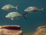
.jpg)
Fishing industry in New Zealand
As with other countries, New Zealand’s 200 nautical mile exclusive economic zone gives its fishing industry special fishing rights. It covers 4.1 million square kilometres. This is the sixth largest zone in the world, and is fourteen times the land area of New Zealand itself.The zone has a rich and...
depends on mangrove forests. About 80% of fish caught commercially are linked to food chain
Food chain
A food web depicts feeding connections in an ecological community. Ecologists can broadly lump all life forms into one of two categories called trophic levels: 1) the autotrophs, and 2) the heterotrophs...
s dependent on the mangroves, and at least 30 species of fish use mangrove wetlands at some stage of their life cycle.
The marine and estuarine areas in the Kaipara Harbour breed snapper, mullet, flounder
Rhombosolea
Rhombosolea is a genus of flounders. All four of the species in this genus can be found in the waters around New Zealand and Australia.-Species:* Yellowbelly flounder, Rhombosolea leporina ....
, sole, kahawai, white trevally
White trevally
White trevally, Pseudocaranx dentex, is a jack of the family Carangidae widespread in tropical and warm temperate areas between 40°N and 47°S, in the Atlantic, Mediterranean, Indian and Pacific Oceans. It has a deep body, and a greenish colour with metallic overtones and a dark spot above the...
, gurnard, yellow‑eyed mullet and skate
Skate
Skates are cartilaginous fish belonging to the family Rajidae in the superorder Batoidea of rays. There are more than 200 described species in 27 genera. There are two subfamilies, Rajinae and Arhynchobatinae ....
s, ray
Batoidea
Batoidea is a superorder of cartilaginous fish commonly known as rays and skates, containing more than 500 described species in thirteen families...
s and shark
Shark
Sharks are a type of fish with a full cartilaginous skeleton and a highly streamlined body. The earliest known sharks date from more than 420 million years ago....
s. The Kaipara is the largest estuarine harbour on the west coast of New Zealand and provides significant areas of suitable breeding grounds and habitat
Habitat
* Habitat , a place where a species lives and grows*Human habitat, a place where humans live, work or play** Space habitat, a space station intended as a permanent settlement...
s for juvenile fish. It has fewer problems with water quality than the Manukau
Manukau Harbour
Manukau Harbour is the second largest natural harbour in New Zealand by area. It is located to the southwest of the Auckland isthmus, and is an arm of the Tasman Sea.-Geography:...
, and is the single most significant wetland for west coast fisheries.
In 2009, NIWA
National Institute of Water and Atmospheric Research
The National Institute of Water and Atmospheric Research or NIWA , is a Crown Research Institute of New Zealand. Established in 1992, NIWA conducts commercial and non-commercial research across a broad range of disciplines in the environmental sciences...
scientists discovered that 98 percent of snapper
Australasian snapper
The Australasian snapper or Pagrus auratus is a species of porgie found in coastal waters of New Zealand and Australia. Although it is almost universally known in these countries as snapper it does not belong to the Lutjanidae family...
on the west coast of the North Island were originally juveniles from nurseries in the Kaipara. Snapper is New Zealand’s largest recreational fishery
Recreational fishing
Recreational fishing, also called sport fishing, is fishing for pleasure or competition. It can be contrasted with commercial fishing, which is fishing for profit, or subsistence fishing, which is fishing for survival....
, and is also a commercial fishery
Commercial fishing
Commercial fishing is the activity of catching fish and other seafood for commercial profit, mostly from wild fisheries. It provides a large quantity of food to many countries around the world, but those who practice it as an industry must often pursue fish far into the ocean under adverse conditions...
with an annual export value of $32 million. The findings show how fragile some fish stock
Fish stock
Fish stocks are subpopulations of a particular species of fish, for which intrinsic parameters are the only significant factors in determining population dynamics, while extrinsic factors are considered to be insignificant.-The stock concept:All species have geographic limits to their...
s can be, and highlights the importance of protecting natural habitats, like the Kaipara.
Native rock oysters are plentiful on the rocky shores, and the introduced Pacific oysters flourish lower in the intertidal zone. There are cockles
Austrovenus stutchburyi
Austrovenus stutchburyi, common name the New Zealand cockle or New Zealand little neck clam, is an edible saltwater clam, a marine bivalve mollusc in the family Veneridae, the Venus clams.-References:* Powell A. W...
and tuatua on the lower tidal flats, mussels from low tide on the rocks to subtidal beds closer to the mouth of the harbour, and scallop
Scallop
A scallop is a marine bivalve mollusk of the family Pectinidae. Scallops are a cosmopolitan family, found in all of the world's oceans. Many scallops are highly prized as a food source...
s in the tidal channels.
The scallop population has periodic incidences of high mortality, the causes of which have not been identified. Concerns in recent years about the size and availability of scallop
Scallop
A scallop is a marine bivalve mollusk of the family Pectinidae. Scallops are a cosmopolitan family, found in all of the world's oceans. Many scallops are highly prized as a food source...
s have resulted in temporary closures of the scallop fisheries.
Early versions of oyster farming
Oyster farming
Oyster farming is an aquaculture practice in which oysters are raised for human consumption. Oyster farming most likely developed in tandem with pearl farming, a similar practice in which oysters are farmed for the purpose of developing pearls...
occurred between the early 1900s and 1950s. Thousands of tons of rocks were placed along the shorelines to act as an additional substrate
Substrate (biology)
In biology a substrate is the surface a plant or animal lives upon and grows on. A substrate can include biotic or abiotic materials and animals. For example, encrusting algae that lives on a rock can be substrate for another animal that lives on top of the algae. See also substrate .-External...
on which the natural rock oyster could grow. In 2002, the Crown settled the historical claims of Te Uri o Hau, a hapu
Hapu
A hapū is sometimes described as "the basic political unit within Maori society".A named division of a Māori iwi , membership is determined by genealogical descent; a hapū is made up of a number of whānau groups. Generally hapū range in size from 150-200 although there is no upper limit...
of the northern Kaipara Harbour. As part of the settlement, access to and the rights of the hapu to gather oysters
Gathering seafood by hand
Gathering seafood by hand can be as easily as picking shellfish or kelp up off the beach, or doing some digging for clams or crabs, or perhaps diving under the water for abalone or lobsters....
within the existing "Maori Oyster Areas" were recognised. In 2008, resource consent was given to Biomarine to establish New Zealand’s largest oyster farm in the Kaipara. The farm is projected to produce about NZ$30 million in annual exports and 100 new jobs.
In recent years, there has been a perception amongst locals that commercial fishers
Commercial fishing
Commercial fishing is the activity of catching fish and other seafood for commercial profit, mostly from wild fisheries. It provides a large quantity of food to many countries around the world, but those who practice it as an industry must often pursue fish far into the ocean under adverse conditions...
have damaged fisheries in the Kaipara. Locals have been frustrated in their attempts to gain government support. The veteran film-maker Barry Barclay
Barry Barclay
Barry Barclay, MNZM was a New Zealand filmmaker and writer of Maori and Pākehā descent.-Background:...
has examined this in his 2005 documentary, The Kaipara affair.
Tidal power
In 2008, Crest Energy, a power company, received resource consentResource consent
A resource consent is the authorisation given to certain activities or uses of natural and physical resources required under the New Zealand Resource Management Act . Some activities may either be specifically authorised by the RMA or be permitted activities authorised by rules in plans...
to install about 200 underwater tidal turbines
Tidal stream generator
A tidal stream generator, often referred to as a tidal energy converter is a machine that extracts energy from moving masses of water, in particular tides, although the term is often used in reference to machines designed to extract energy from run of river or tidal estuarine sites...
in the Kaipara Harbour, which would use the substantial tidal flows moving in and out every day near the harbour mouth to produce electricity for approximately 250,000 homes.
Crest plans to place the turbines at least 30 metres deep along a ten kilometre stretch of the main channel. Historical charts show this stretch of the channel has changed little over 150 years. The output of the turbines will cycle twice daily with the predictable rise and fall of the tide. Each turbine will have a maximum output of 1.2 MW, and is expected to generate 0.75 MW averaged over time.
The peak level of generation for the combined turbines is about 200 MW. This exceeds the projected peak electricity needs of Northland. It would have environmental benefits in offsetting annual carbon emissions from a thermal-based, gas turbine generator of 575,000 tonnes of carbon. The project is costed at about $600 million and to be economic would have to be scaled up rapidly to near full capacity.
However, while the Department of Conservation has approved the project, and has made substantial environmental monitoring conditions part of the consent, the project also has objectors on the grounds of claimed influences on the local ecosystem
Ecosystem
An ecosystem is a biological environment consisting of all the organisms living in a particular area, as well as all the nonliving , physical components of the environment with which the organisms interact, such as air, soil, water and sunlight....
s and charter fishing (see the section below on Fisheries). Appeals before the Environment Court are still likely.
Sand mining
Currently (2007) about 219,000 cubic metres of sand is minedSand mining
Sand mining is a practice that is becoming an environmental issue as the demand for sand increases in industry and construction. Sand is mined from beaches and inland dunes and dredged from ocean beds and river beds. It is often used in manufacturing as an abrasive, for example, and it is used to...
each year from the entrance and tidal delta
River delta
A delta is a landform that is formed at the mouth of a river where that river flows into an ocean, sea, estuary, lake, reservoir, flat arid area, or another river. Deltas are formed from the deposition of the sediment carried by the river as the flow leaves the mouth of the river...
s of the Kaipara. This sand contributes over half the sand requirements for Auckland
Auckland
The Auckland metropolitan area , in the North Island of New Zealand, is the largest and most populous urban area in the country with residents, percent of the country's population. Auckland also has the largest Polynesian population of any city in the world...
. The sand is used in the production of concrete and asphalt, and also in drainage
Drainage
Drainage is the natural or artificial removal of surface and sub-surface water from an area. Many agricultural soils need drainage to improve production or to manage water supplies.-Early history:...
systems and beach nourishment
Beach nourishment
Beach nourishment— also referred to as beach replenishment—describes a process by which sediment lost through longshore drift or erosion is replaced from sources outside of the eroding beach...
. A suction pump is usually used to extract the sand from the seabed. It is pumped into a barge as a sand and water slurry. As the barge loads, shells and other objects are screened out and the sea water drained back to the sea. The availability of sea sand within the Auckland region means the road costs of transporting sand from further parts of the country are avoided. Concerns about possible negative consequences of this sand mining have also been raised.
Management issues
Management of the Kaipara Harbour does not have a central administration. Management is distributed among the Kaipara DistrictKaipara District
-Geography:Kaipara District is located in the low hills around the northern shores of the Kaipara Harbour, a large natural harbour open to the Tasman Sea...
Council, Auckland Council
Auckland Council
The Auckland Council is the council for the Auckland Region in New Zealand. It began operating on 1 November 2010, combining the functions of the existing regional council and the region's seven previous city and district councils into one "super council" or "super city" governed by a mayor, 20...
, Northland Regional Council, the Department of Conservation's Northland and Auckland section, and the Ministry of Fisheries.
The Ministry of Fishing
Ministry of Fisheries (New Zealand)
The Ministry of Fisheries , also known by its acronym MFish, is a state sector organisation of New Zealand whose role is ensuring the sustainable utilisation of fisheries. This involves conserving, using, enhancing and developing New Zealand's fisheries resources. New Zealand's Minister of...
allocates quota for the north west region of New Zealand as a whole, but does not tailor quota specifically for the Kaipara. Local iwi
Iwi
In New Zealand society, iwi form the largest everyday social units in Māori culture. The word iwi means "'peoples' or 'nations'. In "the work of European writers which treat iwi and hapū as parts of a hierarchical structure", it has been used to mean "tribe" , or confederation of tribes,...
feel they are not sufficiently involved in management issues, and to further compound matters, the local iwi
Iwi
In New Zealand society, iwi form the largest everyday social units in Māori culture. The word iwi means "'peoples' or 'nations'. In "the work of European writers which treat iwi and hapū as parts of a hierarchical structure", it has been used to mean "tribe" , or confederation of tribes,...
is split between Te Uri-o-Hau in the northern part and Te Taoū in the southern part.
Ecological management and environmental issues are discussed in the Ecology section.
Timeline
- c. 1300: The Maori chief RongomaiRongomaiIn Māori mythology, Rongomai refers to several entities:* a deity by whose assistance Haungaroa traveled from Hawaiki to New Zealand as she went to tell Ngātoro-i-rangi that he had been cursed by Manaia....
arrives in his canoeMaori migration canoesVarious Māori traditions recount how their ancestors set out from their homeland in great ocean-going canoes . Some of these traditions name a mythical homeland called Hawaiki....
MāhuhuMahuhu-ki-te-rangiIn Māori tradition, Māhuhu-ki-te-rangi was one of the great ocean-going, voyaging canoes that was used in the migrations that settled New Zealand....
from HawaikiHawaikiIn Māori mythology, Hawaiki is the homeland of the Māori, the original home of the Māori, before they travelled across the sea to New Zealand...
, and is drowned at the harbour entrance. - 1807 or 1808: Ngapuhi fight Ngāti Whātua, Te-Uri-o-Hau and Te Roroa iwi at the battle of MoremonuiMoremonuiMoremonui or Moremunui is a location in the Northland Region of New Zealand, 12 miles south of Maunganui Bluff. It is known principally as the site of a Māori battle fought in either 1807 or 1808 between the Kaipara branches of the Ngāti Whātua, Te-Uri-o-Hau and Te Roroa iwi on one side and the...
on the west coast of Northland, the first battle in which Maori used muskets. - 1839: European settlers begin arriving to fell and mill kauri trees.
- 1840: The Aurora, a 550-ton barqueBarqueA barque, barc, or bark is a type of sailing vessel with three or more masts.- History of the term :The word barque appears to have come from the Greek word baris, a term for an Egyptian boat. This entered Latin as barca, which gave rise to the Italian barca, Spanish barco, and the French barge and...
, is the first European ship to be wrecked at the entrance. - 1860s: The timber industry is established.
- 1899: The timber industry peaks.
- c. 1939: Timber trade ends, and the area becomes a backwater.
- 2002: Crown settles historical claims of Te Uri o Hau
- 2005: Film-maker Barry BarclayBarry BarclayBarry Barclay, MNZM was a New Zealand filmmaker and writer of Maori and Pākehā descent.-Background:...
makes his documentary, The Kaipara Affair. - 2008: Biomarine receives resource consent to establish an oyster farm
- 2008: Crest Energy receives resource consent to install tidal turbines
Reading
- Scott, Dick (1988) Seven Lives on Salt River. Hodder & Stoughton/Southern Cross. ISBN 978-0-340-49296-3 (explores seven early families who lived on the shores of the Pahi and Arapāoa rivers).
External links
- Integrated Kaipara Harbour Management Group
- Te Tiaki Mahinga Kai – coalition of Māori environmental guardians supporting the management of customary fishing areas.
- Kaipara lighthouse 1884, NZ