

Oxford, New Zealand
Encyclopedia
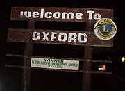
Oxford is a small town of 1,716 people serving the farming community of North Canterbury, New Zealand
. It is part of the Waimakariri District
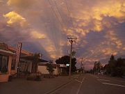
. Oxford is a linear town, approximately two kilometres long. For a time Oxford was serviced by the Oxford Branch railway, and had two stations, East Oxford and West Oxford. Due to declining traffic, the line was closed in 1959 and subsequently removed. Some railway signs and the remnants of some old railway platforms can still be seen along Oxford Road on the way to Rangiora.
Oxford was originally a logging town: trees were felled from forests in the area, and then hauled by beast to Christchurch. A mural depicting life from that era is painted on the side wall of the butchers shop.
Oxford has won awards for both the most beautiful village, and the most beautiful toilet .
 Oxford is located at the inland edge of the Canterbury Plains
, approximately 50 km northwest of Christchurch
, at 43°18' South 172°11' East (-43.1666, 172.0833)
http://earth-info.nga.mil/gns/html/cntry_files.html. The township is about 30 km from Rangiora
to the East, and the townships of Sheffield and Darfield to the west.
Oxford can be reached from Christchurch by means of Tram Road, which has the longest straight section of road in New Zealand.
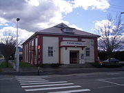
 Oxford's excellent historical museum is housed in a building that was built by the community from more than 20,000 hand-made bricks.
Oxford has both a restaurant, Cafe 51, and a cooking school, Seagars, operated by celebrity TV chef Jo Seagar.
There is work under way to create a bee heritage centre.
A Farmers' Market operates in Main St, between the Service Centre and the butcher, every Sunday from 9:30 to 12:30. This is the only Canterbury Farmers' market to operate year round. A Craft Market runs on the first Sunday of each month in the Town Hall.
Oxford has a Town Hall, which opened in 1931. The new town hall was intended to replace two previous town halls and was seen as one means to unify East Oxford and West Oxford into a single township.
 The community saved hard during 2005 and 2006 to raise funds for such projects as a community-based swimming pool in Burnett Street (the Oxford Community Pool) and a first-response ambulance to assist local citizens. The town prides itself on its ability to self-fund community projects through organizations such as the Lions.
Oxford has several Churches and Organisations
to provide charitable support to war widows. To raise money, the League showed films in the old Oxford Town Hall. The OB&I still exists and provides charitable support to the citizens of Oxford. Today, movies are screened in the Town Hall on approximately every other Saturday during the winter. The heyday of the OB&I movies was the middle of the 20th century, when three or four films would be shown every week, and queues often extended around the building. This was before private car ownership became popular as the nearest cinema was in Christchurch, some 50 km distant.
Canterbury, New Zealand
The New Zealand region of Canterbury is mainly composed of the Canterbury Plains and the surrounding mountains. Its main city, Christchurch, hosts the main office of the Christchurch City Council, the Canterbury Regional Council - called Environment Canterbury - and the University of Canterbury.-...
. It is part of the Waimakariri District
Waimakariri District
The Waimakariri District is a political district of New Zealand, located in the South Island, on the eastern coast of north Canterbury. It is north of Christchurch and the Waimakariri River and is a part of the greater Canterbury region. The name is Māori for cold river.The district was established...
. Oxford is a linear town, approximately two kilometres long. For a time Oxford was serviced by the Oxford Branch railway, and had two stations, East Oxford and West Oxford. Due to declining traffic, the line was closed in 1959 and subsequently removed. Some railway signs and the remnants of some old railway platforms can still be seen along Oxford Road on the way to Rangiora.
Oxford was originally a logging town: trees were felled from forests in the area, and then hauled by beast to Christchurch. A mural depicting life from that era is painted on the side wall of the butchers shop.
Oxford has won awards for both the most beautiful village, and the most beautiful toilet .
Geography
Canterbury Plains
The Canterbury Plains are an area in New Zealand centred to the south of the city of Christchurch in the Canterbury Region. Their northern extremes are at the foot of the Hundalee Hills in the Hurunui District, and in the south they merge into the plains of North Otago beyond the Waitaki...
, approximately 50 km northwest of Christchurch
Christchurch
Christchurch is the largest city in the South Island of New Zealand, and the country's second-largest urban area after Auckland. It lies one third of the way down the South Island's east coast, just north of Banks Peninsula which itself, since 2006, lies within the formal limits of...
, at 43°18' South 172°11' East (-43.1666, 172.0833)
http://earth-info.nga.mil/gns/html/cntry_files.html. The township is about 30 km from Rangiora
Rangiora, New Zealand
Rangiora is a rural town in the South Island of New Zealand. It is the largest town in north Canterbury and the seat of the Waimakariri District Council.-Geography:...
to the East, and the townships of Sheffield and Darfield to the west.
Oxford can be reached from Christchurch by means of Tram Road, which has the longest straight section of road in New Zealand.
Amenities
Oxford has both a restaurant, Cafe 51, and a cooking school, Seagars, operated by celebrity TV chef Jo Seagar.
There is work under way to create a bee heritage centre.
A Farmers' Market operates in Main St, between the Service Centre and the butcher, every Sunday from 9:30 to 12:30. This is the only Canterbury Farmers' market to operate year round. A Craft Market runs on the first Sunday of each month in the Town Hall.
Oxford has a Town Hall, which opened in 1931. The new town hall was intended to replace two previous town halls and was seen as one means to unify East Oxford and West Oxford into a single township.
Community
Oxford has several Churches and Organisations
Oxford Union Church (Presbyterian)
Oxford Baptist Church
Catholic Church
Seventh Day Adventist Church
Anglican Church
Tawera Masonic Lodge
Oxford Working Men’s Club
West Oxford Hotel (Public House - The West)
Oxford Benevolent and Improvement League
The OB&I is an organization formed during World War IWorld War I
World War I , which was predominantly called the World War or the Great War from its occurrence until 1939, and the First World War or World War I thereafter, was a major war centred in Europe that began on 28 July 1914 and lasted until 11 November 1918...
to provide charitable support to war widows. To raise money, the League showed films in the old Oxford Town Hall. The OB&I still exists and provides charitable support to the citizens of Oxford. Today, movies are screened in the Town Hall on approximately every other Saturday during the winter. The heyday of the OB&I movies was the middle of the 20th century, when three or four films would be shown every week, and queues often extended around the building. This was before private car ownership became popular as the nearest cinema was in Christchurch, some 50 km distant.