

Poverty Bay
Encyclopedia
New Zealand
New Zealand is an island country in the south-western Pacific Ocean comprising two main landmasses and numerous smaller islands. The country is situated some east of Australia across the Tasman Sea, and roughly south of the Pacific island nations of New Caledonia, Fiji, and Tonga...
's North Island
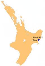
North Island
The North Island is one of the two main islands of New Zealand, separated from the much less populous South Island by Cook Strait. The island is in area, making it the world's 14th-largest island...
to the north of Hawkes Bay. It stretches for 10 kilometres from Young Nick's Head
Young Nick's Head
Young Nick's Head is a headland at the southern end of Poverty Bay in New Zealand's North Island. It is clearly visible from the nearby city of Gisborne....
in the southwest to Tuaheni Point
Tuaheni Point
Tuaheni Point is a promontory on the east coast of the North Island of New Zealand. It marks the northernmost point of Poverty Bay, and is located close to the city of Gisborne. The small settlement of Wainui Beach lies just to the north of Tuaheni Point....
in the northeast. The city of Gisborne
Gisborne, New Zealand
-Economy:The harbour was host to many ships in the past and had developed as a river port to provide a more secure location for shipping compared with the open roadstead of Poverty Bay which can be exposed to southerly swells. A meat works was sited beside the harbour and meat and wool was shipped...
is located on the northern shore of the bay. The name is often used by extension to refer to the entire area surrounding the city of Gisborne.
The first European known to have set foot in New Zealand
New Zealand
New Zealand is an island country in the south-western Pacific Ocean comprising two main landmasses and numerous smaller islands. The country is situated some east of Australia across the Tasman Sea, and roughly south of the Pacific island nations of New Caledonia, Fiji, and Tonga...
, Captain James Cook
James Cook
Captain James Cook, FRS, RN was a British explorer, navigator and cartographer who ultimately rose to the rank of captain in the Royal Navy...
, did so here on 7 October 1769. This first meeting led to the deaths of 6 local Maori during skirmishes with the crew. Cook was unable to gain many of the provisions he and his crew needed at the bay, and for this reason gave it its name.
Poverty Bay is one of the more fertile areas of New Zealand and famous for its Chardonnay
Chardonnay
Chardonnay is a green-skinned grape variety used to make white wine. It is originated from the Burgundy wine region of eastern France but is now grown wherever wine is produced, from England to New Zealand...
, fruit, vegetables and avocados, with abundant sunshine and fertile alluvial soil.
Catchment and sediment supply
The bay is fed by the Waipaoa RiverWaipaoa River
The Waipaoa River is a river of the northeast of New Zealand's North Island. It rises on the eastern slopes of the Raukumara Range, flowing south for 80 kilometres to reach Poverty Bay and the Pacific Ocean just south of Gisborne. For about half of this distance its valley is followed by State...
, whose catchment is 2205 km² - large enough for individual storms and events to have a small impact on the sedimentary outflow. The river's alluvial buffering is also minimal, and 95% of sediments are trapped by subduction-related anticlines on the bay's seaward flank. This has led to Poverty Bay becoming a case area for sedimentary studies. The sediments of the bay provide records of changes brought about by the onset of the ENSO
Enso
Ensō is a Japanese word meaning "circle" and a concept strongly associated with Zen. Ensō is one of the most common subjects of Japanese calligraphy even though it is a symbol and not a character. It symbolizes the Absolute enlightenment, strength, elegance, the Universe, and the void; it can...
, colonisation of NZ by Polynesians (and associated deforestation), subsequent deforestation by westerners, and the Taupo eruption.
Poverty Bay Massacre
In 1868 Te KootiTe Kooti
Te Kooti Arikirangi Te Turuki was a Māori leader, the founder of the Ringatu religion and guerrilla.While fighting alongside government forces against the Hauhau in 1865, he was accused of spying. Exiled to the Chatham Islands without trial along with captured Hauhau, he experienced visions and...
, a Maori 'rebel' leader, landed at Whareongaonga Bay, near Young Nick's Head in Poverty Bay, with 300 odd mostly Hauhau warriors with women and children, in the schooner "Rifleman". Having overcome the crew without bloodshed and made an escape from the Chatham Islands where he and these Hauhau Maori had been incarcerated without trial. From there he ventured inland to wage guerilla war on the armed constabulary and sympathetic Maori for several years, as well as several raids on settlers and antipathetic Maori villages. On 10 November 1868 Te Kooti and his followers attacked the township of Matawhero on the outskirts of Gisborne. Some 54 people were slaughtered, including women and children. The dead included 22 local Māori as well as European settlers.