

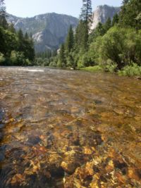
Merced River
Encyclopedia
The Merced River in the central part of the U.S. state
of California
, is a 145 miles (233.4 km)-long tributary
of the San Joaquin River
flowing from the Sierra Nevada into the Central Valley. It is most well known for its swift and steep course through the southern part of Yosemite National Park
, and the world-famous Yosemite Valley
. The river's character changes dramatically once it reaches the foothills
and the lowlands, becoming a slow-moving waterway meandering through irrigated fields.
When tectonic activity first led to the uplift of the Sierra, the river formed as a steep stream eroding into the range's western flank, carrying sediments that would later help form the floor of the Central Valley. A rich riparian zone
around the Merced once supported millions of migratory birds along the Pacific Flyway
, and the river had one of the southernmost runs of salmon
in North America. Indigenous people, including the Miwok
and Paiute
tribes, lived along the river for thousands of years, thriving on the bountiful flora and fauna supported by the river and its diverse lower course, aided by fertile soils eroded from the mountains.
Military expeditions sent by the government of Mexico
which then held sovereignty over Alta California
passed through the Merced River region in the early 19th century. Later settler
s were predominantly American, who discovered gold
in the Sierra Nevada, leading to the establishment of a railroad
along the river, bringing minerals and lumber to towns that had been established on the lower Merced, and helping increase tourism to the future national park area. Conflicts between whites and indigenous prompted wars, resulting in the expulsion of the Ahwahnechee
tribe from Yosemite Valley. In the 20th century, the river saw further development that would change its state forever.
Large-scale irrigated agriculture was introduced to the Central Valley in the late 19th century, and led to the construction of numerous state, federal and privately owned dams. Water demand has often been higher than the river's environment can sustain. Salmon
have been blocked from migrating and riverside habitat has declined dramatically. Recent years have seen habitat conservation
work, mimicking of historic streamflow patterns, and the establishment of a salmon hatchery, in the hopes that the river's health can be protected from further damage.
, a subrange of the Sierra Nevada. The river flows through a steep-walled granite canyon for nearly 10 miles (16.1 km) before spilling into Little Yosemite Valley
, a glacial valley that precedes the more famous Yosemite Valley
. After meeting up with the John Muir Trail
, the Merced River drops over Nevada Falls and Vernal Falls
, receives Illilouette Creek, and passes into the main Yosemite Valley, where it meanders between pine forests that fill the valley floor.
Tenaya
, Yosemite
, Bridalveil and Pigeon Creeks join the Merced before it breaches the glacial moraine
at the valley's end. From there the river picks up Cascade Creek and turns south near El Portal
, flowing through Merced River Canyon. State Route 140
follows the river out of the west entrance to the national park, a few miles before the South Fork Merced River
, the largest tributary, joins from the left. The river arcs northwest to receive the North Fork, and a few miles after it enters Lake McClure
, formed by New Exchequer Dam
. The remainder of the river continues to flow west across the Central Valley before joining the San Joaquin River a few miles south of Turlock
.
of the Merced River is located in the central Sierra Nevada, spreading across 1726 square miles (4,470.3 km²). It can be characterized as the slightly smaller southern companion of the Tuolumne River
, the major Sierran river just north of the Merced. On the south, the basin borders on the headwaters of the San Joaquin River itself. The Merced River watershed includes the subwatersheds of Illilouette, Echo, Tenaya, Yosemite, Bridalveil, Cascade, and Dry Creeks, as well as the South and North forks of the river, of which the South Fork, at 43 miles (69.2 km) long, is the largest. Tributaries to the South Fork include Bishop, Rail, Alder and Chilnualna Creeks. There are also many lakes in the watershed of the Merced River, including Merced Lake, Tenaya Lake
, the Chain Lakes, May Lake, Lake McClure
, and Lake McSwain.
Much of the basin of the Merced River is characterized by an alpine climate
. The upper basin of the river receives heavy snowfall in the winter, which is usually enough to feed the river and its tributaries year round. However, most of the snowpack melts by the late autumn, reducing flows in the main stem and its tributaries significantly, and causing some smaller tributaries to dry up altogether. Snowmelt constitutes a majority of the river's springtime and early summer flow, and provides up to 85% of the flow above Happy Isles
. The dry season depends more on groundwater
to supply the river's flow. The middle and lower basin are dominated by an arid, Mediterranean
or even semi-desert climate.
The Merced River is the third largest tributary of the San Joaquin River. Before irrigation started in the Central Valley and dams were constructed, the river's natural flow at the mouth was much higher than the current average of 661 cuft/s, or about 479000 acre.ft per year. Upper on the river, at Happy Isles, the average flow is 355 cuft/s. The United States Geological Survey
has river gauge
s at three locations along the Merced River: at Happy Isles
, Lake McClure
, and at the mouth. The first two record flows unaffected by dams and human intervention, but discharge at the mouth is chiefly controlled by New Exchequer Dam. The Lake McClure gauge is probably the most accurate gauge for flows overall. The average annual flow recorded there was 725 cuft/s from 1901 to 1964. A peak of 47700 cuft/s was reported there in 1911. For the mouth gauge, the highest flow was only 13600 cuft/s in 1950. Finally, for the gauge at Happy Isles, the largest flow ever recorded was 10100 cuft/s in the 1997 Yosemite floods, which destroyed many campgrounds, roads, paths, and bridges in the valley.
The Merced River's primary human use is irrigation
. The Merced Irrigation District (MID) operates most of the irrigation infrastructure, which supplies water to 154394 acres (624.8 km²) of farmland. As a whole, the system includes about 4,000 sets of control gates and 793 miles (1.3 km²) of canals. Irrigation has taken most of the water out of the lower river, which now rarely reaches the sea. Water that does return to the river does so in for form of irrigation return flows, which carry pesticide
s, fertilizer
and other pollutants. The MID is federally required to allow at least 15000 acre.ft of water annually to flow continually down the river, not including flooding. The water has allowed the San Joaquin River below the Merced River confluence to contain water, while above the confluence all of its water is usually diverted for irrigation.
, 127 bird
species, and 140 insect
and invertebrate
species found in the Merced River watershed. Most of these species are divided between the upper and lower watershed, which is usually defined by Lake McClure
, formed by New Exchequer Dam
.
Of the fish, there were 26 species found in the lower Central Valley portion of the river, including Sacramento sucker
, smallmouth bass
, largemouth bass
and carp
, all but three of which are resident species, and some of which were intentionally introduced by humans. The three anadromous fish species that still use the lower Merced are the chinook salmon
, Pacific lamprey
and striped bass
. The upper section of the river, defined as the stretch from Lake McClure
to the headwaters, had 11 species of fish. Historically, the range of anadromous fish extended to the head of Yosemite Valley, but by the 1950s and 1960s, except in the wettest years, not enough water flowed down the Merced and San Joaquin Rivers at all to allow them to spawn in significant numbers. New water use requirements have allowed many anadromous species to revitalize, from a low of 500 chinook salmon in the mid-20th century to a high of 30,000 fish in 1984. After the 1970s, the annual run was about 5,300 fish.
Of the one hundred and twenty-seven bird species found along the Merced River, only 35 occur along the entire length of the river. Many of these birds are migratory and only pass the area a few times every year, while 109 species of birds are found only in the breeding season
. However, despite the more extensive modifications to the lower part of the river, there are more species of birds found in the lower watershed, due to the slow-flowing nature of the river that forms marsh
es and riparian zone
s. Common species of bird throughout the basin include ruby-crowned kinglet, cedar waxwing
, American robin
, yellow-rumped warbler
, tree swallow
and European starling
, and several endangered species, including white-tailed kite
and Swainson's hawk
. Birds that occur commonly in the middle and upper sections of the Merced River include mourning dove
, Cassin's finch
, California quail
, dark-eyed junco
, woodpecker
, dipper
, great blue heron
, scrub jay, red-winged blackbird
, red-tailed hawk
, turkey vulture
, cliff swallow
, canyon wren
, merganser, and rarely, bald eagle
. Of the 140 insect and invertebrate species, which include mayflies
, stoneflies and caddisflies, there are also three major exotic species: Asiatic clam, Chinese mitten crab
, and New Zealand mud snail
.
Many species of plants are found throughout the middle and upper basin, including California poppy
, white alder, Oregon ash
, oak
, poison oak
, bigleaf maple
, Indian rhubarb, buttonbush
, willow
, whiteleaf manzanita
, and historically, sugar pine
, before logging began in the late 19th century. Squirrel
s, raccoon
, jackrabbits, bat
s, skunk
s, beaver
s, mule deer
, coyote
, bobcat
and black bear
are among the mammal species found in the middle and upper watershed.
One species of interest is the limestone salamander
, an extremely rare amphibian whose only habitat is in the Merced Canyon downstream of Yosemite Valley. The limestone salamander depends on the granite walls of the Merced Canyon to survive. To protect the species, a 20 miles (32.2 km) segment of the canyon covering 1600 acres (6.5 km²) was designated in 1986 an "Area of Critical Environmental Concern".
on its slow journey westwards encountered the Pacific Plate
approximately 250 million years ago during the Paleozoic
, the latter began to subduct under the North American continent. Intense pressure underground caused some of the Pacific Plate to melt, and the resulting upwelling magma
pushed up and hardened into the granite
batholith
that makes up much of the Sierra Nevada. Extensive layers of marine sedimentary rock
that originally made up the ancient Pacific seabed were also pushed up by the rising granite, and the ancestral Merced River formed on this layer of rock. Over millions of years, the Merced cut a deep canyon through the softer sedimentary rock, eventually hitting the hard granite beneath. The encounter with this resilient rock layer caused the Merced River to mostly stop its downcutting, although tributary streams continued to widen the ancient canyon.
Over about 80 million years, erosion caused the transportation of massive amounts of alluvial sediment
to the floor of the Central Valley, where it was trapped between the California Coast Range on the west and the Sierra Nevada on the east, forming an incredibly flat and fertile land surface. The present-day form of the upper Merced River watershed, however, was formed by glacier
s, and the lower watershed was indirectly but significantly affected.
When the last glacial period or Ice Age
arrived, a series of four tremendous valley glaciers filled the upper basin of the Merced River. These glaciers rose in branches upstream of Yosemite Valley, descending from the Merced River headwaters, Tenaya Canyon and Illilouette Creek. Tenaya Canyon was actually eroded even deeper by an arm of the Tuolumne Glacier, which formed the Grand Canyon of the Tuolumne
and Hetch Hetchy Valley
on the Tuolumne River
in the north. Little Yosemite Valley
formed as a result of the underlying rock being harder than that below the Giant Staircase, the cliff wall containing Vernal Fall and Nevada Fall
. These three branches of each glacier combined to form one large glacier about 7000 feet (2,133.6 m) thick at maximum, stretching 25 miles (40.2 km) downstream past the mouth of Yosemite Valley, well into Merced Canyon. These glaciers formed the granite cliffs that now constitute landmarks such as Half Dome
, El Capitán
, and Cloud's Rest.
The first and largest glacier was the Sherwin or Pre-Tahoe glacier, which eroded the upper Merced watershed to an extent close to its present form. Three stages followed during the Wisconsinian glaciation; these were the Tahoe, Tenaya and Tioga stages, of which the Tioga was the smallest. The Tioga glacier left at the mouth of Yosemite Valley a rocky moraine
. This moraine was actually one of several moraines deposited by the four glaciations, which include Medial Moraine and Bridalveil Moraine. After the Tioga Glacier retreated this moraine formed a lake that flooded nearly the entire valley. Gradual sedimentation
filled Lake Yosemite, creating a broad and flat valley floor. Sediments of glacial origin continued to travel down the Merced River following then, helping to form the flat floor of the Central Valley.
(consisting of Plains Miwok and Sierra Miwok), Paiute
, and Ahwahnechee
. Many Plains Miwok settled in the lowlands along the lower Merced River. The Sierra (or Mountain) Miwok lived in the upper Merced Canyon and in Yosemite Valley, and at the time the first white explorers came to the area, there were about 450 Sierra Miwok split among ten permanent villages. Paiute, of origin from the eastern Sierra near the Mono Lake
area, also lived in the upper watershed of the Merced River. The Sierra Miwok and Mono Lake Paiute eventually, through cultural interaction over time, formed a new culture, the Ahwahnechee
, derived from Ahwahnee, meaning "the valley shaped like a big mouth" (referring to U-shaped Yosemite Valley).
In the early 19th century, several military expeditions sent by Spanish
colonists of southern California and Baja California
traveled into the Central Valley. One of these trips, headed by lieutenant Gabriel Moraga
, arrived on the south bank of the Merced River on January 6, 1806. They named the river Rio de Nuestra Señora de Merced (River of our Lady of Mercy). The expedition also named many other major rivers in the Central Valley, including the Kings River
. Moraga's expedition was part of a series of exploratory ventures, funded by the Spanish government, to find suitable sites for missions in the Central Valley and the Sierra Nevada foothills. In 1808 and 1810, Moraga led further expeditions along the lower Merced River below Merced Canyon, each time coming to nothing. Eventually, plans to establish a mission chain in the Valley were abandoned. In 1855, Merced County
was created, named after the Merced River.
Following the establishment of Merced County and the independence of California from Mexico, many settlers came to the Merced River area and established small towns on the Merced River. One of the first was Dover, established in 1844 at the confluence of the Merced River with the San Joaquin River. Dover functioned as an "inland seaport" where boats delivered supplies from the San Francisco Bay
area to settlers in the San Joaquin Valley. Some towns that followed were Hopeton
, Snelling
and Merced Falls
, the latter named for a set of rapids on the Merced River near the present-day site of McSwain Dam. In the late 1880s a flour mill, woolen mill and a few lumber mills were constructed at Merced Falls. The Sugar Pine Lumber Company and Yosemite Lumber Company operated lumber mills at Merced Falls for over thirty years, relying on narrow-gauge railroads to ship lumber from the Sierra Nevada along the Merced River. Following the construction of the Central Pacific
and Southern Pacific Railroad
s, many of the river towns on the Merced River were deserted. Several cities that did achieve prominence, however, include Merced
and Turlock
, both located on the railroad.
 The California Gold Rush
in the 1850s saw gradually increasing mining in Merced Canyon and Yosemite Valley. Many Native Americans in the area revolted, leading to conflicts between miners and the Ahwahnechee. In 1851 the Mariposa Battalion
was formed to drive the remaining Ahwahnechee out of the valley into reservations. The Battalion fought a Ahwahnechee group led by Chief Tenaya
over the South Fork of the Merced River. Eventually, they succeeded in driving most of the Indians out of the Yosemite Valley, first into a reservation near Fresno
. Following the gold rush, the Ahwahnechee were allowed back into Yosemite Valley, but further incidents prompted a second battalion to drive them out, this time to the Mono Lake
area. Many place names in the valley have their origin from the Mariposa Battalion.
Even before the establishment of Yosemite National Park
, tourists began to travel into the Merced Canyon and Yosemite Valley as early as 1855. The first roads were constructed into Yosemite Valley in the 1870s. The first was Coulterville Road, followed by Big Oak Flat Road, a trading route from Stockton
to Merced Canyon. Environmental movements led by John Muir
and Robert Underwood Johnson
convinced the U.S. Congress to establish Yosemite National Park in 1890. With the creation of the national park tourism to the Valley and the Merced River increased significantly, leading to many other roads being built throughout the upper Merced River watershed. Other national forests protecting more of the Merced River upper basin followed, including Sierra National Forest
and Stanislaus National Forest
.
The Yosemite Valley Railroad
, originally established with the discovery of mineral deposits in Yosemite Valley and Merced Canyon, continued functioning through the early 20th century carrying tourists to Yosemite Valley along the Merced River. El Portal Road
, constructed through Merced Canyon in 1926, put an end to passenger service on the railway, but operations continued until the mid-1940s, when major flooding occurred, destroying sections of the railroad.
In the early 20th century, when the upper Merced River basin lay mostly protected, the lower river was the subject of dam-building and irrigation diversions by the Merced Irrigation District
. The District proposed the Exchequer Dam
, completed in the mid-1920s and raised in the 1960s, as a water storage facility on the Merced River.
Irrigation with water from the Merced River continued to grow substantially until most of the arable land
around the river, some 120000 acres (485.6 km²), was under cultivation. By the late 1950s and early 1960s, irrigation in the San Joaquin Valley was to such an extent that many of the rivers ran dry in sections. Upriver of the Merced River confluence with the San Joaquin, the latter river was usually dry, only regaining flow where the Merced River enters. In the mid-20th century, the flow in the Merced River diminished to such a degree that very few salmon
returned to spawn in the lower section of the Merced River. In 1991, a fish hatchery
, the Merced River Hatchery, was built beside the Merced River just downstream of the Crocker-Huffman Diversion Dam, the lowermost Merced River dam. Fall chinook salmon
travel up a fish ladder
into the hatchery's pools, which are supplied with water diverted from the Merced River.
Yosemite Valley saw significant amounts of damage when the river flooded the valley in 1997.
, McSwain Dam and the Crocker-Huffman Diversion Dam. New Exchequer Dam is the largest dam on the river and forms Lake McClure
, which holds 1032000 acre.ft. This modern structure was preceded by the old Exchequer Dam forming Exchequer Reservoir, with a capacity of 281000 acre.ft. The old concrete arch dam, completed in 1926, has since been inundated by a new rockfill structure.
Many small diversion dams block the Merced River downstream, many of which were built by the Merced Irrigation District to supply water to farms in the Central Valley. The lowermost, the Crocker-Huffman Diversion Dam, was built just before 1907, and completely blocks the passage of anadromous fish up the Merced River. McSwain Dam, the other major lower dam, also serves as a forebay (regulating dam) for New Exchequer Dam. Aside from controlling flows in the lower river the dam also produces some hydroelectricity. Because of the nearly desiccated flow of the river as it nears the mouth, like most other rivers in the San Joaquin Valley
, little water in the Merced River actually reaches the Pacific Ocean
.
Cascades Diversion Dam was a timber crib dam built in 1917 near where the Merced River flows out of Yosemite Valley. Because of its impact on the environment and damage from floods, the dam, originally built to generate hydropower, was decommissioned in 1985 and removed in the 1990s. The U.S. Bureau of Reclamation surveyed the dam site in 1997 and found that the dam was in danger of failure. Classified as a "high hazard" structure, it was originally considered for inclusion on the National Register of Historic Places
but was deemed too dangerous to keep. Today, the Merced to Lake McClure is completely free-flowing and unobstructed by any dams.
 The Merced River and its tributaries are a popular recreational area in part because of Yosemite National Park. There are many activities within the watershed, including boating, fishing, camping and hiking. Whitewater rafting is permitted throughout Merced River Canyon from the downstream half of Yosemite Valley to the entrance of Lake McClure
. The most difficult rapids in this segment rate Class III and Class IV, mostly upstream of El Portal
. There is also boating on Lake McClure. Camping throughout the upper Merced watershed is generally only permitted in designated campgrounds. Campgrounds along the Merced River and its tributaries include ones at Railroad Flat, McCabe Flat, Willow Placer, Merced Lake, Vogelsang Lake, Sunrise Creek, May Lake, Bridalveil Creek, and a ski hut at Ostrander Lake, the source of Bridalveil Creek.
The name "Railroad Flat" originates from the Yosemite Valley Railroad
, which once travelled up Merced River Canyon into Yosemite Valley. The old railroad grade still exists, and is now the site of a public trail. Many other trails lead throughout the Merced River watershed, notably the John Muir Trail
, which starts near Happy Isles
and climbs the Giant Staircase, past Vernal and Nevada Falls, into Little Yosemite Valley and north along Sunrise Creek to join the Pacific Crest Trail
near Tuolumne Meadows
. Trails also follow the river through Little Yosemite Valley to the headwaters area, and along Illilouette, Bridalveil, Yosemite, Alder and Chilnualna Creeks, and the lower South Fork of the Merced River. There are no trails along some segments, including the lower Bridalveil Creek, upper South Fork, and specifically Tenaya Canyon, which is said to be extremely dangerous.
U.S. state
A U.S. state is any one of the 50 federated states of the United States of America that share sovereignty with the federal government. Because of this shared sovereignty, an American is a citizen both of the federal entity and of his or her state of domicile. Four states use the official title of...
of California
California
California is a state located on the West Coast of the United States. It is by far the most populous U.S. state, and the third-largest by land area...
, is a 145 miles (233.4 km)-long tributary
Tributary
A tributary or affluent is a stream or river that flows into a main stem river or a lake. A tributary does not flow directly into a sea or ocean...
of the San Joaquin River
San Joaquin River
The San Joaquin River is the largest river of Central California in the United States. At over long, the river starts in the high Sierra Nevada, and flows through a rich agricultural region known as the San Joaquin Valley before reaching Suisun Bay, San Francisco Bay, and the Pacific Ocean...
flowing from the Sierra Nevada into the Central Valley. It is most well known for its swift and steep course through the southern part of Yosemite National Park
Yosemite National Park
Yosemite National Park is a United States National Park spanning eastern portions of Tuolumne, Mariposa and Madera counties in east central California, United States. The park covers an area of and reaches across the western slopes of the Sierra Nevada mountain chain...
, and the world-famous Yosemite Valley
Yosemite Valley
Yosemite Valley is a glacial valley in Yosemite National Park in the western Sierra Nevada mountains of California, carved out by the Merced River. The valley is about long and up to a mile deep, surrounded by high granite summits such as Half Dome and El Capitan, and densely forested with pines...
. The river's character changes dramatically once it reaches the foothills
Foothills
Foothills are geographically defined as gradual increases in elevation at the base of a mountain range. They are a transition zone between plains and low relief hills to the adjacent topographically high mountains.-Examples:...
and the lowlands, becoming a slow-moving waterway meandering through irrigated fields.
When tectonic activity first led to the uplift of the Sierra, the river formed as a steep stream eroding into the range's western flank, carrying sediments that would later help form the floor of the Central Valley. A rich riparian zone
Riparian zone
A riparian zone or riparian area is the interface between land and a river or stream. Riparian is also the proper nomenclature for one of the fifteen terrestrial biomes of the earth. Plant habitats and communities along the river margins and banks are called riparian vegetation, characterized by...
around the Merced once supported millions of migratory birds along the Pacific Flyway
Pacific Flyway
The Pacific Flyway is a major north-south route of travel for migratory birds in America, extending from Alaska to Patagonia. Every year, migratory birds travel some or all of this distance both in spring and in fall, following food sources, heading to breeding grounds, or travelling to...
, and the river had one of the southernmost runs of salmon
Salmon
Salmon is the common name for several species of fish in the family Salmonidae. Several other fish in the same family are called trout; the difference is often said to be that salmon migrate and trout are resident, but this distinction does not strictly hold true...
in North America. Indigenous people, including the Miwok
Miwok
Miwok can refer to any one of four linguistically related groups of Native Americans, native to Northern California, who spoke one of the Miwokan languages in the Utian family...
and Paiute
Paiute
Paiute refers to three closely related groups of Native Americans — the Northern Paiute of California, Idaho, Nevada and Oregon; the Owens Valley Paiute of California and Nevada; and the Southern Paiute of Arizona, southeastern California and Nevada, and Utah.-Origin of name:The origin of...
tribes, lived along the river for thousands of years, thriving on the bountiful flora and fauna supported by the river and its diverse lower course, aided by fertile soils eroded from the mountains.
Military expeditions sent by the government of Mexico
Mexico
The United Mexican States , commonly known as Mexico , is a federal constitutional republic in North America. It is bordered on the north by the United States; on the south and west by the Pacific Ocean; on the southeast by Guatemala, Belize, and the Caribbean Sea; and on the east by the Gulf of...
which then held sovereignty over Alta California
Alta California
Alta California was a province and territory in the Viceroyalty of New Spain and later a territory and department in independent Mexico. The territory was created in 1769 out of the northern part of the former province of Las Californias, and consisted of the modern American states of California,...
passed through the Merced River region in the early 19th century. Later settler
Settler
A settler is a person who has migrated to an area and established permanent residence there, often to colonize the area. Settlers are generally people who take up residence on land and cultivate it, as opposed to nomads...
s were predominantly American, who discovered gold
California Gold Rush
The California Gold Rush began on January 24, 1848, when gold was found by James W. Marshall at Sutter's Mill in Coloma, California. The first to hear confirmed information of the gold rush were the people in Oregon, the Sandwich Islands , and Latin America, who were the first to start flocking to...
in the Sierra Nevada, leading to the establishment of a railroad
Yosemite Valley Railroad
The Yosemite Valley Railroad was a short-line railroad operating from 1907 to 1945 in the state of California, mostly following the Merced River from Merced to Yosemite National Park, carrying a mixture of passenger and freight traffic...
along the river, bringing minerals and lumber to towns that had been established on the lower Merced, and helping increase tourism to the future national park area. Conflicts between whites and indigenous prompted wars, resulting in the expulsion of the Ahwahnechee
Ahwahnechee
The Ahwahnechee are a Native American people who traditionally lived in the Yosemite Valley. They are related to the Northern Paiute and Mono tribes. The Ahwahnechee people's heritage can be found all over Yosemite National Park.-History:The Ahwahnechee lived in Yosemite Valley for centuries...
tribe from Yosemite Valley. In the 20th century, the river saw further development that would change its state forever.
Large-scale irrigated agriculture was introduced to the Central Valley in the late 19th century, and led to the construction of numerous state, federal and privately owned dams. Water demand has often been higher than the river's environment can sustain. Salmon
Salmon
Salmon is the common name for several species of fish in the family Salmonidae. Several other fish in the same family are called trout; the difference is often said to be that salmon migrate and trout are resident, but this distinction does not strictly hold true...
have been blocked from migrating and riverside habitat has declined dramatically. Recent years have seen habitat conservation
Habitat conservation
Habitat conservation is a land management practice that seeks to conserve, protect and restore, habitat areas for wild plants and animals, especially conservation reliant species, and prevent their extinction, fragmentation or reduction in range...
work, mimicking of historic streamflow patterns, and the establishment of a salmon hatchery, in the hopes that the river's health can be protected from further damage.
Course
Beginning at the confluence of the Lyell Fork, Triple Peak Fork and Merced Peak Fork in the southeastern corner of Yosemite National Park, near Merced Lake, the Merced River flows 112 miles (180.2 km) westward through a series of canyons, gorges and finally the flat plains of the Central Valley. Its headwaters at 7917 feet (2,413.1 m) lie at the foot of the Clark RangeClark Range (California)
The Clark Range is a subrange of California's Sierra Nevada in Yosemite National Park.-Geography:The range extends in a north-south direction from Quarzite Peak to Triple Divide Peak and separates the drainage basins of the Illilouette Creek from the uppermost portions of the Merced River...
, a subrange of the Sierra Nevada. The river flows through a steep-walled granite canyon for nearly 10 miles (16.1 km) before spilling into Little Yosemite Valley
Little Yosemite Valley
Little Yosemite Valley is, as the name implies, a smaller glacial valley upstream in the Merced River drainage from the Yosemite Valley in Yosemite National Park. The Merced River meanders through the long flat valley, draining out over Nevada Fall and Vernal Fall before emptying into the main...
, a glacial valley that precedes the more famous Yosemite Valley
Yosemite Valley
Yosemite Valley is a glacial valley in Yosemite National Park in the western Sierra Nevada mountains of California, carved out by the Merced River. The valley is about long and up to a mile deep, surrounded by high granite summits such as Half Dome and El Capitan, and densely forested with pines...
. After meeting up with the John Muir Trail
John Muir Trail
The John Muir Trail is a long-distance trail in the Sierra Nevada mountain range of California, running between the northern terminus at Happy Isles in Yosemite Valley and the southern terminus located on the summit of Mount Whitney . For almost all of its length, the trail is in the High Sierra...
, the Merced River drops over Nevada Falls and Vernal Falls
Vernal Falls
Vernal Fall is a waterfall on the Merced River just downstream of Nevada Fall in Yosemite National Park, California.The feature is accessible via the Mist Trail, which climbs close enough to the fall so that hikers must travel through the fall's mist...
, receives Illilouette Creek, and passes into the main Yosemite Valley, where it meanders between pine forests that fill the valley floor.
Tenaya
Tenaya Canyon
Tenaya Canyon is a dramatic and dangerous canyon in Yosemite National Park, California, USA, that runs from the outlet of Tenaya Lake 10 miles down to Yosemite Valley, carrying water in Tenaya Creek through a series of spectacular cascades and pools and thence into a deep canyon below Cloud's Rest,...
, Yosemite
Yosemite Creek
Yosemite Creek Campground, located in the northern area of Yosemite National Park along Tioga Road , is a first-come first-served campground outside of Yosemite Valley. This campground is remote, quiet, and less populated relative to other campgrounds in Yosemite...
, Bridalveil and Pigeon Creeks join the Merced before it breaches the glacial moraine
Moraine
A moraine is any glacially formed accumulation of unconsolidated glacial debris which can occur in currently glaciated and formerly glaciated regions, such as those areas acted upon by a past glacial maximum. This debris may have been plucked off a valley floor as a glacier advanced or it may have...
at the valley's end. From there the river picks up Cascade Creek and turns south near El Portal
El Portal, California
El Portal is a census-designated place in Mariposa County, California. It is located west-southwest of Yosemite Village, at an elevation of 1939 feet . The population was 474 at the 2010 census....
, flowing through Merced River Canyon. State Route 140
California State Route 140
State Route 140 is a state highway in the U.S. state of California, 102 miles in length. It begins in the San Joaquin Valley at Interstate 5 near Gustine, and runs east into the Sierra Nevada, terminating in Yosemite National Park....
follows the river out of the west entrance to the national park, a few miles before the South Fork Merced River
South Fork Merced River
The South Fork Merced River is the largest tributary of the Merced River. Most of the river flows within Yosemite National Park in the Sierra Nevada of California. The river is long, and its drainage basin covers about , of which are in the national park...
, the largest tributary, joins from the left. The river arcs northwest to receive the North Fork, and a few miles after it enters Lake McClure
Lake McClure
Lake McClure is a artificial lake in western Mariposa County, California, about east of Modesto. It is formed by New Exchequer Dam on the Merced River, a tributary of the San Joaquin River, and its capacity is . It is a rock-fill dam with a reinforced concrete face and was completed in 1967...
, formed by New Exchequer Dam
New Exchequer Dam
New Exchequer Dam is an earthfill dam on the Merced River in central California. It is mainly used by the Merced Irrigation District to provide irrigation water to several hundred square miles of the San Joaquin Valley surrounding the line of the Merced River.The dam was built to increase the...
. The remainder of the river continues to flow west across the Central Valley before joining the San Joaquin River a few miles south of Turlock
Turlock, California
Turlock is a city in Stanislaus County, California, United States, part of the Modesto Metropolitan Statistical Area. As of the 2010 Census, Turlock had a population of 80,549, up from 55,810 at the 2000 census, making it the second-largest city in Stanislaus County.-Geography:Turlock lies in the...
.
Watershed
The drainage basinDrainage basin
A drainage basin is an extent or an area of land where surface water from rain and melting snow or ice converges to a single point, usually the exit of the basin, where the waters join another waterbody, such as a river, lake, reservoir, estuary, wetland, sea, or ocean...
of the Merced River is located in the central Sierra Nevada, spreading across 1726 square miles (4,470.3 km²). It can be characterized as the slightly smaller southern companion of the Tuolumne River
Tuolumne River
The Tuolumne River is a California river that flows nearly from the central Sierra Nevada to the San Joaquin River in the Central Valley...
, the major Sierran river just north of the Merced. On the south, the basin borders on the headwaters of the San Joaquin River itself. The Merced River watershed includes the subwatersheds of Illilouette, Echo, Tenaya, Yosemite, Bridalveil, Cascade, and Dry Creeks, as well as the South and North forks of the river, of which the South Fork, at 43 miles (69.2 km) long, is the largest. Tributaries to the South Fork include Bishop, Rail, Alder and Chilnualna Creeks. There are also many lakes in the watershed of the Merced River, including Merced Lake, Tenaya Lake
Tenaya Lake
Tenaya Lake is a lake in Yosemite National Park, located between Yosemite Valley and Tuolumne Meadows.Tenaya Lake was created by the Tenaya branch of the Tuolumne Glacier as it passed through Tenaya Canyon. The lake is supplied by a network of creeks and springs including Murphy Creek to the...
, the Chain Lakes, May Lake, Lake McClure
Lake McClure
Lake McClure is a artificial lake in western Mariposa County, California, about east of Modesto. It is formed by New Exchequer Dam on the Merced River, a tributary of the San Joaquin River, and its capacity is . It is a rock-fill dam with a reinforced concrete face and was completed in 1967...
, and Lake McSwain.
Much of the basin of the Merced River is characterized by an alpine climate
Alpine climate
Alpine climate is the average weather for a region above the tree line. This climate is also referred to as mountain climate or highland climate....
. The upper basin of the river receives heavy snowfall in the winter, which is usually enough to feed the river and its tributaries year round. However, most of the snowpack melts by the late autumn, reducing flows in the main stem and its tributaries significantly, and causing some smaller tributaries to dry up altogether. Snowmelt constitutes a majority of the river's springtime and early summer flow, and provides up to 85% of the flow above Happy Isles
Happy Isles
Happy Isles is a group of small isles in the Merced River in Yosemite National Park, California, USA. They are located at the easternmost end of the Yosemite Valley floor...
. The dry season depends more on groundwater
Groundwater
Groundwater is water located beneath the ground surface in soil pore spaces and in the fractures of rock formations. A unit of rock or an unconsolidated deposit is called an aquifer when it can yield a usable quantity of water. The depth at which soil pore spaces or fractures and voids in rock...
to supply the river's flow. The middle and lower basin are dominated by an arid, Mediterranean
Mediterranean climate
A Mediterranean climate is the climate typical of most of the lands in the Mediterranean Basin, and is a particular variety of subtropical climate...
or even semi-desert climate.
The Merced River is the third largest tributary of the San Joaquin River. Before irrigation started in the Central Valley and dams were constructed, the river's natural flow at the mouth was much higher than the current average of 661 cuft/s, or about 479000 acre.ft per year. Upper on the river, at Happy Isles, the average flow is 355 cuft/s. The United States Geological Survey
United States Geological Survey
The United States Geological Survey is a scientific agency of the United States government. The scientists of the USGS study the landscape of the United States, its natural resources, and the natural hazards that threaten it. The organization has four major science disciplines, concerning biology,...
has river gauge
Stream gauge
A stream gauge, stream gage or gauging station is a location used by hydrologists or environmental scientists to monitor and test terrestrial bodies of water. Hydrometric measurements of water surface elevation and/or volumetric discharge are generally taken and observations of biota may also be...
s at three locations along the Merced River: at Happy Isles
Happy Isles
Happy Isles is a group of small isles in the Merced River in Yosemite National Park, California, USA. They are located at the easternmost end of the Yosemite Valley floor...
, Lake McClure
Lake McClure
Lake McClure is a artificial lake in western Mariposa County, California, about east of Modesto. It is formed by New Exchequer Dam on the Merced River, a tributary of the San Joaquin River, and its capacity is . It is a rock-fill dam with a reinforced concrete face and was completed in 1967...
, and at the mouth. The first two record flows unaffected by dams and human intervention, but discharge at the mouth is chiefly controlled by New Exchequer Dam. The Lake McClure gauge is probably the most accurate gauge for flows overall. The average annual flow recorded there was 725 cuft/s from 1901 to 1964. A peak of 47700 cuft/s was reported there in 1911. For the mouth gauge, the highest flow was only 13600 cuft/s in 1950. Finally, for the gauge at Happy Isles, the largest flow ever recorded was 10100 cuft/s in the 1997 Yosemite floods, which destroyed many campgrounds, roads, paths, and bridges in the valley.
The Merced River's primary human use is irrigation
Irrigation
Irrigation may be defined as the science of artificial application of water to the land or soil. It is used to assist in the growing of agricultural crops, maintenance of landscapes, and revegetation of disturbed soils in dry areas and during periods of inadequate rainfall...
. The Merced Irrigation District (MID) operates most of the irrigation infrastructure, which supplies water to 154394 acres (624.8 km²) of farmland. As a whole, the system includes about 4,000 sets of control gates and 793 miles (1.3 km²) of canals. Irrigation has taken most of the water out of the lower river, which now rarely reaches the sea. Water that does return to the river does so in for form of irrigation return flows, which carry pesticide
Pesticide
Pesticides are substances or mixture of substances intended for preventing, destroying, repelling or mitigating any pest.A pesticide may be a chemical unicycle, biological agent , antimicrobial, disinfectant or device used against any pest...
s, fertilizer
Fertilizer
Fertilizer is any organic or inorganic material of natural or synthetic origin that is added to a soil to supply one or more plant nutrients essential to the growth of plants. A recent assessment found that about 40 to 60% of crop yields are attributable to commercial fertilizer use...
and other pollutants. The MID is federally required to allow at least 15000 acre.ft of water annually to flow continually down the river, not including flooding. The water has allowed the San Joaquin River below the Merced River confluence to contain water, while above the confluence all of its water is usually diverted for irrigation.
Ecology
According to a study in 2006, there were 37 species of fishFish
Fish are a paraphyletic group of organisms that consist of all gill-bearing aquatic vertebrate animals that lack limbs with digits. Included in this definition are the living hagfish, lampreys, and cartilaginous and bony fish, as well as various extinct related groups...
, 127 bird
Bird
Birds are feathered, winged, bipedal, endothermic , egg-laying, vertebrate animals. Around 10,000 living species and 188 families makes them the most speciose class of tetrapod vertebrates. They inhabit ecosystems across the globe, from the Arctic to the Antarctic. Extant birds range in size from...
species, and 140 insect
Insect
Insects are a class of living creatures within the arthropods that have a chitinous exoskeleton, a three-part body , three pairs of jointed legs, compound eyes, and two antennae...
and invertebrate
Invertebrate
An invertebrate is an animal without a backbone. The group includes 97% of all animal species – all animals except those in the chordate subphylum Vertebrata .Invertebrates form a paraphyletic group...
species found in the Merced River watershed. Most of these species are divided between the upper and lower watershed, which is usually defined by Lake McClure
Lake McClure
Lake McClure is a artificial lake in western Mariposa County, California, about east of Modesto. It is formed by New Exchequer Dam on the Merced River, a tributary of the San Joaquin River, and its capacity is . It is a rock-fill dam with a reinforced concrete face and was completed in 1967...
, formed by New Exchequer Dam
New Exchequer Dam
New Exchequer Dam is an earthfill dam on the Merced River in central California. It is mainly used by the Merced Irrigation District to provide irrigation water to several hundred square miles of the San Joaquin Valley surrounding the line of the Merced River.The dam was built to increase the...
.
Of the fish, there were 26 species found in the lower Central Valley portion of the river, including Sacramento sucker
Catostomidae
Catostomidae is the sucker family of the order Cypriniformes. There are 80 species in this family of freshwater fishes. Catostomidae are found in North America, east central China, and eastern Siberia...
, smallmouth bass
Smallmouth bass
The smallmouth bass is a species of freshwater fish in the sunfish family of the order Perciformes. It is the type species of its genus...
, largemouth bass
Largemouth bass
The largemouth bass is a species of black bass in the sunfish family native to North America . It is also known as widemouth bass, bigmouth, black bass, bucketmouth, Potter's fish, Florida bass, Florida largemouth, green bass, green trout, linesides, Oswego bass, southern largemouth...
and carp
Carp
Carp are various species of oily freshwater fish of the family Cyprinidae, a very large group of fish native to Europe and Asia. The cypriniformes are traditionally grouped with the Characiformes, Siluriformes and Gymnotiformes to create the superorder Ostariophysi, since these groups have certain...
, all but three of which are resident species, and some of which were intentionally introduced by humans. The three anadromous fish species that still use the lower Merced are the chinook salmon
Chinook salmon
The Chinook salmon, Oncorhynchus tshawytscha, is the largest species in the pacific salmon family. Other commonly used names for the species include King salmon, Quinnat salmon, Spring salmon and Tyee salmon...
, Pacific lamprey
Pacific lamprey
The Pacific lamprey is an anadromous parasitic lamprey from the Pacific Coast of North America and Asia. It is also known as the three tooth lamprey and tridentate lamprey.-Biology:...
and striped bass
Striped bass
The striped bass is the state fish of Maryland, Rhode Island, South Carolina, and the state saltwater fish of New York, Virginia, and New Hampshire...
. The upper section of the river, defined as the stretch from Lake McClure
Lake McClure
Lake McClure is a artificial lake in western Mariposa County, California, about east of Modesto. It is formed by New Exchequer Dam on the Merced River, a tributary of the San Joaquin River, and its capacity is . It is a rock-fill dam with a reinforced concrete face and was completed in 1967...
to the headwaters, had 11 species of fish. Historically, the range of anadromous fish extended to the head of Yosemite Valley, but by the 1950s and 1960s, except in the wettest years, not enough water flowed down the Merced and San Joaquin Rivers at all to allow them to spawn in significant numbers. New water use requirements have allowed many anadromous species to revitalize, from a low of 500 chinook salmon in the mid-20th century to a high of 30,000 fish in 1984. After the 1970s, the annual run was about 5,300 fish.
Of the one hundred and twenty-seven bird species found along the Merced River, only 35 occur along the entire length of the river. Many of these birds are migratory and only pass the area a few times every year, while 109 species of birds are found only in the breeding season
Breeding season
The breeding season is the most suitable season, usually with favourable conditions and abundant food and water, for breeding among some wild animals and birds . Species with a breeding season have naturally evolved to have sexual intercourse during a certain time of year in order to achieve the...
. However, despite the more extensive modifications to the lower part of the river, there are more species of birds found in the lower watershed, due to the slow-flowing nature of the river that forms marsh
Marsh
In geography, a marsh, or morass, is a type of wetland that is subject to frequent or continuous flood. Typically the water is shallow and features grasses, rushes, reeds, typhas, sedges, other herbaceous plants, and moss....
es and riparian zone
Riparian zone
A riparian zone or riparian area is the interface between land and a river or stream. Riparian is also the proper nomenclature for one of the fifteen terrestrial biomes of the earth. Plant habitats and communities along the river margins and banks are called riparian vegetation, characterized by...
s. Common species of bird throughout the basin include ruby-crowned kinglet, cedar waxwing
Cedar Waxwing
The Cedar Waxwing is a member of the family Bombycillidae or waxwing family of passerine birds. It breeds in open wooded areas in North America, principally southern Canada and the northern United States.-Description:...
, American robin
American Robin
The American Robin or North American Robin is a migratory songbird of the thrush family. It is named after the European Robin because of its reddish-orange breast, though the two species are not closely related, with the European robin belonging to the flycatcher family...
, yellow-rumped warbler
Yellow-rumped Warbler
Four closely related North American bird forms—the eastern Myrtle Warbler , its western counterpart, Audubon's Warbler , the northwest Mexican Black-fronted Warbler , and the Guatemalan Goldman's Warbler —are periodically lumped as the Yellow-rumped Warbler .-Classification:Since...
, tree swallow
Tree Swallow
The Tree Swallow, Tachycineta bicolor, is a migratory passerine bird that breeds in North America and winters in Mexico, Central America and the Caribbean. It is a very rare vagrant to western Europe....
and European starling
European Starling
The Common Starling , also known as the European Starling or just Starling, is a passerine bird in the family Sturnidae.This species of starling is native to most of temperate Europe and western Asia...
, and several endangered species, including white-tailed kite
White-tailed Kite
The White-tailed Kite is an elanid kite of genus Elanus found in western North America and parts of South America.Their coloration is gull-like, but their shape and flight falcon-like, with a rounded tail...
and Swainson's hawk
Swainson's Hawk
The Swainson's Hawk , is a large buteo hawk of the Falconiformes, sometimes separated in the Accipitriformes like its relatives. This species was named after William Swainson, a British naturalist...
. Birds that occur commonly in the middle and upper sections of the Merced River include mourning dove
Mourning Dove
The Mourning Dove is a member of the dove family . The bird is also called the Turtle Dove or the American Mourning Dove or Rain Dove, and formerly was known as the Carolina Pigeon or Carolina Turtledove. It is one of the most abundant and widespread of all North American birds...
, Cassin's finch
Cassin's Finch
Cassin's Finch is a bird in the finch family Fringillidae. This species and the other "American rosefinches" are usually placed in the rosefinch genus Carpodacus, but they likely belong in a distinct genus Burrica....
, California quail
California Quail
The California Quail, Callipepla californica, also known as the California Valley Quail or Valley Quail, is a small ground-dwelling bird in the New World quail family...
, dark-eyed junco
Dark-eyed Junco
The Dark-eyed Junco is the best-known species of the juncos, a genus of small grayish American sparrows. This bird is common across much of temperate North America and in summer ranges far into the Arctic...
, woodpecker
Woodpecker
Woodpeckers are near passerine birds of the order Piciformes. They are one subfamily in the family Picidae, which also includes the piculets and wrynecks. They are found worldwide and include about 180 species....
, dipper
Dipper
Dippers are members of the genus Cinclus in the bird family Cinclidae, named for their bobbing or dipping movements. They are unique among passerines for their ability to dive and swim underwater.-Description:...
, great blue heron
Great Blue Heron
The Great Blue Heron is a large wading bird in the heron family Ardeidae, common near the shores of open water and in wetlands over most of North and Central America as well as the West Indies and the Galápagos Islands. It is a rare vagrant to Europe, with records from Spain, the Azores and England...
, scrub jay, red-winged blackbird
Red-winged Blackbird
The Red-winged Blackbird is a passerine bird of the family Icteridae found in most of North and much of Central America. It breeds from Alaska and Newfoundland south to Florida, the Gulf of Mexico, Mexico, and Guatemala, with isolated populations in western El Salvador, northwestern Honduras, and...
, red-tailed hawk
Red-tailed Hawk
The Red-tailed Hawk is a bird of prey, one of three species colloquially known in the United States as the "chickenhawk," though it rarely preys on standard sized chickens. It breeds throughout most of North America, from western Alaska and northern Canada to as far south as Panama and the West...
, turkey vulture
Turkey Vulture
The Turkey Vulture is a bird found throughout most of the Americas. It is also known in some North American regions as the Turkey Buzzard , and in some areas of the Caribbean as the John Crow or Carrion Crow...
, cliff swallow
Cliff Swallow
The Cliff Swallow is a member of the passerine bird family Hirundinidae — the swallows and martins.It breeds in North America, and is migratory, wintering in western South America from Venezuela southwards to northeast Argentina...
, canyon wren
Wren
The wrens are passerine birds in the mainly New World family Troglodytidae. There are approximately 80 species of true wrens in approximately 20 genera....
, merganser, and rarely, bald eagle
Bald Eagle
The Bald Eagle is a bird of prey found in North America. It is the national bird and symbol of the United States of America. This sea eagle has two known sub-species and forms a species pair with the White-tailed Eagle...
. Of the 140 insect and invertebrate species, which include mayflies
Mayfly
Mayflies are insects which belong to the Order Ephemeroptera . They have been placed into an ancient group of insects termed the Palaeoptera, which also contains dragonflies and damselflies...
, stoneflies and caddisflies, there are also three major exotic species: Asiatic clam, Chinese mitten crab
Chinese mitten crab
The Chinese mitten crab, Eriocheir sinensis is a medium-sized burrowing crab, named for its furry claws that look like mittens, that is native in the coastal estuaries of eastern Asia from Korea in the north to the Fujian province of China in the south...
, and New Zealand mud snail
New Zealand Mud Snail
The New Zealand mudsnail, Potamopyrgus antipodarum, sometimes previously known as Potamopyrgus jenkinsi, is a species of very small or minute freshwater snail with a gill and an operculum, an aquatic gastropod mollusk in the family Hydrobiidae....
.
Many species of plants are found throughout the middle and upper basin, including California poppy
California poppy
The California poppy is a perennial and annual plant, native to the United States, and the official state flower of California.- Description :...
, white alder, Oregon ash
Oregon Ash
Fraxinus latifolia is a member of the ash genus Fraxinus, native to western North America.-Distribution:Fraxinus latifolia is found: on the west side of the Cascade Range from southwestern British Columbia south through western Washington, western Oregon, and northwestern California; and in...
, oak
Oak
An oak is a tree or shrub in the genus Quercus , of which about 600 species exist. "Oak" may also appear in the names of species in related genera, notably Lithocarpus...
, poison oak
Poison oak
Poison oak may refer to* Toxicodendron diversilobum, grows on West Coast of North America* Toxicodendron pubescens, grows in the Eastern United Statesdamnnnnn tissss is terribleee...
, bigleaf maple
Bigleaf Maple
Acer macrophyllum is a large deciduous tree in the genus Acer.It can grow to be up to 35 m tall, but more commonly grows 15 m to 20 m tall. It is native to western North America, mostly near the Pacific coast, from southernmost Alaska to southern California...
, Indian rhubarb, buttonbush
Cephalanthus
Cephalanthus is a genus of flowering plants in the madder family, Rubiaceae. Different authorities accept between six and 15 species, which are commonly known as Buttonbushes. Cephalanthus occidentalis is native to the southeastern United States. The others occur in tropical regions of the...
, willow
Willow
Willows, sallows, and osiers form the genus Salix, around 400 species of deciduous trees and shrubs, found primarily on moist soils in cold and temperate regions of the Northern Hemisphere...
, whiteleaf manzanita
Manzanita
Manzanita is a common name for many species of the genus Arctostaphylos. They are evergreen shrubs or small trees present in the chaparral biome of western North America, where they occur from southern British Columbia, Washington to California, Arizona and New Mexico in the United States, and...
, and historically, sugar pine
Sugar Pine
Pinus lambertiana, commonly known as the sugar pine or sugar cone pine, is the tallest and most massive pine, with the longest cones of any conifer...
, before logging began in the late 19th century. Squirrel
Squirrel
Squirrels belong to a large family of small or medium-sized rodents called the Sciuridae. The family includes tree squirrels, ground squirrels, chipmunks, marmots , flying squirrels, and prairie dogs. Squirrels are indigenous to the Americas, Eurasia, and Africa and have been introduced to Australia...
s, raccoon
Raccoon
Procyon is a genus of nocturnal mammals, comprising three species commonly known as raccoons, in the family Procyonidae. The most familiar species, the common raccoon , is often known simply as "the" raccoon, as the two other raccoon species in the genus are native only to the tropics and are...
, jackrabbits, bat
Bat
Bats are mammals of the order Chiroptera "hand" and pteron "wing") whose forelimbs form webbed wings, making them the only mammals naturally capable of true and sustained flight. By contrast, other mammals said to fly, such as flying squirrels, gliding possums, and colugos, glide rather than fly,...
s, skunk
Skunk
Skunks are mammals best known for their ability to secrete a liquid with a strong, foul odor. General appearance varies from species to species, from black-and-white to brown or cream colored. Skunks belong to the family Mephitidae and to the order Carnivora...
s, beaver
Beaver
The beaver is a primarily nocturnal, large, semi-aquatic rodent. Castor includes two extant species, North American Beaver and Eurasian Beaver . Beavers are known for building dams, canals, and lodges . They are the second-largest rodent in the world...
s, mule deer
Mule Deer
The mule deer is a deer indigenous to western North America. The Mule Deer gets its name from its large mule-like ears. There are believed to be several subspecies, including the black-tailed deer...
, coyote
Coyote
The coyote , also known as the American jackal or the prairie wolf, is a species of canine found throughout North and Central America, ranging from Panama in the south, north through Mexico, the United States and Canada...
, bobcat
Bobcat
The bobcat is a North American mammal of the cat family Felidae, appearing during the Irvingtonian stage of around 1.8 million years ago . With twelve recognized subspecies, it ranges from southern Canada to northern Mexico, including most of the continental United States...
and black bear
American black bear
The American black bear is a medium-sized bear native to North America. It is the continent's smallest and most common bear species. Black bears are omnivores, with their diets varying greatly depending on season and location. They typically live in largely forested areas, but do leave forests in...
are among the mammal species found in the middle and upper watershed.
One species of interest is the limestone salamander
Limestone Salamander
The Limestone Salamander is a lungless salamander, found in a portion of the Merced River Canyon in Mariposa County, California. While Hydromantes is composed of three species found in the United States; H. platycephalus and H. shastae, and Hydromantes is endemic to parts of California, southern...
, an extremely rare amphibian whose only habitat is in the Merced Canyon downstream of Yosemite Valley. The limestone salamander depends on the granite walls of the Merced Canyon to survive. To protect the species, a 20 miles (32.2 km) segment of the canyon covering 1600 acres (6.5 km²) was designated in 1986 an "Area of Critical Environmental Concern".
Geology
When the North American PlateNorth American Plate
The North American Plate is a tectonic plate covering most of North America, Greenland, Cuba, Bahamas, and parts of Siberia, Japan and Iceland. It extends eastward to the Mid-Atlantic Ridge and westward to the Chersky Range in eastern Siberia. The plate includes both continental and oceanic crust...
on its slow journey westwards encountered the Pacific Plate
Pacific Plate
The Pacific Plate is an oceanic tectonic plate that lies beneath the Pacific Ocean. At 103 million square kilometres, it is the largest tectonic plate....
approximately 250 million years ago during the Paleozoic
Paleozoic
The Paleozoic era is the earliest of three geologic eras of the Phanerozoic eon, spanning from roughly...
, the latter began to subduct under the North American continent. Intense pressure underground caused some of the Pacific Plate to melt, and the resulting upwelling magma
Magma
Magma is a mixture of molten rock, volatiles and solids that is found beneath the surface of the Earth, and is expected to exist on other terrestrial planets. Besides molten rock, magma may also contain suspended crystals and dissolved gas and sometimes also gas bubbles. Magma often collects in...
pushed up and hardened into the granite
Granite
Granite is a common and widely occurring type of intrusive, felsic, igneous rock. Granite usually has a medium- to coarse-grained texture. Occasionally some individual crystals are larger than the groundmass, in which case the texture is known as porphyritic. A granitic rock with a porphyritic...
batholith
Batholith
A batholith is a large emplacement of igneous intrusive rock that forms from cooled magma deep in the Earth's crust...
that makes up much of the Sierra Nevada. Extensive layers of marine sedimentary rock
Sedimentary rock
Sedimentary rock are types of rock that are formed by the deposition of material at the Earth's surface and within bodies of water. Sedimentation is the collective name for processes that cause mineral and/or organic particles to settle and accumulate or minerals to precipitate from a solution....
that originally made up the ancient Pacific seabed were also pushed up by the rising granite, and the ancestral Merced River formed on this layer of rock. Over millions of years, the Merced cut a deep canyon through the softer sedimentary rock, eventually hitting the hard granite beneath. The encounter with this resilient rock layer caused the Merced River to mostly stop its downcutting, although tributary streams continued to widen the ancient canyon.
Over about 80 million years, erosion caused the transportation of massive amounts of alluvial sediment
Sediment
Sediment is naturally occurring material that is broken down by processes of weathering and erosion, and is subsequently transported by the action of fluids such as wind, water, or ice, and/or by the force of gravity acting on the particle itself....
to the floor of the Central Valley, where it was trapped between the California Coast Range on the west and the Sierra Nevada on the east, forming an incredibly flat and fertile land surface. The present-day form of the upper Merced River watershed, however, was formed by glacier
Glacier
A glacier is a large persistent body of ice that forms where the accumulation of snow exceeds its ablation over many years, often centuries. At least 0.1 km² in area and 50 m thick, but often much larger, a glacier slowly deforms and flows due to stresses induced by its weight...
s, and the lower watershed was indirectly but significantly affected.
When the last glacial period or Ice Age
Ice age
An ice age or, more precisely, glacial age, is a generic geological period of long-term reduction in the temperature of the Earth's surface and atmosphere, resulting in the presence or expansion of continental ice sheets, polar ice sheets and alpine glaciers...
arrived, a series of four tremendous valley glaciers filled the upper basin of the Merced River. These glaciers rose in branches upstream of Yosemite Valley, descending from the Merced River headwaters, Tenaya Canyon and Illilouette Creek. Tenaya Canyon was actually eroded even deeper by an arm of the Tuolumne Glacier, which formed the Grand Canyon of the Tuolumne
Grand Canyon of the Tuolumne
The Grand Canyon of the Tuolumne is the portion of the valley of the Tuolumne River in Yosemite National Park, USA. As defined by the United States Geological Survey, it begins immediately below Tuolumne Meadows and ends immediately above Hetch Hetchy Valley.The Tuolumne River runs as a somewhat...
and Hetch Hetchy Valley
Hetch Hetchy Valley
Hetch Hetchy Valley is a glacial valley in Yosemite National Park in California. It is currently completely flooded by O'Shaughnessy Dam, forming the Hetch Hetchy Reservoir. The Tuolumne River fills the reservoir. Upstream from the valley lies the Grand Canyon of the Tuolumne. The reservoir...
on the Tuolumne River
Tuolumne River
The Tuolumne River is a California river that flows nearly from the central Sierra Nevada to the San Joaquin River in the Central Valley...
in the north. Little Yosemite Valley
Little Yosemite Valley
Little Yosemite Valley is, as the name implies, a smaller glacial valley upstream in the Merced River drainage from the Yosemite Valley in Yosemite National Park. The Merced River meanders through the long flat valley, draining out over Nevada Fall and Vernal Fall before emptying into the main...
formed as a result of the underlying rock being harder than that below the Giant Staircase, the cliff wall containing Vernal Fall and Nevada Fall
Nevada Fall
Nevada Fall is a high waterfall on the Merced River in Yosemite National Park, California. It is located below the granite dome, Liberty Cap, at the west end of Little Yosemite Valley. The waterfall is widely recognized by its "bent" shape, in which the water free-falls for roughly the first third...
. These three branches of each glacier combined to form one large glacier about 7000 feet (2,133.6 m) thick at maximum, stretching 25 miles (40.2 km) downstream past the mouth of Yosemite Valley, well into Merced Canyon. These glaciers formed the granite cliffs that now constitute landmarks such as Half Dome
Half Dome
Half Dome is a granite dome in Yosemite National Park, located in northeastern Mariposa County, California, at the eastern end of Yosemite Valley — possibly Yosemite's most familiar rock formation. The granite crest rises more than above the valley floor....
, El Capitán
El Capitan
El Capitan is a vertical rock formation in Yosemite National Park, located on the north side of Yosemite Valley, near its western end. The granite monolith extends about from base to summit along its tallest face, and is one of the world's favorite challenges for rock climbers.The formation was...
, and Cloud's Rest.
The first and largest glacier was the Sherwin or Pre-Tahoe glacier, which eroded the upper Merced watershed to an extent close to its present form. Three stages followed during the Wisconsinian glaciation; these were the Tahoe, Tenaya and Tioga stages, of which the Tioga was the smallest. The Tioga glacier left at the mouth of Yosemite Valley a rocky moraine
Moraine
A moraine is any glacially formed accumulation of unconsolidated glacial debris which can occur in currently glaciated and formerly glaciated regions, such as those areas acted upon by a past glacial maximum. This debris may have been plucked off a valley floor as a glacier advanced or it may have...
. This moraine was actually one of several moraines deposited by the four glaciations, which include Medial Moraine and Bridalveil Moraine. After the Tioga Glacier retreated this moraine formed a lake that flooded nearly the entire valley. Gradual sedimentation
Sedimentation
Sedimentation is the tendency for particles in suspension to settle out of the fluid in which they are entrained, and come to rest against a barrier. This is due to their motion through the fluid in response to the forces acting on them: these forces can be due to gravity, centrifugal acceleration...
filled Lake Yosemite, creating a broad and flat valley floor. Sediments of glacial origin continued to travel down the Merced River following then, helping to form the flat floor of the Central Valley.
History
Of the many Native American tribes that have lived on the Merced River the most prominent were the MiwokMiwok
Miwok can refer to any one of four linguistically related groups of Native Americans, native to Northern California, who spoke one of the Miwokan languages in the Utian family...
(consisting of Plains Miwok and Sierra Miwok), Paiute
Paiute
Paiute refers to three closely related groups of Native Americans — the Northern Paiute of California, Idaho, Nevada and Oregon; the Owens Valley Paiute of California and Nevada; and the Southern Paiute of Arizona, southeastern California and Nevada, and Utah.-Origin of name:The origin of...
, and Ahwahnechee
Ahwahnechee
The Ahwahnechee are a Native American people who traditionally lived in the Yosemite Valley. They are related to the Northern Paiute and Mono tribes. The Ahwahnechee people's heritage can be found all over Yosemite National Park.-History:The Ahwahnechee lived in Yosemite Valley for centuries...
. Many Plains Miwok settled in the lowlands along the lower Merced River. The Sierra (or Mountain) Miwok lived in the upper Merced Canyon and in Yosemite Valley, and at the time the first white explorers came to the area, there were about 450 Sierra Miwok split among ten permanent villages. Paiute, of origin from the eastern Sierra near the Mono Lake
Mono Lake
Mono Lake is a large, shallow saline lake in Mono County, California, formed at least 760,000 years ago as a terminal lake in a basin that has no outlet to the ocean...
area, also lived in the upper watershed of the Merced River. The Sierra Miwok and Mono Lake Paiute eventually, through cultural interaction over time, formed a new culture, the Ahwahnechee
Ahwahnechee
The Ahwahnechee are a Native American people who traditionally lived in the Yosemite Valley. They are related to the Northern Paiute and Mono tribes. The Ahwahnechee people's heritage can be found all over Yosemite National Park.-History:The Ahwahnechee lived in Yosemite Valley for centuries...
, derived from Ahwahnee, meaning "the valley shaped like a big mouth" (referring to U-shaped Yosemite Valley).
In the early 19th century, several military expeditions sent by Spanish
Spanish people
The Spanish are citizens of the Kingdom of Spain. Within Spain, there are also a number of vigorous nationalisms and regionalisms, reflecting the country's complex history....
colonists of southern California and Baja California
Baja California
Baja California officially Estado Libre y Soberano de Baja California is one of the 31 states which, with the Federal District, comprise the 32 Federal Entities of Mexico. It is both the northernmost and westernmost state of Mexico. Before becoming a state in 1953, the area was known as the North...
traveled into the Central Valley. One of these trips, headed by lieutenant Gabriel Moraga
Gabriel Moraga
Gabriel Moraga a Spanish army officer, son of José Joaquín Moraga a member of Juan Bautista de Anza's expeditions to California, was one of the first Europeans to explore California's Great Central Valley . He led expeditions of Spanish soldiers into the valley, becoming its first explorer...
, arrived on the south bank of the Merced River on January 6, 1806. They named the river Rio de Nuestra Señora de Merced (River of our Lady of Mercy). The expedition also named many other major rivers in the Central Valley, including the Kings River
Kings River (California)
The Kings River is a major river of south-central California. About long, it drains an area of the high western Sierra Nevada and the Central Valley. A large alluvial fan has formed where the river's gradient decreases in the Central Valley so the river divides into distributaries...
. Moraga's expedition was part of a series of exploratory ventures, funded by the Spanish government, to find suitable sites for missions in the Central Valley and the Sierra Nevada foothills. In 1808 and 1810, Moraga led further expeditions along the lower Merced River below Merced Canyon, each time coming to nothing. Eventually, plans to establish a mission chain in the Valley were abandoned. In 1855, Merced County
Merced County, California
Merced County , is a county located in the Central Valley of the U.S. state of California, north of Fresno and southeast of San Jose. As of the 2010 census, the population was 255,793, up from 210,554 at the 2000 census. The county seat is Merced...
was created, named after the Merced River.
Following the establishment of Merced County and the independence of California from Mexico, many settlers came to the Merced River area and established small towns on the Merced River. One of the first was Dover, established in 1844 at the confluence of the Merced River with the San Joaquin River. Dover functioned as an "inland seaport" where boats delivered supplies from the San Francisco Bay
San Francisco Bay
San Francisco Bay is a shallow, productive estuary through which water draining from approximately forty percent of California, flowing in the Sacramento and San Joaquin rivers from the Sierra Nevada mountains, enters the Pacific Ocean...
area to settlers in the San Joaquin Valley. Some towns that followed were Hopeton
Hopeton, California
Hopeton is an unincorporated community in Merced County, California. It is located north-northeast of Atwater, at an elevation of 184 feet ....
, Snelling
Snelling, California
Snelling is a census-designated place in Merced County, California. It is located on the north bank of the Merced River north of Merced, at an elevation of 256 feet . The population was 231 at the 2010 census....
and Merced Falls
Merced Falls, California
Merced Falls is an unincorporated community in Merced County, California. It is located on the north bank of the Merced River east of Snelling, at an elevation of 348 feet .A post office operated at Merced Falls from 1856 to 1957...
, the latter named for a set of rapids on the Merced River near the present-day site of McSwain Dam. In the late 1880s a flour mill, woolen mill and a few lumber mills were constructed at Merced Falls. The Sugar Pine Lumber Company and Yosemite Lumber Company operated lumber mills at Merced Falls for over thirty years, relying on narrow-gauge railroads to ship lumber from the Sierra Nevada along the Merced River. Following the construction of the Central Pacific
Central Pacific Railroad
The Central Pacific Railroad is the former name of the railroad network built between California and Utah, USA that formed part of the "First Transcontinental Railroad" in North America. It is now part of the Union Pacific Railroad. Many 19th century national proposals to build a transcontinental...
and Southern Pacific Railroad
Southern Pacific Railroad
The Southern Pacific Transportation Company , earlier Southern Pacific Railroad and Southern Pacific Company, and usually simply called the Southern Pacific or Espee, was an American railroad....
s, many of the river towns on the Merced River were deserted. Several cities that did achieve prominence, however, include Merced
Merced, California
Merced is a city in, and the county seat of, Merced County, California in the San Joaquin Valley of Northern California. As of the 2010 census, the city had a population of 78,958. Incorporated in 1889, Merced is a charter city that operates under a council-manager government...
and Turlock
Turlock, California
Turlock is a city in Stanislaus County, California, United States, part of the Modesto Metropolitan Statistical Area. As of the 2010 Census, Turlock had a population of 80,549, up from 55,810 at the 2000 census, making it the second-largest city in Stanislaus County.-Geography:Turlock lies in the...
, both located on the railroad.
California Gold Rush
The California Gold Rush began on January 24, 1848, when gold was found by James W. Marshall at Sutter's Mill in Coloma, California. The first to hear confirmed information of the gold rush were the people in Oregon, the Sandwich Islands , and Latin America, who were the first to start flocking to...
in the 1850s saw gradually increasing mining in Merced Canyon and Yosemite Valley. Many Native Americans in the area revolted, leading to conflicts between miners and the Ahwahnechee. In 1851 the Mariposa Battalion
Mariposa Battalion
Mariposa Battalion was a California State Militia unit formed in 1851 to fight the Yosemites and Chowchillas in the Mariposa War.After a force under Mariposa County Sheriff James Burney was found unequal to the task of defeating the Indians, Burney made an appeal to Governor John McDougal for help...
was formed to drive the remaining Ahwahnechee out of the valley into reservations. The Battalion fought a Ahwahnechee group led by Chief Tenaya
Chief Tenaya
Chief Tenaya was a Native American chief of the Yosemite Valley people in California.-Background:Tenaya's father was the chief of the Ahwahneechee , which means "people of the Ahwahnee" . The Ahwahneechee had become a tribe distinct from the other tribes in the area...
over the South Fork of the Merced River. Eventually, they succeeded in driving most of the Indians out of the Yosemite Valley, first into a reservation near Fresno
Fresno, California
Fresno is a city in central California, United States, the county seat of Fresno County. As of the 2010 census, the city's population was 510,365, making it the fifth largest city in California, the largest inland city in California, and the 34th largest in the nation...
. Following the gold rush, the Ahwahnechee were allowed back into Yosemite Valley, but further incidents prompted a second battalion to drive them out, this time to the Mono Lake
Mono Lake
Mono Lake is a large, shallow saline lake in Mono County, California, formed at least 760,000 years ago as a terminal lake in a basin that has no outlet to the ocean...
area. Many place names in the valley have their origin from the Mariposa Battalion.
Even before the establishment of Yosemite National Park
Yosemite National Park
Yosemite National Park is a United States National Park spanning eastern portions of Tuolumne, Mariposa and Madera counties in east central California, United States. The park covers an area of and reaches across the western slopes of the Sierra Nevada mountain chain...
, tourists began to travel into the Merced Canyon and Yosemite Valley as early as 1855. The first roads were constructed into Yosemite Valley in the 1870s. The first was Coulterville Road, followed by Big Oak Flat Road, a trading route from Stockton
Stockton, California
Stockton, California, the seat of San Joaquin County, is the fourth-largest city in the Central Valley of the U.S. state of California. With a population of 291,707 at the 2010 census, Stockton ranks as this state's 13th largest city...
to Merced Canyon. Environmental movements led by John Muir
John Muir
John Muir was a Scottish-born American naturalist, author, and early advocate of preservation of wilderness in the United States. His letters, essays, and books telling of his adventures in nature, especially in the Sierra Nevada mountains of California, have been read by millions...
and Robert Underwood Johnson
Robert Underwood Johnson
Robert Underwood Johnson was a U.S. writer and diplomat. His wife was Katharine Johnson.-Biography:A native of Washington, D.C., Johnson joined the staff of The Century Magazine in 1873...
convinced the U.S. Congress to establish Yosemite National Park in 1890. With the creation of the national park tourism to the Valley and the Merced River increased significantly, leading to many other roads being built throughout the upper Merced River watershed. Other national forests protecting more of the Merced River upper basin followed, including Sierra National Forest
Sierra National Forest
Sierra National Forest is a U.S. National Forest located on the western slope of central Sierra Nevada in the state of California. The forest is known for its mountain scenery and natural resources. Forest headquarters are located in Clovis, California...
and Stanislaus National Forest
Stanislaus National Forest
Stanislaus National Forest contains in four counties in the Sierra Nevada Mountains of Northern California. It was established on February 22, 1897, making it one of the oldest national forests...
.
The Yosemite Valley Railroad
Yosemite Valley Railroad
The Yosemite Valley Railroad was a short-line railroad operating from 1907 to 1945 in the state of California, mostly following the Merced River from Merced to Yosemite National Park, carrying a mixture of passenger and freight traffic...
, originally established with the discovery of mineral deposits in Yosemite Valley and Merced Canyon, continued functioning through the early 20th century carrying tourists to Yosemite Valley along the Merced River. El Portal Road
California State Route 140
State Route 140 is a state highway in the U.S. state of California, 102 miles in length. It begins in the San Joaquin Valley at Interstate 5 near Gustine, and runs east into the Sierra Nevada, terminating in Yosemite National Park....
, constructed through Merced Canyon in 1926, put an end to passenger service on the railway, but operations continued until the mid-1940s, when major flooding occurred, destroying sections of the railroad.
In the early 20th century, when the upper Merced River basin lay mostly protected, the lower river was the subject of dam-building and irrigation diversions by the Merced Irrigation District
Irrigation district
In the United States an irrigation district is a cooperative, self-governing public corporation set up as a subdivision of the State government, with definite geographic boundaries, organized, and having taxing power to obtain and distribute water for irrigation of lands within the district;...
. The District proposed the Exchequer Dam
New Exchequer Dam
New Exchequer Dam is an earthfill dam on the Merced River in central California. It is mainly used by the Merced Irrigation District to provide irrigation water to several hundred square miles of the San Joaquin Valley surrounding the line of the Merced River.The dam was built to increase the...
, completed in the mid-1920s and raised in the 1960s, as a water storage facility on the Merced River.
Irrigation with water from the Merced River continued to grow substantially until most of the arable land
Arable land
In geography and agriculture, arable land is land that can be used for growing crops. It includes all land under temporary crops , temporary meadows for mowing or pasture, land under market and kitchen gardens and land temporarily fallow...
around the river, some 120000 acres (485.6 km²), was under cultivation. By the late 1950s and early 1960s, irrigation in the San Joaquin Valley was to such an extent that many of the rivers ran dry in sections. Upriver of the Merced River confluence with the San Joaquin, the latter river was usually dry, only regaining flow where the Merced River enters. In the mid-20th century, the flow in the Merced River diminished to such a degree that very few salmon
Salmon
Salmon is the common name for several species of fish in the family Salmonidae. Several other fish in the same family are called trout; the difference is often said to be that salmon migrate and trout are resident, but this distinction does not strictly hold true...
returned to spawn in the lower section of the Merced River. In 1991, a fish hatchery
Fish hatchery
A fish hatchery is a "place for artificial breeding, hatching and rearing through the early life stages of animals, finfish and shellfish in particular". Hatcheries produce larval and juvenile fish primarily to support the aquaculture industry where they are transferred to on-growing systems...
, the Merced River Hatchery, was built beside the Merced River just downstream of the Crocker-Huffman Diversion Dam, the lowermost Merced River dam. Fall chinook salmon
Chinook salmon
The Chinook salmon, Oncorhynchus tshawytscha, is the largest species in the pacific salmon family. Other commonly used names for the species include King salmon, Quinnat salmon, Spring salmon and Tyee salmon...
travel up a fish ladder
Fish ladder
A fish ladder, also known as a fishway, fish pass or fish steps, is a structure on or around artificial barriers to facilitate diadromous fishes' natural migration. Most fishways enable fish to pass around the barriers by swimming and leaping up a series of relatively low steps into the waters on...
into the hatchery's pools, which are supplied with water diverted from the Merced River.
Yosemite Valley saw significant amounts of damage when the river flooded the valley in 1997.
River modifications
Despite its partial status as a National Wild and Scenic River, the Merced River has been the subject of dam-building and irrigation diversions. The dams on the Merced River are New Exchequer DamNew Exchequer Dam
New Exchequer Dam is an earthfill dam on the Merced River in central California. It is mainly used by the Merced Irrigation District to provide irrigation water to several hundred square miles of the San Joaquin Valley surrounding the line of the Merced River.The dam was built to increase the...
, McSwain Dam and the Crocker-Huffman Diversion Dam. New Exchequer Dam is the largest dam on the river and forms Lake McClure
Lake McClure
Lake McClure is a artificial lake in western Mariposa County, California, about east of Modesto. It is formed by New Exchequer Dam on the Merced River, a tributary of the San Joaquin River, and its capacity is . It is a rock-fill dam with a reinforced concrete face and was completed in 1967...
, which holds 1032000 acre.ft. This modern structure was preceded by the old Exchequer Dam forming Exchequer Reservoir, with a capacity of 281000 acre.ft. The old concrete arch dam, completed in 1926, has since been inundated by a new rockfill structure.
Many small diversion dams block the Merced River downstream, many of which were built by the Merced Irrigation District to supply water to farms in the Central Valley. The lowermost, the Crocker-Huffman Diversion Dam, was built just before 1907, and completely blocks the passage of anadromous fish up the Merced River. McSwain Dam, the other major lower dam, also serves as a forebay (regulating dam) for New Exchequer Dam. Aside from controlling flows in the lower river the dam also produces some hydroelectricity. Because of the nearly desiccated flow of the river as it nears the mouth, like most other rivers in the San Joaquin Valley
San Joaquin Valley
The San Joaquin Valley is the area of the Central Valley of California that lies south of the Sacramento – San Joaquin River Delta in Stockton...
, little water in the Merced River actually reaches the Pacific Ocean
Pacific Ocean
The Pacific Ocean is the largest of the Earth's oceanic divisions. It extends from the Arctic in the north to the Southern Ocean in the south, bounded by Asia and Australia in the west, and the Americas in the east.At 165.2 million square kilometres in area, this largest division of the World...
.
Cascades Diversion Dam was a timber crib dam built in 1917 near where the Merced River flows out of Yosemite Valley. Because of its impact on the environment and damage from floods, the dam, originally built to generate hydropower, was decommissioned in 1985 and removed in the 1990s. The U.S. Bureau of Reclamation surveyed the dam site in 1997 and found that the dam was in danger of failure. Classified as a "high hazard" structure, it was originally considered for inclusion on the National Register of Historic Places
National Register of Historic Places
The National Register of Historic Places is the United States government's official list of districts, sites, buildings, structures, and objects deemed worthy of preservation...
but was deemed too dangerous to keep. Today, the Merced to Lake McClure is completely free-flowing and unobstructed by any dams.
Recreation
Lake McClure
Lake McClure is a artificial lake in western Mariposa County, California, about east of Modesto. It is formed by New Exchequer Dam on the Merced River, a tributary of the San Joaquin River, and its capacity is . It is a rock-fill dam with a reinforced concrete face and was completed in 1967...
. The most difficult rapids in this segment rate Class III and Class IV, mostly upstream of El Portal
El Portal, California
El Portal is a census-designated place in Mariposa County, California. It is located west-southwest of Yosemite Village, at an elevation of 1939 feet . The population was 474 at the 2010 census....
. There is also boating on Lake McClure. Camping throughout the upper Merced watershed is generally only permitted in designated campgrounds. Campgrounds along the Merced River and its tributaries include ones at Railroad Flat, McCabe Flat, Willow Placer, Merced Lake, Vogelsang Lake, Sunrise Creek, May Lake, Bridalveil Creek, and a ski hut at Ostrander Lake, the source of Bridalveil Creek.
The name "Railroad Flat" originates from the Yosemite Valley Railroad
Yosemite Valley Railroad
The Yosemite Valley Railroad was a short-line railroad operating from 1907 to 1945 in the state of California, mostly following the Merced River from Merced to Yosemite National Park, carrying a mixture of passenger and freight traffic...
, which once travelled up Merced River Canyon into Yosemite Valley. The old railroad grade still exists, and is now the site of a public trail. Many other trails lead throughout the Merced River watershed, notably the John Muir Trail
John Muir Trail
The John Muir Trail is a long-distance trail in the Sierra Nevada mountain range of California, running between the northern terminus at Happy Isles in Yosemite Valley and the southern terminus located on the summit of Mount Whitney . For almost all of its length, the trail is in the High Sierra...
, which starts near Happy Isles
Happy Isles
Happy Isles is a group of small isles in the Merced River in Yosemite National Park, California, USA. They are located at the easternmost end of the Yosemite Valley floor...
and climbs the Giant Staircase, past Vernal and Nevada Falls, into Little Yosemite Valley and north along Sunrise Creek to join the Pacific Crest Trail
Pacific Crest Trail
The Pacific Crest Trail is a long-distance mountain hiking and equestrian trail on the Western Seaboard of the United States. The southern terminus is at the California border with Mexico...
near Tuolumne Meadows
Tuolumne Meadows
Tuolumne Meadows is a gentle, dome-studded sub-alpine meadowy section of the Tuolumne River, in the eastern section of Yosemite National Park. Its approximate location is . Its approximate elevation is 8619 feet .-Natural History:...
. Trails also follow the river through Little Yosemite Valley to the headwaters area, and along Illilouette, Bridalveil, Yosemite, Alder and Chilnualna Creeks, and the lower South Fork of the Merced River. There are no trails along some segments, including the lower Bridalveil Creek, upper South Fork, and specifically Tenaya Canyon, which is said to be extremely dangerous.