
Little Yosemite Valley
Encyclopedia
Little Yosemite Valley is, as the name implies, a smaller glacial valley upstream in the Merced River
drainage from the Yosemite Valley
in Yosemite National Park
. The Merced River meanders
through the 3.5 mi (5.6 km) long flat valley, draining out over Nevada Fall
and Vernal Fall before emptying into the main Yosemite Valley. It can be reached by a day hike from the main valley, and is the most popular area in the Yosemite Wilderness. The Valley provides access to nearby destinations such as the back side of Half Dome
, Clouds Rest
and the High Sierra Camp
at Merced Lake.
Little Yosemite Valley is a tread on the glacial stairway of the Merced River that runs from Yosemite Valley up to Mount Lyell, gaining some 7600 ft (2,316 m) of vertical elevation over 21 mi (34 km) and is situated some 2000 ft (610 m) in elevation above Yosemite Valley proper.
basin. These rocks were thus subject to tremendous gravitational and flow forces yet retain a remarkable degree of integrity, eroding almost exclusively and superficially along exfoliation joints.
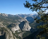
The south wall of the valley has been subject to extensive glacial planing, with all jointed granite completely smoothed away, leaving a stark, featureless unjointed sheer cliff face, as is apparent in the image of Little Yosemite Valley from Washburn Point, above right. The west end and south wall of the canyon are "exceptionally massive, few cliffs anywhere in the Yosemite region exhibit a more complete absence of fractures." This also leads to an almost complete absence of vegetation as well, as there are few opportunities for roothold. The north wall in contrast, and similarly to the north wall of Yosemite Valley, has been subject to much less glacial planing and is much more differentiated and vegetated.
is a granite dome
in Yosemite National Park
, California
, USA which lies at the extreme northwestern margin of Little Yosemite Valley. It lies adjacent, to the north of Nevada Fall
, on the John Muir Trail
at 37°43′43"N 119°31′57"W. It rises 1700 feet (518.2 m) feet from the base of Nevada Fall
to a peak elevation of 7076 ft (2,157 m). A smaller, mesa-like dome called Mount Broderick stands immediately adjacent to Liberty Cap. Together, they form a barrier on the north side of the mouth of Little Yosemite Valley.
Both Liberty Cap and Mount Broderick are roches moutonnées
, features that protruded above or resisting being overridden by successive Merced River glaciers because they are made of massive unjointed granite sufficiently resistant to glacial erosive power, leaving them prominent in the post-glacial landscape. Both features are glacially polished on their glacier-facing side and ragged on their leeward side.
is a granite dome in Yosemite National Park located at the northwestern end of Little Yosemite Valley at 37°44′45.6"N 119°31′59.4"W
— possibly Yosemite's most familiar rock formation
. The granite
crest rises more than 4737 ft (1,444 m) above the Yosemite Valley
floor at Tenaya Canyon
and 2686 feet (819 m) above the floor of Little Yosemite Valley.
The trail to Half Dome branches to the north from the main Little Yosemite Valley trail near the ranger station, out houses and campground.
. It is likely that these moraines represent the highest level attained by glacial ice in Little Yosemite Valley. Although it is about as high as Sentinel Dome
Moraine Dome is dwarfed to relative insignificance by its proximity to the bulk and elevation of Clouds Rest
to the north.
The south western margin of Moraine Dome is wrapped by a broad, striped granite apron with an approximately 40° slope that appears to rise some 500 ft (152 m) from the valley floor.
 Sugar Loaf Dome is a granite dome in Yosemite National Park
at the north eastern head of the Little Yosemite Valley at 37°44′27.47"N 119°28′44.94"W which rises to 7697 feet (2,346 m) AMSL.
Although Sugar Loaf Dome has been repeatedly subject to glaciation, the core of this spur has resisted the icy onslaughts because what remains today is massive throughout except for one master joint, horizontal in character. Post-glaciation, Sugar Loaf Dome retains a 1,300 feet rise over, and its shoulder perturbs the course of the Merced River and provides the relief over which the river descends into Little Yosemite via Cascade Fall.
over the glacially polished granite
saddle between Sugar Loaf and Bunnell Point into a delightful pool at the eastern head of Little Yosemite Valley. This cascade is often mistaken for Bunnell Cascade which is located between the Lost Valley
and Echo Valley at 37°44′43.87"N 119°28′14.95"W.
. Bunnell Point rises to 8173 feet (2,491 m) AMSL. Bunnell Point is located at 37°44′19.734"N 119°28′2.568"W comprising the southeast margin of Little Yosemite Valley.
, of which Cascade Cliffs comprises the northern flank. In few other places in the Yosemite region is the granite more continuously massive than in the Cascade Cliffs. Only one horizontal master joint divides the rock (in the lower left) The scales on the cliffs are merely surficial features due to exfoliation. The dark streaks indicate the paths followed by the ribbon cascades which descend from the upland in the spring, when the snow is melting, and from which the cliffs take their name. There are two wide, relatively short yet quite deep arches at the bottom of the cliff.
The trail is largely forested, with two notable areas of exposure, the first 0.1 mile (0.160934 km) on the approach to the southwest buttress of Moraine Dome and the second, 0.25 mile (0.402335 km) of burned forest, at approximately 2.3 miles (4 km) above Nevada Fall, across from Cascade Cliffs.
Fires are allowed in the two communal campfire rings just outside the campground. Potable (drinking) water is not available at the campground. River water is available nearby, at the Merced River. The river is the only water source for the area. Little Yosemite Valley Ranger Station is staffed during summer. A composting toilet is available for use near the campground 37°44′0.45"N 119°30′55.99"W
The Park Service provides communal food lockers at the campground in which to store food, toiletries, and trash safe from abundant hungry black bears
that frequent Little Yosemite.
Merced River
The Merced River , in the central part of the U.S. state of California, is a -long tributary of the San Joaquin River flowing from the Sierra Nevada into the Central Valley. It is most well known for its swift and steep course through the southern part of Yosemite National Park, and the...
drainage from the Yosemite Valley
Yosemite Valley
Yosemite Valley is a glacial valley in Yosemite National Park in the western Sierra Nevada mountains of California, carved out by the Merced River. The valley is about long and up to a mile deep, surrounded by high granite summits such as Half Dome and El Capitan, and densely forested with pines...
in Yosemite National Park
Yosemite National Park
Yosemite National Park is a United States National Park spanning eastern portions of Tuolumne, Mariposa and Madera counties in east central California, United States. The park covers an area of and reaches across the western slopes of the Sierra Nevada mountain chain...
. The Merced River meanders
Meander
A meander in general is a bend in a sinuous watercourse. A meander is formed when the moving water in a stream erodes the outer banks and widens its valley. A stream of any volume may assume a meandering course, alternately eroding sediments from the outside of a bend and depositing them on the...
through the 3.5 mi (5.6 km) long flat valley, draining out over Nevada Fall
Nevada Fall
Nevada Fall is a high waterfall on the Merced River in Yosemite National Park, California. It is located below the granite dome, Liberty Cap, at the west end of Little Yosemite Valley. The waterfall is widely recognized by its "bent" shape, in which the water free-falls for roughly the first third...
and Vernal Fall before emptying into the main Yosemite Valley. It can be reached by a day hike from the main valley, and is the most popular area in the Yosemite Wilderness. The Valley provides access to nearby destinations such as the back side of Half Dome
Half Dome
Half Dome is a granite dome in Yosemite National Park, located in northeastern Mariposa County, California, at the eastern end of Yosemite Valley — possibly Yosemite's most familiar rock formation. The granite crest rises more than above the valley floor....
, Clouds Rest
Clouds Rest
Clouds Rest is a mountain in Yosemite National Park east northeast of Yosemite Village, California. Although there are many peaks in the park having far greater elevation, Clouds Rest's proximity to the valley gives it a very high degree of visual prominence....
and the High Sierra Camp
High Sierra Camps
The High Sierra Camps are nine rustic lodging facilities located in two national parks and a national monument in California's Sierra Nevada mountain range. Open most years from June or July to September, they are staffed camps with tent cabins and food service facilities. The backcountry camps...
at Merced Lake.
Little Yosemite Valley is a tread on the glacial stairway of the Merced River that runs from Yosemite Valley up to Mount Lyell, gaining some 7600 ft (2,316 m) of vertical elevation over 21 mi (34 km) and is situated some 2000 ft (610 m) in elevation above Yosemite Valley proper.
Geology
The north wall of Little Yosemite has not been subject to the same kinds of glacial planing as the south wall because the granite rocks of Moraine Dome and Sugar Bowl Dome are tougher and more resistant. This is remarkable considering that it is likely that Little Yosemite was not only scoured repeatedly by glaciers that were wholly contained by the canyon, but also overrun by glaciers that overflowed the Merced canyon and spread widely into surrounding uplands with occasional surges of ice contributed over the pass from the overflowing Tuolumne RiverTuolumne River
The Tuolumne River is a California river that flows nearly from the central Sierra Nevada to the San Joaquin River in the Central Valley...
basin. These rocks were thus subject to tremendous gravitational and flow forces yet retain a remarkable degree of integrity, eroding almost exclusively and superficially along exfoliation joints.
The south wall of the valley has been subject to extensive glacial planing, with all jointed granite completely smoothed away, leaving a stark, featureless unjointed sheer cliff face, as is apparent in the image of Little Yosemite Valley from Washburn Point, above right. The west end and south wall of the canyon are "exceptionally massive, few cliffs anywhere in the Yosemite region exhibit a more complete absence of fractures." This also leads to an almost complete absence of vegetation as well, as there are few opportunities for roothold. The north wall in contrast, and similarly to the north wall of Yosemite Valley, has been subject to much less glacial planing and is much more differentiated and vegetated.
Liberty Cap and Mount Broderick
Liberty CapLiberty Cap (California)
Liberty Cap is a granite dome in Yosemite National Park, California, USA which lies at the extreme northwestern margin of Little Yosemite Valley. It lies adjacent, to the north of Nevada Fall, on the John Muir Trail. It rises feet from the base of Nevada Fall to a peak elevation of . A smaller,...
is a granite dome
Granite dome
A granite dome is a dome of granite, formed by exfoliation.-Formation:Granite forms plutons of igneous rock several kilometers below the surface as magma slowly cools and crystallizes. The granite is under great overhead pressure....
in Yosemite National Park
Yosemite National Park
Yosemite National Park is a United States National Park spanning eastern portions of Tuolumne, Mariposa and Madera counties in east central California, United States. The park covers an area of and reaches across the western slopes of the Sierra Nevada mountain chain...
, California
California
California is a state located on the West Coast of the United States. It is by far the most populous U.S. state, and the third-largest by land area...
, USA which lies at the extreme northwestern margin of Little Yosemite Valley. It lies adjacent, to the north of Nevada Fall
Nevada Fall
Nevada Fall is a high waterfall on the Merced River in Yosemite National Park, California. It is located below the granite dome, Liberty Cap, at the west end of Little Yosemite Valley. The waterfall is widely recognized by its "bent" shape, in which the water free-falls for roughly the first third...
, on the John Muir Trail
John Muir Trail
The John Muir Trail is a long-distance trail in the Sierra Nevada mountain range of California, running between the northern terminus at Happy Isles in Yosemite Valley and the southern terminus located on the summit of Mount Whitney . For almost all of its length, the trail is in the High Sierra...
at 37°43′43"N 119°31′57"W. It rises 1700 feet (518.2 m) feet from the base of Nevada Fall
Nevada Fall
Nevada Fall is a high waterfall on the Merced River in Yosemite National Park, California. It is located below the granite dome, Liberty Cap, at the west end of Little Yosemite Valley. The waterfall is widely recognized by its "bent" shape, in which the water free-falls for roughly the first third...
to a peak elevation of 7076 ft (2,157 m). A smaller, mesa-like dome called Mount Broderick stands immediately adjacent to Liberty Cap. Together, they form a barrier on the north side of the mouth of Little Yosemite Valley.
Both Liberty Cap and Mount Broderick are roches moutonnées
Roche moutonnée
In glaciology, a roche moutonnée is a rock formation created by the passing of a glacier. When a glacier erodes down to bedrock, it can form tear-drop shaped hills that taper in the up-ice direction.-Name:...
, features that protruded above or resisting being overridden by successive Merced River glaciers because they are made of massive unjointed granite sufficiently resistant to glacial erosive power, leaving them prominent in the post-glacial landscape. Both features are glacially polished on their glacier-facing side and ragged on their leeward side.
Half Dome
Half DomeHalf Dome
Half Dome is a granite dome in Yosemite National Park, located in northeastern Mariposa County, California, at the eastern end of Yosemite Valley — possibly Yosemite's most familiar rock formation. The granite crest rises more than above the valley floor....
is a granite dome in Yosemite National Park located at the northwestern end of Little Yosemite Valley at 37°44′45.6"N 119°31′59.4"W
— possibly Yosemite's most familiar rock formation
Rock formations in the United States
The following is a partial list of rock formations in the United States, by state:-Arizona:*Canyon de Chelly National Monument**Spider Rock*Chiricahua National Monument**Duck on a Rock**Organ Pipe**Mushroom Rock**Sea Captain*Monument Valley...
. The granite
Granite
Granite is a common and widely occurring type of intrusive, felsic, igneous rock. Granite usually has a medium- to coarse-grained texture. Occasionally some individual crystals are larger than the groundmass, in which case the texture is known as porphyritic. A granitic rock with a porphyritic...
crest rises more than 4737 ft (1,444 m) above the Yosemite Valley
Yosemite Valley
Yosemite Valley is a glacial valley in Yosemite National Park in the western Sierra Nevada mountains of California, carved out by the Merced River. The valley is about long and up to a mile deep, surrounded by high granite summits such as Half Dome and El Capitan, and densely forested with pines...
floor at Tenaya Canyon
Tenaya Canyon
Tenaya Canyon is a dramatic and dangerous canyon in Yosemite National Park, California, USA, that runs from the outlet of Tenaya Lake 10 miles down to Yosemite Valley, carrying water in Tenaya Creek through a series of spectacular cascades and pools and thence into a deep canyon below Cloud's Rest,...
and 2686 feet (819 m) above the floor of Little Yosemite Valley.
The trail to Half Dome branches to the north from the main Little Yosemite Valley trail near the ranger station, out houses and campground.
Moraine Dome
Moraine Dome is a granite dome in Yosemite National Park along the northern margin of Little Yosemite Valley at 37°44′35.15"N 119°29′24.49"W which rises to an elevation of 8036 feet (2,449 m) AMSL, 1906 feet (581 m) above the Merced River. Moraine Dome is notable because the presence of lateral moraines from the Merced GlacierGlacier
A glacier is a large persistent body of ice that forms where the accumulation of snow exceeds its ablation over many years, often centuries. At least 0.1 km² in area and 50 m thick, but often much larger, a glacier slowly deforms and flows due to stresses induced by its weight...
. It is likely that these moraines represent the highest level attained by glacial ice in Little Yosemite Valley. Although it is about as high as Sentinel Dome
Sentinel Dome
Sentinel Dome is a granite dome in Yosemite National Park, United States. It lies on the south wall of Yosemite Valley, southwest of Glacier Point and northeast of Profile Cliff....
Moraine Dome is dwarfed to relative insignificance by its proximity to the bulk and elevation of Clouds Rest
Clouds Rest
Clouds Rest is a mountain in Yosemite National Park east northeast of Yosemite Village, California. Although there are many peaks in the park having far greater elevation, Clouds Rest's proximity to the valley gives it a very high degree of visual prominence....
to the north.
The south western margin of Moraine Dome is wrapped by a broad, striped granite apron with an approximately 40° slope that appears to rise some 500 ft (152 m) from the valley floor.
Sugar Loaf
Yosemite National Park
Yosemite National Park is a United States National Park spanning eastern portions of Tuolumne, Mariposa and Madera counties in east central California, United States. The park covers an area of and reaches across the western slopes of the Sierra Nevada mountain chain...
at the north eastern head of the Little Yosemite Valley at 37°44′27.47"N 119°28′44.94"W which rises to 7697 feet (2,346 m) AMSL.
Although Sugar Loaf Dome has been repeatedly subject to glaciation, the core of this spur has resisted the icy onslaughts because what remains today is massive throughout except for one master joint, horizontal in character. Post-glaciation, Sugar Loaf Dome retains a 1,300 feet rise over, and its shoulder perturbs the course of the Merced River and provides the relief over which the river descends into Little Yosemite via Cascade Fall.
Cascade Fall
Cascade Fall at 37°44′11.32"N 119°28′53.13"W, elevation 6225 feet (1,897 m) AMSL tumbles via a Water WheelWater wheel
A water wheel is a machine for converting the energy of free-flowing or falling water into useful forms of power. A water wheel consists of a large wooden or metal wheel, with a number of blades or buckets arranged on the outside rim forming the driving surface...
over the glacially polished granite
Granite
Granite is a common and widely occurring type of intrusive, felsic, igneous rock. Granite usually has a medium- to coarse-grained texture. Occasionally some individual crystals are larger than the groundmass, in which case the texture is known as porphyritic. A granitic rock with a porphyritic...
saddle between Sugar Loaf and Bunnell Point into a delightful pool at the eastern head of Little Yosemite Valley. This cascade is often mistaken for Bunnell Cascade which is located between the Lost Valley
Lost Valley
Lost Valley is a valley to the north of Gin Cove and west of Patalamon Mesa on James Ross Island. So named following British Antarctic Survey geological work, 1981–83, in association with Hidden Lake....
and Echo Valley at 37°44′43.87"N 119°28′14.95"W.
Bunnell Point
Bunnell Point is a granite dome summit in Mariposa County, CaliforniaMariposa County, California
Mariposa County is a county in the U.S. state of California, located in the western foothills of the Sierra Nevada mountains. It lies north of Fresno, east of Merced, and southeast of Stockton. As of the 2010 census, the population was 18,251 up from 17,130 at the 2000 census...
. Bunnell Point rises to 8173 feet (2,491 m) AMSL. Bunnell Point is located at 37°44′19.734"N 119°28′2.568"W comprising the southeast margin of Little Yosemite Valley.
Cascade Cliffs
Cascade Cliffs is a wall of unjointed granite that rises to 8170 feet (2,490 m) AMSL, 1930 feet (588 m) above the Merced River and make up the southern wall of Little Yosemite Valley at 37°43′27.732"N 119°29′13.5594"W, 1.6 miles (3 km) southwest of Bunnell Point and 2.4 miles (4 km) northeast of Mount Starr KingMount Starr King (California)
Mount Starr King is a symmetrical granite dome in Yosemite National Park, whose highest point is above sea level.Climbing Starr King's dome requires technical skills or equipment and is rated class 5 in the Yosemite Decimal System....
, of which Cascade Cliffs comprises the northern flank. In few other places in the Yosemite region is the granite more continuously massive than in the Cascade Cliffs. Only one horizontal master joint divides the rock (in the lower left) The scales on the cliffs are merely surficial features due to exfoliation. The dark streaks indicate the paths followed by the ribbon cascades which descend from the upland in the spring, when the snow is melting, and from which the cliffs take their name. There are two wide, relatively short yet quite deep arches at the bottom of the cliff.
Trail
The Merced River enters Little Yosemite Valley at 6185 feet (1,885 m) at the pool at the base of the cascsde and leaves the valley at 5907 feet (1,800 m) for a total elevation difference of 278 feet (85 m) over a trail length of 3.25 miles (5 km).The trail is largely forested, with two notable areas of exposure, the first 0.1 mile (0.160934 km) on the approach to the southwest buttress of Moraine Dome and the second, 0.25 mile (0.402335 km) of burned forest, at approximately 2.3 miles (4 km) above Nevada Fall, across from Cascade Cliffs.
Campground
The hike-in campground here is a little under 4 miles (6.5 km) from the trailhead in Yosemite Valley and about 3.5 miles (5.5 km) from the summit of Half Dome at 37°43′57.43"N 119°30′51.68"W.Fires are allowed in the two communal campfire rings just outside the campground. Potable (drinking) water is not available at the campground. River water is available nearby, at the Merced River. The river is the only water source for the area. Little Yosemite Valley Ranger Station is staffed during summer. A composting toilet is available for use near the campground 37°44′0.45"N 119°30′55.99"W
The Park Service provides communal food lockers at the campground in which to store food, toiletries, and trash safe from abundant hungry black bears
American black bear
The American black bear is a medium-sized bear native to North America. It is the continent's smallest and most common bear species. Black bears are omnivores, with their diets varying greatly depending on season and location. They typically live in largely forested areas, but do leave forests in...
that frequent Little Yosemite.