
Sierra National Forest
Encyclopedia
United States National Forest
National Forest is a classification of federal lands in the United States.National Forests are largely forest and woodland areas owned by the federal government and managed by the United States Forest Service, part of the United States Department of Agriculture. Land management of these areas...
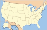
located on the western slope of central Sierra Nevada in the state of California
California
California is a state located on the West Coast of the United States. It is by far the most populous U.S. state, and the third-largest by land area...
. The forest is known for its mountain scenery and natural resources. Forest headquarters are located in Clovis, California
Clovis, California
Clovis is a city in Fresno County, California, United States, northeast of Fresno. The population is estimated to be 97,218 as of September, 2011. Clovis is located northeast of downtown Fresno, at an elevation of 361 feet .-History:...
. There are local ranger
National Park Ranger
National Park Service Rangers are among the uniformed employees charged with protecting and preserving areas set aside in the National Park System by the United States Congress and/or the President of the United States...
district offices in North Fork
North Fork, California
North Fork is an unincorporated community in Madera County, California. It is located east of Raymond, at an elevation of 2638 feet .It is miles south east of Bass Lake and from Oakhurst. North Fork is also home of the Mono Indian Museum and the starting point of the Sierra scenic byway...
and Prather
Prather, California
Prather is an unincorporated community in Fresno County, California. It is located northeast of Fresno, at an elevation of 1657 feet ....
.
History
This was the second National Forest created in California and the largest at the time. It covered over six million acres (24,000 km2) of the Sierra Nevada and was about four times the average area of typical California National Forests. Originally it embraced parts of eight counties from TuolumneTuolumne County, California
Tuolumne County is a county in the Sierra Nevada of the U.S. state of California. The northern half of Yosemite National Park is located in the eastern part of the county. As of the 2010 census, the population was 55,365, up from 54,501 at the 2000 census...
on the north to Kern
Kern County, California
Spreading across the southern end of the California Central Valley, Kern County is the fifth-largest county by population in California. Its economy is heavily linked to agriculture and to petroleum extraction, and there is a strong aviation and space presence. Politically, it has generally...
on the south and Mono
Mono County, California
Mono County is a county located in the east central portion of the U.S. state of California, to the east of the Sierra Nevada between Yosemite National Park and Nevada. As of the 2010 census, the population was 14,202, up from 12,853 at the 2000 census...
and Inyo
Inyo County, California
-National protected areas:* Death Valley National Park * Inyo National Forest * Manzanar National Historic Site-Major highways:* U.S. Route 6* U.S. Route 395* State Route 127* State Route 136* State Route 168* State Route 178...
on the east. Initially its name was descriptive, but later when the Sierra was divided into different units this was no longer the case.
President Harrison proclaimed the Sierra Forest Reserve on February 14, 1893. Four years later the south half became a separate unit and was named Sierra South during the "forest reserves" era. This designation was dropped after the administrative transition to the National Forests on March 4, 1907. the Sequoia National Forest
Sequoia National Forest
Sequoia National Forest is located in the southern Sierra Nevada mountains of California. The U.S. National Forest is named for the majestic Giant Sequoia trees which populate 38 distinct groves within the boundaries of the forest....
on July 1, 1908 Kings Canyon
Kings Canyon National Park
Kings Canyon National Park is a National Park in the southern Sierra Nevada, east of Fresno, California. The park was established in 1940 and covers...
and Sequoia
Sequoia National Park
Sequoia National Park is a national park in the southern Sierra Nevada east of Visalia, California, in the United States. It was established on September 25, 1890. The park spans . Encompassing a vertical relief of nearly , the park contains among its natural resources the highest point in the...
National Parks were established from this south portion of Sierra National Forest. Eastern portions of Sierra NF were used for the Inyo
Inyo National Forest
Inyo National Forest is a federally administered forest in the United States. The forest covers parts of the eastern Sierra Nevada of California, and the White Mountains of California and Nevada. It contains two wilderness areas: the John Muir Wilderness and the Ansel Adams Wilderness...
and Toiyabe National Forests; northern portions were used for the Yosemite National Park and the Stanislaus National Forest
Stanislaus National Forest
Stanislaus National Forest contains in four counties in the Sierra Nevada Mountains of Northern California. It was established on February 22, 1897, making it one of the oldest national forests...
.
The first timber sale on a California National Forest took place in the Sierra NF by the General Land Office
General Land Office
The General Land Office was an independent agency of the United States government responsible for public domain lands in the United States. It was created in 1812 to take over functions previously conducted by the United States Department of the Treasury...
in 1899.
Geography
Sierra covers in descending order of forestland area, the eastern portions of FresnoFresno County, California
Fresno County is a county located in the Central Valley of the U.S. state of California, south of Stockton and north of Bakersfield. As of the 2010 census, it is the tenth most populous county in California with a population of 930,450, and the sixth largest in size with an area of . The county...
, Madera
Madera County, California
Madera County is a county of the U.S. state of California, located in the Central Valley and the Sierra Nevada north of Fresno County. It comprises the Madera-Chowchilla, CA Metropolitan Statistical Area. As of the 2010 census the population was 150,865...
, and Mariposa
Mariposa County, California
Mariposa County is a county in the U.S. state of California, located in the western foothills of the Sierra Nevada mountains. It lies north of Fresno, east of Merced, and southeast of Stockton. As of the 2010 census, the population was 18,251 up from 17,130 at the 2000 census...
counties, adjacent to the southern part of Yosemite National Park
Yosemite National Park
Yosemite National Park is a United States National Park spanning eastern portions of Tuolumne, Mariposa and Madera counties in east central California, United States. The park covers an area of and reaches across the western slopes of the Sierra Nevada mountain chain...
. It includes more than 1300000 acre (2,031.3 sq mi; 5,260.9 km²), at altitudes ranging from 900 to 13986 ft (274.3 to 4,262.9 m) in elevation. The terrain includes rolling, oak
Oak
An oak is a tree or shrub in the genus Quercus , of which about 600 species exist. "Oak" may also appear in the names of species in related genera, notably Lithocarpus...
-covered foothills, heavily forest
Forest
A forest, also referred to as a wood or the woods, is an area with a high density of trees. As with cities, depending where you are in the world, what is considered a forest may vary significantly in size and have various classification according to how and what of the forest is composed...
ed middle elevation slopes and the alpine
Tundra
In physical geography, tundra is a biome where the tree growth is hindered by low temperatures and short growing seasons. The term tundra comes through Russian тундра from the Kildin Sami word tūndâr "uplands," "treeless mountain tract." There are three types of tundra: Arctic tundra, alpine...
landscape of the High Sierra.
Boundaries
The forest's boundary starts clockwise at the intersections of the Merced RiverMerced River
The Merced River , in the central part of the U.S. state of California, is a -long tributary of the San Joaquin River flowing from the Sierra Nevada into the Central Valley. It is most well known for its swift and steep course through the southern part of Yosemite National Park, and the...
, The Sweetwater Creek and the HWY 140
California State Route 140
State Route 140 is a state highway in the U.S. state of California, 102 miles in length. It begins in the San Joaquin Valley at Interstate 5 near Gustine, and runs east into the Sierra Nevada, terminating in Yosemite National Park....
then moves east following the Merced River canyon to the border with the Yosemite National Park near El Portal
El Portal, California
El Portal is a census-designated place in Mariposa County, California. It is located west-southwest of Yosemite Village, at an elevation of 1939 feet . The population was 474 at the 2010 census....
. Then it follows the parks southern boundary till it reaches the Inyo National forest near Electra Peak. From there it travels south to its border with the Kings Canyon National park near Mt Goethe. It then follows the park's northern border, then heads south to the Kings River near Deer Canyon. From there it moves down the Kings River canyon east; south of the river is the Sequoia National Forest. When it reaches Pine Flat Lake near Trimmer, it turns north towards Tollhouse
Tollhouse, California
Tollhouse is an unincorporated community in Fresno County, California. It lies at an elevation of 1919 feet . Tollhouse is located in the Sierra Nevadas, southwest of Shaver Lake....
and continues on to Auberry
Auberry, California
Auberry is a census-designated place in Fresno County, California, United States. The population was 2,369 at the 2010 census, up from 2,053 at the 2000 census...
. From there the NF moves on to North Fork
North Fork, California
North Fork is an unincorporated community in Madera County, California. It is located east of Raymond, at an elevation of 2638 feet .It is miles south east of Bass Lake and from Oakhurst. North Fork is also home of the Mono Indian Museum and the starting point of the Sierra scenic byway...
, then west to form a small finger towards Coarsegold
Coarsegold, California
Coarsegold is a census-designated place in Madera County, California. It is located south-southwest of Yosemite Forks, at an elevation of 2218 feet...
. Finally, the boundary travels north to Yosemite Forks and moves west towards Miami Mountain, then heads north to return to the Merced River.
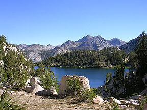
Recreation
The forest includes a number of scenic attractions, including Fresno DomeFresno Dome
Fresno Dome is a dominant granite dome rising in isolation above the forest of Soquel Meadow in the Sierra National Forest in Madera County, California....
and Nelder Grove
Nelder Grove
Nelder Grove is a sequoia grove located in the Sierra National Forest, Madera County, California. It is a 1540 acre tract containing over 100 mature Giant Sequoias. It also contains a number of sequoia stumps, left over from when the area was logged prior to its acquisition by the United States...
. Several reservoirs offer fishing, including Bass Lake
Bass Lake, California
Bass Lake is a freshwater artificial lake in the Sierra National Forest, of Madera County, California, approximately south of the entrance to Yosemite National Park. The lake is formed by the construction of the Crane Valley Dam across Willow Creek, a tributary to the San Joaquin River, and is...
, Wishon Reservoir, and Courtright Reservoir
Courtright Reservoir
Courtright Reservoir is a reservoir in Fresno County, California. The reservoir is at an elevation of 8,170 feet in the Sierra National Forest, in the Sierra Nevada Mountain Range. The reservoir is formed by Courtright Dam on Helms Creek and has a capacity of . The dam is composed of rock-fill and...
. Also, there are numerous hiking opportunities in wilderness areas: Ansel Adams
Ansel Adams Wilderness
The Ansel Adams Wilderness is a wilderness area in the Sierra Nevada of California, USA. The wilderness is part of the Sierra and Inyo National Forests. The wilderness spans...
, John Muir
John Muir Wilderness
The John Muir Wilderness is a wilderness area that extends along the crest of the Sierra Nevada of California, USA for , in the Inyo and Sierra National Forests. Established in 1964 by the Wilderness Act and named for naturalist John Muir, it contains...
, Dinkey Lakes
Dinkey Lakes Wilderness
The Dinkey Lakes Wilderness is a federally designated wilderness area located northeast of Fresno, in the state of California, USA. It comprises within the Sierra National Forest and was added to the National Wilderness Preservation System by the California Wilderness Act of 1984.Elevations...
, Kaiser
Kaiser Wilderness
The Kaiser Wilderness is a federally designated wilderness protected area located northeast of Fresno in the state of California, USA. It was added to the National Wilderness Preservation System by the United States Congress on October 19, 1976...
, and Monarch
Monarch Wilderness
The Monarch Wilderness is a federally designated wilderness area located 70 miles east of Fresno, California, in the Sierra Nevada mountain range. It encompasses within both the Sequoia National Forest and the Sierra National Forest and is managed by the United States Forest Service...
. It also has a ski area, Sierra Summit Ski Area, that operates under a special use permit.
Administration
The Sierra National Forest is located within the Pacific southwest region of the US Forest Service. The Forest is Divided into three Ranger DistrictsBass lake Ranger District is North and West of the San Joaquin River
San Joaquin River
The San Joaquin River is the largest river of Central California in the United States. At over long, the river starts in the high Sierra Nevada, and flows through a rich agricultural region known as the San Joaquin Valley before reaching Suisun Bay, San Francisco Bay, and the Pacific Ocean...
. Its Ranger District office is located at 57003 Road 225 North Fork, California
North Fork, California
North Fork is an unincorporated community in Madera County, California. It is located east of Raymond, at an elevation of 2638 feet .It is miles south east of Bass Lake and from Oakhurst. North Fork is also home of the Mono Indian Museum and the starting point of the Sierra scenic byway...
, CA 93643. there are 36 camp sites, 17 picnic sites, 7 Off Highway Vehicle Trails, 10 trails, it includes the Forest Service Offices of Oakhurst (41969 Hwy 41, Oakhurst, California
Oakhurst, California
Oakhurst is a census-designated place in Madera County, California, south of the entrance to Yosemite National Park, in the foothills of the Sierra Nevada mountain range. Oakhurst is located on the Fresno River south-southwest of Yosemite Forks, at an elevation of 2274 feet...
93644), and Mariposa (5158 Suite A Highway 140 Mariposa, California
Mariposa, California
Mariposa is a census-designated place in and the county seat of Mariposa County, California, United States. The population was 2,173 at the 2010 census, up from 1,373 at the 2000 census. Its name is Spanish for "butterfly", after the flocks of Monarchs seen overwintering there by early...
95338) The High Sierra visitor information Station near Mono Hot Springs on the Kaiser Pass Road, Eastwood visitor information center at Hwy 168 and Kaiser Pass Road at Huntington Lake, Dinkey Creek visitor information center in the area of, and the Clover Meadow Wilderness Office in the area of.
High Sierra Ranger District South and East of the San Joaquin River; it has its Ranger District office out of Prather, California
Prather, California
Prather is an unincorporated community in Fresno County, California. It is located northeast of Fresno, at an elevation of 1657 feet ....
. This district contains 30 camp sites, 11 picnic sites, and 13 Off Highway Vehicle Trails.
Supervisor's Office (an administrative Unit) which contains the Sierra National Forest's Supervisor's office (1600 Tollhouse Rd Clovis, California
Clovis, California
Clovis is a city in Fresno County, California, United States, northeast of Fresno. The population is estimated to be 97,218 as of September, 2011. Clovis is located northeast of downtown Fresno, at an elevation of 361 feet .-History:...
, 93611). two Community Visitor Centers the Mariposa Interagency Visitor Center (5158 Highway 140 Mariposa, California 95338) and the Yosemite Sierra Visitor Bureau (41969 Highway 41, Oakhurst, California 93644). and the Fresno Air Attack Base
Fresno Air Attack Base
The Fresno Air Attack Base was established in 1955 By the US Forest Service, Sierra National Forest and is located at the Fresno Yosemite International Airport. The US Forest Service leases office space to the California Department of Forestry and Fire Protection's Fresno/Kings Unit...
which is co located with the Sierra National Forest Emergency Communications Center (2307 and 2309 N Clovis ave. Fresno, California
Fresno, California
Fresno is a city in central California, United States, the county seat of Fresno County. As of the 2010 census, the city's population was 510,365, making it the fifth largest city in California, the largest inland city in California, and the 34th largest in the nation...
93727) on the Fresno Yosemite International Airport
Fresno Yosemite International Airport
Fresno Yosemite International Airport , formerly known as Fresno Air Terminal, is a joint civil-military public airport located in eastern Fresno, in Fresno County, California. The airport is more than south of Yosemite National Park on California State Route 41. The airport covers and has two...
In addition, the forest has a close relationship with the Teakettle Experimental Forest
Teakettle Experimental Forest
The Teakettle Experimental Forest is a part of the Sierra National Forest that is set aside for research into forest ecology. The forest is located east of Fresno, California, between Yosemite and Kings Canyon National Parks...
which is deep inside the forest and the San Joaquin Experimental Range
San Joaquin Experimental Range
The San Joaquin Experimental Range is an ecosystem research experimental area in the foothills of the Sierra Nevada. The range is located in O'Neals, California, outside of the Sierra National Forest about north of Fresno, California....
which is just outside the forest boundary's. They both fall in the Pacific southwest Research Station which is based in Berkeley, California
Berkeley, California
Berkeley is a city on the east shore of the San Francisco Bay in Northern California, United States. Its neighbors to the south are the cities of Oakland and Emeryville. To the north is the city of Albany and the unincorporated community of Kensington...
.
Ecology
The ecology of the National Forest are typical for the western side of the southern Sierra Nevada: distributions of species are largely governed by climate, which is strongly dependent on altitude. The ecology can be described by biotic zones, which are marked by either a tree indicator speciesIndicator species
An indicator species is any biological species that defines a trait or characteristic of the environment. For example, a species may delineate an ecoregion or indicate an environmental condition such as a disease outbreak, pollution, species competition or climate change...
, or by a lack of trees. The biotic zones include the foothill woodland zone from 1000 to 3000 ft (304.8 to 914.4 m) (interior live oak
Interior Live Oak
Quercus wislizeni, known by the common names Interior Live Oak, and Sierra Live Oak, is an evergeen oak, highly variable and often shrubby, found in areas of California in the United States. It also occurs south into northern Baja California in Mexico...
), the lower montane zone from 3000 to 7000 ft (914.4 to 2,133.6 m) (Yellow pine
Yellow pine
Yellow pine may refer to the following:*Certain pines in the subgenus Pinus subgenus Pinus:**In American forestry, a term for several closely related species of pine with yellow tinted wood, including the Southern Yellow Pines , and the non-Southern yellow pines and several others...
), the upper montane zone from 7000 to 9000 ft (2,133.6 to 2,743.2 m) (Lodgepole pine
Lodgepole Pine
Lodgepole Pine, Pinus contorta, also known as Shore Pine, is a common tree in western North America. Like all pines, it is evergreen.-Subspecies:...
/Red fir
Red Fir
Abies magnifica, the Red Fir or Silvertip fir, is a western North American fir, native to the mountains of southwest Oregon and California in the United States. It is a high altitude tree, typically occurring at altitude, though only rarely reaching tree line...
), the subalpine zone
Sierra Nevada subalpine zone
The Sierra Nevada subalpine zone refers to a biotic zone below treeline in the Sierra Nevada mountain range of California, United States. This subalpine zone is positioned between the upper montane zone at its lower limit, and tree line at its upper limit.The Sierra Nevada subalpine zone occurs...
from 9000 to 9500 ft (2,743.2 to 2,895.6 m) (Whitebark pine
Whitebark Pine
Pinus albicaulis, known commonly as Whitebark Pine, Pitch Pine, Scrub Pine, and Creeping Pine occurs in the mountains of the Western United States and Canada, specifically the subalpine areas of the Sierra Nevada, the Cascade Range, the Pacific Coast Ranges, and the northern Rocky Mountains –...
), and the alpine zone
Alpine climate
Alpine climate is the average weather for a region above the tree line. This climate is also referred to as mountain climate or highland climate....
from 9500 feet (2,895.6 m) (above the tree line).
In addition, some 383000 acre (598.4 sq mi; 1,549.9 km²) of the forest are old growth, containing Lodgepole Pine
Lodgepole Pine
Lodgepole Pine, Pinus contorta, also known as Shore Pine, is a common tree in western North America. Like all pines, it is evergreen.-Subspecies:...
(Pinus contorta), Red Fir
Red Fir
Abies magnifica, the Red Fir or Silvertip fir, is a western North American fir, native to the mountains of southwest Oregon and California in the United States. It is a high altitude tree, typically occurring at altitude, though only rarely reaching tree line...
(Abies magnifica).
See also
Sierra National Forest index
- Sierra Nation Forest Fire & Aviation ManagementSierra Nation Forest Fire & Aviation ManagementThe Sierra National Forest Fire & Aviation Management team operates in the Sierra National Forest, a United States National Forest located on the western slope of central Sierra Nevada in the U.S...
External links
- USDA Forest Service Sierra National Forest (PD source)