
Maryland Route 213
Encyclopedia
Maryland Route 213 is a 68.25 miles (109.84 km) state highway
located on the Eastern Shore of Maryland
in the United States
. The route runs from Maryland Route 662
in Wye Mills
, Queen Anne's County
north to the Pennsylvania
border in Cecil County
, where it continues into that state as Pennsylvania Route 841
. The route, which is a two-lane undivided highway its entire length, passes through mostly rural areas as well as the communities of Centreville
, Chestertown
, Galena
, Cecilton
, Chesapeake City
, and Elkton
. MD 213 intersects many routes including U.S. Route 50
near Wye Mills, U.S. Route 301
near Centreville, and U.S. Route 40
in Elkton. It crosses over the Chesapeake and Delaware Canal
in Chesapeake City on the Chesapeake City Bridge
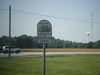
. Maryland Route 213 is designated by the state as the Chesapeake Country Scenic Byway
between the southern terminus and Chesapeake City with the portion north of Maryland Route 18
in Centreville a National Scenic Byway
. In addition, the route is also considered part of the Atlantic to Appalachians Scenic Byway between Chesapeake City and Maryland Route 273
in Fair Hill.
The route was initially designated as U.S. Route 213 in 1926 when the U.S. Highway System was established, running from Ocean City
to US 40 in Elkton. By 1940, it was realigned to the US 50 corridor between Mardela Springs and Easton, having previously followed Maryland Route 313
, Maryland Route 14
, and Maryland Route 331
between these two points, and Maryland Route 280 was designated along current MD 213 north of US 40. In 1949, US 50 replaced US 213 south of Wye Mills. The route was then downgraded to MD 213 by 1975, and was subsequently extended to the Pennsylvania border along the alignment of MD 280, whose signs consequently were taken down.
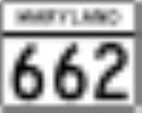
 Maryland Route 213 begins at an intersection with Maryland Route 662
(Wye Mills Road) in Wye Mills
, Queen Anne's County
, heading to the north on College Drive, a two-lane undivided road with a 40 mph (64.4 km/h) speed limit. From the southern terminus, MD 213 is designated by the state as the Chesapeake Country Scenic Byway
. The road heads into rural farmland, passing Chesapeake College
on the left before intersecting U.S. Route 50
(Ocean Gateway). Past this intersection, MD 213 continues north on 55 mph (88.5 km/h) Centreville Road, passing more farms as well as some residences. The route continues into a mix of woods and farmland before intersecting the northern terminus of Maryland Route 309
(Starr Road). A short distance later, the route interchanges with U.S. Route 301
(Blue Star Memorial Highway). Past the US 301 interchange, MD 213 continues through more rural areas before entering Centreville
, where the speed limit drops to 30 mph (48.3 km/h) and it passes some residential and commercial areas. It intersects Maryland Route 18
(4H Park Road). At this intersection, MD 213 becomes a part of the National Scenic Byway
portion of the Chesapeake Country Scenic Byway. Past MD 18, the route continues into residential areas, eventually splitting into a one-way pair
with northbound MD 213 following Commerce Street and southbound MD 213 following Liberty Street. This pairing continues past residences, with the speed limit dropping to 25 mph (40.2 km/h), before heading into the downtown area, where the road intersects Maryland Route 304
(Water Street). Westbound MD 304 secretly joins northbound MD 213 for a concurrency
that lasts until Broadway, where it continues to the west.
MD 213 leaves downtown Centreville, with the speed limit increasing back to 30 mph (48.3 km/h). The one-way pair ends and the route continues north on two-lane undivided Liberty Street, passing by residences and some businesses. At the end of the one-way pair, the route sees an average of 12,912 vehicles daily. It intersects the western terminus of Maryland Route 305
(Hope Road), and passes by more residences as a 30 mph (48.3 km/h) road before becoming 55 mph (88.5 km/h) Church Hill Road, which heads north into a mix of woods and farms with some housing developments. It angles to the northeast and then north through more rural areas, consisting mostly of farm fields with some wooded areas and occasional residences. MD 213 continues in a northeast direction before reaching Church Hill
. Upon reaching Church Hill, the route intersects Maryland Route 19A (South Main Street), which loops to the east of MD 213 to head into the town. Meanwhile, MD 213 bypasses Church Hill to the west, running through woodland, and intersects the western terminus of Maryland Route 300
(Sudlersville Road). The route heads back into farmland and intersects Maryland Route 19
(North Main Street), leaving the Church Hill area. MD 213 continues north through a mix of woods and farms. From here, the route turns northwest through more farmland before it passes some residences and businesses near the intersection with the western terminus of Maryland Route 544
(Mcginnis Road). Past the MD 544 intersection, the road continues through rural areas as a 50 mph (80.5 km/h) road, but residences and businesses start to increase. MD 213 passes through Kingstown
, where the speed limit drops to 30 mph (48.3 km/h) before crossing the Chester River
on a drawbridge
.
 Upon crossing the Chester River, MD 213 enters Chestertown
, Kent County
, where the route heads northwest on Maple Avenue, a 25 mph (40.2 km/h) street through residential areas. It intersects Maryland Route 289
(Cross Street) in the downtown area and turns north onto Washington Avenue at the intersection with Spring Avenue. Washington Avenue carries MD 213 north through residential neighborhoods and passes by Washington College
. Past the college, the route continues past businesses and intersects Maryland Route 291
(Morgnec Road). Past this intersection, the speed limit increases to 40 mph (64.4 km/h) and MD 213 continues through residential and commercial areas. The road leaves Chestertown and becomes Augustine Herman Highway, which is named for Dutch surveyor Augustine Herman
. The speed limit rises to 45 mph (72.4 km/h) as the road heads into farmland with residences along the west side of the road. MD 213 intersects Maryland Route 297
(Worton Road) and the speed limit increases to 55 mph (88.5 km/h) as it heads past more farm fields. The road turns northeast and intersects Maryland Route 561
(Hassenger’s Corner Road). It continues through more rural areas, consisting mostly of farms with some wooded areas before reaching Kennedyville
, where the speed limit decreases to 30 mph (48.3 km/h) and MD 213 passes residences. In Kennedyville, the road crosses over a Maryland & Delaware Railroad line.
Upon leaving Kennedyville, the speed limit becomes 55 mph (88.5 km/h) again and it continues back into agricultural areas. The route makes a turn to the east, with an old bypassed segment remaining as unsigned Maryland Route 855. MD 213 intersects Maryland Route 298
(Browntown Road) and resumes northeast and east again. It intersects unsigned Maryland Route 449 (Shallcross Wharf Road), which connects to Maryland Route 444
(Kentmore Park Road), which MD 213 intersects a short distance later. From here, the route continues east and northeast through more farmland before heading into a mix of farms and woods. The route enters Galena
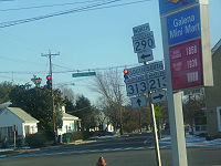
, where it becomes Cross Street and the speed limit drops to 25 mph (40.2 km/h). In the center of town, MD 213 meets Maryland Route 290
and Maryland Route 313
at the intersection with Main Street. Here, MD 290 and MD 313 continue south on Main Street, MD 290 continues east on Cross Street, and MD 213 makes a left turn to head north on Main Street. Main Street passes residences before leaving Galena, where the road becomes Augustine Herman Highway again, with the speed limit rising to 45 mph (72.4 km/h). The road continues through a mix of farms and woods before reaching Georgetown
, where the speed limit decreases to 30 mph (48.3 km/h) and the route passes some homes before crossing the Sassafras River
on a drawbridge near a marina.
upon crossing the Sassafras River, where it continues north through wooded and agricultural areas with some residences, with the speed limit increasing back to 55 mph (88.5 km/h). The route enters Cecilton
, where the speed limit drops to 30 mph (48.3 km/h) and it becomes Bohemia Avenue. In Cecilton, MD 213 passes residences and intersects Maryland Route 282
(Main Street) in the center of town. Upon leaving Cecilton, the name of the road becomes Augustine Herman Highway again and the speed limit climbs back to 55 mph (88.5 km/h). MD 213 passes through farmland, with intermittent woods and rural residences, before crossing over the Bohemia River
. Past the Bohemia River, the road turns northeast through more rural areas before intersecting the western terminus of Maryland Route 310
(Cayots Corner Road). Past MD 310, the route continues through farms and woods with some residences and businesses before heading into the Chesapeake City
area, where residences increase along the road and the speed limit drops to 50 mph (80.5 km/h). Upon reaching Chesapeake City, MD 213 features an interchange with Maryland Route 537
, which provides access to the southern portion of Chesapeake City as well as to Maryland Route 286
and Maryland Route 342
. In Chesapeake City, the Chesapeake Country Scenic Byway ends and MD 213 continues north as a part of the Atlantic to Appalachians Scenic Byway which crosses the state of Maryland. Past this interchange, MD 213 passes over the Chesapeake and Delaware Canal
on the Chesapeake City Bridge
. Upon crossing the canal, the road intersects Maryland Route 285
(Lock Street), which provides access to the northern portion of Chesapeake City. Past MD 285, the route resumes through a mix of woodland and farmland, with residential areas increasing along the road. It approaches the Elkton
area. From here, the speed limit drops to 35 mph (56.3 km/h) and the road heads through residential areas.
MD 213 enters Elkton at the intersection with U.S. Route 40
(Pulaski Highway). Past this intersection, the route heads northwest on Bridge Street, passing through commercial areas, with the speed limit dropping to 25 mph (40.2 km/h). The route intersects Howard Street, which carries the westbound direction of Maryland Route 7
that turns onto northbound MD 213. Westbound MD 7 follows the route to the intersection with Main Street, where it turns left to join with the eastbound direction of MD 7, which continues east of MD 213 on a one-way street. Past MD 7, the road continues north and passes over Amtrak
's Northeast Corridor
before intersecting Maryland Route 545
(Elkton Boulevard). MD 213 continues past commercial areas to the west and residential areas to the east as a 30 mph (48.3 km/h) road before its intersection with Maryland Route 279
(Elkton Road/Newark Avenue). Past the MD 279 intersection, the route leaves Elkton and becomes Singerly Road, a 55 mph (88.5 km/h) which continues past residences. It enters a mix of woods and farms, with the speed limit decreasing to 45 mph (72.4 km/h) and MD 213 passes over Interstate 95
(John F. Kennedy Memorial Highway) and CSX's Philadelphia Subdivision within a short distance of each other. It continues through a mix of farms and residences before the speed limit decreases to 25 mph (40.2 km/h) and the road reaches the Leeds roundabout
with Leeds Road. The speed limit increases back to 45 mph (72.4 km/h) past the roundabout and the route resumes north, intersecting Maryland Route 273
(Telegraph Road) in Fair Hill
west of the Fair Hill Training Center
, where the Atlantic to Appalachians Scenic Byway leaves MD 213 and heads west along MD 273. From here, MD 213 continues northwest and west as Lewisville Road through a mix of rural areas and residences before ending at the Pennsylvania
border. Here, the road continues north as Pennsylvania Route 841
into Lewisville, intersecting the southern terminus of Pennsylvania Route 472
just north of the state line.
 The route was originally designated as U.S. Route 213 with the creation of the U.S. Highway System in 1926, running from Ocean City
north to US 40 in Elkton. The route ran along what is now Maryland Route 707
and Maryland Route 346
to Salisbury
, where it intersected with its parent route, U.S. Route 13
. From Salisbury, US 213 followed the present US 50 corridor to Mardela Springs
, where it turned north on MD 313 and followed that route to Eldorado
. Here, the route ran along present-day Maryland Route 14
and Maryland Route 331
to Easton
, where it continued north along current MD 662 and MD 213 to Elkton. By 1940, US 213 was realigned between Mardela Springs and Easton to follow the present US 50 corridor, crossing the Choptank River
at Cambridge
on the Emerson C. Harrington Bridge that opened in 1935. Also by this time, Maryland Route 280 was designated along present-day MD 213 between US 40 and the Pennsylvania border. On July 28, 1942, the vertical lift bridge carrying US 213 over the Chesapeake and Delaware Canal, built in 1927, was destroyed when the tanker Franz Klasen struck it. The destroyed bridge was replaced by the current Chesapeake City Bridge, which opened in 1949. The approaches to the original bridge are now designated as MD 537 and a western extension of MD 285. In 1949, the route was replaced by U.S. Route 50 between Ocean City and Wye Mills shortly before the opening of the Chesapeake Bay Bridge
, and as a result US 213 no longer crossed US 13. By 1975, US 213 became MD 213, and the route was extended from US 40 to the Pennsylvania border along the former Maryland Route 280.
State highway
State highway, state road or state route can refer to one of three related concepts, two of them related to a state or provincial government in a country that is divided into states or provinces :#A...
located on the Eastern Shore of Maryland
Maryland
Maryland is a U.S. state located in the Mid Atlantic region of the United States, bordering Virginia, West Virginia, and the District of Columbia to its south and west; Pennsylvania to its north; and Delaware to its east...
in the United States
United States
The United States of America is a federal constitutional republic comprising fifty states and a federal district...
. The route runs from Maryland Route 662
Maryland Route 662
Maryland Route 662 is a collection of state highways in the U.S. state of Maryland. These highways are sections of old alignment of U.S. Route 50 between Easton and Wye Mills in Talbot County and Queen Anne's County. MD 662C runs from Easton to Longwoods. MD 662B runs from Longwoods to...
in Wye Mills
Wye Mills, Maryland
Wye Mills is an unincorporated community in Talbot County, Maryland, United States, located at an altitude of 13 feet . It is the home of the Wye Grist Mill which has been in nearly continuous operation since 1682, and Wye Oak and of Chesapeake College.-References:...
, Queen Anne's County
Queen Anne's County, Maryland
Queen Anne's County is a county located on the Eastern Shore of the U.S. state of Maryland.As of 2010, the population was 47,798. Its county seat and most populous municipality is Centreville. The census-designated place of Stevensville is the county's most populous place...
north to the Pennsylvania
Pennsylvania
The Commonwealth of Pennsylvania is a U.S. state that is located in the Northeastern and Mid-Atlantic regions of the United States. The state borders Delaware and Maryland to the south, West Virginia to the southwest, Ohio to the west, New York and Ontario, Canada, to the north, and New Jersey to...
border in Cecil County
Cecil County, Maryland
Cecil County is a county located in the U.S. state of Maryland. It is part of the Delaware Valley. It was named for Cæcilius Calvert, 2nd Baron Baltimore , who was the first Proprietary Governor of the colony of Maryland from 1632 until his death in 1675. The county seat is Elkton. The newspaper...
, where it continues into that state as Pennsylvania Route 841
Pennsylvania Route 841
Pennsylvania Route 841 is a state highway in Chester County, Pennsylvania. The route runs from the Maryland border in the Lewisville section of Elk Township, where it continues as Maryland Route 213, north to Pennsylvania Route 82 in the Doe Run section of West Marlborough Township.-Route...
. The route, which is a two-lane undivided highway its entire length, passes through mostly rural areas as well as the communities of Centreville
Centreville, Maryland
Centreville is an incorporated town in Queen Anne's County, Maryland, United States. Incorporated in 1794, it is the county seat of Queen Anne's County. The population was 1,970 at the 2000 census. The ZIP code is 21617 and the area code is 410. The local telephone exchange is 758...
, Chestertown
Chestertown, Maryland
Chestertown is a town in Kent County, Maryland, United States. The population was 4,746 at the 2000 census. It is the county seat of Kent County. The ZIP code is 21620 and the area codes are 410 and 443...
, Galena
Galena, Maryland
Galena is a town in Kent County, Maryland, United States. The population was 428 at the 2000 census.-Geography:Galena is located at .According to the United States Census Bureau, the town has a total area of , all of it land....
, Cecilton
Cecilton, Maryland
Cecilton is a town in Cecil County, Maryland, United States. The population was 474 at the 2000 census.-Geography:Cecilton is located at .According to the United States Census Bureau, the town has a total area of , all of it land....
, Chesapeake City
Chesapeake City, Maryland
Chesapeake City is a town in Cecil County, Maryland, United States. The population was 787 at the 2000 census.The town was originally named by Bohemian colonist Augustine Herman the Village of Bohemia , but the name was changed in 1839 when the Chesapeake and Delaware Canal was built...
, and Elkton
Elkton, Maryland
The town of Elkton is the county seat of Cecil County, Maryland, United States. The population was 11,893 as of the 2000 census and 14,842 according to current July 2008 census estimates. It is the county seat of Cecil County...
. MD 213 intersects many routes including U.S. Route 50
U.S. Route 50 in Maryland
U.S. Route 50 is a major east–west route of the U.S. Highway system, stretching just over from Ocean City, Maryland on the Atlantic Ocean to West Sacramento, California. In the U.S. state of Maryland, US 50 exists in two sections. The longer of these serves as a major route connecting...
near Wye Mills, U.S. Route 301
U.S. Route 301 in Maryland
U.S. Route 301 in Maryland is a major highway that runs from Delaware to the Governor Harry W. Nice Memorial Bridge into Virginia. It passes through three of Maryland's four main regions: the Eastern Shore, the Baltimore-Washington Metropolitan Area, and Southern Maryland...
near Centreville, and U.S. Route 40
U.S. Route 40 in Maryland
U.S. Route 40 in the U.S. state of Maryland runs from western Maryland to Cecil County in the state's northeastern corner. With a total length of over , it is the longest numbered highway in Maryland. Almost half of the road overlaps with Interstate 68 or Interstate 70, while the old alignment...
in Elkton. It crosses over the Chesapeake and Delaware Canal
Chesapeake and Delaware Canal
The Chesapeake and Delaware Canal is a 14-mile long, 450-foot wide and 40-foot deep ship canal that cuts across the states of Maryland and Delaware, in the United States. It connects the waters of the Delaware River with those of the Chesapeake Bay and the Port of Baltimore...
in Chesapeake City on the Chesapeake City Bridge
Chesapeake City Bridge
The Chesapeake City Bridge carries Maryland Route 213 across the Chesapeake & Delaware Canal in Chesapeake City, Maryland. There are two undivided traffic lanes and one sidewalk on the east side of the bridge. It was built in 1949 by the U.S. Army Corps of Engineers to provide a high-level canal...
. Maryland Route 213 is designated by the state as the Chesapeake Country Scenic Byway
Chesapeake Country Scenic Byway
The Chesapeake Country Scenic Byway is a national scenic byway on Maryland's Eastern Shore region. The byway runs from Stevensville, near the Chesapeake Bay Bridge to the Chesapeake and Delaware Canal in Chesapeake City and has a spur to Eastern Neck Island in the Chester River...
between the southern terminus and Chesapeake City with the portion north of Maryland Route 18
Maryland Route 18
Maryland Route 18 is a state highway in the U.S. state of Maryland. The state highway runs from the beginning of state maintenance at Love Point east to MD 213 in Centreville...
in Centreville a National Scenic Byway
National Scenic Byway
A National Scenic Byway is a road recognized by the United States Department of Transportation for its archeological, cultural, historic, natural, recreational, and/or scenic qualities. The program was established by Congress in 1991 to preserve and protect the nation's scenic but often...
. In addition, the route is also considered part of the Atlantic to Appalachians Scenic Byway between Chesapeake City and Maryland Route 273
Maryland Route 273
Maryland Route 273 is a state highway in the U.S. state of Maryland. The state highway runs from U.S. Route 1 west of Rising Sun east to the Delaware state line near Appleton, where the highway continues east as Delaware Route 273...
in Fair Hill.
The route was initially designated as U.S. Route 213 in 1926 when the U.S. Highway System was established, running from Ocean City
Ocean City, Maryland
Ocean City, sometimes known as OC, or OCMD, is an Atlantic Ocean resort town in Worcester County, Maryland, United States. Ocean City is widely known in the Mid-Atlantic region of the United States and is a frequent destination for vacationers in that area...
to US 40 in Elkton. By 1940, it was realigned to the US 50 corridor between Mardela Springs and Easton, having previously followed Maryland Route 313
Maryland Route 313
Maryland Route 313 is a state highway located on the Eastern Shore of Maryland in the United States. The route runs from U.S. Route 50 in Mardela Springs, Wicomico County north to Maryland Route 213 and Maryland Route 290 in Galena, Kent County...
, Maryland Route 14
Maryland Route 14
Maryland Route 14 is a state highway in the U.S. state of Maryland. The state highway runs from MD 16 in Secretary east to MD 313 in Eldorado. MD 14 connects those two towns with the towns of East New Market and Brookview in northern Dorchester County. The state highway also shares a...
, and Maryland Route 331
Maryland Route 331
Maryland Route 331 is a state highway on the Eastern Shore of Maryland in the United States. The route runs from Vienna in Dorchester County northwest to Easton in Talbot County, intersecting U.S. Route 50 at both ends. MD 331 is a two-lane undivided road most of its length that passes mostly...
between these two points, and Maryland Route 280 was designated along current MD 213 north of US 40. In 1949, US 50 replaced US 213 south of Wye Mills. The route was then downgraded to MD 213 by 1975, and was subsequently extended to the Pennsylvania border along the alignment of MD 280, whose signs consequently were taken down.
Queen Anne's County
Maryland Route 662
Maryland Route 662 is a collection of state highways in the U.S. state of Maryland. These highways are sections of old alignment of U.S. Route 50 between Easton and Wye Mills in Talbot County and Queen Anne's County. MD 662C runs from Easton to Longwoods. MD 662B runs from Longwoods to...
(Wye Mills Road) in Wye Mills
Wye Mills, Maryland
Wye Mills is an unincorporated community in Talbot County, Maryland, United States, located at an altitude of 13 feet . It is the home of the Wye Grist Mill which has been in nearly continuous operation since 1682, and Wye Oak and of Chesapeake College.-References:...
, Queen Anne's County
Queen Anne's County, Maryland
Queen Anne's County is a county located on the Eastern Shore of the U.S. state of Maryland.As of 2010, the population was 47,798. Its county seat and most populous municipality is Centreville. The census-designated place of Stevensville is the county's most populous place...
, heading to the north on College Drive, a two-lane undivided road with a 40 mph (64.4 km/h) speed limit. From the southern terminus, MD 213 is designated by the state as the Chesapeake Country Scenic Byway
Chesapeake Country Scenic Byway
The Chesapeake Country Scenic Byway is a national scenic byway on Maryland's Eastern Shore region. The byway runs from Stevensville, near the Chesapeake Bay Bridge to the Chesapeake and Delaware Canal in Chesapeake City and has a spur to Eastern Neck Island in the Chester River...
. The road heads into rural farmland, passing Chesapeake College
Chesapeake College
Chesapeake College is a two-year college that provides an A.A. degree with its primary campus located in Wye Mills, Maryland, at the intersection of U.S. Route 50 and Maryland Route 213. It serves five Mid-Shore counties: Caroline, Dorchester, Kent, Queen Anne's, and Talbot. Its mascot is the...
on the left before intersecting U.S. Route 50
U.S. Route 50 in Maryland
U.S. Route 50 is a major east–west route of the U.S. Highway system, stretching just over from Ocean City, Maryland on the Atlantic Ocean to West Sacramento, California. In the U.S. state of Maryland, US 50 exists in two sections. The longer of these serves as a major route connecting...
(Ocean Gateway). Past this intersection, MD 213 continues north on 55 mph (88.5 km/h) Centreville Road, passing more farms as well as some residences. The route continues into a mix of woods and farmland before intersecting the northern terminus of Maryland Route 309
Maryland Route 309
Maryland Route 309 is a state highway in the U.S. state of Maryland. The state highway runs from U.S. Route 50 in Easton north to MD 213 south of Centreville. MD 309 is a C-shaped highway that passes through northeastern Talbot County and southeastern Queen Anne's County, connecting Easton and...
(Starr Road). A short distance later, the route interchanges with U.S. Route 301
U.S. Route 301 in Maryland
U.S. Route 301 in Maryland is a major highway that runs from Delaware to the Governor Harry W. Nice Memorial Bridge into Virginia. It passes through three of Maryland's four main regions: the Eastern Shore, the Baltimore-Washington Metropolitan Area, and Southern Maryland...
(Blue Star Memorial Highway). Past the US 301 interchange, MD 213 continues through more rural areas before entering Centreville
Centreville, Maryland
Centreville is an incorporated town in Queen Anne's County, Maryland, United States. Incorporated in 1794, it is the county seat of Queen Anne's County. The population was 1,970 at the 2000 census. The ZIP code is 21617 and the area code is 410. The local telephone exchange is 758...
, where the speed limit drops to 30 mph (48.3 km/h) and it passes some residential and commercial areas. It intersects Maryland Route 18
Maryland Route 18
Maryland Route 18 is a state highway in the U.S. state of Maryland. The state highway runs from the beginning of state maintenance at Love Point east to MD 213 in Centreville...
(4H Park Road). At this intersection, MD 213 becomes a part of the National Scenic Byway
National Scenic Byway
A National Scenic Byway is a road recognized by the United States Department of Transportation for its archeological, cultural, historic, natural, recreational, and/or scenic qualities. The program was established by Congress in 1991 to preserve and protect the nation's scenic but often...
portion of the Chesapeake Country Scenic Byway. Past MD 18, the route continues into residential areas, eventually splitting into a one-way pair
One-way pair
A one-way pair, one-way couple, or just couplet is a pair of parallel, usually one-way streets that carry opposite directions of a signed route or major traffic flow, or sometimes opposite directions of a bus or streetcar route....
with northbound MD 213 following Commerce Street and southbound MD 213 following Liberty Street. This pairing continues past residences, with the speed limit dropping to 25 mph (40.2 km/h), before heading into the downtown area, where the road intersects Maryland Route 304
Maryland Route 304
Maryland Route 304 is a state highway in the U.S. state of Maryland. The state highway runs from Spider Web Road west of Centreville east to MD 312 in Bridgetown. MD 304 connects Centreville with U.S. Route 301 and several small settlements in central Queen Anne's County and northern Caroline,...
(Water Street). Westbound MD 304 secretly joins northbound MD 213 for a concurrency
Concurrency (road)
A concurrency, overlap, or coincidence in a road network is an instance of one physical road bearing two or more different highway, motorway, or other route numbers...
that lasts until Broadway, where it continues to the west.
MD 213 leaves downtown Centreville, with the speed limit increasing back to 30 mph (48.3 km/h). The one-way pair ends and the route continues north on two-lane undivided Liberty Street, passing by residences and some businesses. At the end of the one-way pair, the route sees an average of 12,912 vehicles daily. It intersects the western terminus of Maryland Route 305
Maryland Route 305
Maryland Route 305 is a state highway in the U.S. state of Maryland. Known as Hope Road, the state highway runs from MD 213 in Centreville east to an intersection with Hayden Road and Dean Road in Hope east of its intersection with U.S. Route 301 in central Queen Anne's County...
(Hope Road), and passes by more residences as a 30 mph (48.3 km/h) road before becoming 55 mph (88.5 km/h) Church Hill Road, which heads north into a mix of woods and farms with some housing developments. It angles to the northeast and then north through more rural areas, consisting mostly of farm fields with some wooded areas and occasional residences. MD 213 continues in a northeast direction before reaching Church Hill
Church Hill, Maryland
Church Hill is a town in Queen Anne's County, Maryland, United States. The population was 530 at the 2000 census. Joshua Seney was born near Church Hill, and is buried on his property near the town.-Geography:...
. Upon reaching Church Hill, the route intersects Maryland Route 19A (South Main Street), which loops to the east of MD 213 to head into the town. Meanwhile, MD 213 bypasses Church Hill to the west, running through woodland, and intersects the western terminus of Maryland Route 300
Maryland Route 300
Maryland Route 300 is a state highway in the U.S. state of Maryland. Known for most of its length as Sudlersville Road, the state highway runs from MD 213 in Church Hill east to the Delaware state line, where the highway continues as Delaware Route 300...
(Sudlersville Road). The route heads back into farmland and intersects Maryland Route 19
Maryland Route 19
Maryland Route 19 is a state highway in the U.S. state of Maryland. Known for much of its length as Roberts Station Road, the state highway runs from MD 213 in Church Hill east to MD 313 in Ingleside. MD 19 runs through central Queen Anne's County, connecting both communities with U.S. Route...
(North Main Street), leaving the Church Hill area. MD 213 continues north through a mix of woods and farms. From here, the route turns northwest through more farmland before it passes some residences and businesses near the intersection with the western terminus of Maryland Route 544
Maryland Route 544
Maryland Route 544 is a state highway in the U.S. state of Maryland. Known as McGinnes Road, the state highway runs from MD 213 in Kingstown east to MD 313 in Unicorn. MD 544, which spans the northern tier of Queen Anne's County, is officially separated into two sections, MD 544 and MD 544A,...
(Mcginnis Road). Past the MD 544 intersection, the road continues through rural areas as a 50 mph (80.5 km/h) road, but residences and businesses start to increase. MD 213 passes through Kingstown
Kingstown, Maryland
Kingstown is a census-designated place in Queen Anne's County, Maryland, United States. The population was 1,644 at the 2000 census.-Geography:Kingstown is located at ....
, where the speed limit drops to 30 mph (48.3 km/h) before crossing the Chester River
Chester River
The Chester River is a major tributary of the Chesapeake Bay on the Delmarva Peninsula. It is about long, and its watershed encompasses , which includes of land. Thus the total watershed area is 20% water. It forms the border between Kent County and Queen Anne's County, Maryland, with its...
on a drawbridge
Drawbridge
A drawbridge is a type of movable bridge typically associated with the entrance of a castle surrounded by a moat. The term is often used to describe all different types of movable bridges, like bascule bridges and lift bridges.-Castle drawbridges:...
.
Kent County
Chestertown, Maryland
Chestertown is a town in Kent County, Maryland, United States. The population was 4,746 at the 2000 census. It is the county seat of Kent County. The ZIP code is 21620 and the area codes are 410 and 443...
, Kent County
Kent County, Maryland
Kent County is a county located in the U.S. state of Maryland, on its Eastern Shore. It was named for the county of Kent in England. Its county seat is Chestertown. In 2010, the county population was 20,197...
, where the route heads northwest on Maple Avenue, a 25 mph (40.2 km/h) street through residential areas. It intersects Maryland Route 289
Maryland Route 289
Maryland Route 289 is a state highway in the U.S. state of Maryland. Known for most of its length as Quaker Neck Road, the state highway runs from the junction of Lands End Road and Cliffs City Road near Cliffs City north to MD 213 in Chestertown. MD 289 serves Quaker Neck, a peninsula between...
(Cross Street) in the downtown area and turns north onto Washington Avenue at the intersection with Spring Avenue. Washington Avenue carries MD 213 north through residential neighborhoods and passes by Washington College
Washington College
Washington College is a private, independent liberal arts college located on a campus in Chestertown, Maryland, on the Eastern Shore. Maryland granted Washington College its charter in 1782...
. Past the college, the route continues past businesses and intersects Maryland Route 291
Maryland Route 291
Maryland Route 291 is a state highway in the U.S. state of Maryland. The state highway runs from MD 20 in Chestertown east to the Delaware state line east of Millington, where the highway continues east as Delaware Route 6...
(Morgnec Road). Past this intersection, the speed limit increases to 40 mph (64.4 km/h) and MD 213 continues through residential and commercial areas. The road leaves Chestertown and becomes Augustine Herman Highway, which is named for Dutch surveyor Augustine Herman
Augustine Herman
Augustine Herman, First Lord of Bohemia Manor was a Bohemian explorer, merchant, and cartographer who lived in New Amsterdam and Cecil County, Maryland...
. The speed limit rises to 45 mph (72.4 km/h) as the road heads into farmland with residences along the west side of the road. MD 213 intersects Maryland Route 297
Maryland Route 297
Maryland Route 297 is a state highway in the U.S. state of Maryland. Known as Worton Road, the state highway runs from MD 213 in Chestertown north to MD 298 in Worton in central Kent County. MD 297 was constructed in the late 1920s...
(Worton Road) and the speed limit increases to 55 mph (88.5 km/h) as it heads past more farm fields. The road turns northeast and intersects Maryland Route 561
Maryland Route 561
Maryland Route 561 is a state highway in the U.S. state of Maryland. Known as Hassengers Corner Road, the state highway runs from MD 213 at Hassengers Corner north to MD 298 in Lynch in central Kent County...
(Hassenger’s Corner Road). It continues through more rural areas, consisting mostly of farms with some wooded areas before reaching Kennedyville
Kennedyville, Maryland
Kennedyville is an unincorporated community in Kent County, Maryland, United States.-References:...
, where the speed limit decreases to 30 mph (48.3 km/h) and MD 213 passes residences. In Kennedyville, the road crosses over a Maryland & Delaware Railroad line.
Upon leaving Kennedyville, the speed limit becomes 55 mph (88.5 km/h) again and it continues back into agricultural areas. The route makes a turn to the east, with an old bypassed segment remaining as unsigned Maryland Route 855. MD 213 intersects Maryland Route 298
Maryland Route 298
Maryland Route 298 is a state highway in the U.S. state of Maryland. The state highway runs from MD 20 in Fairlee east to MD 291 near Chesterville. MD 298 is a C-shaped highway that connects Fairlee, MD 213, and Millington with several villages in central Kent County, including Worton, Lynch,...
(Browntown Road) and resumes northeast and east again. It intersects unsigned Maryland Route 449 (Shallcross Wharf Road), which connects to Maryland Route 444
Maryland Route 444
Maryland Route 444 is a state highway in the U.S. state of Maryland. The state highway runs from MD 290 in Chesterville north to the end of state maintenance in Kentmore Park. MD 444 connects Chesterville and Kentmore Park with Locust Grove on MD 213. The state highway was constructed in the...
(Kentmore Park Road), which MD 213 intersects a short distance later. From here, the route continues east and northeast through more farmland before heading into a mix of farms and woods. The route enters Galena
Galena, Maryland
Galena is a town in Kent County, Maryland, United States. The population was 428 at the 2000 census.-Geography:Galena is located at .According to the United States Census Bureau, the town has a total area of , all of it land....
, where it becomes Cross Street and the speed limit drops to 25 mph (40.2 km/h). In the center of town, MD 213 meets Maryland Route 290
Maryland Route 290
Maryland Route 290 is a state highway in the U.S. state of Maryland. The state highway runs from MD 300 at Dudley Corners north to MD 299 in Sassafras. MD 290 roughly parallels U.S. Route 301 , which it intersects twice, as it connects the communities of Crumpton in northern Queen Anne's County...
and Maryland Route 313
Maryland Route 313
Maryland Route 313 is a state highway located on the Eastern Shore of Maryland in the United States. The route runs from U.S. Route 50 in Mardela Springs, Wicomico County north to Maryland Route 213 and Maryland Route 290 in Galena, Kent County...
at the intersection with Main Street. Here, MD 290 and MD 313 continue south on Main Street, MD 290 continues east on Cross Street, and MD 213 makes a left turn to head north on Main Street. Main Street passes residences before leaving Galena, where the road becomes Augustine Herman Highway again, with the speed limit rising to 45 mph (72.4 km/h). The road continues through a mix of farms and woods before reaching Georgetown
Georgetown, Maryland
Georgetown is an unincorporated community in Kent County, Maryland, United States. The former Georgetown located in Montgomery County, Maryland, was incorporated into the District of Columbia when it was created in 1790.-References:...
, where the speed limit decreases to 30 mph (48.3 km/h) and the route passes some homes before crossing the Sassafras River
Sassafras River
The Sassafras River is a tributary of the Chesapeake Bay on the Delmarva Peninsula in the United States. It is about long and starts in western New Castle County, Delaware, and along the boundary between Cecil County, Maryland on the north and Kent County, Maryland on the south...
on a drawbridge near a marina.
Cecil County
MD 213 enters Cecil CountyCecil County, Maryland
Cecil County is a county located in the U.S. state of Maryland. It is part of the Delaware Valley. It was named for Cæcilius Calvert, 2nd Baron Baltimore , who was the first Proprietary Governor of the colony of Maryland from 1632 until his death in 1675. The county seat is Elkton. The newspaper...
upon crossing the Sassafras River, where it continues north through wooded and agricultural areas with some residences, with the speed limit increasing back to 55 mph (88.5 km/h). The route enters Cecilton
Cecilton, Maryland
Cecilton is a town in Cecil County, Maryland, United States. The population was 474 at the 2000 census.-Geography:Cecilton is located at .According to the United States Census Bureau, the town has a total area of , all of it land....
, where the speed limit drops to 30 mph (48.3 km/h) and it becomes Bohemia Avenue. In Cecilton, MD 213 passes residences and intersects Maryland Route 282
Maryland Route 282
Maryland Route 282 is a state highway in the U.S. state of Maryland. The state highway runs from Crystal Beach east to the Delaware state line in Warwick, where the highway continues east as Delaware Route 299...
(Main Street) in the center of town. Upon leaving Cecilton, the name of the road becomes Augustine Herman Highway again and the speed limit climbs back to 55 mph (88.5 km/h). MD 213 passes through farmland, with intermittent woods and rural residences, before crossing over the Bohemia River
Bohemia River
The Bohemia River is a tributary of the Elk River on the Delmarva Peninsula. It is located in Cecil County, Maryland, with its headwaters extending into New Castle County, Delaware....
. Past the Bohemia River, the road turns northeast through more rural areas before intersecting the western terminus of Maryland Route 310
Maryland Route 310
Maryland Route 310 is a state highway in the U.S. state of Maryland. Known as Cayots Corner Road, the state highway runs from MD 213 in Cayots east to the Delaware state line east of St. Augustine, where the highway continues as Churchtown Road, in southern Cecil County. MD 310 was built east...
(Cayots Corner Road). Past MD 310, the route continues through farms and woods with some residences and businesses before heading into the Chesapeake City
Chesapeake City, Maryland
Chesapeake City is a town in Cecil County, Maryland, United States. The population was 787 at the 2000 census.The town was originally named by Bohemian colonist Augustine Herman the Village of Bohemia , but the name was changed in 1839 when the Chesapeake and Delaware Canal was built...
area, where residences increase along the road and the speed limit drops to 50 mph (80.5 km/h). Upon reaching Chesapeake City, MD 213 features an interchange with Maryland Route 537
Maryland Route 537
Maryland Route 537 is an unsigned state highway in Cecil County, Maryland running through Chesapeake City. The highway is divided into three segments, all of which are designated with a lettered suffix...
, which provides access to the southern portion of Chesapeake City as well as to Maryland Route 286
Maryland Route 286
Maryland Route 286 is a state highway in the U.S. state of Maryland. Known for most of its length as Bethel Road, the state highway runs from George Street, which is one of the segments of unsigned Maryland Route 537, east within Chesapeake City to the Delaware state line, where the highway...
and Maryland Route 342
Maryland Route 342
Maryland Route 342 is a state highway in the U.S. state of Maryland. Known as St. Augustine Road, the state highway runs from MD 310 in St. Augustine north to George Street, which is one of the segments of unsigned Maryland Route 537, in Chesapeake City in southern Cecil County...
. In Chesapeake City, the Chesapeake Country Scenic Byway ends and MD 213 continues north as a part of the Atlantic to Appalachians Scenic Byway which crosses the state of Maryland. Past this interchange, MD 213 passes over the Chesapeake and Delaware Canal
Chesapeake and Delaware Canal
The Chesapeake and Delaware Canal is a 14-mile long, 450-foot wide and 40-foot deep ship canal that cuts across the states of Maryland and Delaware, in the United States. It connects the waters of the Delaware River with those of the Chesapeake Bay and the Port of Baltimore...
on the Chesapeake City Bridge
Chesapeake City Bridge
The Chesapeake City Bridge carries Maryland Route 213 across the Chesapeake & Delaware Canal in Chesapeake City, Maryland. There are two undivided traffic lanes and one sidewalk on the east side of the bridge. It was built in 1949 by the U.S. Army Corps of Engineers to provide a high-level canal...
. Upon crossing the canal, the road intersects Maryland Route 285
Maryland Route 285
Maryland Route 285 is a state highway in the U.S. state of Maryland. The state highway runs from MD 213 east to the Delaware state line within Chesapeake City. MD 285 roughly parallels the north side of the Chesapeake and Delaware Canal in southern Cecil County. The state highway was paved...
(Lock Street), which provides access to the northern portion of Chesapeake City. Past MD 285, the route resumes through a mix of woodland and farmland, with residential areas increasing along the road. It approaches the Elkton
Elkton, Maryland
The town of Elkton is the county seat of Cecil County, Maryland, United States. The population was 11,893 as of the 2000 census and 14,842 according to current July 2008 census estimates. It is the county seat of Cecil County...
area. From here, the speed limit drops to 35 mph (56.3 km/h) and the road heads through residential areas.
MD 213 enters Elkton at the intersection with U.S. Route 40
U.S. Route 40 in Maryland
U.S. Route 40 in the U.S. state of Maryland runs from western Maryland to Cecil County in the state's northeastern corner. With a total length of over , it is the longest numbered highway in Maryland. Almost half of the road overlaps with Interstate 68 or Interstate 70, while the old alignment...
(Pulaski Highway). Past this intersection, the route heads northwest on Bridge Street, passing through commercial areas, with the speed limit dropping to 25 mph (40.2 km/h). The route intersects Howard Street, which carries the westbound direction of Maryland Route 7
Maryland Route 7
Maryland Route 7 is a collection of state highways in the U.S. state of Maryland. These highways are sections of old alignment of U.S. Route 40 between Baltimore and Elkton that were bypassed when US 40 was moved to Pulaski Highway, a four-lane divided highway, in the late 1930s and early 1940s...
that turns onto northbound MD 213. Westbound MD 7 follows the route to the intersection with Main Street, where it turns left to join with the eastbound direction of MD 7, which continues east of MD 213 on a one-way street. Past MD 7, the road continues north and passes over Amtrak
Amtrak
The National Railroad Passenger Corporation, doing business as Amtrak , is a government-owned corporation that was organized on May 1, 1971, to provide intercity passenger train service in the United States. "Amtrak" is a portmanteau of the words "America" and "track". It is headquartered at Union...
's Northeast Corridor
Northeast Corridor
The Northeast Corridor is a fully electrified railway line owned primarily by Amtrak serving the Northeast megalopolis of the United States from Boston in the north, via New York to Washington, D.C. in the south, with branches serving other cities...
before intersecting Maryland Route 545
Maryland Route 545
Maryland Route 545 is a state highway in the U.S. state of Maryland. Known for most of its length as Blue Ball Road, the state highway runs from MD 213 in Elkton north to Kirk Road and Warburton Road in Pleasant Hill in central Cecil County...
(Elkton Boulevard). MD 213 continues past commercial areas to the west and residential areas to the east as a 30 mph (48.3 km/h) road before its intersection with Maryland Route 279
Maryland Route 279
Maryland Route 279 is a state highway in the U.S. state of Maryland. Known as Elkton Road and Newark Avenue, the state highway runs from U.S. Route 40 west of Elkton to the Delaware state line north of Elkton, where the highway continues as Delaware Route 2...
(Elkton Road/Newark Avenue). Past the MD 279 intersection, the route leaves Elkton and becomes Singerly Road, a 55 mph (88.5 km/h) which continues past residences. It enters a mix of woods and farms, with the speed limit decreasing to 45 mph (72.4 km/h) and MD 213 passes over Interstate 95
Interstate 95 in Maryland
Interstate 95 in Maryland is a major highway that runs diagonally from northeast to southwest, from Maryland's border with Delaware, to the Woodrow Wilson Bridge, briefly entering the District of Columbia before reaching Virginia...
(John F. Kennedy Memorial Highway) and CSX's Philadelphia Subdivision within a short distance of each other. It continues through a mix of farms and residences before the speed limit decreases to 25 mph (40.2 km/h) and the road reaches the Leeds roundabout
Roundabout
A roundabout is the name for a road junction in which traffic moves in one direction around a central island. The word dates from the early 20th century. Roundabouts are common in many countries around the world...
with Leeds Road. The speed limit increases back to 45 mph (72.4 km/h) past the roundabout and the route resumes north, intersecting Maryland Route 273
Maryland Route 273
Maryland Route 273 is a state highway in the U.S. state of Maryland. The state highway runs from U.S. Route 1 west of Rising Sun east to the Delaware state line near Appleton, where the highway continues east as Delaware Route 273...
(Telegraph Road) in Fair Hill
Fair Hill, Cecil County, Maryland
Fair Hill is an unincorporated community in Cecil County, Maryland, United States.-External links:*...
west of the Fair Hill Training Center
Fair Hill Training Center
Fair Hill Training Center is a racehorse training center based in Fair Hill, Maryland. It was owned by William duPont, Jr. of the well-known Dupont family who bought the land in 1926. Dupont invested a substantial amount of money to make the property a leading breeding and training farm for his...
, where the Atlantic to Appalachians Scenic Byway leaves MD 213 and heads west along MD 273. From here, MD 213 continues northwest and west as Lewisville Road through a mix of rural areas and residences before ending at the Pennsylvania
Pennsylvania
The Commonwealth of Pennsylvania is a U.S. state that is located in the Northeastern and Mid-Atlantic regions of the United States. The state borders Delaware and Maryland to the south, West Virginia to the southwest, Ohio to the west, New York and Ontario, Canada, to the north, and New Jersey to...
border. Here, the road continues north as Pennsylvania Route 841
Pennsylvania Route 841
Pennsylvania Route 841 is a state highway in Chester County, Pennsylvania. The route runs from the Maryland border in the Lewisville section of Elk Township, where it continues as Maryland Route 213, north to Pennsylvania Route 82 in the Doe Run section of West Marlborough Township.-Route...
into Lewisville, intersecting the southern terminus of Pennsylvania Route 472
Pennsylvania Route 472
Pennsylvania Route 472 is a north–south highway in Lancaster and Chester counties. Its northern terminus is at Pennsylvania Route 372 in Quarryville, and its southern terminus is at Pennsylvania Route 841 in Lewisville north of the Maryland border....
just north of the state line.
History
Ocean City, Maryland
Ocean City, sometimes known as OC, or OCMD, is an Atlantic Ocean resort town in Worcester County, Maryland, United States. Ocean City is widely known in the Mid-Atlantic region of the United States and is a frequent destination for vacationers in that area...
north to US 40 in Elkton. The route ran along what is now Maryland Route 707
Maryland Route 707
Maryland Route 707 is a collection of state highways in the Maryland Route 707 is a collection of [[state highway|state highways]] in the...
and Maryland Route 346
Maryland Route 346
Maryland Route 346 is a state highway in the U.S. state of Maryland. The state highway runs from U.S. Route 50 Business in Salisbury east to US 50 in Berlin...
to Salisbury
Salisbury, Maryland
-Demographics:Salisbury is the principal city of the Salisbury-Ocean Pines CSA, a Combined Statistical Area that includes the Salisbury metropolitan area and the Ocean Pines micropolitan area , which had a combined population of 176,657 at the 2010 census.As of the census of 2000, there were...
, where it intersected with its parent route, U.S. Route 13
U.S. Route 13 in Maryland
U.S. Route 13 is a U.S. Highway running from Fayetteville, North Carolina north to Morrisville, Pennsylvania. In the U.S. state of Maryland, the route runs from the Virginia border south of Pocomoke City in Worcester County north to the Delaware border in Delmar, Wicomico County, where the route...
. From Salisbury, US 213 followed the present US 50 corridor to Mardela Springs
Mardela Springs, Maryland
Mardela Springs is a town in Wicomico County, Maryland, United States. The population was 364 at the 2000 census. It is included in the Salisbury, Maryland Metropolitan Statistical Area.-Geography:Mardela Springs is located at ....
, where it turned north on MD 313 and followed that route to Eldorado
Eldorado, Maryland
Eldorado is a town in Dorchester County, Maryland, United States. The population was 60 at the 2000 census.-History:Rehoboth was listed on the National Register of Historic Places in 1972...
. Here, the route ran along present-day Maryland Route 14
Maryland Route 14
Maryland Route 14 is a state highway in the U.S. state of Maryland. The state highway runs from MD 16 in Secretary east to MD 313 in Eldorado. MD 14 connects those two towns with the towns of East New Market and Brookview in northern Dorchester County. The state highway also shares a...
and Maryland Route 331
Maryland Route 331
Maryland Route 331 is a state highway on the Eastern Shore of Maryland in the United States. The route runs from Vienna in Dorchester County northwest to Easton in Talbot County, intersecting U.S. Route 50 at both ends. MD 331 is a two-lane undivided road most of its length that passes mostly...
to Easton
Easton, Maryland
Easton, founded 1710, is a town within the Easton District of Talbot County, Maryland, United States. The population was 11,708 at the 2000 census, and 14,677 according to current July 2008 census estimates. It is the county seat of Talbot County. The primary ZIP Code is 21601, and the...
, where it continued north along current MD 662 and MD 213 to Elkton. By 1940, US 213 was realigned between Mardela Springs and Easton to follow the present US 50 corridor, crossing the Choptank River
Choptank River
The Choptank River is a major tributary of the Chesapeake Bay on the Delmarva Peninsula. Running for , it rises in Kent County, Delaware, runs through Caroline County, Maryland and forms much of the border between Talbot County, Maryland on the north, and Caroline County and Dorchester County on...
at Cambridge
Cambridge, Maryland
Cambridge is a city in Dorchester County, Maryland, United States. The population was 12,326 at the 2010 census. It is the county seat of Dorchester County and the county's largest municipality...
on the Emerson C. Harrington Bridge that opened in 1935. Also by this time, Maryland Route 280 was designated along present-day MD 213 between US 40 and the Pennsylvania border. On July 28, 1942, the vertical lift bridge carrying US 213 over the Chesapeake and Delaware Canal, built in 1927, was destroyed when the tanker Franz Klasen struck it. The destroyed bridge was replaced by the current Chesapeake City Bridge, which opened in 1949. The approaches to the original bridge are now designated as MD 537 and a western extension of MD 285. In 1949, the route was replaced by U.S. Route 50 between Ocean City and Wye Mills shortly before the opening of the Chesapeake Bay Bridge
Chesapeake Bay Bridge
The Chesapeake Bay Bridge is a major dual-span bridge in the U.S. state of Maryland. Spanning the Chesapeake Bay, it connects the state's rural Eastern Shore region with the more urban Western Shore. The original span opened in 1952 and, at the time, with a length of , it was the world's longest...
, and as a result US 213 no longer crossed US 13. By 1975, US 213 became MD 213, and the route was extended from US 40 to the Pennsylvania border along the former Maryland Route 280.
Junction list
| County | Location | Mile |
Destinations | Notes | |
|---|---|---|---|---|---|
| Queen Anne's Queen Anne's County, Maryland Queen Anne's County is a county located on the Eastern Shore of the U.S. state of Maryland.As of 2010, the population was 47,798. Its county seat and most populous municipality is Centreville. The census-designated place of Stevensville is the county's most populous place... |
Wye Mills Wye Mills, Maryland Wye Mills is an unincorporated community in Talbot County, Maryland, United States, located at an altitude of 13 feet . It is the home of the Wye Grist Mill which has been in nearly continuous operation since 1682, and Wye Oak and of Chesapeake College.-References:... |
0.00 | Southern terminus of MD 213 | ||
| 0.82 | |||||
| 4.19 | |||||
| 5.21 | , Wilmington Wilmington, Delaware Wilmington is the largest city in the state of Delaware, United States, and is located at the confluence of the Christina River and Brandywine Creek, near where the Christina flows into the Delaware River. It is the county seat of New Castle County and one of the major cities in the Delaware Valley... |
Interchange | |||
| Centreville Centreville, Maryland Centreville is an incorporated town in Queen Anne's County, Maryland, United States. Incorporated in 1794, it is the county seat of Queen Anne's County. The population was 1,970 at the 2000 census. The ZIP code is 21617 and the area code is 410. The local telephone exchange is 758... |
6.74 | ||||
| 7.55 | South end of unsigned MD 304 west overlap with MD 213 north | ||||
| 7.61 | North end of unsigned MD 304 west overlap with MD 213 north | ||||
| 8.10 | |||||
| Church Hill Church Hill, Maryland Church Hill is a town in Queen Anne's County, Maryland, United States. The population was 530 at the 2000 census. Joshua Seney was born near Church Hill, and is buried on his property near the town.-Geography:... |
15.76 | Main Street (MD 19A north) – Church Hill Church Hill, Maryland Church Hill is a town in Queen Anne's County, Maryland, United States. The population was 530 at the 2000 census. Joshua Seney was born near Church Hill, and is buried on his property near the town.-Geography:... |
|||
| 16.67 | |||||
| 17.09 | |||||
| Chestertown Chestertown, Maryland Chestertown is a town in Kent County, Maryland, United States. The population was 4,746 at the 2000 census. It is the county seat of Kent County. The ZIP code is 21620 and the area codes are 410 and 443... |
21.30 | ||||
| Kent Kent County, Maryland Kent County is a county located in the U.S. state of Maryland, on its Eastern Shore. It was named for the county of Kent in England. Its county seat is Chestertown. In 2010, the county population was 20,197... |
23.27 | ||||
| 24.22 | |||||
| 25.45 | |||||
| 27.66 | |||||
| Kennedyville Kennedyville, Maryland Kennedyville is an unincorporated community in Kent County, Maryland, United States.-References:... |
32.98-33.03 | Sharply curved loop along MD 213 | |||
| 33.21 | |||||
| Locust Grove | 34.80 | Corner of MD 213/MD 444 intersection | |||
| 34.89 | |||||
| Galena Galena, Maryland Galena is a town in Kent County, Maryland, United States. The population was 428 at the 2000 census.-Geography:Galena is located at .According to the United States Census Bureau, the town has a total area of , all of it land.... |
39.02 | ||||
| Cecil Cecil County, Maryland Cecil County is a county located in the U.S. state of Maryland. It is part of the Delaware Valley. It was named for Cæcilius Calvert, 2nd Baron Baltimore , who was the first Proprietary Governor of the colony of Maryland from 1632 until his death in 1675. The county seat is Elkton. The newspaper... |
Cecilton Cecilton, Maryland Cecilton is a town in Cecil County, Maryland, United States. The population was 474 at the 2000 census.-Geography:Cecilton is located at .According to the United States Census Bureau, the town has a total area of , all of it land.... |
43.81 | |||
| 50.26 | |||||
| Chesapeake City Chesapeake City, Maryland Chesapeake City is a town in Cecil County, Maryland, United States. The population was 787 at the 2000 census.The town was originally named by Bohemian colonist Augustine Herman the Village of Bohemia , but the name was changed in 1839 when the Chesapeake and Delaware Canal was built... |
53.24 | ||||
| 53.77 | Chesapeake City Bridge Chesapeake City Bridge The Chesapeake City Bridge carries Maryland Route 213 across the Chesapeake & Delaware Canal in Chesapeake City, Maryland. There are two undivided traffic lanes and one sidewalk on the east side of the bridge. It was built in 1949 by the U.S. Army Corps of Engineers to provide a high-level canal... over the Chesapeake and Delaware Canal Chesapeake and Delaware Canal The Chesapeake and Delaware Canal is a 14-mile long, 450-foot wide and 40-foot deep ship canal that cuts across the states of Maryland and Delaware, in the United States. It connects the waters of the Delaware River with those of the Chesapeake Bay and the Port of Baltimore... |
||||
| 54.35 | |||||
| Elkton Elkton, Maryland The town of Elkton is the county seat of Cecil County, Maryland, United States. The population was 11,893 as of the 2000 census and 14,842 according to current July 2008 census estimates. It is the county seat of Cecil County... |
59.09 | , Philadelphia | Northern terminus of former US 213 | ||
| 59.56 | South end of MD 7 west overlap with MD 213 north | ||||
| 59.62 | North end of MD 7 west overlap with MD 213 north | ||||
| 60.09 | |||||
| 60.53 | |||||
| 63.80 | Roundabout Roundabout A roundabout is the name for a road junction in which traffic moves in one direction around a central island. The word dates from the early 20th century. Roundabouts are common in many countries around the world... |
||||
| Fair Hill | 66.71 | ||||
| 68.25 | Pennsylvania Pennsylvania The Commonwealth of Pennsylvania is a U.S. state that is located in the Northeastern and Mid-Atlantic regions of the United States. The state borders Delaware and Maryland to the south, West Virginia to the southwest, Ohio to the west, New York and Ontario, Canada, to the north, and New Jersey to... state line, northern terminus of MD 213 |
||||