
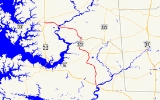
Maryland Route 331
Encyclopedia
Maryland Route 331 is a 28.74 miles (46.25 km) state highway
on the Eastern Shore of Maryland
in the United States
. The route runs from Vienna
in Dorchester County
northwest to Easton
in Talbot County
, intersecting U.S. Route 50
at both ends. MD 331 is a two-lane undivided road most of its length that passes mostly through agricultural areas. The road also passes through the communities of Hurlock
and Preston
along the way. It encounters several routes during its journey, including Maryland Route 14
near Rhodesdale
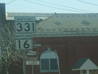
and Maryland Route 16
in the Preston area, both of which the route forms concurrencies
with. In addition, the route also intersects with Maryland Route 392
and Maryland Route 307
in Hurlock and with Maryland Route 318
near Preston.
Most of present-day MD 331 was designated as part of U.S. Route 213 in 1926 when the U.S. Highway System was established. By 1940, US 213 was moved to a new alignment that crossed the Choptank River
at Cambridge
on a bridge built in 1935 and MD 331 was designated to run from Vienna to Easton. Both ends of MD 331 have been shortened since, with the southernmost portion of MD 331 curtailed following the completion of the US 50 bypass of Vienna by the 1990s and the northern terminus of the route cut back to US 50 in 2004 when the state-maintained portion of Dover Road to Dover Street in Easton was turned over to the city.
 Maryland Route 331 begins at an interchange with U.S. Route 50
in Vienna
, Dorchester County
, a short distance west of the Nanticoke River
. From this interchange, the route heads north on Rhodesdale Vienna Road, a two-lane undivided road with a 50 mph (80.5 km/h) speed limit. It passes through wooded areas, with a set of power line
s and an abandoned railroad line located along the east side of the road. MD 331 continues into farmland, with some rural residences alongside the road, before it approaches Reids Grove, where Maryland Route 819 (Reids Grove Road) loops to the west of MD 331. Past Reids Grove, the route continues through a mix of woodland and farmland, still paralleling the power lines and the abandoned railroad. MD 331 reaches Rhodesdale
, where it intersects Maryland Route 14
(Rhodesdale Eldorado Road). At this intersection, the route makes a left turn to run concurrent
with MD 14 along East New Market Rhodesdale Road, heading west through Rhodesdale as a 30 mph (48.3 km/h) road. The road leaves Rhodesdale and heads into farmland as a 50 mph (80.5 km/h) road again. MD 331 splits from MD 14 by turning north on Shiloh Church Hurlock Road at an intersection. Along Shiloh Church Hurlock Road, MD 331 passes a few residences before heading through more farm fields.
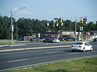
Before the road enters Hurlock
, the speed limit decreases to 40 mph (64.4 km/h). In Hurlock, MD 331 heads into residential areas and the speed limit drops further to 30 mph (48.3 km/h) before the road crosses Jackson Street, where it becomes Main Street. It passes more residences before intersecting Maryland Route 392
(Delaware Avenue). Past MD 392, the speed limit lowers to 25 mph (40.2 km/h) as the road passes more homes before it heads into the downtown area of Hurlock, where it crosses a Maryland and Delaware Railroad
line and Maryland Route 307
(Broad Street). Past this intersection, MD 331 heads northwest on Academy Street past numerous homes as the speed limit increases to 30 mph (48.3 km/h) and then to 40 mph (64.4 km/h) as the road leaves Hurlock. Upon leaving Hurlock, the road becomes Waddells Corner Road and the speed limit climbs to 50 mph (80.5 km/h) again as it heads into farmland. The road turns to the west and continues through agricultural areas with intermittent residences. It comes to an intersection with Maryland Route 16
(East New Market Ellwood Road), where MD 331 makes a right turn to head north along with MD 16. MD 16 and MD 331 head north through a mix of woods and farms with some residences. The road continues through rural areas with an increasing number of residences as it approaches the Preston
area. The road intersects the western terminus of Maryland Route 318
(Preston Road) near a car dealership. Past this intersection, MD 16 and MD 331 continue northwest on Preston Road.
 The road crosses the Hunting Creek into Caroline County
. Before entering Preston, Maryland Route 817 loops off to the west of MD 16 and MD 331 on Linchester Road. Past MD 817, the road enters Preston, where it becomes Main Street, passing by residences and some businesses as a 25 mph (40.2 km/h) road. The route intersects Maryland Route 324 (Maple Avenue) before reaching the center of town, where MD 16 splits from MD 331 by heading northeast on Harmony Road. Past this intersection, the route passes more residences before leaving Preston, where it becomes 50 mph (80.5 km/h) Dover Bridge Road. It heads north into rural areas of woods and farms with some residences along the road. The road turns to the northwest and intersects Tanyard Road. MD 331 turns west and continues to the residential community of Bethlehem
, where the speed limit decreases to 30 mph (48.3 km/h) and it intersects Maryland Route 578
(Bethlehem Road). Past Bethlehem, the road becomes a 50 mph (80.5 km/h) road again and continues past many rural residences.
MD 331 enters wetlands as it approaches the Choptank River
, which it crosses into Talbot County
on the Dover Bridge, a swing bridge
. Upon entering Talbot County, the route becomes Dover Road and continues to the northwest through a mix of woodland and farmland. It turns to the west with the number of residences increasing as it approaches Easton
. Upon reaching Easton, the speed limit decreases to 40 mph (64.4 km/h) and then to 30 mph (48.3 km/h) as MD 331 heads into commercial and industrial areas. The route ends at the intersection with US 50 (Ocean Gateway), where Dover Road continues west as a local road toward downtown Easton.
The first section of the Vienna–Rhodesdale highway was 2 miles (3.2 km) of pavement south from Rhodesdale that was completed by 1923. The remainder of the highway was under construction by 1924, with another 2 miles (3.2 km) section of the road completed north from Vienna by 1927. The gap between Vienna and Rhodesdale was filled in 1928. When the Nanticoke River Bridge at Vienna was completed in 1931, US 213 was rerouted between Mardela Springs and Rhodesdale to pass through Vienna. A new Dover Bridge, replacing a bridge built in the 19th century, was completed in 1932. In 1939, the original MD 331 and US 213 swapped routes; US 213 also assumed MD 344 between Vienna and MD 16 at Mount Holly.
MD 331 has seen little change since 1939. MD 331 and MD 16 were realigned around Ellwood and Linchester around 1960. MD 331's southern terminus was truncated at its newly constructed interchange with US 50 in Vienna in 1991 shortly after US 50 bypassed Vienna. MD 331's northern terminus has been rolled back twice in Easton. The state highway was rolled back from Washington Street to Park Street in 1983. MD 331 was truncated at US 50 in 2004.
State highway
State highway, state road or state route can refer to one of three related concepts, two of them related to a state or provincial government in a country that is divided into states or provinces :#A...
on the Eastern Shore of Maryland
Maryland
Maryland is a U.S. state located in the Mid Atlantic region of the United States, bordering Virginia, West Virginia, and the District of Columbia to its south and west; Pennsylvania to its north; and Delaware to its east...
in the United States
United States
The United States of America is a federal constitutional republic comprising fifty states and a federal district...
. The route runs from Vienna
Vienna, Maryland
Vienna is a town in Dorchester County, Maryland, United States. The population was 280 at the 2000 census.-History:Vienna was founded in 1706. It thrived on trade, shipbuilding and tobacco farming. Throughout the next century, the British would raid the town repeatedly, and also during the War of...
in Dorchester County
Dorchester County, Maryland
Dorchester County is a county located in the U.S. state of Maryland on its Eastern Shore. It is bordered by the Choptank River to the north, Talbot County to the northwest, Caroline County to the northeast, Wicomico County to the southeast, Sussex County, Delaware, to the east, and the Chesapeake...
northwest to Easton
Easton, Maryland
Easton, founded 1710, is a town within the Easton District of Talbot County, Maryland, United States. The population was 11,708 at the 2000 census, and 14,677 according to current July 2008 census estimates. It is the county seat of Talbot County. The primary ZIP Code is 21601, and the...
in Talbot County
Talbot County, Maryland
-2010:Whereas according to the 2010 U.S. Census Bureau:*81.4% White*12.8% Black*0.2% Native American*1.2% Asian*0.1% Native Hawaiian or Pacific Islander*1.6% Two or more races*2.7% Other races*5.5% Hispanic or Latino -2000:...
, intersecting U.S. Route 50
U.S. Route 50 in Maryland
U.S. Route 50 is a major east–west route of the U.S. Highway system, stretching just over from Ocean City, Maryland on the Atlantic Ocean to West Sacramento, California. In the U.S. state of Maryland, US 50 exists in two sections. The longer of these serves as a major route connecting...
at both ends. MD 331 is a two-lane undivided road most of its length that passes mostly through agricultural areas. The road also passes through the communities of Hurlock
Hurlock, Maryland
Hurlock is a town in Dorchester County, Maryland, United States. The population was 1,874 at the 2000 census. It is home to WAAI radio. Joyce Spratt is the current mayor, and the town has five council members—Michael E. Henry , Michael D. Nordstrom , Parker J. Durham , Charles T. Cephas and...
and Preston
Preston, Maryland
Preston is a town in Caroline County, Maryland, United States. The population was 566 at the 2000 census. The ZIP code is 21655. The primary phone exchange is 673 and the area code is 410....
along the way. It encounters several routes during its journey, including Maryland Route 14
Maryland Route 14
Maryland Route 14 is a state highway in the U.S. state of Maryland. The state highway runs from MD 16 in Secretary east to MD 313 in Eldorado. MD 14 connects those two towns with the towns of East New Market and Brookview in northern Dorchester County. The state highway also shares a...
near Rhodesdale
Rhodesdale, Maryland
Rhodesdale is an unincorporated community in Dorchester County, Maryland, United States.-References:...
and Maryland Route 16
Maryland Route 16
Maryland Route 16 is a state highway in the U.S. state of Maryland. The state highway runs from Taylors Island east to the Delaware state line in Hickman, where the highway continues as Delaware Route 16...
in the Preston area, both of which the route forms concurrencies
Concurrency (road)
A concurrency, overlap, or coincidence in a road network is an instance of one physical road bearing two or more different highway, motorway, or other route numbers...
with. In addition, the route also intersects with Maryland Route 392
Maryland Route 392
Maryland Route 392 is a state highway in the U.S. state of Maryland. The state highway runs from MD 16 in East New Market east to the Delaware state line in Reliance, where the highway continues east as Delaware Route 20 . MD 392 connects East New Market with Hurlock as well as Seaford,...
and Maryland Route 307
Maryland Route 307
Maryland Route 307 is a state highway in the U.S. state of Maryland. Known for most of its length as Williamsburg Road, the state highway runs from MD 331 in Hurlock north to the end of state maintenance a short distance east of the intersection with MD 313 and MD 318 in Federalsburg...
in Hurlock and with Maryland Route 318
Maryland Route 318
Maryland Route 318 is a state highway in the U.S. state of Maryland. The state highway runs from MD 16 and MD 331 near Preston east to the Delaware state line near Federalsburg, where the highway continues east as Delaware Route 18 . MD 318 follows the Dorchester–Caroline county line for...
near Preston.
Most of present-day MD 331 was designated as part of U.S. Route 213 in 1926 when the U.S. Highway System was established. By 1940, US 213 was moved to a new alignment that crossed the Choptank River
Choptank River
The Choptank River is a major tributary of the Chesapeake Bay on the Delmarva Peninsula. Running for , it rises in Kent County, Delaware, runs through Caroline County, Maryland and forms much of the border between Talbot County, Maryland on the north, and Caroline County and Dorchester County on...
at Cambridge
Cambridge, Maryland
Cambridge is a city in Dorchester County, Maryland, United States. The population was 12,326 at the 2010 census. It is the county seat of Dorchester County and the county's largest municipality...
on a bridge built in 1935 and MD 331 was designated to run from Vienna to Easton. Both ends of MD 331 have been shortened since, with the southernmost portion of MD 331 curtailed following the completion of the US 50 bypass of Vienna by the 1990s and the northern terminus of the route cut back to US 50 in 2004 when the state-maintained portion of Dover Road to Dover Street in Easton was turned over to the city.
Dorchester County
U.S. Route 50 in Maryland
U.S. Route 50 is a major east–west route of the U.S. Highway system, stretching just over from Ocean City, Maryland on the Atlantic Ocean to West Sacramento, California. In the U.S. state of Maryland, US 50 exists in two sections. The longer of these serves as a major route connecting...
in Vienna
Vienna, Maryland
Vienna is a town in Dorchester County, Maryland, United States. The population was 280 at the 2000 census.-History:Vienna was founded in 1706. It thrived on trade, shipbuilding and tobacco farming. Throughout the next century, the British would raid the town repeatedly, and also during the War of...
, Dorchester County
Dorchester County, Maryland
Dorchester County is a county located in the U.S. state of Maryland on its Eastern Shore. It is bordered by the Choptank River to the north, Talbot County to the northwest, Caroline County to the northeast, Wicomico County to the southeast, Sussex County, Delaware, to the east, and the Chesapeake...
, a short distance west of the Nanticoke River
Nanticoke River
The Nanticoke River is a major tributary of the Chesapeake Bay on the Delmarva Peninsula. It rises in southern Kent County, Delaware, flows through Sussex County, Delaware, and forms the boundary between Dorchester County, Maryland and Wicomico County, Maryland. The river course proceeds southwest...
. From this interchange, the route heads north on Rhodesdale Vienna Road, a two-lane undivided road with a 50 mph (80.5 km/h) speed limit. It passes through wooded areas, with a set of power line
Power Line
Power Line is an American political blog, providing news and commentary from a conservative point-of-view. It was originally written by three lawyers who attended Dartmouth College together: John H. Hinderaker, Scott W. Johnson, and Paul Mirengoff...
s and an abandoned railroad line located along the east side of the road. MD 331 continues into farmland, with some rural residences alongside the road, before it approaches Reids Grove, where Maryland Route 819 (Reids Grove Road) loops to the west of MD 331. Past Reids Grove, the route continues through a mix of woodland and farmland, still paralleling the power lines and the abandoned railroad. MD 331 reaches Rhodesdale
Rhodesdale, Maryland
Rhodesdale is an unincorporated community in Dorchester County, Maryland, United States.-References:...
, where it intersects Maryland Route 14
Maryland Route 14
Maryland Route 14 is a state highway in the U.S. state of Maryland. The state highway runs from MD 16 in Secretary east to MD 313 in Eldorado. MD 14 connects those two towns with the towns of East New Market and Brookview in northern Dorchester County. The state highway also shares a...
(Rhodesdale Eldorado Road). At this intersection, the route makes a left turn to run concurrent
Concurrency (road)
A concurrency, overlap, or coincidence in a road network is an instance of one physical road bearing two or more different highway, motorway, or other route numbers...
with MD 14 along East New Market Rhodesdale Road, heading west through Rhodesdale as a 30 mph (48.3 km/h) road. The road leaves Rhodesdale and heads into farmland as a 50 mph (80.5 km/h) road again. MD 331 splits from MD 14 by turning north on Shiloh Church Hurlock Road at an intersection. Along Shiloh Church Hurlock Road, MD 331 passes a few residences before heading through more farm fields.
Before the road enters Hurlock
Hurlock, Maryland
Hurlock is a town in Dorchester County, Maryland, United States. The population was 1,874 at the 2000 census. It is home to WAAI radio. Joyce Spratt is the current mayor, and the town has five council members—Michael E. Henry , Michael D. Nordstrom , Parker J. Durham , Charles T. Cephas and...
, the speed limit decreases to 40 mph (64.4 km/h). In Hurlock, MD 331 heads into residential areas and the speed limit drops further to 30 mph (48.3 km/h) before the road crosses Jackson Street, where it becomes Main Street. It passes more residences before intersecting Maryland Route 392
Maryland Route 392
Maryland Route 392 is a state highway in the U.S. state of Maryland. The state highway runs from MD 16 in East New Market east to the Delaware state line in Reliance, where the highway continues east as Delaware Route 20 . MD 392 connects East New Market with Hurlock as well as Seaford,...
(Delaware Avenue). Past MD 392, the speed limit lowers to 25 mph (40.2 km/h) as the road passes more homes before it heads into the downtown area of Hurlock, where it crosses a Maryland and Delaware Railroad
Maryland and Delaware Railroad
The Maryland and Delaware Railroad Company is a Class III short-line railroad, formed in 1977 to operate several branch lines of the former Penn Central Railroad in both Maryland and Delaware. These branches were omitted from the system plan for Conrail in 1976 and would have been discontinued...
line and Maryland Route 307
Maryland Route 307
Maryland Route 307 is a state highway in the U.S. state of Maryland. Known for most of its length as Williamsburg Road, the state highway runs from MD 331 in Hurlock north to the end of state maintenance a short distance east of the intersection with MD 313 and MD 318 in Federalsburg...
(Broad Street). Past this intersection, MD 331 heads northwest on Academy Street past numerous homes as the speed limit increases to 30 mph (48.3 km/h) and then to 40 mph (64.4 km/h) as the road leaves Hurlock. Upon leaving Hurlock, the road becomes Waddells Corner Road and the speed limit climbs to 50 mph (80.5 km/h) again as it heads into farmland. The road turns to the west and continues through agricultural areas with intermittent residences. It comes to an intersection with Maryland Route 16
Maryland Route 16
Maryland Route 16 is a state highway in the U.S. state of Maryland. The state highway runs from Taylors Island east to the Delaware state line in Hickman, where the highway continues as Delaware Route 16...
(East New Market Ellwood Road), where MD 331 makes a right turn to head north along with MD 16. MD 16 and MD 331 head north through a mix of woods and farms with some residences. The road continues through rural areas with an increasing number of residences as it approaches the Preston
Preston, Maryland
Preston is a town in Caroline County, Maryland, United States. The population was 566 at the 2000 census. The ZIP code is 21655. The primary phone exchange is 673 and the area code is 410....
area. The road intersects the western terminus of Maryland Route 318
Maryland Route 318
Maryland Route 318 is a state highway in the U.S. state of Maryland. The state highway runs from MD 16 and MD 331 near Preston east to the Delaware state line near Federalsburg, where the highway continues east as Delaware Route 18 . MD 318 follows the Dorchester–Caroline county line for...
(Preston Road) near a car dealership. Past this intersection, MD 16 and MD 331 continue northwest on Preston Road.
Caroline and Talbot counties
Caroline County, Maryland
Caroline County is a wholly rural county located in the U.S. state of Maryland on its Eastern Shore. It is bordered by Queen Anne's County to the north, Talbot County to the west, Dorchester County to the south, Kent County, Delaware, to the east, and Sussex County, Delaware, to the southeast. As...
. Before entering Preston, Maryland Route 817 loops off to the west of MD 16 and MD 331 on Linchester Road. Past MD 817, the road enters Preston, where it becomes Main Street, passing by residences and some businesses as a 25 mph (40.2 km/h) road. The route intersects Maryland Route 324 (Maple Avenue) before reaching the center of town, where MD 16 splits from MD 331 by heading northeast on Harmony Road. Past this intersection, the route passes more residences before leaving Preston, where it becomes 50 mph (80.5 km/h) Dover Bridge Road. It heads north into rural areas of woods and farms with some residences along the road. The road turns to the northwest and intersects Tanyard Road. MD 331 turns west and continues to the residential community of Bethlehem
Bethlehem, Maryland
Bethlehem is an unincorporated community in Caroline County, Maryland, United States.-References:...
, where the speed limit decreases to 30 mph (48.3 km/h) and it intersects Maryland Route 578
Maryland Route 578
Maryland Route 578 is a state highway in the U.S. state of Maryland. Known as Bethlehem Road, the state highway runs from MD 331 in Bethlehem east to MD 16 in Harmony. The first segment of MD 578 was completed in the mid 1930s; the remainder was built in the early 1940s.-Route description:MD...
(Bethlehem Road). Past Bethlehem, the road becomes a 50 mph (80.5 km/h) road again and continues past many rural residences.
MD 331 enters wetlands as it approaches the Choptank River
Choptank River
The Choptank River is a major tributary of the Chesapeake Bay on the Delmarva Peninsula. Running for , it rises in Kent County, Delaware, runs through Caroline County, Maryland and forms much of the border between Talbot County, Maryland on the north, and Caroline County and Dorchester County on...
, which it crosses into Talbot County
Talbot County, Maryland
-2010:Whereas according to the 2010 U.S. Census Bureau:*81.4% White*12.8% Black*0.2% Native American*1.2% Asian*0.1% Native Hawaiian or Pacific Islander*1.6% Two or more races*2.7% Other races*5.5% Hispanic or Latino -2000:...
on the Dover Bridge, a swing bridge
Swing bridge
A swing bridge is a movable bridge that has as its primary structural support a vertical locating pin and support ring, usually at or near to its centre of gravity, about which the turning span can then pivot horizontally as shown in the animated illustration to the right...
. Upon entering Talbot County, the route becomes Dover Road and continues to the northwest through a mix of woodland and farmland. It turns to the west with the number of residences increasing as it approaches Easton
Easton, Maryland
Easton, founded 1710, is a town within the Easton District of Talbot County, Maryland, United States. The population was 11,708 at the 2000 census, and 14,677 according to current July 2008 census estimates. It is the county seat of Talbot County. The primary ZIP Code is 21601, and the...
. Upon reaching Easton, the speed limit decreases to 40 mph (64.4 km/h) and then to 30 mph (48.3 km/h) as MD 331 heads into commercial and industrial areas. The route ends at the intersection with US 50 (Ocean Gateway), where Dover Road continues west as a local road toward downtown Easton.
Original MD 331
MD 331 was originally assigned to the Easton–Trappe Road in southern Talbot County, one of the original state roads designated for improvement by the Maryland State Roads Commission in 1909. The Easton–Trappe Road followed present-day MD 565 north from Trappe. At Peach Blossom Creek, the old highway is overlaid by US 50 and MD 322. The old alignment of MD 331 reappears as Washington Street in Easton, ending at Dover Street, where the main highway of the Eastern Shore that would later be designated US 213 turned north onto Washington Street. MD 331 was paved from Easton in 1915 and reached Trappe by 1919. The state highway was extended south to Cambridge when the first Choptank River Bridge opened in December 1935. On the Cambridge side of the bridge, a dual highway was constructed south to MD 16.Present MD 331
MD 331 from Rhodesdale to Easton was one of the original state roads marked for improvement in 1909. In 1910, the only paved sections of the highway were the approaches to Dover Bridge in both Talbot County and Caroline County. The state road was paved from Hurlock to Shiloh Church in 1912, from Easton to Waddell's Corner in 1913 and 1914, from Waddell's Corner to Hurlock in 1915, and within Hurlock in 1916. When the U.S. Highway System was organized in 1926, the state road became part of US 213.The first section of the Vienna–Rhodesdale highway was 2 miles (3.2 km) of pavement south from Rhodesdale that was completed by 1923. The remainder of the highway was under construction by 1924, with another 2 miles (3.2 km) section of the road completed north from Vienna by 1927. The gap between Vienna and Rhodesdale was filled in 1928. When the Nanticoke River Bridge at Vienna was completed in 1931, US 213 was rerouted between Mardela Springs and Rhodesdale to pass through Vienna. A new Dover Bridge, replacing a bridge built in the 19th century, was completed in 1932. In 1939, the original MD 331 and US 213 swapped routes; US 213 also assumed MD 344 between Vienna and MD 16 at Mount Holly.
MD 331 has seen little change since 1939. MD 331 and MD 16 were realigned around Ellwood and Linchester around 1960. MD 331's southern terminus was truncated at its newly constructed interchange with US 50 in Vienna in 1991 shortly after US 50 bypassed Vienna. MD 331's northern terminus has been rolled back twice in Easton. The state highway was rolled back from Washington Street to Park Street in 1983. MD 331 was truncated at US 50 in 2004.
Junction list
| County | Location | Mile |
Roads intersected | Notes | ||
|---|---|---|---|---|---|---|
| Dorchester Dorchester County, Maryland Dorchester County is a county located in the U.S. state of Maryland on its Eastern Shore. It is bordered by the Choptank River to the north, Talbot County to the northwest, Caroline County to the northeast, Wicomico County to the southeast, Sussex County, Delaware, to the east, and the Chesapeake... |
Vienna Vienna, Maryland Vienna is a town in Dorchester County, Maryland, United States. The population was 280 at the 2000 census.-History:Vienna was founded in 1706. It thrived on trade, shipbuilding and tobacco farming. Throughout the next century, the British would raid the town repeatedly, and also during the War of... |
0.00 | Interchange, southern terminus of MD 331 | |||
| Reids Grove | 2.73-2.90 | Loop to west of MD 331 | ||||
| Rhodesdale Rhodesdale, Maryland Rhodesdale is an unincorporated community in Dorchester County, Maryland, United States.-References:... |
5.92 | South end of MD 14 overlap | ||||
| 7.96 | North end of MD 14 overlap | |||||
| Hurlock Hurlock, Maryland Hurlock is a town in Dorchester County, Maryland, United States. The population was 1,874 at the 2000 census. It is home to WAAI radio. Joyce Spratt is the current mayor, and the town has five council members—Michael E. Henry , Michael D. Nordstrom , Parker J. Durham , Charles T. Cephas and... |
10.91 | |||||
| 11.37 | ||||||
| 13.82 | South end of MD 16 overlap | |||||
| 17.14 | ||||||
| Caroline Caroline County, Maryland Caroline County is a wholly rural county located in the U.S. state of Maryland on its Eastern Shore. It is bordered by Queen Anne's County to the north, Talbot County to the west, Dorchester County to the south, Kent County, Delaware, to the east, and Sussex County, Delaware, to the southeast. As... |
Preston Preston, Maryland Preston is a town in Caroline County, Maryland, United States. The population was 566 at the 2000 census. The ZIP code is 21655. The primary phone exchange is 673 and the area code is 410.... |
17.36-17.78 | Loop to west of MD 16/MD 331 | |||
| 18.33 | ||||||
| 18.40 | North end of MD 16 overlap | |||||
| Bethlehem Bethlehem, Maryland Bethlehem is an unincorporated community in Caroline County, Maryland, United States.-References:... |
21.81 | |||||
| 24.78 | Dover Bridge over Choptank River Choptank River The Choptank River is a major tributary of the Chesapeake Bay on the Delmarva Peninsula. Running for , it rises in Kent County, Delaware, runs through Caroline County, Maryland and forms much of the border between Talbot County, Maryland on the north, and Caroline County and Dorchester County on... |
|||||
| Talbot Talbot County, Maryland -2010:Whereas according to the 2010 U.S. Census Bureau:*81.4% White*12.8% Black*0.2% Native American*1.2% Asian*0.1% Native Hawaiian or Pacific Islander*1.6% Two or more races*2.7% Other races*5.5% Hispanic or Latino -2000:... |
Easton Easton, Maryland Easton, founded 1710, is a town within the Easton District of Talbot County, Maryland, United States. The population was 11,708 at the 2000 census, and 14,677 according to current July 2008 census estimates. It is the county seat of Talbot County. The primary ZIP Code is 21601, and the... |
28.74 | Northern terminus of MD 331 | |||