
Maryland Route 544
Encyclopedia
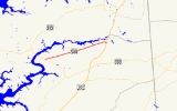
Maryland Route 544 is a state highway
in the U.S. state
of Maryland
. Known as McGinnes Road, the state highway runs 9.48 mi (15.3 km) from MD 213
in Kingstown
east to MD 313
in Unicorn. MD 544, which spans the northern tier of Queen Anne's County
, is officially separated into two sections, MD 544 and MD 544A, separated by a superstreet
intersection with U.S. Route 301
(US 301). MD 544 was constructed in four sections. A short segment east of MD 290
was paved by 1921. The segment east of there to Unicorn was paved in the early 1930s. A segment west of MD 290 to McGinnes Corner was constructed in the late 1930s. The remainder of the highway west to US 213 (now MD 213) was completed in the late 1940s.
. The state highway continues east in a straight line until it reaches the western edge of the hamlet of Unicorn, where the old alignment, Chester River Heights Road, continues straight while MD 544 veers to the southeast. MD 544 officially ends at US 301 (Blue Star Memorial Highway), where the two highways meet at a superstreet intersection. Traffic on MD 544 is required to turn right onto US 301, make a U-turn, and turn right again to continue on MD 544. The roadway, now officially MD 544A, continues 0.19 mi (0.3057746 km) to the highway's eastern terminus at MD 313 (Millington Road).
.
{|class=wikitable
!Location
!Mile
!Destinations
!Notes
|-
|rowspan=1|Kingstown
|0.00
|
|Western terminus of MD 544
|-
|rowspan=1|Crumpton
|6.99
|
|
|-
|rowspan=3|Unicorn
|9.08
|Chester River Heights Road east / Red Lion Branch Road south
|Chester River Heights Road is old alignment of MD 544
|-
|9.29
|, Wilmington
|Superstreet intersection; eastern terminus of MD 544; western terminus of MD 544A
|-
|9.48
|
|Eastern terminus of MD 544
State highway
State highway, state road or state route can refer to one of three related concepts, two of them related to a state or provincial government in a country that is divided into states or provinces :#A...
in the U.S. state
U.S. state
A U.S. state is any one of the 50 federated states of the United States of America that share sovereignty with the federal government. Because of this shared sovereignty, an American is a citizen both of the federal entity and of his or her state of domicile. Four states use the official title of...
of Maryland
Maryland
Maryland is a U.S. state located in the Mid Atlantic region of the United States, bordering Virginia, West Virginia, and the District of Columbia to its south and west; Pennsylvania to its north; and Delaware to its east...
. Known as McGinnes Road, the state highway runs 9.48 mi (15.3 km) from MD 213
Maryland Route 213
Maryland Route 213 is a state highway located on the Eastern Shore of Maryland in the United States. The route runs from Maryland Route 662 in Wye Mills, Queen Anne's County north to the Pennsylvania border in Cecil County, where it continues into that state as Pennsylvania Route 841...
in Kingstown
Kingstown, Maryland
Kingstown is a census-designated place in Queen Anne's County, Maryland, United States. The population was 1,644 at the 2000 census.-Geography:Kingstown is located at ....
east to MD 313
Maryland Route 313
Maryland Route 313 is a state highway located on the Eastern Shore of Maryland in the United States. The route runs from U.S. Route 50 in Mardela Springs, Wicomico County north to Maryland Route 213 and Maryland Route 290 in Galena, Kent County...
in Unicorn. MD 544, which spans the northern tier of Queen Anne's County
Queen Anne's County, Maryland
Queen Anne's County is a county located on the Eastern Shore of the U.S. state of Maryland.As of 2010, the population was 47,798. Its county seat and most populous municipality is Centreville. The census-designated place of Stevensville is the county's most populous place...
, is officially separated into two sections, MD 544 and MD 544A, separated by a superstreet
Superstreet
A superstreet is a type of road intersection that is a variation of the Michigan left. In this configuration, traffic on the minor road is not permitted to proceed straight across the major road or highway; traffic wishing to turn left or go straight must turn right onto the major road, make a...
intersection with U.S. Route 301
U.S. Route 301 in Maryland
U.S. Route 301 in Maryland is a major highway that runs from Delaware to the Governor Harry W. Nice Memorial Bridge into Virginia. It passes through three of Maryland's four main regions: the Eastern Shore, the Baltimore-Washington Metropolitan Area, and Southern Maryland...
(US 301). MD 544 was constructed in four sections. A short segment east of MD 290
Maryland Route 290
Maryland Route 290 is a state highway in the U.S. state of Maryland. The state highway runs from MD 300 at Dudley Corners north to MD 299 in Sassafras. MD 290 roughly parallels U.S. Route 301 , which it intersects twice, as it connects the communities of Crumpton in northern Queen Anne's County...
was paved by 1921. The segment east of there to Unicorn was paved in the early 1930s. A segment west of MD 290 to McGinnes Corner was constructed in the late 1930s. The remainder of the highway west to US 213 (now MD 213) was completed in the late 1940s.
Route description
MD 544 begins at an intersection with MD 213 (Church Hill Road) in Kingstown. The state highway heads east-northeast in a nearly straight alignment through farmland. MD 544 crosses Foreman Branch and Pearl Creek, passing through the hamlet of McGinnes Corner between the streams, before intersecting MD 290 (Dudley Corner Road) just south of CrumptonCrumpton, Maryland
Crumpton is an unincorporated community in Queen Anne's County, Maryland, United States. Crumpton is located along the Chester River west-southwest of Millington. Crumpton has a post office with ZIP code 21628....
. The state highway continues east in a straight line until it reaches the western edge of the hamlet of Unicorn, where the old alignment, Chester River Heights Road, continues straight while MD 544 veers to the southeast. MD 544 officially ends at US 301 (Blue Star Memorial Highway), where the two highways meet at a superstreet intersection. Traffic on MD 544 is required to turn right onto US 301, make a U-turn, and turn right again to continue on MD 544. The roadway, now officially MD 544A, continues 0.19 mi (0.3057746 km) to the highway's eastern terminus at MD 313 (Millington Road).
History
The first section of present day MD 544 paved was as a state aid road from present day MD 290 east to Perry Lynch Road by 1921. The first section of highway designated MD 544 was paved from MD 313 to Perry Lynch Road in 1933. Another section of MD 544 was built from MD 290 west to McGinnes Corner in two sections completed in 1936 and 1938. A road west to US 213 (now MD 213) was paved by 1946, but the MD 545 designation was not applied to that road, as well as the original state aid section, until 1948. The state highway once continued its straight alignment to its eastern terminus, but in 1967 the highway's terminus at MD 313 was relocated to allow a perpendicular intersection with US 301, which was being expanded to a divided highway at that time. The old alignment of MD 544 comprises Chester River Heights Road west of US 301 and Legion Road to the east. The MD 544–US 301 junction was transformed into a superstreet intersection in 2006, resulting in the designation of MD 544A east of the junction.Junction list
The entire route is in Queen Anne's CountyQueen Anne's County, Maryland
Queen Anne's County is a county located on the Eastern Shore of the U.S. state of Maryland.As of 2010, the population was 47,798. Its county seat and most populous municipality is Centreville. The census-designated place of Stevensville is the county's most populous place...
.
{|class=wikitable
!Location
!Mile
!Destinations
!Notes
|-
|rowspan=1|Kingstown
Kingstown, Maryland
Kingstown is a census-designated place in Queen Anne's County, Maryland, United States. The population was 1,644 at the 2000 census.-Geography:Kingstown is located at ....
|0.00
|
|Western terminus of MD 544
|-
|rowspan=1|Crumpton
Crumpton, Maryland
Crumpton is an unincorporated community in Queen Anne's County, Maryland, United States. Crumpton is located along the Chester River west-southwest of Millington. Crumpton has a post office with ZIP code 21628....
|6.99
|
|
|-
|rowspan=3|Unicorn
|9.08
|Chester River Heights Road east / Red Lion Branch Road south
|Chester River Heights Road is old alignment of MD 544
|-
|9.29
|, Wilmington
Wilmington, Delaware
Wilmington is the largest city in the state of Delaware, United States, and is located at the confluence of the Christina River and Brandywine Creek, near where the Christina flows into the Delaware River. It is the county seat of New Castle County and one of the major cities in the Delaware Valley...
|Superstreet intersection; eastern terminus of MD 544; western terminus of MD 544A
|-
|9.48
|
|Eastern terminus of MD 544