
Maryland Route 285
Encyclopedia
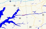
Maryland Route 285 is a state highway
in the U.S. state
of Maryland
. The state highway runs 2.43 miles (3.9 km) from MD 213
east to the Delaware
state line within Chesapeake City
. MD 285 roughly parallels the north side of the Chesapeake and Delaware Canal
in southern Cecil County
. The state highway was paved along Biddle Street from Lock Street, then part of U.S. Route 213 (now MD 213), east to the state line around 1930. When US 213 was moved to the Chesapeake City Bridge
in the late 1940s, MD 285 was extended along Lock Street to reconnect with US 213.
(Hemphill Street), MD 285 curves to the southwest, following Lock Street into the town of Chesapeake City to its intersection with Biddle Street. MD 285 turns east onto Biddle Street while a stub of Lock Street continues south to the edge of the canal as unsigned MD 537B
. The state highway passes through a residential section of the north side of the town, meeting the other end of MD 284. MD 285 runs through an S-curve before leaving the town limits. The state highway passes through a mix of farmland and scattered residences as it parallels the north side of the canal. At Knights Corner Road, MD 285 curves to the northeast to its eastern terminus at the Delaware state line. The roadway continues east as Chesapeake City Road.
–Elkton
highway passing through Chesapeake City that was designated for improvement by the Maryland State Roads Commission
in 1909. This segment of state road was paved in 1914. Following the expansion and straightening of the Chesapeake and Delaware Canal in the 1920s, the portion of Lock Street from the northern junction with MD 284 to Biddle Street was constructed as the approach to a vertical lift bridge constructed by the U.S. Army Corps of Engineers, connecting Lock Street on the north side with George Street on the south side of the town in 1926. This new alignment became part of US 213 when the federal highway was marked through southern Cecil County around 1927.
Biddle Street was paved from US 213 to the Delaware state line and designated MD 285 around 1930. The vertical lift bridge used by US 213 to cross the canal was destroyed by the tanker Franz Klasen on July 28, 1942. A ferry was established to carry traffic across the canal until the completion of a new bridge. The Chesapeake City Bridge was completed in 1948 along with new approach roads; US 213 was moved to the new bridge and approach roads and MD 285 was extended north on Lock Street to its present western terminus at US 213.
in Cecil County
.
{| class=wikitable
!Mile
!Destinations
!Notes
|-
|0.00
|
|Western terminus
|-
|0.29
|
|
|-
|0.57
|Biddle Street west / Lock Street south
|MD 285 turns east onto Biddle Street; Lock Street is unsigned MD 537B
|-
|0.76
|
|
|-
|2.43
|Chesapeake City Road east
|Eastern terminus; Delaware
state line
State highway
State highway, state road or state route can refer to one of three related concepts, two of them related to a state or provincial government in a country that is divided into states or provinces :#A...
in the U.S. state
U.S. state
A U.S. state is any one of the 50 federated states of the United States of America that share sovereignty with the federal government. Because of this shared sovereignty, an American is a citizen both of the federal entity and of his or her state of domicile. Four states use the official title of...
of Maryland
Maryland
Maryland is a U.S. state located in the Mid Atlantic region of the United States, bordering Virginia, West Virginia, and the District of Columbia to its south and west; Pennsylvania to its north; and Delaware to its east...
. The state highway runs 2.43 miles (3.9 km) from MD 213
Maryland Route 213
Maryland Route 213 is a state highway located on the Eastern Shore of Maryland in the United States. The route runs from Maryland Route 662 in Wye Mills, Queen Anne's County north to the Pennsylvania border in Cecil County, where it continues into that state as Pennsylvania Route 841...
east to the Delaware
Delaware
Delaware is a U.S. state located on the Atlantic Coast in the Mid-Atlantic region of the United States. It is bordered to the south and west by Maryland, and to the north by Pennsylvania...
state line within Chesapeake City
Chesapeake City, Maryland
Chesapeake City is a town in Cecil County, Maryland, United States. The population was 787 at the 2000 census.The town was originally named by Bohemian colonist Augustine Herman the Village of Bohemia , but the name was changed in 1839 when the Chesapeake and Delaware Canal was built...
. MD 285 roughly parallels the north side of the Chesapeake and Delaware Canal
Chesapeake and Delaware Canal
The Chesapeake and Delaware Canal is a 14-mile long, 450-foot wide and 40-foot deep ship canal that cuts across the states of Maryland and Delaware, in the United States. It connects the waters of the Delaware River with those of the Chesapeake Bay and the Port of Baltimore...
in southern Cecil County
Cecil County, Maryland
Cecil County is a county located in the U.S. state of Maryland. It is part of the Delaware Valley. It was named for Cæcilius Calvert, 2nd Baron Baltimore , who was the first Proprietary Governor of the colony of Maryland from 1632 until his death in 1675. The county seat is Elkton. The newspaper...
. The state highway was paved along Biddle Street from Lock Street, then part of U.S. Route 213 (now MD 213), east to the state line around 1930. When US 213 was moved to the Chesapeake City Bridge
Chesapeake City Bridge
The Chesapeake City Bridge carries Maryland Route 213 across the Chesapeake & Delaware Canal in Chesapeake City, Maryland. There are two undivided traffic lanes and one sidewalk on the east side of the bridge. It was built in 1949 by the U.S. Army Corps of Engineers to provide a high-level canal...
in the late 1940s, MD 285 was extended along Lock Street to reconnect with US 213.
Route description
MD 285 begins at an intersection with MD 213 (Augustine Herman Highway) just north of the Chesapeake City Bridge. The state highway, which heads east as two-lane Lock Street, curves to the south at the intersection with county-maintained Hemphill Street. At the intersection with MD 284Maryland Route 284
Maryland Route 284 is a state highway in the U.S. state of Maryland. Known as Hemphill Street, the state highway runs between two intersections with MD 285 in Chesapeake City in southern Cecil County. MD 284 was paved in the mid 1910s as part of the original state road between Cecilton and...
(Hemphill Street), MD 285 curves to the southwest, following Lock Street into the town of Chesapeake City to its intersection with Biddle Street. MD 285 turns east onto Biddle Street while a stub of Lock Street continues south to the edge of the canal as unsigned MD 537B
Maryland Route 537
Maryland Route 537 is an unsigned state highway in Cecil County, Maryland running through Chesapeake City. The highway is divided into three segments, all of which are designated with a lettered suffix...
. The state highway passes through a residential section of the north side of the town, meeting the other end of MD 284. MD 285 runs through an S-curve before leaving the town limits. The state highway passes through a mix of farmland and scattered residences as it parallels the north side of the canal. At Knights Corner Road, MD 285 curves to the northeast to its eastern terminus at the Delaware state line. The roadway continues east as Chesapeake City Road.
History
MD 285 was constructed in three sections. The portion of Lock Street between county-maintained Hemphill Street and the northern junction with MD 284 was part of the original CeciltonCecilton, Maryland
Cecilton is a town in Cecil County, Maryland, United States. The population was 474 at the 2000 census.-Geography:Cecilton is located at .According to the United States Census Bureau, the town has a total area of , all of it land....
–Elkton
Elkton, Maryland
The town of Elkton is the county seat of Cecil County, Maryland, United States. The population was 11,893 as of the 2000 census and 14,842 according to current July 2008 census estimates. It is the county seat of Cecil County...
highway passing through Chesapeake City that was designated for improvement by the Maryland State Roads Commission
Maryland State Highway Administration
The Maryland State Highway Administration is the state agency responsible for maintaining Maryland numbered highways outside of Baltimore City...
in 1909. This segment of state road was paved in 1914. Following the expansion and straightening of the Chesapeake and Delaware Canal in the 1920s, the portion of Lock Street from the northern junction with MD 284 to Biddle Street was constructed as the approach to a vertical lift bridge constructed by the U.S. Army Corps of Engineers, connecting Lock Street on the north side with George Street on the south side of the town in 1926. This new alignment became part of US 213 when the federal highway was marked through southern Cecil County around 1927.
Biddle Street was paved from US 213 to the Delaware state line and designated MD 285 around 1930. The vertical lift bridge used by US 213 to cross the canal was destroyed by the tanker Franz Klasen on July 28, 1942. A ferry was established to carry traffic across the canal until the completion of a new bridge. The Chesapeake City Bridge was completed in 1948 along with new approach roads; US 213 was moved to the new bridge and approach roads and MD 285 was extended north on Lock Street to its present western terminus at US 213.
Junction list
The entire route is in Chesapeake CityChesapeake City, Maryland
Chesapeake City is a town in Cecil County, Maryland, United States. The population was 787 at the 2000 census.The town was originally named by Bohemian colonist Augustine Herman the Village of Bohemia , but the name was changed in 1839 when the Chesapeake and Delaware Canal was built...
in Cecil County
Cecil County, Maryland
Cecil County is a county located in the U.S. state of Maryland. It is part of the Delaware Valley. It was named for Cæcilius Calvert, 2nd Baron Baltimore , who was the first Proprietary Governor of the colony of Maryland from 1632 until his death in 1675. The county seat is Elkton. The newspaper...
.
{| class=wikitable
!Mile
!Destinations
!Notes
|-
|0.00
|
|Western terminus
|-
|0.29
|
|
|-
|0.57
|Biddle Street west / Lock Street south
|MD 285 turns east onto Biddle Street; Lock Street is unsigned MD 537B
Maryland Route 537
Maryland Route 537 is an unsigned state highway in Cecil County, Maryland running through Chesapeake City. The highway is divided into three segments, all of which are designated with a lettered suffix...
|-
|0.76
|
|
|-
|2.43
|Chesapeake City Road east
|Eastern terminus; Delaware
Delaware
Delaware is a U.S. state located on the Atlantic Coast in the Mid-Atlantic region of the United States. It is bordered to the south and west by Maryland, and to the north by Pennsylvania...
state line