
Maryland Route 286
Encyclopedia
Maryland Route 286 is a state highway
in the U.S. state
of Maryland
. Known for most of its length as Bethel Road, the state highway runs 2.09 miles (3.4 km) from George Street, which is one of the segments of unsigned
Maryland Route 537
, east within Chesapeake City
to the Delaware
state line, where the highway continues east as Delaware Route 286
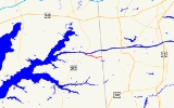
(DE 286). MD 286 roughly parallels the south side of the Chesapeake and Delaware Canal
in southern Cecil County
. MD 286 was constructed around 1930. The state highway originally served the lost community of Bethel near the state line, but was rerouted to the Delaware state line in the early 1960s due to expansion of the canal.
 MD 286 begins at an intersection with George Street (unsigned MD 537C) on the south side of Chesapeake City. The state highway heads east as two-lane 2nd Street through the South Chesapeake City Historic District
. At Bohemia Avenue, MD 286 becomes Bethel Road and curves around the Back Creek Mooring Basin. After crossing Back Creek, the state highway makes a right-angle turn at the entrance to the Chesapeake and Delaware Canal Museum. MD 286 leaves the town limits of Chesapeake City and passes through a forested area along the south boundary of the Canal Wildlife Management Area. Shortly after the intersection with Bethel Cemetery Road, the old alignment of MD 286, the state highway reaches its eastern terminus at the Delaware state line. The highway continues east as DE 286 (Bethel Church Road).
was completed in 1948 and George Street was designated MD 537C. Bethel was evacuated shortly before the Chesapeake and Delaware Canal was expanded in the 1960s. As a result, MD 286 was removed from Bethel Cemetery Road and extended east to the state line in 1961. Bethel Church Road from the state line east to DE 15
was designated DE 286 around 1994.
in Cecil County
.
{| class=wikitable
!Mile
!Destinations
!Notes
|-
|0.00
|George Street / 2nd Street west
|Western terminus; George Street is unsigned MD 537C
|-
|1.84
|Bethel Cemetery Road north / Old Telegraph Road south
|Bethel Cemetery Road is old alignment of MD 286
|-
|2.09
|
|Eastern terminus; Delaware
state line
State highway
State highway, state road or state route can refer to one of three related concepts, two of them related to a state or provincial government in a country that is divided into states or provinces :#A...
in the U.S. state
U.S. state
A U.S. state is any one of the 50 federated states of the United States of America that share sovereignty with the federal government. Because of this shared sovereignty, an American is a citizen both of the federal entity and of his or her state of domicile. Four states use the official title of...
of Maryland
Maryland
Maryland is a U.S. state located in the Mid Atlantic region of the United States, bordering Virginia, West Virginia, and the District of Columbia to its south and west; Pennsylvania to its north; and Delaware to its east...
. Known for most of its length as Bethel Road, the state highway runs 2.09 miles (3.4 km) from George Street, which is one of the segments of unsigned
Unsigned highway
An unsigned highway is a highway that has been assigned a route number, but does not bear conventional road markings that would normally be used to identify the route with that number...
Maryland Route 537
Maryland Route 537
Maryland Route 537 is an unsigned state highway in Cecil County, Maryland running through Chesapeake City. The highway is divided into three segments, all of which are designated with a lettered suffix...
, east within Chesapeake City
Chesapeake City, Maryland
Chesapeake City is a town in Cecil County, Maryland, United States. The population was 787 at the 2000 census.The town was originally named by Bohemian colonist Augustine Herman the Village of Bohemia , but the name was changed in 1839 when the Chesapeake and Delaware Canal was built...
to the Delaware
Delaware
Delaware is a U.S. state located on the Atlantic Coast in the Mid-Atlantic region of the United States. It is bordered to the south and west by Maryland, and to the north by Pennsylvania...
state line, where the highway continues east as Delaware Route 286
Delaware Route 286
Delaware Route 286, also known as Bethel Church Road, is a short, two-lane roadway that, along with Maryland Route 286 and Delaware Route 15, forms a link between Chesapeake City, Maryland and Summit, Delaware. Although primarily a rural route, DE Rt. 286 has seen an influx of residential...
(DE 286). MD 286 roughly parallels the south side of the Chesapeake and Delaware Canal
Chesapeake and Delaware Canal
The Chesapeake and Delaware Canal is a 14-mile long, 450-foot wide and 40-foot deep ship canal that cuts across the states of Maryland and Delaware, in the United States. It connects the waters of the Delaware River with those of the Chesapeake Bay and the Port of Baltimore...
in southern Cecil County
Cecil County, Maryland
Cecil County is a county located in the U.S. state of Maryland. It is part of the Delaware Valley. It was named for Cæcilius Calvert, 2nd Baron Baltimore , who was the first Proprietary Governor of the colony of Maryland from 1632 until his death in 1675. The county seat is Elkton. The newspaper...
. MD 286 was constructed around 1930. The state highway originally served the lost community of Bethel near the state line, but was rerouted to the Delaware state line in the early 1960s due to expansion of the canal.
Route description
South Chesapeake City Historic District
South Chesapeake City Historic District is a national historic district at Chesapeake City, Cecil County, Maryland, United States. It reflects the town's period of greatest prosperity in the mid 19th century when the adjacent Chesapeake and Delaware Canal was an active commercial artery between...
. At Bohemia Avenue, MD 286 becomes Bethel Road and curves around the Back Creek Mooring Basin. After crossing Back Creek, the state highway makes a right-angle turn at the entrance to the Chesapeake and Delaware Canal Museum. MD 286 leaves the town limits of Chesapeake City and passes through a forested area along the south boundary of the Canal Wildlife Management Area. Shortly after the intersection with Bethel Cemetery Road, the old alignment of MD 286, the state highway reaches its eastern terminus at the Delaware state line. The highway continues east as DE 286 (Bethel Church Road).
History
MD 286 originally connected Chesapeake City with Bethel, a small community on the south side of the Chesapeake and Delaware Canal just west of the state line. The state highway was paved from George Street, which is the original alignment of U.S. Route 213 (now MD 213), east along Bethel Road and then north along what is now Bethel Cemetery Road in 1930. MD 286 was disconnected from US 213 when the Chesapeake City BridgeChesapeake City Bridge
The Chesapeake City Bridge carries Maryland Route 213 across the Chesapeake & Delaware Canal in Chesapeake City, Maryland. There are two undivided traffic lanes and one sidewalk on the east side of the bridge. It was built in 1949 by the U.S. Army Corps of Engineers to provide a high-level canal...
was completed in 1948 and George Street was designated MD 537C. Bethel was evacuated shortly before the Chesapeake and Delaware Canal was expanded in the 1960s. As a result, MD 286 was removed from Bethel Cemetery Road and extended east to the state line in 1961. Bethel Church Road from the state line east to DE 15
Delaware Route 15
Delaware Route 15 is a state highway in the U.S. state of Delaware. The route runs from Delaware Route 14 west of Milford in Kent County to U.S. Route 301 and Delaware Routes 71 and 896 in Summit, New Castle County, just south of Summit Bridge. Delaware Route 15 winds a path through many rural...
was designated DE 286 around 1994.
Junction list
The entire route is in Chesapeake CityChesapeake City, Maryland
Chesapeake City is a town in Cecil County, Maryland, United States. The population was 787 at the 2000 census.The town was originally named by Bohemian colonist Augustine Herman the Village of Bohemia , but the name was changed in 1839 when the Chesapeake and Delaware Canal was built...
in Cecil County
Cecil County, Maryland
Cecil County is a county located in the U.S. state of Maryland. It is part of the Delaware Valley. It was named for Cæcilius Calvert, 2nd Baron Baltimore , who was the first Proprietary Governor of the colony of Maryland from 1632 until his death in 1675. The county seat is Elkton. The newspaper...
.
{| class=wikitable
!Mile
!Destinations
!Notes
|-
|0.00
|George Street / 2nd Street west
|Western terminus; George Street is unsigned MD 537C
Maryland Route 537
Maryland Route 537 is an unsigned state highway in Cecil County, Maryland running through Chesapeake City. The highway is divided into three segments, all of which are designated with a lettered suffix...
|-
|1.84
|Bethel Cemetery Road north / Old Telegraph Road south
|Bethel Cemetery Road is old alignment of MD 286
|-
|2.09
|
|Eastern terminus; Delaware
Delaware
Delaware is a U.S. state located on the Atlantic Coast in the Mid-Atlantic region of the United States. It is bordered to the south and west by Maryland, and to the north by Pennsylvania...
state line