
Maryland Route 300
Encyclopedia
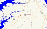
Maryland Route 300 is a state highway
in the U.S. state
of Maryland
. Known for most of its length as Sudlersville Road, the state highway runs 13.55 miles (21.8 km) from MD 213
in Church Hill
east to the Delaware
state line, where the highway continues as Delaware Route 300
(DE 300). MD 300, which connects Church Hill with Sudlersville
in northern Queen Anne's County
, is officially separated into two sections, MD 300 and MD 300A, separated by a superstreet
intersection with U.S. Route 301
(US 301). MD 300 is a part of the National Highway System
between US 301 and the Delaware state line. MD 300 between Church Hill and Dudley Corners was one of the original state roads marked for improvement in 1909. The highway was completed between Church Hill and Sudlersville around 1920. MD 300 between Sudlersville and the Delaware state line was constructed in the late 1920s and early 1930s.
(Main Street) before leaving the town and heading northeast through farmland. The state highway intersects US 301 (Blue Star Memorial Highway) at a superstreet intersection. Traffic on MD 300 is required to turn right onto US 301, perform a U-turn, then turn right again to continue on MD 300. Now officially MD 300, the highway continues northeast before curving east at the crossing of Red Lion Branch and intersecting MD 290
(Crumpton Road) and Benton Corners Road at Dudley Corners. The state highway heads east to the town of Sudlersville, where the highway's name changes to Main Street. MD 300 intersects MD 837 (Church Circle) and MD 313
(Church Street) before crossing the Centreville Branch of the Northern Line of the Maryland and Delaware Railroad
. MD 300 becomes Sudlersville Road again upon leaving town, crossing Unicorn Branch and intersecting Duhamel Corner Road. The state highway passes through a mix of farmland and forest as it meets Peters Corner Road and crosses Andover Branch. MD 300 curves to the northeast at Busic Church Road to its eastern terminus at the Delaware state line. Sudlersville Road continues east as DE 300 toward Kenton
and Smyrna
.
, by the Maryland State Roads Commission in 1909. By 1915, this segment was uncompleted, but the segment of the highway between Dudley Corners and Sudlersville was completed as a state aid road. The link between Church Hill and Dudley Corners was completed between 1919 and 1921. The section between Sudlersville and the Delaware state line was started in 1926 with the paving of Main Street east of MD 313 in Sudlersville completed in 1927. The highway was extended to Duhamel Corner Road in 1928, to Peters Corner Road in 1930, and to the state line by 1933. When MD 213's bypass of Church Hill was completed in 1971, MD 300 was extended west to its present terminus. MD 300A was designated along the portion of MD 300 west of US 301 when the superstreet intersection between the two highways was installed in 2005.
.
{|class=wikitable
!Location
!Mile
!Intersection
!Notes
|-
|rowspan=2|Church Hill
|0.00
|
|Western terminus of MD 300A
|-
|0.16
|
|Old alignment of MD 213
|-
|
|3.92
|, Wilmington
|Superstreet
intersection; eastern terminus of MD 300A; western terminus of MD 300
|-
|Dudley Corners
|5.52
| / Benton Corners Road – Crumpton
|
|-
|rowspan=2|Sudlersville
|7.28
|
|
|-
|7.34
|
|
|-
|
|13.55
| – Kenton, DE
, Smyrna, DE
|Eastern terminus of MD 300; Delaware
state line
State highway
State highway, state road or state route can refer to one of three related concepts, two of them related to a state or provincial government in a country that is divided into states or provinces :#A...
in the U.S. state
U.S. state
A U.S. state is any one of the 50 federated states of the United States of America that share sovereignty with the federal government. Because of this shared sovereignty, an American is a citizen both of the federal entity and of his or her state of domicile. Four states use the official title of...
of Maryland
Maryland
Maryland is a U.S. state located in the Mid Atlantic region of the United States, bordering Virginia, West Virginia, and the District of Columbia to its south and west; Pennsylvania to its north; and Delaware to its east...
. Known for most of its length as Sudlersville Road, the state highway runs 13.55 miles (21.8 km) from MD 213
Maryland Route 213
Maryland Route 213 is a state highway located on the Eastern Shore of Maryland in the United States. The route runs from Maryland Route 662 in Wye Mills, Queen Anne's County north to the Pennsylvania border in Cecil County, where it continues into that state as Pennsylvania Route 841...
in Church Hill
Church Hill, Maryland
Church Hill is a town in Queen Anne's County, Maryland, United States. The population was 530 at the 2000 census. Joshua Seney was born near Church Hill, and is buried on his property near the town.-Geography:...
east to the Delaware
Delaware
Delaware is a U.S. state located on the Atlantic Coast in the Mid-Atlantic region of the United States. It is bordered to the south and west by Maryland, and to the north by Pennsylvania...
state line, where the highway continues as Delaware Route 300
Delaware Route 300
Delaware Route 300 is a state highway in Kent County, Delaware. The route is a continuation of Maryland Route 300 from the Maryland border near Everetts Corner. It runs in a northeast direction from there to Smyrna, where it ends at U.S. Route 13...
(DE 300). MD 300, which connects Church Hill with Sudlersville
Sudlersville, Maryland
Sudlersville is a town in Queen Anne's County, Maryland. The ZIP code is 21668 and the area code is 410. The population was 391 at the 2000 census...
in northern Queen Anne's County
Queen Anne's County, Maryland
Queen Anne's County is a county located on the Eastern Shore of the U.S. state of Maryland.As of 2010, the population was 47,798. Its county seat and most populous municipality is Centreville. The census-designated place of Stevensville is the county's most populous place...
, is officially separated into two sections, MD 300 and MD 300A, separated by a superstreet
Superstreet
A superstreet is a type of road intersection that is a variation of the Michigan left. In this configuration, traffic on the minor road is not permitted to proceed straight across the major road or highway; traffic wishing to turn left or go straight must turn right onto the major road, make a...
intersection with U.S. Route 301
U.S. Route 301 in Maryland
U.S. Route 301 in Maryland is a major highway that runs from Delaware to the Governor Harry W. Nice Memorial Bridge into Virginia. It passes through three of Maryland's four main regions: the Eastern Shore, the Baltimore-Washington Metropolitan Area, and Southern Maryland...
(US 301). MD 300 is a part of the National Highway System
National Highway System (United States)
The National Highway System is a network of strategic highways within the United States, including the Interstate Highway System and other roads serving major airports, ports, rail or truck terminals, railway stations, pipeline terminals and other strategic transport facilities.Individual states...
between US 301 and the Delaware state line. MD 300 between Church Hill and Dudley Corners was one of the original state roads marked for improvement in 1909. The highway was completed between Church Hill and Sudlersville around 1920. MD 300 between Sudlersville and the Delaware state line was constructed in the late 1920s and early 1930s.
Route description
MD 300 begins at an intersection with MD 213 (Church Hill Road) in Church Hill. The highway, officially MD 300A, heads east as two-lane Sudlersville Road and intersects MD 19Maryland Route 19
Maryland Route 19 is a state highway in the U.S. state of Maryland. Known for much of its length as Roberts Station Road, the state highway runs from MD 213 in Church Hill east to MD 313 in Ingleside. MD 19 runs through central Queen Anne's County, connecting both communities with U.S. Route...
(Main Street) before leaving the town and heading northeast through farmland. The state highway intersects US 301 (Blue Star Memorial Highway) at a superstreet intersection. Traffic on MD 300 is required to turn right onto US 301, perform a U-turn, then turn right again to continue on MD 300. Now officially MD 300, the highway continues northeast before curving east at the crossing of Red Lion Branch and intersecting MD 290
Maryland Route 290
Maryland Route 290 is a state highway in the U.S. state of Maryland. The state highway runs from MD 300 at Dudley Corners north to MD 299 in Sassafras. MD 290 roughly parallels U.S. Route 301 , which it intersects twice, as it connects the communities of Crumpton in northern Queen Anne's County...
(Crumpton Road) and Benton Corners Road at Dudley Corners. The state highway heads east to the town of Sudlersville, where the highway's name changes to Main Street. MD 300 intersects MD 837 (Church Circle) and MD 313
Maryland Route 313
Maryland Route 313 is a state highway located on the Eastern Shore of Maryland in the United States. The route runs from U.S. Route 50 in Mardela Springs, Wicomico County north to Maryland Route 213 and Maryland Route 290 in Galena, Kent County...
(Church Street) before crossing the Centreville Branch of the Northern Line of the Maryland and Delaware Railroad
Maryland and Delaware Railroad
The Maryland and Delaware Railroad Company is a Class III short-line railroad, formed in 1977 to operate several branch lines of the former Penn Central Railroad in both Maryland and Delaware. These branches were omitted from the system plan for Conrail in 1976 and would have been discontinued...
. MD 300 becomes Sudlersville Road again upon leaving town, crossing Unicorn Branch and intersecting Duhamel Corner Road. The state highway passes through a mix of farmland and forest as it meets Peters Corner Road and crosses Andover Branch. MD 300 curves to the northeast at Busic Church Road to its eastern terminus at the Delaware state line. Sudlersville Road continues east as DE 300 toward Kenton
Kenton, Delaware
Kenton is a town in Kent County, Delaware, United States. It is part of the Dover, Delaware Metropolitan Statistical Area. The population was 261 at the 2010 census.-Geography:Kenton is located at ....
and Smyrna
Smyrna, Delaware
Smyrna is a town in Kent and New Castle counties in the U.S. state of Delaware. It is part of the Dover, Delaware Metropolitan Statistical Area...
.
History
The portion of MD 300 between Church Hill and Dudley Corners was designated one of the original state roads, as part of a connection to CrumptonCrumpton, Maryland
Crumpton is an unincorporated community in Queen Anne's County, Maryland, United States. Crumpton is located along the Chester River west-southwest of Millington. Crumpton has a post office with ZIP code 21628....
, by the Maryland State Roads Commission in 1909. By 1915, this segment was uncompleted, but the segment of the highway between Dudley Corners and Sudlersville was completed as a state aid road. The link between Church Hill and Dudley Corners was completed between 1919 and 1921. The section between Sudlersville and the Delaware state line was started in 1926 with the paving of Main Street east of MD 313 in Sudlersville completed in 1927. The highway was extended to Duhamel Corner Road in 1928, to Peters Corner Road in 1930, and to the state line by 1933. When MD 213's bypass of Church Hill was completed in 1971, MD 300 was extended west to its present terminus. MD 300A was designated along the portion of MD 300 west of US 301 when the superstreet intersection between the two highways was installed in 2005.
Junction list
The entire route is in Queen Anne's CountyQueen Anne's County, Maryland
Queen Anne's County is a county located on the Eastern Shore of the U.S. state of Maryland.As of 2010, the population was 47,798. Its county seat and most populous municipality is Centreville. The census-designated place of Stevensville is the county's most populous place...
.
{|class=wikitable
!Location
!Mile
!Intersection
!Notes
|-
|rowspan=2|Church Hill
Church Hill, Maryland
Church Hill is a town in Queen Anne's County, Maryland, United States. The population was 530 at the 2000 census. Joshua Seney was born near Church Hill, and is buried on his property near the town.-Geography:...
|0.00
|
|Western terminus of MD 300A
|-
|0.16
|
|Old alignment of MD 213
|-
|
|3.92
|, Wilmington
Wilmington, Delaware
Wilmington is the largest city in the state of Delaware, United States, and is located at the confluence of the Christina River and Brandywine Creek, near where the Christina flows into the Delaware River. It is the county seat of New Castle County and one of the major cities in the Delaware Valley...
|Superstreet
Superstreet
A superstreet is a type of road intersection that is a variation of the Michigan left. In this configuration, traffic on the minor road is not permitted to proceed straight across the major road or highway; traffic wishing to turn left or go straight must turn right onto the major road, make a...
intersection; eastern terminus of MD 300A; western terminus of MD 300
|-
|Dudley Corners
|5.52
| / Benton Corners Road – Crumpton
Crumpton, Maryland
Crumpton is an unincorporated community in Queen Anne's County, Maryland, United States. Crumpton is located along the Chester River west-southwest of Millington. Crumpton has a post office with ZIP code 21628....
|
|-
|rowspan=2|Sudlersville
Sudlersville, Maryland
Sudlersville is a town in Queen Anne's County, Maryland. The ZIP code is 21668 and the area code is 410. The population was 391 at the 2000 census...
|7.28
|
|
|-
|7.34
|
|
|-
|
|13.55
| – Kenton, DE
Kenton, Delaware
Kenton is a town in Kent County, Delaware, United States. It is part of the Dover, Delaware Metropolitan Statistical Area. The population was 261 at the 2010 census.-Geography:Kenton is located at ....
, Smyrna, DE
Smyrna, Delaware
Smyrna is a town in Kent and New Castle counties in the U.S. state of Delaware. It is part of the Dover, Delaware Metropolitan Statistical Area...
|Eastern terminus of MD 300; Delaware
Delaware
Delaware is a U.S. state located on the Atlantic Coast in the Mid-Atlantic region of the United States. It is bordered to the south and west by Maryland, and to the north by Pennsylvania...
state line