
Maryland Route 289
Encyclopedia
Maryland Route 289 is a state highway
in the U.S. state
of Maryland
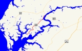
. Known for most of its length as Quaker Neck Road, the state highway runs 8.83 miles (14.2 km) from the junction of Lands End Road and Cliffs City Road near Cliffs City north to MD 213
in Chestertown
. MD 289 serves Quaker Neck, a peninsula between Langford Creek and the Chester River
southwest of Chestertown in Kent County
. The state highway was constructed from Chestertown beginning in the early 1920s, reaching Pomona
in the mid 1920s and Cliffs City around 1930. MD 289 was rerouted within Chestertown in the 1980s and early 1990s.
and U.S. Route 213, respectively, in 1927. MD 289 was extended south to its present southern terminus in Cliffs City in 1929 and 1930. The present bridge over Radcliffe Creek was built in 1949. Queen Street between High Street and MD 213 was returned to municipal maintenance by 1985. MD 289 was disconnected from Queen Street and moved to a newly-built S-curve to come into town on Cross Street by 1994.
.
{|class=wikitable
!Location
!Mile
!Destinations
!Notes
|-
|Cliffs City
|0.00
|Lands End Road west / Cliffs City Road south
|Southern terminus
|-
|Pomona
|3.91
|Quaker Neck Landing Road south
|Former MD 661
|-
|
|6.53
|Wilkins Lane south
|Former MD 664
|-
|rowspan=2|Chestertown
|8.68
|High Street
|Old alignment of MD 20
|-
|8.83
|
|Northern terminus
State highway
State highway, state road or state route can refer to one of three related concepts, two of them related to a state or provincial government in a country that is divided into states or provinces :#A...
in the U.S. state
U.S. state
A U.S. state is any one of the 50 federated states of the United States of America that share sovereignty with the federal government. Because of this shared sovereignty, an American is a citizen both of the federal entity and of his or her state of domicile. Four states use the official title of...
of Maryland
Maryland
Maryland is a U.S. state located in the Mid Atlantic region of the United States, bordering Virginia, West Virginia, and the District of Columbia to its south and west; Pennsylvania to its north; and Delaware to its east...
. Known for most of its length as Quaker Neck Road, the state highway runs 8.83 miles (14.2 km) from the junction of Lands End Road and Cliffs City Road near Cliffs City north to MD 213
Maryland Route 213
Maryland Route 213 is a state highway located on the Eastern Shore of Maryland in the United States. The route runs from Maryland Route 662 in Wye Mills, Queen Anne's County north to the Pennsylvania border in Cecil County, where it continues into that state as Pennsylvania Route 841...
in Chestertown
Chestertown, Maryland
Chestertown is a town in Kent County, Maryland, United States. The population was 4,746 at the 2000 census. It is the county seat of Kent County. The ZIP code is 21620 and the area codes are 410 and 443...
. MD 289 serves Quaker Neck, a peninsula between Langford Creek and the Chester River
Chester River
The Chester River is a major tributary of the Chesapeake Bay on the Delmarva Peninsula. It is about long, and its watershed encompasses , which includes of land. Thus the total watershed area is 20% water. It forms the border between Kent County and Queen Anne's County, Maryland, with its...
southwest of Chestertown in Kent County
Kent County, Maryland
Kent County is a county located in the U.S. state of Maryland, on its Eastern Shore. It was named for the county of Kent in England. Its county seat is Chestertown. In 2010, the county population was 20,197...
. The state highway was constructed from Chestertown beginning in the early 1920s, reaching Pomona
Pomona, Maryland
Pomona is an unincorporated community in Kent County, Maryland, United States.-References:...
in the mid 1920s and Cliffs City around 1930. MD 289 was rerouted within Chestertown in the 1980s and early 1990s.
Route description
MD 289 begins at a wye between Lands End Road and Cliffs City Road near Cliffs City. The state highway heads north as two-lane Quaker Neck Road, which immediately has a sharp curve to the east and a more gentle curve to the northeast. MD 289 continues through a mix of farmland and forest, passing through a sharp curve north and passing by Quaker Neck Landing Road before reaching the village of Pomona, where the highway curves to the east at Pomona Road. The state highway passes Wilkins Lane before curving to the north, crossing a creek before closely paralleling the Chester River, where the road passes some residential subdivisions. After crossing Radcliffe Creek, MD 289 enters the town limits of Chestertown, passing by Philip G. Wilmer Park and passing through a sharp S-curve. The state highway continues northeast through downtown Chestertown as Cross Street, intersecting High Street and passing Fountain Park, the Kent County Courthouse, and other buildings in the Chestertown Historic District before reaching its northern terminus at MD 213 (Maple Avenue). The roadway continues north as Philosophers Terrace.History
MD 289 was paved from the town limits of Chestertown south to Wilkins Lane by 1923. In 1924 and 1925, the state highway was extended south to Pomona. In addition, Queen Street in Chestertown was paved to connect the highway to High Street and Maple Avenue, which would be designated MD 20Maryland Route 20
Maryland Route 20 is a state highway in the U.S. state of Maryland. The state highway runs from Beach Road and Lawton Avenue in Rock Hall east to MD 291 in Chestertown. MD 20, which connects Chestertown with several villages in western Kent County, was designated one of the original state roads...
and U.S. Route 213, respectively, in 1927. MD 289 was extended south to its present southern terminus in Cliffs City in 1929 and 1930. The present bridge over Radcliffe Creek was built in 1949. Queen Street between High Street and MD 213 was returned to municipal maintenance by 1985. MD 289 was disconnected from Queen Street and moved to a newly-built S-curve to come into town on Cross Street by 1994.
Junction list
The entire route is in Kent CountyKent County, Maryland
Kent County is a county located in the U.S. state of Maryland, on its Eastern Shore. It was named for the county of Kent in England. Its county seat is Chestertown. In 2010, the county population was 20,197...
.
{|class=wikitable
!Location
!Mile
!Destinations
!Notes
|-
|Cliffs City
|0.00
|Lands End Road west / Cliffs City Road south
|Southern terminus
|-
|Pomona
Pomona, Maryland
Pomona is an unincorporated community in Kent County, Maryland, United States.-References:...
|3.91
|Quaker Neck Landing Road south
|Former MD 661
|-
|
|6.53
|Wilkins Lane south
|Former MD 664
|-
|rowspan=2|Chestertown
Chestertown, Maryland
Chestertown is a town in Kent County, Maryland, United States. The population was 4,746 at the 2000 census. It is the county seat of Kent County. The ZIP code is 21620 and the area codes are 410 and 443...
|8.68
|High Street
|Old alignment of MD 20
|-
|8.83
|
|Northern terminus